
In early November of 2013 the monster Typhoon Haiyan roared ashore in the Central Philippines claiming over 8,000 souls and rendering many thousands more homeless. It was the strongest storm ever recorded on Earth over land — boasting winds exceeding 190 mph and pressures below 900 mb. It formed over ocean surface waters that were far warmer than normal and whose heat extended much further into the ocean depths than was typical. The kind of powerful storm that many atmospheric scientists say is more likely to occur as humans keep heating the ocean and atmosphere, providing fuel and conditions to make the most intense storms ever stronger.
Today, more than a year later, 15,000 people are still living in tents along a swath that saw more than 4 million homes destroyed as Haiyan made landfall. Climate and extreme weather refugees in a world that is, sadly, seeing more and more dislocated people. People affected by drought, water loss, and by the devastation of storms. From Syria to Brazil to California to the Philippines, the refrain is the same. Bad weather pushed people to the edge or over. It took their homes or made living where they are a nightmare.
And, for a Philippines still reeling from Haiyan’s brutal blow, it may just be happening again.

(December 4 infrared satellite shot of Hagupit as it approaches the central Philippines. Image source: NOAA MTSAT.)
As of yesterday afternoon Hagupit had bombed out into a category 5 monster storm boasting 1 minute sustained winds of 180 mph and a minimum central pressure of 905 mb. This put Hagupit in a tie with super typhoons Vongfong and Nuri as the strongest storms of 2014. Not quite as strong as Haiyan, but still a very dangerous storm. One strong enough to fling out 50 foot waves and bring a storm surge as tall as a two story house to Philippine shores.
Over the next few days Hagupit is expected to steadily weaken, roaring ashore in the Central Philippines as a strong Category 4 or weak Category 5 before slowly churning off toward the WNW toward Manila.
Hagupit is a gradual mover and covers a relatively broad area. The result is that tropical storm and intense typhoon conditions will persist over regions for longer periods than occurred with Haiyan, even if Hagupit is not quite as powerful. As mentioned above, of serious concern is that the currently predicted track of Hagupit will bring it near or over regions that have yet to fully recover from the terrible impacts of Haiyan.
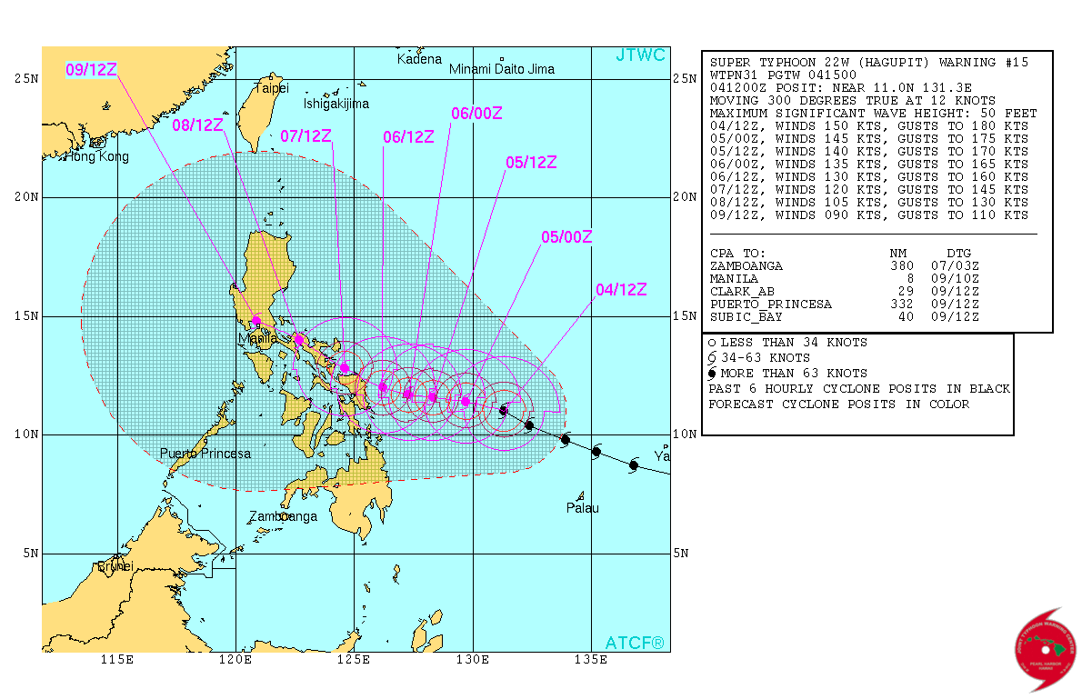
(Predicted track and strength of Hagupit. Image source: Joint Typhoon Warning Center.)
Overall, the predicted track is a bit to the north of Haiyan’s shoreward surge of last year. However, the hardest hit areas are still uncomfortably close to the guidance cone. In addition, the current projected path features more flood prone coastal regions than Haiyan’s path. With many bay features to funnel in and amplify a storm surge.
Along this track, the storm would primarily be a major rainfall concern by the time it reached the capital city of Manila.
Climatology — Very Strong Supertyphoon in December Feature of a Globe in Hot Water
Climatologically, it’s a bit odd for such a strong storm to form in December, even in the warm Western Pacific (at peak intensity, Hagupit was the strongest December cyclone in at least the past 15 years). During recent years and under the apparent influence of a heating climate this region has tended to feature tropical cyclone formation year-round. A phenomena that some atmospheric scientists expect to continue to ramp up with human-caused warming.

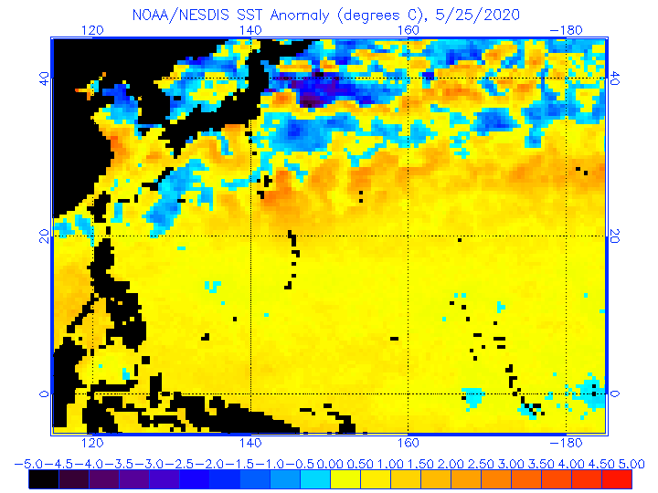
(Sea surface temperature anomaly for the Western Pacific in the vicinity of the Philippines. Image source: NOAA Sea Surface Temperature Anomaly Charts.)
Sea surface temperatures for the region remain in a very hot range of 0.5 to 2 degrees Celsius above the 20th Century average. Meanwhile, temperatures at depth are in the slightly above average range. So Hagupit has plenty of energy to feed on, even if conditions aren’t quite as favorable as they were for Haiyan last year.
Perhaps more striking is the persistence and intensity of ocean surface heat on both the regional and global levels. GFS models for the past 8 months have shown positive ocean surface anomalies in the range of +0.6 to +1.4 C above the 20th Century average. A very, very hot world ocean, especially when we consider that the typical major ocean heating event called El Nino was in neutral status throughout this period. In this context, it is also worth noting that January through October of 2014 was the hottest such period for the world surface in all of the 136 year global climate record. Again, occurring without the added heating influence of a declared El Nino.
The Western Pacific, itself, is the hottest ocean zone in the world. And high temperature departures there have been implicated both in increasing storminess at the surface and in a troubling heightening of the troposphere over a warm and warming region.
It is in this context that we should consider the extraordinary storms we’ve recently witnessed and the major potential impacts of Hagupit over the coming days.
* * * * *
* * * * *
UPDATE: Thursday, Hagupit went through an eye replacement cycle as well as a brief period of weakening. This caused the storm to temporarily dip below super typhoon intensity (150 mph). As of Friday morning (EST), Hagupit had re-strengthened to a 150 mph monster storm with a very low central pressure of 915 mb.
A large and intense storm that is, at least one day ahead of landfall, already pushing seas to the steps of homes, washing out roads in the city of Samar where Hagupit is expected to make landfall, and lashing the Philippine coast with intense squalls.
It is worth noting that many communities in Samar and along the Philippine coast are low-lying and are thus very vulnerable to the effects of Hagupit. A fact the Philippine government appears well aware of as it has already evacuated more than 500,000 people ahead of landfall.
The storm will also race ashore over seas already elevated by human-caused climate change, though the peak of the warm water bulge has shifted east in a broader transition toward more El Nino-like conditions for the Equatorial Pacific.
Wind Shear — Limiting Storm Intensity
Hagupit is feeling the impacts of wind shear to its south and west and this influence is likely to keep the storm below the terrible intensities seen during Haiyan.

(Hagupit feeling the effects of southwest wind shear on December 5, 2014. Despite these influences, Hagupit is maintaining status as a strong category 4 storm. Image source: NOAA MTSAT.)
It is, nonetheless, predicted to be a very powerful storm — raking the Philippine Coast with category 4 winds (135-155 mph), monster waves, storm surges in excess of 10 feet and dumping 10-25 inches of rainfall over very broad regions. Areas along the path of the storm are likely to be heavily impacted by rainfall as the storm weakens and dumps copious moisture. The expected very heavy rainfall has also prompted lahar warnings for mudslides on the flanks of volcanos Mayan and Bulusan — both in Hagupit’s path.

(Updated track of Hagupit from the Joint Typhoon Warning Center)
Hagupit’s current projected track brings its center about 50-100 miles north of Haiyan’s path. This predicted motion would spare regions hardest hit by Haiyan from Hagupit’s worst impacts. However, recent satellite imagery depicts a bit of a southward jog. This recent motion, combined with the storm’s broad size and slow forward speed, mean these regions may still take a substantial beating.
The storm is a slow mover — advancing only at a rate of 5-10 miles per hour. So regions will feel the impacts of Hagupit for much longer than Haiyan. For the Philippines as a whole, it looks like this will be a three day event. A longer duration storm, though somewhat less intense.
Links:
NOAA Sea Surface Temperature Anomaly Charts
More than 15,000 People Still Living in Tents a Year After Haiyan
James Reynolds — Providing Live Updates From Samar on His Twitter Feed
Hat tip to Colorado Bob
(Post Edited on December 5)


Aldous
/ December 4, 2014Opening paragraph reads, “In early November of 2014.” I believe it should say November 2013. Another great article! Thanks for all your work.
LikeLike
robertscribbler
/ December 4, 2014Thanks Aldus. Got it!
LikeLike
Wharf Rat
/ December 4, 2014From Greg Laden’s blog…
“Fishing in pink waters: How scientists unraveled the El Niño mystery” is an amazing piece of work written by Daniel Gross (I made minuscule contributions), looking at the history of the science of the El Nino Southern Oscillation, which is one of the most important climate or weather related things on this planet. This is timely, because we are expecting an El Niño to form over the winter. Maybe. Well, eventually we will have an El Niño. (It has been an unusually long time since the last strong one.)
http://roadtoparis.info/2014/12/04/el-nino-mystery-pink-waters-scientists/
LikeLike
robertscribbler
/ December 4, 2014Thanks for this contribution, Wharf. Very well done article.
And, yes, this El Nino has been building for quite some time, hasn’t it?
LikeLike
Mark in New England
/ December 4, 2014Robert,
In the opening paragraph, I think you mean November 2013, not 2014, as in here: “In early November of 2014 the monster Typhoon Haiyan roared ashore in the Central Philippines …”
LikeLike
robertscribbler
/ December 4, 2014Got it!
LikeLike
Mark in New England
/ December 4, 2014Excellent article, Robert.
LikeLike
Ouse M.D.
/ December 4, 2014The more I’m thinking about what’s going on, the more I’m getting the impression that through the comforts of industrial revolution we got so disconnected from nature, that we needed all this science to eventually realize the obvious:
we literally “can’t live” disconnected from nature.
LikeLike
robertscribbler
/ December 4, 2014Nature is a give and take. If it’s just take, take, take from nature, then, eventually, what you get back is a wretched existence — if it is existence at all.
LikeLike
Michael Hornick
/ December 4, 2014Hey Robert,
I enjoy reading your blog so much. Thanks.
There is something that has been on my mind for a long time and I don’t know if you’ve written about this before. If not, I think it would be interesting to look into further. The issue is simple. Basically it takes much and I mean much more energy to melt ice than to warm the newly melted ice water. It takes some 334 joules of energy to melt a cubic centimetre of ice, and if I understand it correctly, then some 4.2 joules to warm it another degree. So clearly the ice caps moderate the earth, but once the sea ice is gone, which won’t be long now, wow, I think the ocean is going to be heating up very quickly. That will be disastrous just another thing to worry about.
https://www.youtube.com/watch?v=0n5iL3Gg_mg at about minute 2.
Michael Hornick
LikeLike
robertscribbler
/ December 4, 2014Mike —
There are some odd random bits coming in through this post. Just something to keep an eye on.
RE melting ice caps as a moderator to warming… Absolutely. The ice serves as a cooling mechanism and moderates climate so long as it remains in high enough volumes. Melting ice itself is a negative feedback to warming as it is a huge heat sink and can set off a few other sinks in the global system. We’ll almost certainly see this effect as global temperatures approach the 2 C threshold at which the major ice sheets more and more rapidly destabilize. The upshot being localized ocean and atmospheric cooling and major storms in the context of overall warming.
At the most rapid pace, it will take centuries for the ice sheets to go down entirely. So the warming through the 2-5 C threshold is a gigantic mess. After that, you do get a bump due to the fact that you no longer have the ice sheets as moderators.
In any case, the ocean is still the largest contributor to warming inertia. Just due to its massive volume and it’s relative ability to keep cooler water at depth. But, in a hothouse, this changes as the deep ocean warms up as well. It is no small irony that the melting ice sheets put in place mechanisms that drive the deep ocean to more rapidly warm — stratification and transition to a Canfield Ocean.
LikeLike
wili
/ December 4, 2014IIRC, a significant contributor to the high storm surge from Haiyan was the fact that there was a ‘bulge’ of higher than normal sea level to the east of the Philippines from the persistent winds blowing westward. Do you know if this is still the case? (And am I just remembering this all wrong?)
LikeLike
robertscribbler
/ December 4, 2014This is a feature (west winds) of the large Haiyan surge that I wasn’t aware of. Although SSTs in the region could have generated a warm water bulge.
LikeLike
Griffin
/ December 5, 2014Wili, I recall a scientist (Trenberth?) discussing that local rise in sea level that you are referring to. It was significant in that the Westerly wind bursts that followed the weakened trades last spring were said to have resulted in a shift of that bulge towards the central Pacific. Sea levels on the East side of the Philippines had dropped by a few inches as a result. I have no idea how long the situation stayed that way or if it returned to the previously raised levels again.
LikeLike
robertscribbler
/ December 5, 2014Now I do recall… The strong easterlies piled up water in the Western Pacific prior to Haiyan. Coincident with the easterlies, this region experienced very strong sea surface warning that eventually translated far below the surface. The result was a bulge of higher water levels.
With the strong and then moderate Kelvin waves since, much of this expanded and heated water has transferred across the Pacific into the mid ocean or over to EPAC. So this storm doesn’t have as high a launching pad as Haiyan.
LikeLike
Colorado Bob
/ December 4, 2014Antarctic seawater temperatures rising
The temperature of the seawater around Antarctica is rising according to new research from the University of East Anglia.
New research published today in the journal Science shows how shallow shelf seas of West Antarctica have warmed over the last 50 years.
The international research team say that this has accelerated the melting and sliding of glaciers in the area, and that there is no indication that this trend will reverse.
It also reveals that other Antarctic areas, which have not yet started to melt, could experience melting for the first time with consequences for sea-level rise.
Read more at: http://phys.org/news/2014-12-antarctic-seawater-temperatures.html#jCp
LikeLike
todaysguestis
/ December 4, 2014“If the shoaling of warm water masses continues, it is expected that there will be major environmental changes with dramatic consequences for the Filchner or Ronne Ice Shelf, too. For the first time glaciers outside the West Antarctic could experience enhanced melting from below.”
http://www.geomar.de/en/service/kommunikation/singlepm/article/antarktis-waerme-kommt-aus-der-tiefe/
LikeLike
robertscribbler
/ December 4, 2014This is a rough report. I have a lot of catching up to do.
LikeLike
robertscribbler
/ December 4, 2014The article gives no idea as to at what depth these readings were taken. It also makes a statement to the effect that the whole ice sheet won’t melt. It will if we hit and exceed or maintain 550 to 600 ppm CO2e forcing in the atmosphere. At current emissions rates, we are 25 years away from hitting that threshold.
LikeLike
Colorado Bob
/ December 4, 2014Cat 5 Super Typhoon Hagupit Poised to Hit Philippine Islands Devastated by Haiyan
By: Dr. Jeff Masters , 4:32 PM GMT on December 04, 2014
Super Typhoon Hagupit has exploded into mighty Category 5 storm with 175 mph winds and a central pressure of 905 mb, and is threatening the same portion of the Philippine Islands devastated by Super Typhoon Haiyan in November 2013. The spiral bands of the massive storm are already bringing gusty winds and heavy rain showers to Samar and Leyte Islands, which bore the brunt of Haiyan’s massive storm surge and incredible winds–rated at 190 mph at landfall on November 7, 2013 by the Joint Typhoon Warning Center. Haiyan killed over 7,000 people in the Philippines, with Tacloban (population 200,000) suffering the greatest casualties, thanks to a 20+’ storm surge. Thousands of people still live in tents in Tacloban in the wake of Haiyan, and mass evacuations have begun to get these vulnerable people to safety.
http://www.wunderground.com/blog/JeffMasters/comment.html?entrynum=2872
LikeLike
robertscribbler
/ December 4, 2014Thanks for this, Bob. Very relevant update.
LikeLike
robertscribbler
/ December 4, 2014Actually, this is from a report earlier today. Looks like the storm is at 155 mph intensity now.
LikeLike
Colorado Bob
/ December 4, 2014Deforestation May Be at Root of Brazil Drought
It’s not just Brazil but South America as a whole for which these rivers in the sky play a pivotal meteorological role, according to a recent study by a top Brazilian climate scientist, Antonio Nobre of the government’s Center for Earth System Science.
The study draws together data from multiple researchers to show that the Amazon may be closer to a tipping point than the government has acknowledged and that the changes could be a threat to climates around the globe. His work is causing a stir in drought-stricken Brazil as environmental negotiators meet in neighboring Peru at the Dec. 1-12 U.N. climate talks. …………………………………. Earlier this year, researchers at the University of Minnesota highlighted two “once-in-a-century-level droughts” occurring in 2005 and 2010 in the region, in a peer-reviewed study in the Journal of Climate. They used climate simulations to find that deforestation “has the potential to increase the impact of droughts in the Amazon basin.”
The sky rivers are generated by the forest acting as a massive pump, according to research that has shown the jungle’s uniform humidity consistently lowers atmospheric pressure in the Amazon basin. That allows it to draw moist air currents from the Atlantic Ocean much farther inland than areas that don’t have forests. Those currents travel west across the continent until they hit the Andes mountains, where they pivot and carry rains south to Buenos Aires and east to Sao Paulo.
The trees pump an estimated 20 billion metric tons of water into the atmosphere every day ? 3 billion more than what the Amazon river, the world’s largest, discharges into the ocean.
Link
LikeLike
robertscribbler
/ December 4, 2014Absolutely.
LikeLike
Kevin Jones
/ December 4, 2014If Nature gave a rats ass about the environmental justice movement then surely she would steer Hagupit in other directions. Sadly, She doesn’t….just does her thing. But one day….
LikeLike
robertscribbler
/ December 4, 2014These things will start hitting Japan and China sooner or later.
LikeLike
dtlange
/ December 4, 2014Good post on the typhoon, Robert.
Aldo, it was good to hear mention of the many human casualties amidst this severe climate crisis. The MSM usually frames the human suffering aspect with a economic/dollar amount.
Later.
LikeLike
todaysguestis
/ December 4, 2014Research casts alarming light on decline of West Antarctic glaciers
“The findings from West Antarctica could call into question one principal finding from the latest report of the United Nations’ Intergovernmental Panel on Climate Change (IPCC), considered to be the world authority on global warming. In 2013, the panel put its high-end projection for likely global sea-level rise, by the year 2100, at a little more than three feet.
But the researchers studying West Antarctica aren’t so sure. “The upper bound defined by the IPCC, they may underestimate some of the components, particularly the ice sheets,” said Isabella Velicogna of the University of California at Irvine, an author of the paper estimating the rate of ice loss from West Antarctica’s glaciers.
So how fast could the loss of West Antarctica unfold? Velicogna’s co-author, Eric Rignot of the University of California at Irvine, suggested that in his view, within 100 to 200 years, one-third of West Antarctica could be gone.
Rignot noted that the scientific community “still balks at this” — particularly the 100-year projection — but said he thinks observational studies are showing that ice sheets can melt at a faster pace than model-based projections take into account.”
http://www.washingtonpost.com/national/health-science/research-casts-alarming-light-on-decline-of-west-antarctic-ice-sheets/2014/12/04/19efd3e4-7bbe-11e4-84d4-7c896b90abdc_story.html
LikeLike
robertscribbler
/ December 4, 2014I stand by my projection of 3-9 feet this century. After reading some of the stuff coming from the climate modelers on CO2, I can see how the broader scientific community keeps low-balling this. There still seems to be quite a lot of reticence on the issue of climate sensitivity and related likely impacts including geophysical changes.
LikeLike
todaysguestis
/ December 4, 2014Hi Robert,
Not sure I follow what you mean by…
“After reading some of the stuff coming from the climate modelers on CO2, I can see how the broader scientific community keeps getting this wrong. ”
Would you mind going into a little more detail.
Thanks.
LikeLike
robertscribbler
/ December 4, 2014The recent study claiming CO2’s warming impact is felt fully within 10 years is what I was referring to.
If that were true, we’d have already warmed by 1.4 to 2.2 C, not the 0.8 C we see today. Or climate sensitivity is lower. But that begs the questions — why was the Pliocene 2-3 C warmer than 1880 at 400 ppm CO2, and why did it only take a 100 ppm increase in CO2 and related somewhat minor increase in methane to sustain a 4-5 C warming at the end of the last ice age?
When it comes to studies like these, rule 1 is to go back and look at the geological past. And if the study doesn’t jibe, then it’s probably not valid.
LikeLike
todaysguestis
/ December 5, 2014Gotcha! Thanks.
LikeLike
todaysguestis
/ December 4, 2014El Nino’s ‘remote control’ on hurricanes in the Northeastern Pacific
” “We did not connect the discharged heat of El Niño to the fueling of hurricanes until recently, when we noticed another line of active research in the tropical cyclone community that clearly demonstrated that a strong hurricane is able to get its energy not only from the warm surface water, but also by causing warm, deep water – up to 100 meters deep – to upwell to the surface,” Jin
… Furthermore, caution the authors, most climate models predict a slow down of the tropical atmospheric circulation as the mean global climate warms up. This will result in extra heat stored underneath the North-eastern Pacific and thus greatly increase the probability for this region to experience more frequent intense hurricanes.”
Read more at: http://phys.org/news/2014-12-el-nino-remote-hurricanes-northeastern.html#jCp
LikeLike
robertscribbler
/ December 4, 2014It’s an expansive pool of warmth for the storms to draw from. Looks like the zone also shifts more and more toward the US West Coast.
LikeLike
Spike
/ December 5, 2014Corals hit by bleaching in 2014 with concerns about potential for El Niño impact
http://www.reportingclimatescience.com/news-stories/article/coral-bleaching-outbreak-triggered-by-warming-seas.html
LikeLike
Colorado Bob
/ December 5, 2014This one Hillary quote about climate change is very, very important
But now that video of the full speech is available, it’s obvious that her Keystone dodge is potentially far less important than this portion:
“You pushed for and rallied behind President Obama’s use of the Clean Air Act to set the first ever federal limits on carbon pollution from existing power plants, which are driving the most dangerous effects of climate change. As you know so well, power plants account for about 40 percent of the carbon pollution in the United States, and therefore must be addressed. And the unprecedented action that President Obama has taken must be protected at all cost.
“So this is an exciting time. From the administration’s announcement last month of a $3 billion commitment to the global green climate fund, to that new joint announcement with China, to new rules under consideration for ozone, we continue to push forward. But that is just the beginning of what is needed.”
Taking Clinton at her word, this hints at the ways in which climate could become an important issue in the 2016 race.
Link
LikeLike
robertscribbler
/ December 5, 2014I hope so. We need to start talking about this issue more broadly, more publicly.
LikeLike
Colorado Bob
/ December 5, 2014Study: California drought is the most severe in at least 1,200 years
The current drought in California is the worst the state has seen in at least 1,200 years, according to a recent study published by the American Geophysical Union.
Scientists at Woods Hole Oceanographic Institute and the University of Minnesota reconstructed California’s temperature and precipitation history back to 800 A.D. using tree ring data. Hidden in this millennium of data they found as many as 66 dry periods of at least three to nine years. In the entire 1,200 year period they studied, there were only three droughts that were similar in nature to the current drought.
Though none have been as severe as what California has seen in the three years since 2012. Not even the historic droughts of the late 1970s, nor the late 1980s. The study also found that 2014 was the worst single drought year in the past 1,200 years, and that approximately 44 percent of California’s 3-year droughts have gone on to last another year, or longer.
Link
LikeLike
robertscribbler
/ December 5, 2014Brutal. But we are now looking at two more major rain events in train. The RRR is gone and the pattern looks like a switch from drought to very heavy precipitation, at least for the next week. The current Kelvin Wave is also gaining a bit of steam.
What’s a bit strange is that weak El Ninos usually don’t set off this kind of pattern switch. At least they don’t usually do it so decisively. And we’re not even in a weak El Niño yet. But, for this week at least, the weather pattern is similar to what we’d see in the ramp up to a strong El Niño.
Wouldn’t read too much out if this conjecture, but it’s worth noting.
LikeLike
Colorado Bob
/ December 5, 2014Amid Bugs, Hail, Floods and Bacteria, Italian Olives Take a Beating
Aside from the fly — the Bactrocera oleae, to be precise — severe hailstorms and flooding, and a devastating bacteria in parts of Puglia, Italy’s largest olive oil producing region, cut olive production by about 35 percent.
The devastation has already translated into rising prices in Italy for a family staple, and will soon be felt by consumers worldwide. The commodity price for Italian extra virgin olive oil has doubled since last year, and the outlook is also very bad for Spain, the world’s biggest olive oil producer.
“We anticipate a significant increase in olive oil prices,” starting next February or March, said Lou Di Palo, of Di Palo’s Fine Foods in New York City, who noted that prices were so far stable because the olive oil on shelves was still from last year’s release.
Link
LikeLike
Colorado Bob
/ December 5, 2014African Rainfall Rises with Greenhouse Gases
African rainfall may rise with greenhouse gas levels, according to a new study.
A long-standing mystery known as the African Humid Period began at the end of the last Ice Age, during which intense cumulative rainfall increased abruptly and lasted for nearly 10,000 years. And considering that greenhouse gas levels reached a record high in 2013, researchers believe their findings could foreshadow what Africa can expect as a result of climate change in the future.
“This study is important not only because it explains a long-standing puzzle, but it helps to validate model predictions of how rising greenhouse gas concentrations might change rainfall patterns in a highly populated and vulnerable part of the world,” co-author Peter Clark, an Oregon State University paleoclimatologist, said in a statement.
Some 21,000 years ago during the last days of the Ice Age, glaciers in North America and northern Europe began to melt away. But it was out with the cold and in with the dry, with central Africa consequently experiencing a dry spell that didn’t end until about 14,700 years ago, when intense rain suddenly fell. This drastic climatic shift turned African deserts into grasslands, and caused scientists to scratch their heads.
It wasn’t until this latest study, published in the journal Science, that researchers found a plausible answer.
http://www.natureworldnews.com/articles/10908/20141204/african-rainfall-rises-with-greenhouse-gases.htm
LikeLike
Chris Machens
/ December 5, 2014This Map Shows Why the Philippines Is More Vulnerable Than Ever to Typhoons http://www.newrepublic.com/article/115589/philippines-rising-sea-levels-makes-them-more-vulnerable-typhoons
LikeLike
Andy in San Diego
/ December 5, 2014Looking at null school, nice spinner between Greenland & Labrador
LikeLike
robertscribbler
/ December 5, 2014Yeah, approx 950 mb low there.
LikeLike
AChangingClimate.org
/ December 5, 2014My family are from leyte and were badly affected when Haiyan came around. We have literally just finished rebuilding my grandma’s house after it was flattened, and now a new one is coming along. In all the years they have lived there typhoons this strong in that area were infrequent, now they are happening so often.
I find it an incredible injustice that the Philippines a very poor country is being battered by climate change that the developed world caused.
LikeLike
robertscribbler
/ December 5, 2014Couldn’t agree with you more.
We now have some minor policy action to help poorer nations on the issue of climate change. But with Congress filling up with climate change deniers, fossil fuel cheer leaders, and those who would not give one penny to help the poor (republicans), it appears that appropriate and responsible action will continue to be undermined, sabotaged, and obstructed.
I am deeply sorry for the situation your family finds itself in. And I wish I could say that things will get better. But unfortunately, even with the most concerted responses, conditions will continue to worsen for some time. The best we can hope for now is to prevent the very worst impacts.
And it is unjust. And certainly the poor will feel this first. But those who somehow believe the wealthy are immune are still living in a comfortable and dangerous denial. We’re all on board this ship. And if it goes down, then we go down together — rich and poor alike.
The best thing we could do now is work as hard as we can to prevent more climate change and to help those who are in harm’s way. Those like your family who are captive to events not of their making and who deserve every ounce of our compassion, support, and responsible action.
As for this most recent storm, my best wishes and hopes for you, your family, and all who are in its path.
LikeLiked by 1 person
Colorado Bob
/ December 5, 2014Britain on course for warmest year ever…and climate change is to blame, says Met Office
Central England has not experienced a warmer year since Oliver Cromwell was Lord Protector, figures show
Man-made climate change is probably responsible for Britain experiencing the warmest year since records began, the Met Office has said.
Temperatures across the UK in 2014 were on average 1.6C warmer each day than previous years.
And in Central England, where records date back to the 17th century, the region has not experienced a warmer year since 1659, the year before the restoration of the monarchy, when Richard Cromwell was Lord Protector.
Forecasters said that human influence was likely to be to blame, the first time that the Met Office has attributed warmer temperatures to man-made climate change.
Link
LikeLike
robertscribbler
/ December 5, 2014Good movement on the part of the Met. It still seems to me that the world meteorological and some of the world scientific community woefully lags on this issue, though.
All but 3 percent of the scientific community acknowledges global warming. However, at least half the science is bogged down in various forms of reticence which results in a downplaying of certain aspects of climate risk. Such downplaying leads to a false sense of security and a likely very unhelpful perception that we can delay needed responses. The IPCC, thankfully, continues to push for broad and rapid response (perhaps not rapid enough). But downplaying from some factions on key issues like response to warming from the global carbon store and the potential pace of response from glaciers remains in force as a disturbing element of the mainstream climate science community. In addition, an overall quiet on the issues of currently ongoing and building instances of extreme weather and a rapid stratification and acidification of the world’s oceans is equally disturbing.
It is difficult to communicate climate risks and express the dangers of building hazards due to the out of context nature of the crisis. But the issues must be communicated and the public made fully aware of the hazards so they can make informed political and lifestyle choices.
In the end, if some risks end up being slightly overplayed, we do less harm than if we downplay too much in the hopes of being perfectly correct on every issue. And the threat of climate change is so vast as to be one that would be very difficult to overplay in all its various and deadly aspects.
LikeLike
robertscribbler
/ December 5, 2014Hagupit restrengthened a bit over night. Looks to impact sections of the Philippines as a strong cat 4. Forecast track is a bit north of areas heavily impacted by Haiyan. So, thankfully, those regions will be spared some of the worst effects if the storm follows it’s predicted track.
LikeLike
Spike
/ December 5, 2014With Keystone still grumbling, yet another example of how pipelines can cause disaster.
“It is for sure one of the worst ecological disasters that has ever happened in our country,” added Guy Samet, the Environment Ministry official in charge of southern Israel.
http://www.euronews.com/2014/12/04/massive-oil-spill-floods-israel-nature-reserve/
LikeLike
robertscribbler
/ December 5, 2014Building all the pipelines toward the terrible unconventional fuel source that is tar sands is building an ecological disaster on top of more potential disaster. The tar sands project itself is one of the worst contributors to ongoing and future climate change and the potential rupture of one of those pipelines could have terrible local and regional impacts. These are expensive fuels we can do without and the monies sent chasing them are far better spent in replacements and the efficiencies that help bring down overall consumption.
LikeLike
Andy in San Diego
/ December 5, 2014Sao Paolo is not looking too good for the rainy season yet.
Sistema Canteriera at 8.2%
3.3mm rain so far this month.
Sistema Alto Tiete at 5.1%
9.1mm rain so far this month.
Both should see an average of ~200mm for December.
The image at the bottom of this web page provides a decent graphic to put things into context.
http://sao-paulo.estadao.com.br/noticias/geral,apos-chuvas-nivel-do-sistema-cantareira-se-mantem-estavel,1587746
LikeLike
robertscribbler
/ December 5, 2014That’s a lot of glasses that are less than 1/5 full. The situation in the Pacific points toward less likelihood for rain in this region as well.
It’s another month of praying for water.
Back up toward California we have 2-3 more large storms on the way and the pattern for this week looks like something out of a textbook for super El Niño, even though no El Niño has yet npbeen declared at all.
LikeLike
Colorado Bob
/ December 5, 2014Dr. Masters has a new update ………… One half million people evacuated-
LikeLike
Colorado Bob
/ December 5, 2014Dr. Masters has a new update ………… One half million people evacuated-
http://www.wunderground.com/blog/JeffMasters/comment.html?entrynum=2873
LikeLike
robertscribbler
/ December 5, 2014At least they’re taking this seriously.
LikeLike
Colorado Bob
/ December 5, 2014California Drought, El Niño, Warm Earth (One more time)
http://www.wunderground.com/blog/RickyRood/comment.html?entrynum=320
LikeLike
robertscribbler
/ December 5, 2014Some models show this event as a minor El Nino by January, moderate by JJA of this summer. Potentially an extended event.
LikeLike
Colorado Bob
/ December 5, 2014Climate change already showing effects at Kennedy Space Center
The effects of climate change are already showing up in places from Miami to Alaska, scientists say, but two University of Florida geologists are focusing their attention on one especially noteworthy and vulnerable piece of waterfront real estate: Kennedy Space Center. …………………………………………… Adams and associate professor of geology John Jaeger, who have been studying Cape Canaveral’s dunes and beach since 2009, say the impacts became most apparent after Hurricane Sandy.
“Sandy got a lot of press up north, but it really did a tremendous amount of damage at Cape Canaveral,” Jaeger said. “Areas that had previously been relatively stable for decades … suddenly they were gone.”
Link
LikeLike
Ouse M.D.
/ December 5, 2014I guess that’s also why it was so urgent to test Orion for a Manned Mars Mission in the near future.
To save our sorry asses.
Those who think we could survive on Mars in the long run are out of their minds.
LikeLike
robertscribbler
/ December 5, 2014They’re probably going to need to move the space center.
LikeLike
robertscribbler
/ December 5, 2014Probably in less than two decades. Three at the most.
LikeLike
Ouse M.D.
/ December 5, 2014Two decades.
Not taking into account self- reenforcing feedback loops…
LikeLike
climatehawk1
/ December 5, 2014Thanks, tweet scheduled on this.
LikeLike
james cole
/ December 5, 2014“Hagupit is Earth’s seventh Category 5 storm of 2014”
Put into an historical context, what does this fact say about global warming in this year 2014? Extrapolate forward a bit, how far and fast can storms grow in power given the steady rise in world temperatures? 2C, would that not provide the heat energy in parts of the oceans to make Cat 5 common enough.
Today’s news reported panic in storm targeted areas, I can understand their panic!
LikeLike
robertscribbler
/ December 5, 2014The record year, so far globally, is 2005… Pretty sure 2014 is now within 2 storms of that mark (and probably won’t break it).
Added ocean heat certainly creates more fuel for these storms. And we see the most intense storms growing stronger. I wouldn’t be surprised if we see many zones expanding and regions where storm formation is possible year-round.
Instability is one factor required for storm formation. So if some areas grow stagnant, this may suppress storms (a negative feedback to storms as opposed to the overall positive feedback of ocean warming). Although the influence of ice sheet melt may well provide a boost to just that kind of instability as we progress toward mid Century.
That said, it’s pretty clear that the strongest storms are almost certainly likely to keep getting stronger and that WPAC, being a very vulnerable region, is in for worse and worse events to follow.
LikeLike
Colorado Bob
/ December 5, 2014Looking at El Niño’s past to predict its future
Date:
December 5, 2014
Source:
Georgia Institute of Technology
Summary:
Scientists see a large amount of variability in the El Niño-Southern Oscillation (ENSO) when looking back at climate records from thousands of years ago. Without a clear understanding of what caused past changes in ENSO variability, predicting the climate phenomenon’s future is a difficult task. A new study shows how this climate system responds to various pressures, such as changes in carbon dioxide and ice cover, in one of the best models used to project future climate change.
Link
LikeLike
Colorado Bob
/ December 5, 2014Some key findings of the new simulations of El Niño over the past 21,000 years:
Strengthening ENSO over the current interglacial period, caused by increasing positive ocean-atmosphere feedbacks
ENSO characteristics change drastically in response to meltwater discharges during early deglaciation
Increasing deglacial atmospheric carbon dioxide concentrations tend to weaken ENSO
Retreating glacial ice sheets intensify ENSO
LikeLike
robertscribbler
/ December 5, 2014Nice work! Well worth the time to read.
LikeLike
Colorado Bob
/ December 5, 2014Running on that big computer at Oak Ridge.
LikeLike
Kevin Jones
/ December 5, 2014A push me pull you on steroids, Colorado Bob
LikeLike
robertscribbler
/ December 5, 2014Indeed.
LikeLike
Colorado Bob
/ December 5, 2014Been thinking about all those olive and grape farmers the last few days from Spain to Italy. Their “adaption ” bill the last 3 months must be into the Billions now.
Then I came across this item :
France – Spain HSL severed by flooding again
INTERNATIONAL high-speed services between Spain and France were suspended on November 30 after floodwater inundated the tunnels beneath Girona for the second time in two months.
The floodwater came into the tunnel through the same open shaft, and from the same nearby river which burst its banks on September 29, pouring 40,000m3 of water into the tunnel and causing a five-day closure.
Early on December 1 Spanish infrastructure manager Adif said it was still unable to establish the full extent of the damage to lineside equipment in the tunnel or the volume of water that had poured in, but it hoped to restart services the same day.
Link
Nothing like having to move your space port inland, or your electric train tunnels repeatedly flood to rack up some real money.
LikeLike
robertscribbler
/ December 5, 2014Some rather substantial ramping impacts, wouldn’t you say? Seems like every four days or so we get another deluge in southern France.
LikeLike
climatehawk1
/ December 5, 2014Just coincidental, I’m sure. Bob, thanks, tweeted.
LikeLike
robertscribbler
/ December 5, 2014😉 pure coincidence.
LikeLike
Colorado Bob
/ December 6, 2014Seems like every four days or so we get another deluge in southern France.
From Spain into Italy all along the coast and down into North Africa, , this has been like Siberia on the Amur, except it wiggles like a snake. But not a lot , it still has held the pattern . Nothing like Amur, floods where it just got locked. But the same sort of pattern.
LikeLike
Colorado Bob
/ December 5, 201482. Skyepony (Mod)
11:12 PM GMT on December 05, 2014
Description
The Maldives declared a state of emergency after a fire at the capital’s only water sewage treatment plant has led to a shortage of drinking water. About 100,000 people in Male, the capital, have been left without safe water to drink from the tap, according to Mohamed Shareef, a government minister.
http://www.wunderground.com/blog/JeffMasters/comment.html?entrynum=2873#commenttop
I would point out that the fire was at the sewage treatment plant , which means in the Maldives . The largest source of fresh water is one’s toilet. Just like Wichita Falls, Texas.
LikeLike
Colorado Bob
/ December 6, 2014Talk about adaption , you sewer treatment plant catches on fire , and your fresh water source dries up .
That is real irony.
LikeLike
robertscribbler
/ December 6, 2014Sounds like the backdrop of some sci-fi distopia film. We’re living it now…
LikeLike
Colorado Bob
/ December 6, 2014This are 400.000 people on the Maldives , and the entire system is about to collapse because salt water intrusion has gotten into the entire fresh water supply.
They are going to need a hell of a lot energy just to make drinking water. Forget about watering their house plants.
LikeLike
robertscribbler
/ December 6, 2014Hate to say it. But they’re going to have to migrate. I don’t like saying it. But that’s where we are.
And that salt water intrusion problem — looking at you Florida.
LikeLike
robertscribbler
/ December 6, 2014Ugh. That’s pretty brutal. Can’t have enough compassion for those guys over there in the Maldives.
Looking at the most recent shot of Hagupit in the satellite does not inspire confidence for those poor folks on the coast and in the Philippines. Looks like it’s going through another eyewall replacement. And the result is a very symmetric structure, at least in the satellite shot. I don’t really like it. Big and nasty:
http://www.hurricanezone.net/tcgraphics/noaa/WP2/avn0.gif?1417824063
Looks like the SW wind sheer has subsided a bit.
LikeLike
Colorado Bob
/ December 6, 2014It’s not the wind anymore , it’s rain , Irene was the worst flooding event in Vermont’s history.
This thing is moving very slowing it’s going rain like hell.
LikeLike
robertscribbler
/ December 6, 2014Seeing pockets of 25 inch + totals on that forecast map. But you’d better believe that wind driven storm surge is going to be a rather rough one. Not so bad as Haiyan, though. But more than bad enough.
LikeLike
Colorado Bob
/ December 6, 2014There are 400.000 people on the Maldives , and the entire system is about to collapse because salt water intrusion has gotten into the entire fresh water supply.
That is the pattern all over the world , If one is on an island that is just 10 high , your fresh water goes first.
LikeLike
Colorado Bob
/ December 6, 2014Inside, And Kicked Out Of, ALEC’s Secretive Policy Summit
This week the American Legislative Exchange Council (ALEC), a secretive free-market lobbying group that brings together conservative politicians and major corporate interests, is holding its annual policy summit at the Hyatt Regency in the nation’s capital. On Thursday, ThinkProgress ventured down to the scene to try and get into the Energy, Environment, and Agriculture subcommittee meeting after being denied a media pass earlier in the week. Shortly after inquiring about either attending the closed-door meeting or briefly talking with John Eick, director of the Energy, Environment and Agriculture (EEA) task force — who was standing just a few feet away — ThinkProgress was ushered two floors up back to the lobby.
http://thinkprogress.org/climate/2014/12/05/3599846/getting-turned-away-from-the-alec-conference/
LikeLike
robertscribbler
/ December 6, 2014ALEC’s conference on how to wreck the world by throwing good money after bad… Public interest access denied…
LikeLike
Colorado Bob
/ December 6, 201496. barbamz
1:02 AM GMT on December 06, 2014
Good night with a pretty dramatic video from Italy – probably from the island of Elba (you might now: where Napoleon once was exiled) showing severe flash flooding (several reports on European websites). Really nothing new for the countries in this part of the Mediterranean this year 😉
LikeLike
robertscribbler
/ December 6, 2014There’s a hot spot in the Med and an S shaped bend in the Jet that keeps blowing off these stationary and slow moving lows. Another persistent pattern. This one 3 months long now. The media coverage, as with Amur, as with the British storms lat year, is pretty terrible. Mostly just local stuff so it’s very hard to get a sense of the full impact.
LikeLike
Colorado Bob
/ December 6, 2014May be you should write a report.
LikeLike
robertscribbler
/ December 6, 2014I’ve been trying to get enough information to make good sense of it. But, yeah, at this point, I think we need an assessment.
LikeLike
Colorado Bob
/ December 6, 2014Mostly just local stuff so it’s very hard to get a sense of the full impact.
Not if you are wading in 18 inches of water.
Robert , I find it amazing that you saw the Amur in it’s total, and missed the same thing in southern Europe. just one year later.
LikeLike
Colorado Bob
/ December 6, 2014Same on you.
LikeLike
Colorado Bob
/ December 6, 2014The same thing , just a little slower.
LikeLike
robertscribbler
/ December 6, 2014The Amur event was a single large storm that involved a massive atmospheric river, energy from the Arctic and blow off from the Asian monsoon. It happened in a region directly beside massive Siberian wildfires I was monitoring because the mainstream media was basically asleep on fire watch. It was so huge and so long lasting I could hardly miss it.
The situation in Europe is different. We have a pattern that promotes major pop up storms that though very intense impact a smaller region. Rather than having one monster storm, you end up with multiple highly concentrated flood events that effect maybe a city or two or three at a time. By contrast, the Amur flood impacted a region the size of a country — many cities in both a China and Russia were suddenly crippled.
It was an atmospheric flame thrower. These are rifle shots in a tight grouping. And in an area that I don’t focus too much on (Arctic is still mostly my focus).
That said, it’s still no excuse 😉
LikeLike
Colorado Bob
/ December 6, 2014Dear friend ,
I leave you with …………………..
Ship-wave-shaped wave clouds induced by the Crozet Islands, south Indian Ocean
LikeLike
Colorado Bob
/ December 6, 2014It looks like fish on a cotton bar-b-que . More and more that is our world. The image of fish on a cotton Bar-B-Que.
LikeLike
robertscribbler
/ December 6, 2014Vertical atmospheric instability.
LikeLike
robertscribbler
/ December 6, 2014Fantastic, Bob 🙂 just amazing.
LikeLike
robertscribbler
/ December 6, 2014Any indication as to the height of these clouds from peak to trough?
LikeLike
wili
/ December 6, 2014So it’s hit land. So far, there are no casualties reported:
http://www.bbc.com/news/world-asia-30356298
LikeLike
robertscribbler
/ December 6, 2014It did take a jog to the south before landfall. Hitting just to the north of Haiyan’s track. Landfall strength was Cat 3, but this is a broad storm pushing a lot of water and it was recently much stronger. So the storm surge could be rather bad for some areas — more widespread than Haiyan but not so nearly as high.
It’s slow moving at 4 knots. So the rain and persistent impacts are a real problem for this storm.
LikeLike
wili
/ December 6, 2014Do I remember correctly that at some points the storm surge from Haiyan reached 40 feet? My students were having trouble understanding the difference between a typhoon and a tsunami, and with that kind of surge, the confusion is understandable.
I agree that flooding from rain is likely to be the biggest impact of this one. If it still has a lot of rain to drop over the Manila area, it could get rather nasty (even if it’s only a cat 1 storm by then, as predicted).
LikeLike
robertscribbler
/ December 6, 2014Haiyan’s highest surge was 46 feet! This storm is predicted to have peak surges of 15 feet +.
A storm surge is a wind and pressure driven bulge of water immediately ahead of a storm usually at or just before landfall. A tsunami is a wave of extraordinary length. One difference is that while a tsunami is, itself a wave, the storm surge often has very large waves riding over top of it. So, at landfall, Haiyan’s already massive storm surge had 20-40 foot waves running over it as well.
Yeah, the rainfall maps are pretty nasty for this storm.
LikeLike
robertscribbler
/ December 6, 2014Major ridge forecast to build through the central US and Canada on the 5-10 timescale. We are looking at +20-30 F temperature anomalies near Hudson Bay on these days. Very strong ridge arrangement in GFS and Euro models.
LikeLike
wili
/ December 7, 2014Wow.
So can something be a tsunami if it’s not caused by seismic activity?
Also, they asked if storm surges are preceded by the water front moving away from the beach toward the ocean, like you hear about with tsunamis. I said that I didn’t think so, but I wasn’t sure.
LikeLike
robertscribbler
/ December 7, 2014The strongest storms can generate what is called a meteotsunami. This is a bulge of water that increases in velocity as a powerful storm approaches shore. It has very similar properties to a tsunami and can also include a negative wave. Coastal properties are a major factor in determining if a meteotsunami forms. The primary drivers are wind fetch, very low pressure, and Eckmann forcing on the water surface combined with a shallow sloping sea bed and coastal features which can concentrate water flow.
Tsunami are primarily caused by earthquakes and landslides. Although any large volume pushing an equally large volume of water can generate a tsunami.
LikeLike