
Ever since 1999 a gigantic crack has been growing in the Nansen Ice Shelf in East Antarctica. By 2014, expansion of the crack accelerated. As of early 2016, the crevice had grown to 40 kilometers in length. Flooded by melt along the Ice Shelf’s warming surface and weakened by the heating of ocean waters from below, on April 7th, according to ESA reports, this East Antarctic Ice Shelf produced an immense 20 kilometer long iceberg. A towering block of ice covering an area larger than Manhattan floating on out toward the world’s shipping lanes.
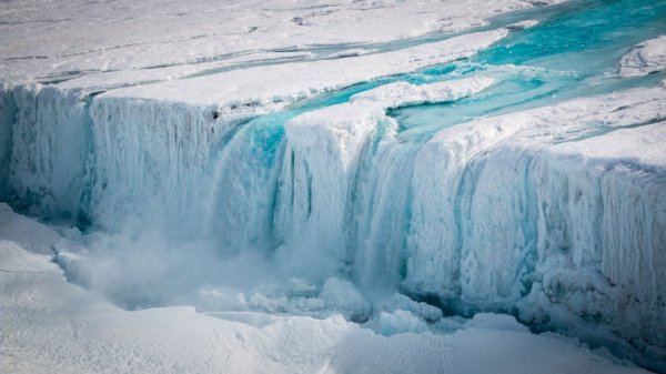
(Surface melt water flooding into a great crack along the Nansen Ice Shelf. Large volumes of melt water flooding into ice shelf cracks forces them to widen even as they dive toward union with the warming waters below. Image source. ESA.)
The Nansen Ice Shelf, before this most recent very large iceberg calving event, was a 10 mile wide and 30 mile long ice shelf that buttressed the Presley and Reeve Glaciers of East Antarctica. It abuts the north side of the Drygalski Ice Tongue, and runs out from Mount Nansen just inland of the coast of Victoria Land, Antarctica. And it’s yet another large shelf of ice that appears to be facing severe weakening as global average temperatures are driven above 1 C warmer than those experienced during the late 19th Century by an ongoing and reckless fossil fuel emission.
Nansen occupies a region of the world that has come under increasingly intense observation due to a number of scientific studies highlighting its accelerating rates of melt and a related risk of rapidly rising global sea levels. Human-forced heating of the world’s ocean has caused waters warm enough to accelerate glacial melt to encroach upon Antarctica from the Southern Ocean. These warmer waters are drawn along beneath the floating ice shelves as fresh melt water flooding out along the ocean surface generates a landward-moving bottom current. These warmer waters eventually push beneath the ice shelves — eating away at their undersides.
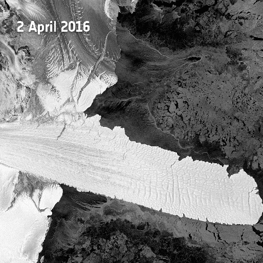
(Massive ice berg breaks away from the Nansen Ice Shelf on April 7th in this ESA satellite shot.)
In West Antarctica, glaciers are seen as especially vulnerable. One region containing the Pine Island and Thwaites glaciers — alone capable of increasing global sea levels by 3-6 feet — is experiencing 3-4 meters of melt along the undersides of ice shelves each year. Meanwhile, the Pine Island Glacier’s grounding line — the point upon which the floating ice shelf is anchored — has retreated more than 31 kilometers further into Antarctica.
As ice shelves and glaciers melt from below, more of the glacial mass is floated away from the main ice mass. And since West Antarctica has a retrograde slope, more warm ocean water comes flooding in beneath the glaciers. As more ice calves off the glacial faces, ice fronts along the ocean become taller. The brittle ice cannot retain structural integrity for long and ever taller ice faces produce swifter and swifter rates of collapse into the ocean. On the surface, warmer conditions cause rivers of melt water to flow into cracks. The extreme weight of the water flooding these cracks serves as a kind of wedge — widening the cracks and shoving sea-facing sections along the cracks into the ocean.

(Though the most rapid rates of glacial melt dominate the Antarctic Peninsula and the region near the Pine Island and Thwaites glaciers, increasing rates of volume loss from Antarctic ice shelves have been creeping into a section of East Antarctica near the Nansen Ice Shelf along the coastline of the Ross Sea [just below where the abbreviation DRY for Drygalski Ice Tongue appears on the map]. With global average temperatures now exceeding 1 C above pre-industrial, we can expect melt and net volume loss to expand along the Antarctic coastline. Image source: Science.)
East Antarctica, a region occupied by Nansen, has been seen as less vulnerable to melt from human-forced warming than West Antarctica and the Antarctic Peninsula. That said, increasing melt rates have progressed on into much of the Ross Sea coastal region. Though the current very large calving event at Nansen appears to have taken place within the expected time-frame (once every 30 years), a context of melt is beginning to encroach. For almost all glaciers along this section of East Antarctica show increasing rates of ice loss.
Links:
Nansen Gives Birth to Two Icebergs
Widespread, Rapid Grounding Line Retreat at Pine Island Glacier
Volume Loss From Antarctic Ice Shelves is Accelerating
Hat Tip to Colorado Bob


robindatta
/ April 25, 2016Crustaceans and cephalopods will soon have opportunities to move into former oceanfront properties as they become “landfront” properties.
LikeLike
dtlange
/ April 25, 2016– Off topic — but a telling figure re fossil fuels.
LikeLike
robertscribbler
/ April 25, 2016I think that gives a pretty clear indication, in microcosm, of what’s wrong with the media coverage of climate change — advertising dollars produce a mixed message together with a serious conflict of interest.
Great graphic here, DT.
LikeLike
dtlange
/ April 25, 2016– Yeah, and talk about a malignant symbiosis which operates at our peril.
– Call you the Post-Man. Thx for your efforts.
LikeLike
Loni
/ April 25, 2016‘Liberating’ the media is a priority.
LikeLike
Aaron Lewis
/ April 26, 2016Yes, and that does not seem to include ads for cars, car products, airlines, vacation resorts. and energy intensive consumer products.
LikeLike
climatehawk1 (@climatehawk1)
/ April 26, 2016As an aside, that is why I think divestment campaigns are a great idea. IMHO, they’re imbalanced in the same way as guerrilla warfare. Fossil fuels companies spend hundreds of millions of dollars each year on image advertising, and grassroots divestment campaigns are a very inexpensive and credible way to whack away at the value of those ads.
LikeLike
robertscribbler
/ April 26, 2016Absolutely. It’s an asymmetrical threat that the current industry power structure has little reliable defense against. It harms industry legitimacy, generates a moral rationale for legal action, and creates this drip, drip, drip of lost investment capital.
LikeLike
Mark from OZ
/ April 26, 2016Or, in the case of Straya, the enormous ‘benefits’ of the black rock (coal). Over 80% of the mining operators are international co’s ( where the revenue goes) and they are shameless in focusing on the local ‘benefits’; jobs, spending, taxes for the nation (as-if: they receive multi-bil $ subsidies which are then used to capture the deeply corrupted pollies to further their interests) and they run these propaganda campaigns because they work; cleverly drawing attention away from the real source.
They don’t give a shiit (ake mushroom) about anything but ‘shareholder value’ and protecting the ‘interests’ of the century old industries and their ‘investment’ and to hear these radio and TV ads during vigorous discussions about the fate of the dying GB reef makes me furious!
LikeLike
dtlange
/ April 25, 2016– Off topic again — re: an effect of recent El Nino’s near miss for a mostly dry Southern California.
– ‘ Cachuma Lake is at 14.7 percent of its overall capacity’ — Cachuma is the major source of water for the area. Gibraltar is the other but is mostly silted up and of minimal use.
Tougher Santa Barbara Drought Restrictions Could Increase Soon
The city Water Resources Division is calling for an increase from a 25 to a 35 percent water savings demand on its customers.
The Santa Barbara City Council will hold a meeting on the water supply issues Tuesday.
There is also a recommendation for a ban on new pool permits and the ban extends to new building permits if there is a net new water use.
The current water year is expected to fall well below the average, and extraordinary actions have been part of the long range drought planning by city leaders.
Cachuma Lake is at 14.7 percent of its overall capacity with a new pumping system in place to bring water from the deeper remaining areas of the lake to the Tecelote Tunnel for use in Goleta, Santa Barbara, Carpinteria and Montecito.
http://www.keyt.com/news/tougher-santa-barbara-drought-restrictions-could-increase-soon/39204468
LikeLike
dtlange
/ April 25, 2016– A little morbid dark comedic relief to the above: ‘As in What’s the Matter with Santa Barbara?’ (Montecito is a nearby and mostly fascist wealth enclave where they buy a lot of water to keep their landscapes green — and who for sure would not be visited by the fracking outfits. No, siree.)
LikeLike
todaysguestis
/ April 25, 2016Siberian erosion, river runoff speed up Arctic Ocean acidification
https://www.adn.com/article/20160424/siberian-erosion-river-runoff-speeds-arctic-ocean-acidification
LikeLike
Loni
/ April 25, 2016Another exceptional report, Robert. I’m assuming you saw the crack at the base of Drygalski Ice Tongue, it is running right in line with the section that just broke off. I suppose the ‘Tongue’ is up on a ridge, or a tight archipelago?
The level of destruction that we are bearing witness to simply leaves one speechless…..meanwhile we are still blessed with the likes of Lamar Smith, Joe Burton and James Inhofe. “Go team” he mutters holding head in hands.
LikeLike
Loni
/ April 25, 2016Having taken a closer look at it, the 40 kilometer crack probably includes that crack in the Drygalski Ice Tongue.
LikeLike
robertscribbler
/ April 26, 2016It’s driven about 1/4 to 1/3 of the way through the ice tongue. Apparently a feature that is at least 4,000 years old.
LikeLike
wili
/ April 26, 2016!
LikeLike
Syd Bridges
/ April 25, 2016The more I see, the more plausible is a multi-meter sea level rise this century. The sliding snow may be little at first, but once it starts the avalanche, its ultimate consequences are devastating.Now we are faced with rapidly increasing melt in both the world’s major ice sheets. If I had beachfront property, I think now would be a very good time to sell it.
LikeLike
redskylite
/ April 25, 2016Off topic but still on ice, the Washington Post had some concern for the faulty satellite sea ice monitoring equipment today. A need to fill the gap to ensure quality continued monitoring.
Now, with no government plans to launch a replacement any time soon, scientists who rely on these satellites for valuable climate data are beginning to worry about the future of their research.
https://www.washingtonpost.com/news/energy-environment/wp/2016/04/25/the-arctic-is-melting-and-scientists-just-lost-a-key-tool-to-observe-it/
LikeLike
redskylite
/ April 25, 2016European Space Agency just launched second Sentinel (1b) satellite – not sure if this can provide the necessary sea-ice measurements. Fingers crossed in hope of repair and resumption.
Sentinel-1B joins its identical twin, Sentinel-1A, in orbit to deliver information for numerous services, from monitoring ice in polar seas to tracking land subsidence, and for responding to disasters such as floods.
http://www.esa.int/Our_Activities/Observing_the_Earth/Copernicus/Sentinel-1/Sentinel-1B_launched_to_complete_radar_pair
LikeLike
Jim Miller
/ April 26, 2016I don’t know how much a satellite build and launch costs but I’m guessing well under a billion dollars. There are hundreds of billionaires in the US alone, many with multiple billions. It is gobsmacking that our society elevates private wealth accumulation over absolutely critical science concerning end-of-civilization conditions.
LikeLike
Paul
/ April 26, 2016I wonder how much energy it takes to research build launch and maintain a satellite to tell us what we already know?
LikeLike
climatehawk1 (@climatehawk1)
/ April 26, 2016Hmmm. Not our society, just the Republican cabal in Congress, many elected in a low-turnout off-year election from severely gerrymandered districts.
LikeLike
climatehawk1
/ April 25, 2016Tweet scheduled.
LikeLike
climatebob
/ April 26, 2016We need to get a consensus by leading cryosphere scientists who can give us an idea of the cumulative contributions to sea level rise and put a time frame together. http://www.climateoutcome.kiwi.nz/latest-posts–news/sea-level-rise-urgency
LikeLike
Ryan in New England
/ April 26, 2016Fantastic job staying on top of so many unfolding events, Robert. Just wonderful. You provide an original narrative concerning very important issues that either get downplayed by the media or ignored all together. You put the situation into the proper context, and explain how each new post is just one piece in the larger mosaic that is our rapidly changing world. Pulling together data from different sources and synthesizing it into a neat, coherent and enjoyable read.
That said, here we are taking another step toward a dystopian future with a wrecked climate. You pointed out that this crack was just beginning in 1999 and the rate of calving is about expected. Is it still worrying that this is occurring in East Antarctica, an area currently less susceptible to melt than West Antarctica? Could this be the start of greater melt and more rapid discharge in East Antarctica?
LikeLike
robertscribbler
/ April 26, 2016The large crack near the coastline in the adjacent ice tongue is a concerning feature to me. Volume losses in this zone appear to be picking up. So some of the more fragile features may go into destabilization soon.
LikeLike
Ed-M
/ April 27, 2016Like the tongue. I bet it’s a sanctuary for penguins, noting it extends so far out into the sea like that. 😦
Thanks for keeping up with all this Robert. 🙂 I certainly can’t. 😦 😦
LikeLike
robertscribbler
/ April 26, 2016Ryan — just so you know, I get typos fixes all the time. I really appreciate the second set of eyes.
Best
–R
LikeLike
Jay M
/ April 26, 2016lazy jetstream
LikeLike
dtlange
/ April 26, 2016LikeLike
Greg
/ April 26, 2016Jeff Masters weighs in. Hell is coming to breakfast today.
https://www.wunderground.com/blog/JeffMasters/busy-week-of-severe-weather-ahead-for-nations-midsection
LikeLike
dtlange
/ April 26, 2016LikeLike
dtlange
/ April 26, 2016– Action oriented piece here:
4/25/2016 Wisconsin
Michael Mann: Man-made climate change is real
The debate should focus on what to do about it
The famous climate scientist Dr. Michael Mann has a simple, straightforward message for everyone: manmade climate change is real and significant, and the real debate should focus on solutions to problematic global warming, where he says a range of prescriptions should be on the table.
http://www.rivernewsonline.com/main.asp?SectionID=6&SubSectionID=59&ArticleID=72388
LikeLike
dtlange
/ April 26, 2016LikeLike
climatehawk1 (@climatehawk1)
/ April 26, 2016Scheduling tweet on this. Thanks, DT.
LikeLike
dtlange
/ April 26, 2016– USA – Solar Panels – Prince
LikeLike
wili
/ April 26, 2016+1
LikeLike
Colorado Bob
/ April 26, 2016Researchers discover fate of melting glacial ice in Greenland
Date:
April 25, 2016
Source:
University of Georgia
Summary:
A team of researchers has discovered the fate of much of the freshwater that pours into the surrounding oceans as the Greenland ice sheet melts every summer. They were surprised to discover that most of the meltwater found off the west coast of Greenland actually originated from ice on the east coast. Meltwater originating from the west coast of Greenland, on the other hand, is often kept pinned to the coastline by strong winds, which push it northward toward Baffin Bay.
https://www.sciencedaily.com/releases/2016/04/160425141518.htm
LikeLike
Jim Miller
/ April 26, 2016I’m surprised builders from Florida aren’t planning to put up expensive condos on the berg.
LikeLike
Colorado Bob
/ April 26, 2016Because the House of Suad has bought them , to tow them to Arabia.
LikeLike
Colorado Bob
/ April 26, 2016India –
Deadly summers claiming more lives each year
Last year alone, heat wave killed at least 2,500 people — a 50 per cent increase compared to 2014.
Deaths due to extreme summer temperatures have seen a sharp upturn in recent years. Last year alone, heat wave killed at least 2,500 people — a 50 per cent increase compared to 2014. This year seems no different, with the India Meteorological Department predicting an average increase of 1 degree Celsius during summer.
We are still 20-30 days away from the peak summer phase and already over 160 have died, with the worst-hit being Andhra Pradesh, Telangana and Odisha. There are ominous signs of a torrid summer ahead of us — some States have reported an increase in temperature of about 4-5 degrees Celsius for April.
Link
LikeLike
climatehawk1 (@climatehawk1)
/ April 26, 2016Nice catch, scheduling tweet.
LikeLike
Colorado Bob
/ April 26, 2016Extreme Weather Kills 13, Destroys Hundreds of Pagodas
RANGOON — Gale-force winds and hailstorms have killed more than 10 people and destroyed homes, religious buildings and livestock in northern Burma since Friday.
The affected areas were in Mandalay, Sagaing and Magwe divisions, as well as Shan and Arakan states, claiming the lives of 13 people and injuring dozens. Storms damaged more than 15,000 homes and killed hundreds of cattle, local media reported on Monday.
According to a report on Saturday from the office of Burma’s military commander-in-chief, a 30-minute-long gale-force wind toppled more than 800 pagodas in the Kakku Pagoda compound about 30 miles outside of Taunggyi, the capital of Shan State. The pagoda complex boasts a cluster of more than 2,400 religious structures, believed to be many centuries old.
Link
LikeLike
dtlange
/ April 26, 2016– Beaufort Sea ice April1 vs April 24 — Topical for Robert’s previous post but I now put it up here:
LikeLike
Colorado Bob
/ April 26, 2016Be nice to know the context , is this the mouth of river ? Because if it is that ain’t good.
LikeLike
Oldhippie
/ April 26, 2016Mckenzie River. The river is still frozen, should be open shortly. The Beaufort ice movement is due to a large strong high pressure system and attendant winds. Mckenzie water will melt even more ice.
LikeLike
dtlange
/ April 26, 2016– Thanks for the location, Oldhippie.
LikeLike
dtlange
/ April 26, 2016– AU – Fossil fuel subsidies
A diverse group of religious, education and renewable energy sector leaders have gathered in Canberra to pressure Scott Morrison to cut $7.7bn worth of subsidies for fossil fuels in the budget
The coalition, organised by climate change advocacy group 350 and WWF, says as the government seeks to tackle the deficit community pressure is building to cut fossil fuel subsidies and invest instead in areas including health and renewable energy.
http://www.theguardian.com/environment/2016/apr/26/scott-morrison-faces-pressure-to-cut-77bn-fossil-fuel-subsidies
LikeLike
Phil
/ April 26, 2016While their attempt is good, it will not affect the current Government.
Many of its clowns (oops ministers) have been running around saying that climate science has not been settled or thinking of ways to rip off the bottom 98 per cent for the top 2 per cent.
LikeLike
Josh
/ April 26, 2016All the more reason for more and more of these type of actions then. Government not listening simply shouldn’t be acceptable.
LikeLike
Colorado Bob
/ April 26, 2016Flora & fauna perish in Kumaon forest fires
Pithoragarh, April 25
Forest animals and reptiles are dying in the Kumaon region following forest fires and the Forest Department is helpless in extinguishing the fires due to shortage of workers and inadequate preparations as the fire season started a month before expected this year.
According to sources from Bageshwar, all six ranges of forest division in the district are under fires which is causing loss worth crores of rupees to forest assets.
Forest officials confirmed that animals were running towards the human settlement due to these fires which has engulfed all six ranges of Kapkot, Kanda, Rima, Banlekh, Garur and Kausani. “Though we have prepared the plan, due to lack of workers, we could not do so as all our employees are above 55 years of age and cannot be deputed in interior ranges,” said MB Singh, DFO, Bageshwar.
Link
LikeLike
Colorado Bob
/ April 26, 2016Aqua/MODIS
2016/111
04/20/2016
11:50 UTC
Phytoplankton bloom in Lake Kiva, central Africa
LikeLike
Colorado Bob
/ April 26, 20164 days before –
Terra/MODIS
2016/101
04/10/2016
08:15 UTC
Phytoplankton bloom in Lake Kiva, central Africa
LikeLike
Colorado Bob
/ April 26, 2016Sorry wrong keystroke. This one is 10 days earlier. Gonna look up the of this size of this thing. Here’s one from the 18th –
Aqua/MODIS
2016/109
04/18/2016
12:05 UTC
Phytoplankton bloom in Lake Kiva, central Africa
LikeLike
Colorado Bob
/ April 26, 2016The lake covers a total surface area of some 2,700 km2 (1,040 sq mi) and stands at a height of 1,460 metres (4,790 ft) above sea level. Some 1 370 km2 or 58 percent of the lake’s waters lie within DRC borders. The lake bed sits upon a rift valley that is slowly being pulled apart, causing volcanic activity in the area, and making it particularly deep: its maximum depth of 480 m (1,575 ft) is ranked eighteenth in the world.
https://en.wikipedia.org/wiki/Lake_Kivu
I find these images really really creepy.
Chemistry
Lake Kivu is a fresh water lake and, along with Cameroonian Lake Nyos and Lake Monoun, is one of three that experience limnic eruptions. Around the lake, geologists found evidence of massive biological extinctions about every thousand years, caused by outgassing events.
LikeLike
Colorado Bob
/ April 26, 2016I find these images really really creepy.
LikeLike
Colorado Bob
/ April 26, 2016The risk from a possible Lake Kivu overturn is catastrophic, dwarfing other documented lake overturns at Lakes Nyos and Monoun, because of the approximately two million people living in the lake basin.
LikeLike
Colorado Bob
/ April 26, 2016The approximately 500 million tonnes of carbon dioxide in the lake is a little under 2 percent of the amount released annually by human fossil fuel burning.
LikeLike
Colorado Bob
/ April 26, 2016This problem associated with the prevalence of methane is that of mazuku, the Swahili term “evil wind” for the outgassing of methane and carbon dioxide that kills people and animals, and can even kill vegetation when in high enough concentration.
I find these images really really creepy.
LikeLike
Greg
/ April 26, 2016Not to be confused with Mazungu. The word Muzungu comes from Kiswahili, where ‘zungu’ or ‘zunguka’ is the word for spinning around on the same spot. That dizzy lost look was perfected by the first white people arriving in the African Great Lakes. Muzunguzungu is Kiswahili for a dizzy person.
LikeLike
Colorado Bob
/ April 26, 2016Something is feeding this bloom , and it’s not good. I never heard of this lake before an hour ago.
Mother nature never gave up her vote just because Henry Ford invented the model “T”.
I wonder what we will do when she starts throwing real fast balls at us.
LikeLike
Colorado Bob
/ April 26, 2016Read the Wiki link . To see it all turn a really strange shade of turquoise in 3 weeks. . Means a special plankton is at work.
LikeLike
Colorado Bob
/ April 26, 2016At Lake Nyos, Haraldur Sigurdsson, a scientist sent in by the United States government to make sure this mysterious phenomenon was not the result of biological warfare, said: “I realized that the only explanation that was viable was the carbon dioxide burst.” He and his team concluded that a landslide had likely triggered the limnic overturn: Rocks from nearby mountains crashed into the lake, penetrating its deepest layers and disturbing the delicate balance of gasses. The water foamed and spouted up out of the lake, effervescent and deadly; the resulting cloud of gas traveled fast enough that the villagers who died did so quickly and quietly. In the lakeside town of Nyos, only six people survived that night. Because CO2 is denser than air, it hugged the ground in low-lying clouds and killed the villagers while they slept, like a malevolent blanket. “The thing was white, white like cloth,” a resident said. “It didn’t go up in the air, it mostly went down near the ground.” The lake had exploded.
Death by carbon dioxide poisoning is a result of lack of oxygen in the blood. The body starts to shut down in stages; the victim grows disoriented and panicky and and may start to experience seizures. The victim’s organs start to shut down as oxygen becomes unavailable; at Lake Nyos, death would have come almost immediately. The dead and the living alike were found with burn-like lesions on their skin, and the six who survived reported symptoms from limb weakness to nausea to survivor’s guilt. The CO2 had induced comas in many survivors. The lesions mostly went away after a couple of weeks.
Lake Nyos covers roughly 1.5 square kilometers; Lake Kivu, 2,700. Two million people live on its shores. The scale of disaster there would be exponential compared with what happened at Nyos — potentially greater, even, than the death toll of the Rwandan genocide, which is estimated to have taken between 800,000 and one million people.
https://psmag.com/is-lake-kivu-set-to-explode-bf8d6bedc876#.161y86ea0
LikeLike
Syd Bridges
/ April 26, 2016Thanks for this article, CB. I guess that anywhere that vulcanism meets deep water, there is the potential for this build-up of dissolved CO2. So “Lake Nyoses” might not be uncommon. Also, it can build up in craters on volcanoes, or in limestone caves, or even in badly ventilated beer cellars. I heard about the pipes in Lake Kivu some years ago, and whilst extracting and utilising the methane makes sense, both economically and environmentally, the CO2 seems to me by far the greater hazard. Methane is light and it rises, whereas CO2 is dense and stays close to the ground. Perhaps the profits from the methane extraction could be used to enhance CO2 degassing, or would that be too much to ask?
LikeLike
Witchee
/ April 26, 2016On Mammoth Mountain in CA trees (and even 3 members of the ski patrol in 2006), die from CO2 seeping from the Long Valley Caldera. http://pubs.usgs.gov/fs/fs172-96/
LikeLike
Colorado Bob
/ April 26, 2016I find these images really really creepy.
LikeLike
robertscribbler
/ April 26, 2016There’s some conjecture and speculation about what’s going on here. There’s been some recent volcanic activity in the region, however, there are at least a few reports that the color change is due to a phenomena called lake whitening.
http://ktpress.rw/2016/04/why-is-lake-kivu-changing-colours/
Increases in CO2 in the lake can generate algae blooms. But apparently a surface stratification in a calcium carbonate rich lake like this one can cause a torquoise or white color to emerge as the carbonate precipitates out.
Haven’t had much solid confirmation on either report. But, to my knowledge, there is no direct observation of increased CO2 or methane entering deeper portions of the lake at this time.
LikeLike
Abel Adamski
/ April 26, 2016That Drygalski tongue would have to impact ocean circulation currents in the area, I wonder what the consequences would be if it broke off at the growing crack and just how large the resultant iceberg would be. ?
LikeLike
wili
/ April 26, 2016Again, a wonderfully composed and utterly stunning piece.
The one thing that might make it even more accessible is some clearer guide to the bewildered on where exactly Nansen and its neighboring features are. Perhaps at least indicating in the comment on the last map that “DRY” indicates where the Drygalski Ice Tongue is (assuming I have that right). This stuff is too important for people to pass over because they can’t figure out where on the map the action is. (But then I might be rather in the minority in my map/geography obsessions! 🙂 )
LikeLike
Kevin Jones
/ April 26, 2016Hey, wili. The location is in the ESA link under that fantastic photo of the waterfall. I was curious about the scale. The ESA link says the shelf is 250m to 260m thick. 1/8 of an (evenly shaped) berg floats above sea level. We’re looking at something around a 32.5 meter–106 foot tall waterfall. How’s THAT for scale?
LikeLike
Kevin Jones
/ April 26, 2016Yes. “DRY” is Drygalski.
LikeLike
wili
/ April 26, 2016Cool, KJ. Thanks. I did eventually figure it out myself, but it took a bit of digging (which never hurt anyone, of course! ‘-) ).
LikeLike
robertscribbler
/ April 26, 2016Added changes. Thanks, Wili.
LikeLike
jasonmakeig
/ April 26, 2016SO is anybody doing anything concrete about the problem????? chrs fr Australia
LikeLike
wili
/ April 26, 2016These folks seem to have the idea: https://newmatilda.com/2016/04/24/sketching-the-fight-bill-mckibben-on-how-to-take-down-the-fossil-fuel-companies/
“Sketching The Fight: Bill McKibben On How To Save The Planet”
“In the ‘dark shadow of what’s happened in the Great Barrier Reef,’ prominent climate activist Bill McKibben has urged Australians to join in plans to shut down the world’s largest coal port in Newcastle this May”
LikeLike
robertscribbler
/ April 26, 2016Great work here. Let’s hope Australia gets a much needed change of government soon.
LikeLike
Vic
/ April 26, 2016Climate related cracks appearing in our consumer driven economy.
A class action hearing has begun against Scenic Tours on behalf of 1,265 passengers who had their European cruises interrupted by river flooding in May and June 2013.
“The minute you step on board… you’ll be immersed in all-inclusive luxury,” the advertisement stated. Then the rains came.
http://www.abc.net.au/news/2016-04-26/luxury-river-cruise-holiday-like-backpackers-tour-court-told/7358206
LikeLike
dnem
/ April 26, 2016I heard this piece on NPR a few days ago and it resonated with me.
http://www.npr.org/sections/thetwo-way/2016/04/20/474690481/climate-change-some-people-may-not-be-sweating-it-because-the-weather-is-nicer
I am very interested in how public perceptions about climate change are formed and I often worry that many people are enjoying our freakishly mild winters, which have actually warmed more than our summers. “Hey, this global warming stuff ain’t so bad, huh?” they joke, lazing in the park in January. The linked piece confirms this idea. The research is behind a paywall in Nature.
LikeLike
robertscribbler
/ April 26, 2016I think concern is growing, especially among those who live on the coast. I’ve got a lot of friends and family in VA Beach and Norfolk who are increasingly worried.
In any case, come summer those summer like January days can become 110 and 120 degree July and August days, record drought days, record wildfire days, record hail days and record flood days.
Recent polls seem to be weighing heavily on the side of climate change belief rather than non-belief these days.
LikeLike
Robert in New Orleans
/ April 26, 2016Robert, with the increasing torrent of climate change news (pun intended), maybe the time has come to add semi regular blog posts focused about different aspects of climate change such as sea level rise, severe weather, economic disruption, etc. It is just a thought.
LikeLike
robertscribbler
/ April 26, 2016We cover drought, extreme weather, sea level rise, Arctic and Antarctic ice melt, mass casualties due to extreme weather, mass migration, cutting edge science, global temperature increase, renewable energy and fossil fuels, and the occasional politics.
If you look through the over 880 articles written so far, I’m certain you will find a good number on each of those subjects you listed.
LikeLike
Robert in New Orleans
/ April 26, 2016Robert, I must apologize for the imprecision of my statement. What I was referring to would be making blog topics correspond to a semi organized schedule and by that I mean Saturdays blog might be about sea level rise, Wednesday might be about extreme weather and so on. This way if a reader was interested in blogs and comments about a particular subject they could focus on a specific day.
LikeLike
robertscribbler
/ April 26, 2016That’s a good suggestion. The problem is that events of importance tend to pop up in a chaotic fashion and adhering to such a set schedule would degrade my ability to respond to such events in a timely fashion. In other words, I doubt climate change would oblige itself to fit into my schedule. I need to remain nimble and keep a weather eye to what’s going on in real time. You sacrifice some organization for this. But so be it.
LikeLike
climatehawk1 (@climatehawk1)
/ April 26, 2016If readers are interested in a particular topic, the stuff I tweet is posted to a (public) Facebook group and then organized by topical thread (health impacts, sea level rise, sea ice, etc.). You can request admission at https://www.facebook.com/groups/1475938476062342/ . Odds are it will be granted, since I am the group administrator.
LikeLike
climatehawk1 (@climatehawk1)
/ April 26, 2016Here’s a different take on the “pleasant weather” study–seems it omitted extreme weather events: https://medium.com/@huntercutting/pleasant-weather-through-a-glass-darkly-10b3686e8412#.w0qsh5lx5
LikeLike
Caroline
/ April 26, 2016Hopefully this isn’t one of Obama’s policies Hillary Clinton wants to “continue and support” (although given her support for fracking, it is doubtful she will vehemently oppose this, as she should):
Offshore Shilling
An analysis of the economic studies justifying the Department of Interior’s offshore drilling plan
April 2016
The federal government is relying on economic predictions heavily influenced by the oil and gas industry as justification for its proposed offshore drilling program.
http://public-accountability.org/2016/04/offshore-shilling/
There is something we can all do—-not vote for officials who take money from the fossil fuel industry and as such are beholden to them. We must not elect officials who support fracking, drilling, polluting. We must work for candidates who will do everything possible to fight climate change (including a tax on carbon even though that’s not the ultimate solution)
LikeLike
robertscribbler
/ April 26, 2016Well, I don’t think we can honestly say that she supports fracking. More that, given her language on the campaign trail, she might look the other way rather than directly oppose it as often as Bernie would. But there’s a difference between that and a wholehearted support of the practice. I think you might, as we’ve seen with Obama, find support for FF industry in some areas and opposition in others. For my part, I view these as half measures and backsliding. But we should also be very clear that under Obama, carbon emissions from the US have dropped, coal is on its way out, and renewables have seen a renaissance like never before.
I’ll be voting for Bernie today in the MD primary as I think he’s the best RE climate, the economy, and a host of other issues. I urge everyone here to do the same. But if Hillary wins, I will wholeheartedly support her against the wind-killing, anti everything I agree with, Trump. And no, I will not fall for appeals to throw my vote away to a third party candidate. This election is far too important.
But let’s be clear. We shouldn’t give up on Bernie. But we should also allow ourselves to see with eyes unclouded.
LikeLike
June
/ April 26, 2016It is frustrating that most of the mainstream media media have practically anointed Hilary when the polls continue to show Bernie would beat Trump by a much bigger margin than Hilary.
Sanders Still Strongest Candidate as New Poll Shows Trump and Clinton in Near-Tie
“According to the latest George Washington (GW) University Battleground Poll, Clinton’s lead over Trump has shrunk to 3 percentage points, with her besting the billionaire developer by just 46 to 43 percent nationally. What’s more, the poll has a margin of error of plus or minus 3.1 percentage points.
The RealClearPolitics average has the former secretary of state with a slightly higher lead (8.5 percent) over Trump.
Meanwhile, Sanders continues to trounce Trump by double digits: 51 to 40 percent in the GW poll, and 53 to 37.8 percent, according to RealClearPolitics.”
http://commondreams.org/news/2016/04/25/sanders-still-strongest-candidate-new-poll-shows-trump-and-clinton-near-tie
LikeLike
robertscribbler
/ April 26, 2016Yeah. That’s frustrating to me as well. Although it was always going to be a heck of slog for Sanders in this race. Hillary has a pretty massive influence. It’s honestly a big surprise that Obama managed to beat her in 2008.
LikeLike
climatehawk1 (@climatehawk1)
/ April 26, 2016Hear, hear! Voted for Bernie, contributed to his campaign. Will vote for Hillary if she is the nominee. Way too much at stake to sit on our hands.
LikeLike
Greg
/ April 26, 2016Could be a big Hail day in the Plains. It seems to be getting bigger too.
LikeLike
Caroline
/ April 26, 2016“The north pole is moving—there are two main causes: The Greenland and West Antarctic ice sheets are melting, and our global water supply is drastically shuffling all around. Thus, human-caused disturbances are literally causing changes in the planet’s poles.”
http://futurism.com/north-pole-moving-now-know-whats-causing-us/
LikeLike
robertscribbler
/ April 26, 2016This article is more than a bit irresponsible in that it hasn’t noted the rate of polar drift due to mass change. In this Nature study we find that the rate of drift is about 6 centimeters per year. If this drift continued, it would take 100,000 years for the pole to shift 60 kilometers.
http://www.nature.com/news/polar-wander-linked-to-climate-change-1.12994
However, due to the fact that mass change is generating a new gravity/mass balance for Earth, the drift would only tend to continue for as long as ice melt at the poles continued. A period that is likely to last for decades or Centuries. Given these constraints, polar drift is not likely to exceed a handful of kilometers over the long term.
The fact that we observe drift now is moreso proof of the geophysical changes we are in the process of triggering here on Earth. The big impact to human beings and to life here will come from sea level rise and a related increased stratification of the oceans as glacial melt ramps up. Cutting fossil fuel emissions as swiftly as possible is the best way to limit this harm.
LikeLike
Abel Adamski
/ April 27, 2016R.S thank you for your excellent posts, as stated above it is the daily come to site.
In relation to ocean stratification an interesting note from the past
During the 50’s the US military tested a depth bomb – a nuclear depth charge. Several months later a research vessel went back into the area to take water samples, see what had happened to the blast products.
They found they had spread out over (if I recall correctly) around 100 sq kilometers. But they were only in a layer a meter or so thick! Even after a nuclear blast, the strong stratification of the oceans had enforced a layering of the movement of the blast products.
And a scientist on the ship? Revelle.
LikeLike
robertscribbler
/ April 27, 2016Thanks for this tidbit, Abel.
For those not familiar, Revelle was a giant in the Earth and ocean sciences. He was a contemporary of Keeling and was very influential at SIO. He was a mentor to Al Gore and an advocate of action to mitigate global warming back in the 1980s and early 90s before his death in 91. He was also mischaracterized by Fred Singer in an attempt to throw doubt on the dangers of human-forced warming.
https://en.m.wikipedia.org/wiki/Roger_Revelle
LikeLike
Abel Adamski
/ April 27, 2016Sorry the link
https://theconversation.com/us-firms-knew-about-global-warming-in-1968-what-about-australia-57878#comment_953398
That truly was a fascinating conversation, such a high calibre of comments, so much was being done in the 50’s to the 80’s then neoliberalism and privatisation brought so much to a screeching halt especially in Australia
LikeLike
Robert in New Orleans
/ April 26, 2016Another example of insanity:
The siting board signed off on the two controversial lines and a backup plan in May 2014 as part of an approval for two proposed new nuclear reactors at Turkey Point.
Read more here: http://www.miamiherald.com/news/local/environment/article72863687.html#storylink=cpy
Just about everything I have read about future potential sea level rise indicates that Florida Power & Light should be making long term plans about closing and decommissioning the plants existing two reactors.
LikeLike
Andy in SD
/ April 26, 2016I read that they have problems (big) with the cooling canals right now. More heat generated may not be wise.
LikeLike
Robert in New Orleans
/ April 26, 2016My understanding is that all sea shore located nuclear power plants should be looking now at shut down and decommissioning procedures due to the long lead times involved in this process. We just don’t know about the rate of future sea level rise, there could be 5 inches or 25 inches of rise by 2050.
LikeLike
robertscribbler
/ April 26, 2016Absolutely. All it takes is one big storm in the wrong place and we’ve got a Fukushima-type problem on the US East Coast now. The risks increase going forward, but even now the risk is certainly not zero and those sites grow more and more vulnerable with each passing year.
I am off to vote now. Will be back to hopefully finish another article soon. Big storms across the eastern half of the US popping up as we speak!
Best to all and thanks so much to you guys for the relevant articles, the brilliant discussion, and the suggestions.
Best
–R
LikeLike
Robert in New Orleans
/ April 27, 2016April 26, 2016 is the 30th anniversary of Chernobyl Nuclear Accident.
If this doesn’t make you ill after reading it, you have a strong stomach:
http://chernobylgallery.com
LikeLike
dtlange
/ April 26, 2016– USA – VA – SLR – A bit odd here: Virginia Shoreline Resiliency Fund [with no funding]
Virginia establishes fund to help with sea-level rise
RICHMOND — Virginia has set up a new revolving loan fund designed to help property owners prepare for rising sea levels.
But the Virginian-Pilot (http://goo.gl/D9noXp ) reports that the fund has no funds and may not have any money for several years.
Still, Virginia Shoreline Resiliency Fund supporters say the program puts Virginia at the forefront of preparing for ways to help homeowners and businesses with rising sea levels.
http://www.richmond.com/news/virginia/ap/article_6823e446-96d8-5ef6-b33a-528e34472e7f.html
LikeLike
dtlange
/ April 26, 2016– CO2 Threat – More evidence Exxon/Imperial Oil knew:
““Since pollution means disaster to the affected species, the only satisfactory course of action is to prevent it…”
[This has also been the thrust of my arguments regarding (low altitude) ‘air pollution’.]
-DeSmogblog 0426
“There is no doubt”: Exxon Knew CO2 Pollution Was A Global Threat By Late 1970s
Throughout Exxon’s global operations, the company knew that CO2 was a harmful pollutant in the atmosphere years earlier than previously reported.
DeSmog has uncovered Exxon corporate documents from the late 1970s stating unequivocally “there is no doubt” that CO2 from the burning of fossil fuels was a growing “problem” well understood within the company.
“It is assumed that the major contributors of CO2 are the burning of fossil fuels… There is no doubt that increases in fossil fuel usage and decreases of forest cover are aggravating the potential problem of increased CO2 in the atmosphere. Technology exists to remove CO2 from stack gases but removal of only 50% of the CO2 would double the cost of power generation.” [emphasis added]
– Those lines appeared in a 1980 report, “Review of Environmental Protection Activities for 1978-1979,” produced by Imperial Oil, Exxon’s Canadian subsidiary.
…
“Since Pollution Means Disaster…”
A document discovered by DeSmog reveals that Exxon was aware as early as the late 1960s that global emissions of CO2 from combustion was a chief pollution concern affecting global ecology.
Those details were found in a 1970 report, “Pollution Is Everybody’s Business,” authored by H.R. Holland, a Chemical Engineer responsible for environmental protection in Imperial Oil’s engineering division. [click to download PDF of “Pollution is Everybody’s Business]
Holland wrote:
“Since pollution means disaster to the affected species, the only satisfactory course of action is to prevent it – to maintain the addition of foreign matter at such levels that it can be diluted, assimilated or destroyed by natural processes – to protect man’s environment from man.”
http://www.desmogblog.com/2016/04/26/there-no-doubt-exxon-knew-co2-pollution-was-global-threat-late-1970s
LikeLike
dtlange
/ April 26, 2016– Pdf of Exxon/Imperial Oil document:
Click to access DeSmogBlog-Imperial%20Oil%20Archives-Review%20Environmental%20Activities-1980.pdf
LikeLike
dtlange
/ April 26, 2016– This is an example of the mechanics of pure evil — or am I just being old fashioned?
LikeLike
dtlange
/ April 26, 2016– USA – OK KS TX – Severe weather 0426:
Aircraft Removed From Kansas Military Base Ahead of Expected Severe Weather Outbreak; Schools Close in Oklahoma City
Millions of residents in the Great Plains are preparing for a severe weather outbreak that has the potential to leave widespread damage in its path, and even the military is making preparations.
At McConnell Air Force Base in Wichita, Kansas, planes were removed due to the high possibility of damaging storms, the Associated Press reported. Spokesperson Colby Hardin told the AP the planes were being sent to military bases in Spokane, Washington, and Grand Forks Air Force Base in North Dakota.
The storms began Tuesday morning with a hailstorm in the Kansas City metro that dumped hail at the airport. Social media documented the hailstorm, which left hail as big as golf balls in parts of the Kansas City area.
https://weather.com/storms/severe/news/plains-severe-weather-outbreak-impacts
LikeLike
dtlange
/ April 26, 2016– USA – OK KS TX – Severe weather – $$$ – 0426:
– Insurance Journal
– [A.M. Best Company provides news, credit ratings and financial data products and services for the insurance industry.]
A.M. Best: Texas Hail Storm Damage Poised to Exceed 9-Year U.S. Average
A.M. Best says year-to-date 2016 results in Texas alone appear to have already met the nine-year average for hail storm damage in the United States.
According to Best’s Briefing, titled, “Texas Hail Storm Damage Poised to Exceed Nine-Year Average—And It’s Only April,” data compiled from numerous sources states that total hail damage in the United States in 2015 was below the nine-year average of $1.2 billion.
http://www.insurancejournal.com/news/southcentral/2016/04/26/406485.htm
LikeLike
dtlange
/ April 26, 2016https://twitter.com/BloombergCA/status/725021783729029121
LikeLike
dtlange
/ April 26, 2016‘Exxon Mobil loses top credit rating’ should be attached to the above Exxon/Imperial Oil links.
LikeLike
dtlange
/ April 26, 2016LikeLike
Abel Adamski
/ April 27, 2016An interesting read
https://www.theguardian.com/science/political-science/2016/apr/26/abandon-hype-in-climate-models#comment-73141634
he scenarios modelled for the IPCC’s Fifth Assessment Report assume the large-scale deployment of technologies that achieve negative emissions that draw down carbon dioxide from the atmosphere and permanently store it. But whether such proposed methods could be deployed at a material scale is unproven. It would be more prudent to exclude these techniques from mitigation scenarios used by the IPCC, unless and until we have sufficient evidence of their availability and viability to support their inclusion.
Most of the modelled emissions pathways limiting warming to 2 °C (and all the ones that restrict the rise to 1.5 °C) require massive deployment of Biomass Energy with Carbon Capture and Storage (BECCS). This involves growing biomass which is used to generate power and geologically sequestering the carbon dioxide produced. While the constituent steps of this process have been demonstrated, there are but a few, small, examples of the combined process. To rely on this technique to deliver us from climate change is to demonstrate a degree of faith that is out of keeping with scientific rigour.
Alert whilst very valid points, the Author does have vested interests
Tim Kruger is also the head of a company developing a negative carbon technology using natural gas as the fuel
LikeLike
Abel Adamski
/ April 27, 2016Another interesting read focussing on the effects of climate change on New Mexico
http://blog.ucsusa.org/jason-funk/climate-change-new-mexico
A must read
LikeLike
Ed-M
/ April 27, 2016Reblogged at http://twentysixteenisstrange.blogspot.com/2016/04/east-antarctica-beginning-to-melt-like.html with this starter comment:
“This is not good news. I certainly did not expect to see photos of ice-melt runoff in that place, even in its West End, like this this so soon.”
LikeLike
Exposing the Big Game
/ May 3, 2016Reblogged this on Exposing the Big Game.
LikeLike
ClimateState (@climatestate)
/ September 27, 2016LikeLike