Area Burned in Severe Northwest Territory Wildfires Doubles in Just One Day

In just one day, an area of land covering 1,860 square miles of the Northwest Territory has burned. That’s a zone 50 percent larger than the entire state of Rhode Island going up in smoke over just one 24 hour period. And as you can see from the GOES satellite animation below, the volume of smoke being produced by fires burning in a permafrost thaw region is quite extreme:

https://twitter.com/DanLindsey77/status/897485241413251074

*****

Over the past week, the Arctic and sub-Arctic Northwest Territories (NWT) of Canada have been baking under an intense late-summer heatwave. At a time when NWT temperatures should be cooling down from July peaks, most days of the past seven have seen the mercury rise into the upper 80s and lower-to-middle 90s (Fahrenheit).

These 10-35 degree (F) above average temperatures sweltered coniferous forests, peat bogs and thawing permafrost. The high temperatures also unleashed Arctic and sub-Arctic thunderstorms. A new breed of weather for this typically cool zone. One that has been enabled by a human-forced warming of our world through fossil fuel burning — causing temperatures in the Arctic to warm twice as fast as the rest of the globe.

(Extreme heat in the range of 95 degrees F [35 C] blankets the Northwest Territories on August 11, 2017 — drying vegetation and promoting wildfire producing lightning strikes. Image source: Earth Nullschool.)

As lightning strikes rained down over forests and peatlands unprepared for such intense warmth and energy, large fires began to spark. These fires were not yet as visible from the satellite as their, at the time, larger British Columbia brethren (lower left in the image below). But they were in a far northern region that has a recent if rather anomalous history of rapid fire expansion. And already, wispy plumes of smoke were becoming visible even in the wider-angle satellite shots.

Up until August 7th, fires in the Northwest Territory region of Canada had been a bit moderate compared to recent years. In total, about 330,000 hectares had burned throughout 2017. This put the region slightly above the 25 year average for fires, but well behind the more intense rates of burning seen in recent years. As of yesterday (August 14th), this number had climbed to 442,000 acres — exceeding the 15 year average, but still behind the more intense 5 year average.

(Intense Northwest Territory Wildfires begin to spark on August 7th of 2017. These fires are visible near center frame. Note intense fires burning in British Columbia at lower left. For reference, bottom edge of frame is approx 1,200 miles. Image Source: NASA Worldview.)

At this time, however, the satellite imagery was starting to look quite ominous (see image below). Very large and intense rings of fire were starting to expand north of Uranium City. And these fires were casting vast thick and inky plumes of smoke up and over much of Northern Canada. Their visible size and intensity hinted that something pretty extreme was happening on the ground.

As the fires appeared to explode in size, the various wildfire monitors began to check in. In just one day, according to the most recent NWT Current Fire Situation Report, these massive fires more than doubled the total amount of land burned with 924,000 hectares now listed as consumed. This is roughly 3,565 square miles — or about the size of Delaware and Rhode Island combined. With an area fifty percent larger than the size of Rhode Island (1,860 square miles) being consumed in just one day.

(Very intense wildfires burning on August 14 rapidly expanded to consume a section of territory larger than Rhode Island in just one day. For reference, bottom edge of frame is approx. 1,000 miles. Image source: NASA Worldview.)

Meanwhile, land area burned for the Northwest Territory is now above the 5 year average. With these fires burning so intensely, and with hot conditions still on tap for next 48 hours, this already large burn area could continue to rapidly expand.

Much of this burning is occurring along a vast line of wildfires stretching for 200 miles south of Great Slave Lake. In other words, this is a fire line long enough to stretch the distance between Norfolk, Virginia and Myrtle Beach, South Carolina. And the very dense smoke plumes being emitted by these amazingly large fires are likely to ultimately encircle the globe.

(Two hundred mile line of fires south of Great Slave Lake has completely blocked out satellite visual of the lake from orbit. Image source: NASA Worldview.)

Rainfall and cooler conditions by Friday might tamp down these blazes. But the situation at this time appears to be quite severe. Thankfully, unlike the terrible fires that have consumed hundreds of homes and forced tens of thousands to evacuate in British Columbia this summer or the Fort McMurray Fire of 2016 which forced the emptying of an entire city, these massive Northwest Territory fires are presently burning in remote areas.

However, the rapid expansion, large size and vast smoke plumes of these fires bear a grim testament to the fact that the fire regime has vastly changed for the worse in the Arctic nation of Canada. A situation that will continue to dramatically intensify so long as fossil fuels keep being burned.

(UPDATED)

Links:

Earth Nullschool

NASA Worldview

Canadian Interagency Fire Center Situation Report

NWT Current Fire Situation Report

Hat tip to Shawn Redmond

Hat tip to Spike

Polar Jet Stream Wrecked By Climate Change Fuels Unprecedented Wildfires Over Canada and Siberia

This year, the warm air invasion started early. A high amplitude ridge in the Jet Stream stretching for thousands of miles over the temperate Pacific and on up into Alaska and the Chukchi Sea slowly drifted eastward. Reinforced by a powerful bank of blocking high pressure systems over the northeastern Pacific, this ridge settled over Canada’s Northwest Territory in a zone from the Mackenzie Delta and over a broad region east and south. From mid June onward, temperatures in the 70s, 80s and even low 90s dominated sections of this Arctic region.

The heat built and built, drying the shallow soil zone over the thawing permafrost creating a tinder-dry bed layer waiting for the lightning strikes that were bound to follow in the abnormal Arctic heat.

By late June, major fire complexes had erupted over the region. Through early and mid July, these massive systems expanded even as the anomalous heat dome tightened its grip. Today, the fires in Northwestern Canada have reached a horrific intensity and one, the Birch Complex fire, alone has now consumed more than a quarter of a million acres.

According to reports from Canada’s Interagency Fire Center, total acres burned to date are more than six times that of a typical year. A rate of burning that, according to a recent scientific study, is unprecedented not just for this century, but for any period in Canada’s basement forest record over the last 10,000 years.

Birch Creek Fire Complex Aerial close-up of Birch Creek Fire complex

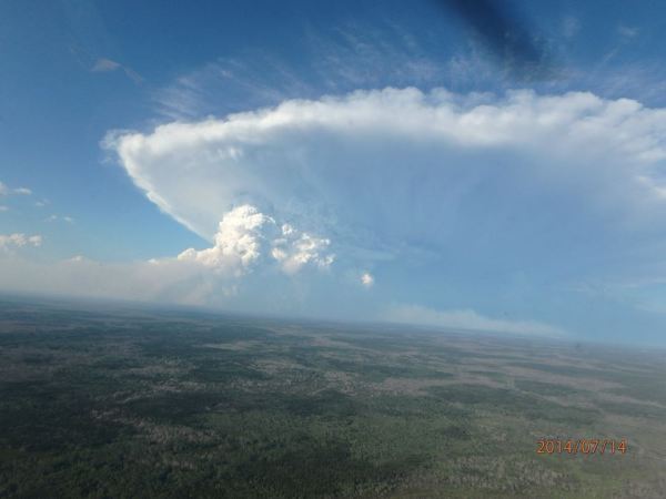
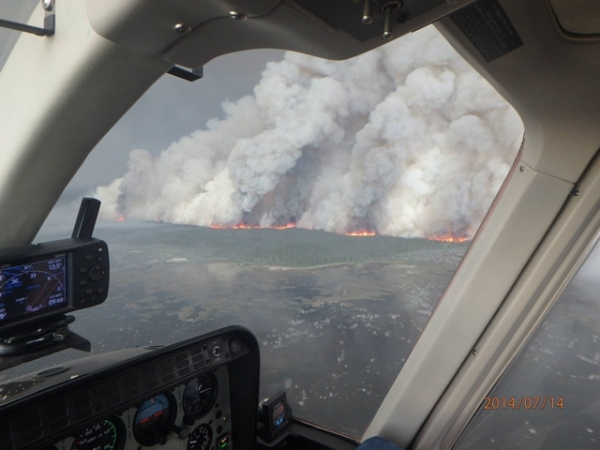
(Thunderstorm? No. Smoke from a major volcanic eruption injecting ash into the stratosphere? No. The upper frame shot is an aerial photo taken of the Birch Creek Fire Complex on July 14, 2014 from a distance of about 30 miles away. It is just one of the massive fires now raging in the Northwest Territory region of Canada. A closer picture, taken from a few miles out, reveals the flaming base of a massive smoke plume. Image source: NWT Fire Facebook.)

From helicopter and airplane, the volume of smoke pouring out of these massive tundra and boreal forest fires is amazing, appearing to mimic major thunderstorm complexes or volcanic eruptions. Closer shots reveal towering walls of flame casting billows of smoke thousands of feet into the air above.

The smoke from these fires, now numbering in excess of 186 separate blazes, is becoming entrained in the weakening circumpolar Jet Stream. The steely gray billows now trail in a massive cloud of heat-trapping black carbon that stretches more than 2000 miles south and east. Its southern-most reaches have left residents of the northwestern and north-central US smelling smoke for weeks, now. Meanwhile, the cloud’s eastern-most reaches approach Baffin Bay and the increasingly vulnerable ice sheets of Greenland.

Smoke from Canadian Wildfires drifts toward Greenland

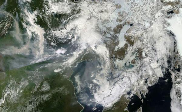
(Satellite shot of smoke from massive fire complexes over Canada spreading eastward. Black carbon and related CO2 emissions from forest fires can serve as a powerful amplifying feedback to already dangerous human-caused climate change. Image source: NASA/LANCE-MODIS.)

Across the Arctic, Siberia Also Burns

As media attention focuses on the admittedly horrific fires of unprecedented magnitude raging over Canada, a second region of less well covered but possibly even more extensive blazes burns on the other side of the Arctic Ocean throughout the boreal forest and tundra zones of Central Siberia in Russia.

There, record heat that settled in during winter time never left, remaining in place throughout summer and peaking in the range of 80-90 degree Arctic temperatures over the past couple of weeks. Over the last seven days, massive fires have erupted which, from the satellite vantage, appear about as energetic as the very intense blazes that ripped through Siberia during the record summer fire year of 2012. It is a set of extreme conditions we’ve been warning could break out ever since March and April when intense early season fires ripped through the Lake Baikal and Southern Yedoma regions.

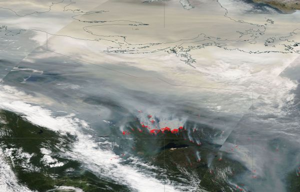
Now, what appears to be more than 200 fires are belching out very thick plumes of smoke stretching for more than 2000 miles over North-Central Siberia and on into the recently ice-free zone of the Laptev Sea:

Sea of Smoke and Fire From Lake Baikal to Arctic Ocean

(Massive sea of smoke and fire stretching from Lake Baikal and northeast over Central Siberia and on into the Arctic Ocean. Image source: NASA/LANCE-MODIS.)

As with the other set of fires in Canada, the smoke from these massive blazes is entraining in the Jet Stream and stretching across Arctic regions. An ominous blanket of steely gray for the roof of the world and yet one more potential amplifying heat feedback the Arctic certainly does not need.

Potential Amplifying Feedbacks in Context

During recent years, scientists have been concerned by what appears to be an increased waviness and northward retreat of the northern hemisphere Jet Stream. This retreat and proliferation of ridge and trough patterns is thought to be a result of a combined loss of snow and sea ice coverage over the past century and increasing over the past few decades. In 2012, sea ice coverage fell to as low as 55% below 1979 levels with volume dropping as low as 80% below previous values. Over the past seven years, not one day has seen sea ice at average levels for the late 20th Century in the north.

Meanwhile, northern polar temperatures have risen very rapidly under the rapidly rising human greenhouse gas heat forcing, increasing by 0.5 C per decade or about double the global average. It is this combination of conditions that set the stage for fixed ridges over both Russia and Canada creating extreme risk for extraordinary fires.

image

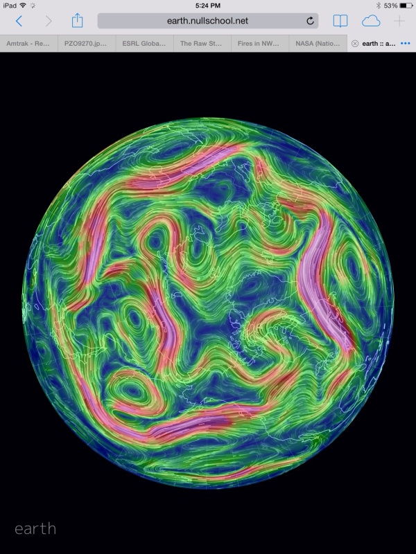
(Weak and wavy polar jet stream on July 17, 2014 shows fixed ridges over the Northwest Territory, Central and Eastern Siberia, Northern Europe and the adjacent North Atlantic and Arctic. Image source: Earth Nullschool. Data Source: NOAA GFS and various.)

Should both the current sets of fires continue to rage under anomalous high amplitude jet stream waves setting off extreme heat in these Arctic regions, it is possible that large clouds of heat absorbing black carbon could ring the Arctic in a kind of hot halo. The dark smoke particles in the atmosphere would trap more heat locally even as they rained down to cover both sea ice and ice sheets. With the Canadian fires, deposition and snow darkening are a likely result, especially along the western regions of the Greenland Ice Sheet — zones that have already seen a multiplication of melt ponds and increasing glacial destabilization over recent years.

Recent scientific studies have also highlighted the possibility that human-caused climate change is increasing high amplitude jet stream ridge patterns that are transporting more and more heat into Arctic tundra and boreal forest regions. These regions are more vulnerable to fires due to the fact that trees in boreal forest have uniform characteristics that favor burning and tend to rapidly ignite and spread once the upper branches become involved. The unfrozen soil features a narrow basement layer above tundra which dries more rapidly than the soils of more temperate areas, providing tinder fuel to aid in the initial ignition by lightning strike. Thawing, deeper tundra, when dried, is a meters-deep pile of fuel that has accumulated for thousands of years — a kind of peat-like layer that can smolder and re-ignite fires that burn over very long periods. It is this volatile and expanding basement zone that is cause for serious concern and greatly increases the potential fire hazard for thousands of miles of thawing tundra going forward.

Overall, both boreal forest and thawing tundra provide an extraordinary potential fuel for very large fire complexes as the Arctic continues to warm under the human greenhouse gas forcing. And though climate models are in general agreement that the frequency of fires in tundra regions will increase, doubling or more by the end of this century, it is uncertain how extensive and explosive such an increase would be given the high volume of fuel available. Direct and large-scale burning of these stores, which in tundra alone house about 1,500 gigatons of carbon, could provide a major climate and Earth System response to the already powerful human heat forcing.

Though the science at this point is uncertain, we observe very large and unprecedented fire outbreaks with increasing frequency:

“I think it’s really important for us to take advantage of studying these big disturbance events,” noted Dr. Jill Johnstone in a recent interview. “Because, if we can say anything, we can say that we think they’re going to be more common.”

UPDATE:

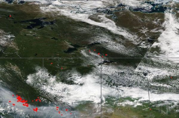
The smoke plume over North America has now expanded to cover a large section of the continental land mass. As you can see in the image below provided by NOAA, the smoke plume now stretches from the fire zones in the Northwest Territory (fires indicated by red dots), British Columbia, Washington, Oregon and California across much of the North American continent extending as far to the north and east as the southern tip of Greenland and as far to the south and east as Maryland, West Virgina and Tennessee:

Smoke Plume

(Massive North American Smoke Plume fed by Tundra and Western Forest Fires. Image source NOAA.)

As of today and yesterday (17 and 18 July) major wildfires continued to burn over much of the Northwest Territory of Canada even as these very large and unprecedented fire complexes were joined by massive outbreaks in British Columbia, Washington and Oregon. Fire outbreaks were so extreme in both Washington and Oregon that state officials there were forced to declare states of emergency and seek federal assistance for dealing with the ongoing disasters.

You can see the large, steely-gray smoke plumes from these fires in the LANCE MODIS image taken by NASA yesterday in the satellite shot below:

Massive fire complexes in Washington, Oregon and BC

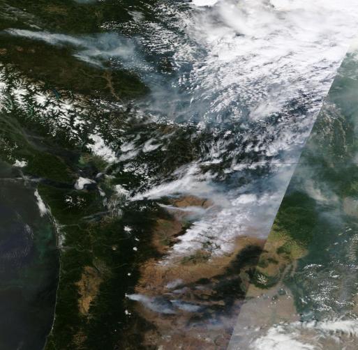
(Massive wildfires in Washington and Oregon prompt officials to issue disaster warnings. Image source: LANCE-MODIS.)

The smoke has become so pervasive that commenter James Cole has made some rather stark observations from Northern Minnesota:

A sky filled with grey haze, you can hardly tell there is a sun up there. No clouds in the sky, but the haze is incredible. Surely from the great Canadian fires!

Due to black carbon loading, such a large cloud of smoke may result in substantial temperature spikes over regions affected. The heat dome over the US West is expected to expand into the central and northern US this weekend with some readings there predicted to reach the 100s. Already, the southwestern heat is spreading north and eastward under the dome of heat-intensifying smoke with a broad area of upper 80s and lower 90s stretching all the way to the southern shores of Hudson Bay.

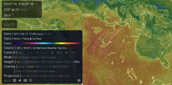
Meanwhile, on the other side of the Arctic, the expanse of wildfires continued to widen with the smoke plume now covering over 2,500 miles and with multiple very large blazes continuing over Central and Northeastern Siberia. Atmospheric black carbon and methane loading (more in a new post) likely contributed to temperatures in the range of 95 degrees F (35 C) near the shores of the Arctic Ocean’s Laptev Sea yesterday as recorded in the following screen capture from Earth Nullschool/GFS:

image

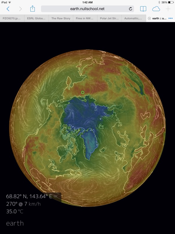
(35 C temperature [95 F]  recorded in northeastern Siberia near the Laptev Sea at about 12:30 AM EST on July 18. Image source: Earth Nullschool. Data Source: NOAA/GFS.)

Links:

Fires in Northwest Territories in Line with Unprecedented Burn

What Fires in the Northwest Territories Say About Climate Change

Recent Burning of Boreal Forest Exceeds Fire Regime Limits of Past 10,000 Years (PNAS)

NWT Fire Facebook

NASA/LANCE-MODIS

Earth Nullschool

NOAA GFS

Arctic’s Boreal Forests Burning at Unprecedented Rate

Large Particles From Wildfire Soot Found to Trap 90 Percent More Heat Than Small Particles

North American Smoke Plume Tracking by NOAA

Hat tip to Wili

Hat tip to James Cole


Late June 2014: Arctic in Hot Water as Sea Ice Thins and Tundra Fires Erupt

Atmospheric warming due to human-caused climate change. It’s the general measure we’ve used to track a devastating and ongoing heat amplification due to a terrible greenhouse gas emission. But if we were to look for where the greatest amount of that heat has accumulated, it would be in the world’s oceans. For from its air-contacting surface to its depths thousands of meters below, the World Ocean has captured 93.4% of the total heat forcing humans have already unleashed. The remainder is almost evenly divided between the atmosphere, the continents, and the ice.

We rely on floats and deep-plunging sensors to keep track of total ocean heat content. But on any given day we can see well enough what is happening at the surface. And today ocean surface heat is screaming through the world’s satellite sensors. Overall global anomalies are spiking higher than +1 C above the 1979 to 2000 average. In the Equatorial Pacific, an El Nino that looks to be far stronger than the one that occurred in 2009-2010 is building, heating a massive wedge of the Eastern Equatorial Pacific to +2 to +4 C above average. And in the far north, we see extraordinary high surface water temperature departures exactly where we need them least — bordering Greenland and the remaining Arctic sea ice.

Arctic Sea surface temperature Anomaly on Jun 24

(Arctic sea surface temperature anomaly on June 24, 2014. Image source: NOAA/NWS.)

For encircling the Arctic from the West Coast of Greenland, to Iceland, to Svalbard, to the Barents and Kara Seas, to the Chukchi and on to the Beaufort we see surface water temperatures ranging from 2.25 to 4 C or more above average. And just west of Svalbard, we have water temperatures ranging in a zone exceeding a terrifying 8 C above average. When a sea surface temperature departure of 0.5 to 1 C above average is considered significant, these values represent extremes that are far outside what was once considered normal.

Melt Pressure to Ice Sheets

Such high surface water temperatures have numerous effects. The first is that adjacent submerged ice sheets, such as the calving faces of Greenland’s great glaciers plunging into the ocean, are faced with a far greater melt pressure than before. The glacial fronts in many cases expose 500 or more feet of ice directly to these much warmer waters. And on almost every side of Greenland, but especially in the west, along Baffin Bay, these great ice masses are confronting extraordinary warmth. The heating is without respite. It occurs at all hours of the day and since it is delivered by water, it is many times more energy intensive than a similar volume of equally heated air.

Widespread Sea Ice Thinning and Melt

In the sea ice edge zone, the warmth also provides added heat pressure to the vulnerable and already greatly thinned ice floes. This heating is especially apparent in areas where continental rivers disgorge their waters into the Arctic Ocean. Warmer than normal water temperatures have coincided with much warmer than normal land temperatures, particularly over tundra regions like Canada’s Northwest Territory and the Yakutia region of Russia. These warmer lands result in warmer river flows. And the hot rivers spill into an already hotter than usual Arctic Ocean.

The result, as we can see in today’s MODIS satellite shots are numerous zones of greatly thinned ice.

Beaufort Thin Ice

(Ice melt, thin ice and melt ponds in the Beaufort Sea on June 25 of 2014. Image source: LANCE MODIS.)

A Beaufort Sea confronted with warm water outflow from the Mackenzie River, sea surface temperatures in the range of +1 to +4.5 C above average, and a broad swath of above freezing air temperatures, is now starting to show major melt effects. The sea ice has already withdrawn by as much as 150 miles from a broad section of the Canadian and Alaskan coasts. The off-shore ice features numerous very large polynyas and leads. And, overall, the ice has taken on a bluish tint indicative of widespread melt pond formation.

Russian Arctic Ocean sea ice june 25

(Arctic Sea Ice over the Laptev and East Siberian Seas. Image source: LANCE MODIS.)

Meanwhile on the far side of the Arctic, effects appear to be even more widespread. Though sea surface temperature values are somewhat lower than those seen in the Beaufort, at +0.5 to +1.25 in most open water areas, the entire region is rife with 150-200 mile wide polynyas, shattered and broken floes, and thinning (blue in the satellite picture) ice covered in melt ponds. The ice in this region is so frail that even the mildest storms, featuring 15-20 mph winds, are enough to rip through and splinter previously contiguous ice. And the storms in the region this year have been quite mild, ranging from 990 to 1000 mb in strength.

Sea ice measures show current area and extent at between 3rd and 5th lowest on record. That said, observed ice response to even the mildest high and low pressure weather systems reveals a startling vulnerability with much warmer than normal sea surface temperatures surely a contributing factor.

Wildfire Eruptions From The Northwest Territory to Siberia

In net, much warmer water temperatures and retreating sea ice in the Northern Hemisphere trigger both Jet Stream erosion and increasing south to north air flow. Over the continents, where lands are far more susceptible to rapid warming, this can result in Arctic regions seeing summer time temperatures comparable to those in latitudes much further south.

Over the past week, temperatures in the upper 70s to upper 80s (Fahrenheit) covered a broad region of Canada’s Northwest Territory including Alberta and the Mackenzie Delta region along the Beaufort Sea. These temperatures, in the range of 20-25 F above average rapidly dried out the shallow topsoil zone over the frozen and thawing tundra. Such rapidly dried soil and newly liberated tundra is a volatile fuel for fires. The human-thawed tundra itself contains burnable organic material and hosts pockets of methane while the dry soil bed is suffused with tinder-like grasses and shrubs. Any ignition can set off extraordinary fires of almost unimaginable scope and intensity.

Great Slave Lake Fires NWT

(Massive fires rage near Great Slave Lake in Canada on June 24, 2014. Image source: LANCE MODIS.)

By June 24, four massive fires, each with a front ranging from 20-30 miles in breadth, raged along the shores of Great Slave Lake in Northwest Canada. Four smaller, though still significant fires also burned nearby. The fires are plainly visible as white, comet-like plumes of smoke in the satellite picture above. For reference, Great Slave Lake is more than 200 miles across at its widest point. Bottom edge of frame is about 300 miles.

To the south and east by about 250 miles lies the Fort McMurray tar sands operation. A smaller, though still intense, tundra fire raged within 20 kilometers of that sprawling site but did not yet encroach on one of the most powerful and dangerous means of carbon-to-atmosphere delivery on the planet.

On the other side of the Arctic in Siberian, Russia, the situation was, once again, more dire. There a region very vulnerable to mid summer wildfires during recent years erupted into numerous blazes belching smoke into a swirling cloud caught up in the heat dome overhead:

Lake Baikal Fires Re-Ignite

(Massive region of wildfires North of Lake Baikal, Russia. Image source: LANCE MODIS.)

These fires were sparked by temperatures that, during recent days, ranged in the 80s and even 90s. An extraordinary heat forcing for rapidly melting tundra regions that also saw far warmer than typical temperatures this past winter.

This area, about 800 miles to the north of Lake Baikal, Russia, is a region of rapidly thawing tundra that has burned again and again during recent summers. For scope, the satellite shot frame, above, is 750 miles on an edge. In the picture are about 50 fires with fronts ranging from 4-35 miles.

This spring, a broad area to the south of the current fire zone and just north of Lake Baikal saw massive fire activity prompting Russia to dispatch an army of hundreds of firefighters to the region. Such intense fire activity so early was unprecedented for Russia. But the real fire season typically peaks from mid July to August. And, in the above picture, we see what is likely the opening salvo for the summer fire season in earnest.

Smoke and soot from these massive fires are swept up in the circumpolar Jet Stream. There they are born aloft for hundreds of miles, often traveling northward to find a final resting place upon the sea ice or atop Greenland’s glaciers. This ultimate darkening of the snow further enhances glacial melt even as it completes the cycle of warmth, finishing a dance of heat that rises up from the oceans, assaults the ice, and heats the once frozen lands to erupt in flame.


Links:

Support the Dark Snow Project

Where is Global Warming Going?

NOAA/NWS

LANCE MODIS

When April is the New July: Siberia’s Epic Wildfires Come Far Too Early

Global Warming Pushing Canadian Wildfires to Spike