(Image source: DMI)
Well, it’s official. PAC 2013 has yet to give up the ghost. After transitioning to the Canadian Archipelago, it has now formed a trough composing three low pressure centers that roughly straddles Greenland, Baffin Bay, and the thickest sea ice. At this point, the storm is nearly one month old (with a formation date around May 21-26). Lowest pressures appear to be around 990 mb, but the entire region is covered in rough weather and clouds.
A look at the heat map shows the storm pulling in warmer air from the Alaskan side of the Arctic and from regions around it. This extra energy has given it enough to fuel multiple lows for an extended period. As a by-product, many regions over the Central Arctic are now above freezing. Areas near the low pressure centers still show temperatures in the range of 0 to -3 Celsius. But a broad swath of above-freezing temperatures are now under the circulation of this, rather large, storm.
(Image source: DMI)
On the map, we also notice areas of high heat concentration centered over Scandinavia, Central Siberia, Alaska, and just West of Hudson Bay. These regions of heat are both potential launching pads for more warm air invasions of the Arctic as well as feeding sources for our storm, should it continue.
And, according to forecasts, we can find that this storm isn’t done by a long-shot. ECMWF model runs show it forming troughs with numerous low pressure cells and chewing through large portions of the Arctic all the way through to July 1. Seems we were right to caution against an end to PAC 2013 in this earlier blog.
A very interesting example is the ECMWF forecast for June 27th when PAC 2013 forms a sprawling trough from the East Siberian Sea to Baffin Bay to Greenland to the Kara. It is a trough composed of not one, not two, but at least six separate low pressure cells. The forecast for tomorrow through much of the model run shows similar configurations with daisy chains of storms linked by a trough swirling along through the Arctic.
(Image source: ECMWF)
These model runs would seem to indication very stormy conditions not only for the Central Arctic, but for the periphery as well.
The ‘Warm’ Arctic Storm Begins to Emerge?
With temperatures rising to above freezing in the Central Arctic Basin and with storms projected to persist at least until July 1rst, we may receive an unwelcome glimpse of the ‘Warm’ Storm described here. Previously, I had speculated that ‘Warm’ Storm conditions would be present with moderate-to-strong cyclones persisting in the Central Arctic at a time when air temperatures ranged from 0 to 6 degrees Celsius. As we can see from the temperature map at the top of the post, we are not far off from that threshold now. And with heatwaves popping up around the Arctic there is more than enough warmth to push Central Arctic temperatures higher over the coming days and weeks.
Over at the Arctic Ice Blog (read it, join it, follow it, chat on it — you will learn boatloads), expert posters Wayne and R. Gates have noted that while clouds block direct sunlight, they can act to trap long-wave radiation. R. Gates had also linked a recent scientific study which showed that cloudy conditions from March to May enhanced rather than inhibited melt. The energy of this long-wave radiation would transfer directly to ice and ocean, so atmospheric temperatures would not be directly impacted. But more heat content in the waters and ice, overall, might be providing some of the extra kick that ECMWF appears to have missed. Another recent study by Edward Hanna found that low level clouds helped to increase the record Greenland ice sheet melt of 2012 (study here) by trapping heat near the ice. So the overall effect of clouds in cooling is less certain than one would think at first blush.
Another source of this extra heat may be via the ocean itself. As noted in previous posts, cyclonic action creates a kind of pumping force (Ekman), that can pull water up from the ocean’s depths. In the Arctic, the surface layer is cold. But underneath lies a layer of warm water fueled by the inflow from oceans surrounding the Arctic (primarily the Atlantic). As commenter Johnm33 noted, once a strong inflow of upwelling water is established, it is possible that yet more warm water is being drawn into the deep Arctic Ocean from the Atlantic. If this warmer inflow was pumped to the surface, it would add to atmospheric heat beneath the storm.
Lastly, the atmosphere, via high amplitude waves in the Jet Stream is now also providing its own source of heat by dredging deep into the lower latitudes and pulling warmer air up into the Arctic. So far this summer, we have seen record heat waves in both Scandinavia and Alaska. These heat waves were caused by persistent blocking patterns that injected heat into these Arctic locations. Scandinavia saw temperatures in the 80s, Alaska saw temperatures rocketing into the upper 90s. The Jet Stream configuration allowing for these hot air injections at these locations still persists and are plainly visible on the current Jet Stream map:
(Image source: California Regional Weather Service)
Note the large wave in the Jet Stream (and associated warmer air) now riding up over Alaska and deep into the Beaufort, Chukchi, and East Siberian Seas. Another pulse is visible lunging up through Scandinavia. A third, though less southwardly linked, pulse is also now rising over Eastern Siberia. These extraordinarily high amplitude waves all cross far beyond the Arctic Circle. An atmospheric condition that is anything but normal and one that is also continuing to supply warmer air to the Arctic environment, even one covered by a storm that would normally substantially cool the atmosphere there (for more information on how snow and ice melt in the Arctic is enabling these high amplitude Jet Stream waves, take a look at some of the work of Dr Jennifer Francis). Instead, as the discrepancy with ECMWF predictions and surface observations shows, we have temperatures that are only .5 to 1 degree C cooler than average under the storm (they should be about 3-7 C cooler) and much, much warmer conditions surrounding it.
A Warm Storm persisting in the Central Arctic for long periods is a potential nightmare scenario for sea ice melt. Currently, we have warming conditions in the Central Arctic, a spate of record heat-waves at the periphery in places like Alaska and Scandinavia, a mangled Jet Stream that keeps pumping warmer air into the Arctic, and a storm that is now projected to persist until at least July 1rst. So we now have to consider at least the temporary emergence of the Warm Storm to be a possibility going forward.
Impacts to Sea Ice Still Ongoing, Likely to Ramp Up
A substantial thinning and chopping up of the sea ice is now apparent in all visible (when you can see through the clouds), concentration, and thickness monitors. Now, a wasteland of thinned, shattered and broken ice is visible in a swath from Svalbard all the way to Wrangle Island near the Bering Strait. A comprehensive graphic summary of these impacts is provided below:
(Image source: US Navy)
The current image, provided by the US Navy is a stark contrast to conditions seen at the end of May. This thickness measure shows a long ‘claw’ of much thinner ice reaching all the way in to the Central Arctic and encompassing the North Pole. This graphic reveals very poor Central Ice thickness conditions for mid-to-late June.
(Image source: US Navy)
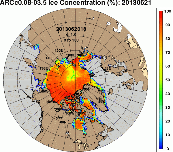
The US Navy surface concentration graphic also reveals very broken conditions for the Central Arctic in mid-to-late June.
(Image source: Uni Bremen)
Uni-Bremen has been providing consistent confirmation of ice damage and fragmentation due to the Ongoing Arctic Storm for nearly two weeks now. Here’s the most recent concentration monitor showing the broad swath of broken ice.
(Image source: Cryosphere Today)
And Cryosphere Today, which is less sensitive than the other monitors shows low ice concentrations stretching from Svalbard to Wrangle Island.
Overall, should PAC 2013 continue to warm even as it persists, it should have ever-greater deleterious effects on the Central Arctic sea ice as mid-to-late June transitions into July. The US Navy thickness forecast shows ongoing thinning and fracturing in this region all the way through June 28th. One interesting feature of note in this forecast is that it appears a substantial section of ice will be separated from the main pack and stranded in the Kara Sea if current trends continue through early July.
(Image source: US Navy)
The Storm That Just Won’t Quit
So, apparently against all odds, PAC 2013 continues and, even worse, shows risk of beginning a transition to a ‘Warm’ Storm in the Central Arctic. Should this trend remain in effect, increasingly visible damage to the central ice is likely to become ever more apparent as June turns to July.
Links:
California Regional Weather Service
Jennifer Francis Explains How Sea Ice and Snow Melt impact the Jet Stream


Sourabh
/ June 21, 2013I think we should add an extra adjective to its name. “Stuck” PAC (:P) . Just like Jet stream, Arctic weather seems to be stuck in this warm stormy conditions.
LikeLike
robertscribbler
/ June 21, 2013Yep. Every time it leaves it gets yanked right back into the Central Arctic.
Stuck… Seems we’re stuck with it for the next ten days if those weather models hold true.
LikeLike
robertscribbler
/ June 21, 2013… I’m starting to get large tundra fires on Lance-Modis too.
Shaping up to be another ‘interesting’ summer…
LikeLike
Sourabh
/ June 21, 2013Tundra fires? Where? Is it due to methane leakage or wildfires ?
LikeLike
robertscribbler
/ June 21, 2013Wildfires in central Siberia. Writing about it now. No way to directly link these to methane seeps in the region. That said, the increased levels of methane there do make things a bit more volatile.
LikeLike
Sourabh
/ June 21, 2013I thought you might be interested in this.
http://ajw.asahi.com/article/behind_news/social_affairs/AJ201306210059
LikeLike
robertscribbler
/ June 22, 2013Thanks for this. So the Japanese are projecting 3.25? A pretty low end point. I’m a bit lower. Thinking 2.5 and a 2.8 average for September. But that could be over-done. We’ll see.
You have a projection?
LikeLike
Sourabh
/ June 22, 2013I do. Its more like guesstimate. My projection for area is less than 2. For extent, its more like 2.5 to 2.8km2, same as yours.
My projections are lower because i) volume has been declining more rapidly than extent/area ii) this year’s arctic ice is thick at the edges and thin at the center. Edges melts anyway. Also, due to cracks in March and recent cracks due to PAC, central ice is vulnerable more than ever. I think this year is much more unique in multiple aspects such as distribution of ice thickness/vulnerability/cracks at center etc.. I don’t think any storm in past has caused so much damage to central ice as PAC did.
We have entered into total uncharted territory of arctic ice. Any natural variations are going to be much more amplified. “Any thing that can go wrong will go wrong”–Murphy’s laws….
LikeLike
Sourabh
/ June 22, 2013Here is another interesting video.
LikeLike
robertscribbler
/ June 23, 2013Oof. That’s a real sucker punch. Will definitely need to blog about it.
LikeLike