It’s an El Nino year. So that’s supposed to mean a quiet Atlantic Hurricane Season, right? But as the tenth storm of 2015 threatens intensification, very heavy rains, and broadening wind fields as it’s expected to cloak itself in a frontal storm along a track a little south of Sandy — it appears a climate change — riled ocean and atmospheric system have failed to get the message.
Anyone looking at today’s ocean-atmospheric conditions and the Global Forecast System model run predictions probably couldn’t shake off the shivers as a number of chilling similarities to Superstorm Sandy began to show up in the five day outlook. The forecast is very, very uncertain. But it appears we might have a developing Superstorm-like Joaquin on our hands.
“There is going to be catastrophic flooding from North Carolina to Massachusetts, and this is going to disrupt the economy regardless of whether or not Hurricane Joaquin makes landfall.”
All Eyes on Joaquin As Climate Change Pattern Dominates North Atlantic
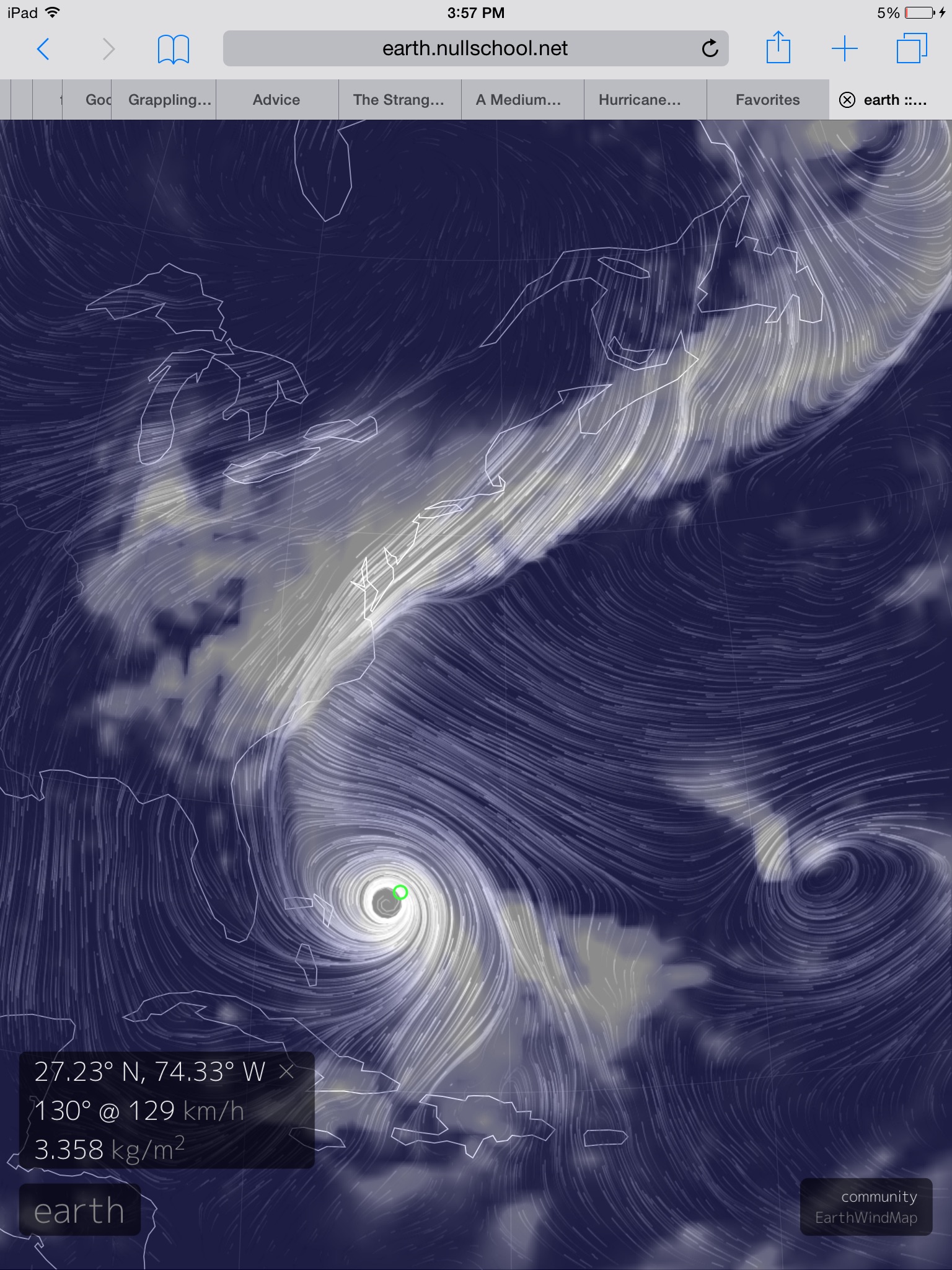
(GFS water vapor and wind forecast for October 2 shows a category 2-3 Jaoquine interacting with a powerful trough stretching down across the US East Coast. A trough extending all the way from Norway. Though not a polar trough like the one that interacted with Sandy, and though Joaquin’s characteristics aren’t as likely to go extra-tropical like Sandy, the broadening wind field, the potential left turn and the superstorm combining of trough and hurricane are potentially similar features. Image source: Earth Nullschool.)
A freakish ‘Storms of My Grandchildren‘ type cool pool dominates the northern Atlantic. The backed-up Gulf Stream off the US East Coast is super hot (1-6 degrees Celsius above average). A massive trough is digging in — telegraphing from Norway through Iceland on to Southern Greenland, extending yet southwest over Newfoundland and the Northeastern and Mid Atlantic US. Further south, a developing Hurricane Joaquin over the Bahamas is about to shake hands with this massive trough. Just south of Newfoundland, a blocking high pressure system appears ready to bar Joaquin’s passage to the north and east. Setting up the potential for Joaquin to embed in the trough, to develop a rapidly expanding wind field even as it strengthens, and to possibly make a sickening left turn into the US East Coast.
Jaoquin Forecast — Very Stormy Five Days for US East Coast
Currently, Jaoquine is a strengthening category category 2 hurricane packing 105 mile per hour (updated) winds as it drifts toward the southwest near the eastern Bahamas. Over the next two days Jaoquin is expected to strengthen, possibly into a powerful major hurricane, even as it begins to track toward the north and west. This track will result in its interacting with the large trough mentioned above. Even if Jaoquine does not make landfall, its interaction with the trough is expected to dump substantial and torrential amounts of rainfall from North Carolina on through New England even as it drives a broad tropical storm force wind field and related storm surge onto shore.
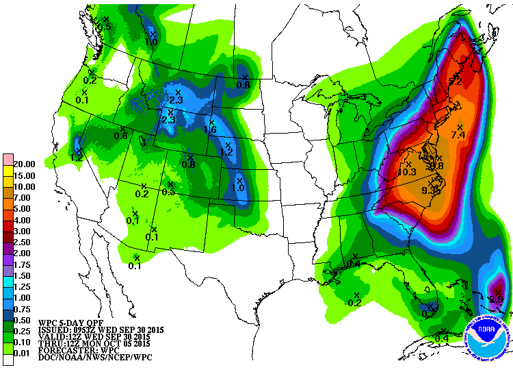
(NOAA five day rainfall forecast shows potential for significant related flooding for the Eastern Seaboard. Image source NOAA CPC.)
According to NOAA forecasts, 5 day rainfall totals are now expected to exceed 7 inches throughout large sections of North Carolina, Virginia, Delaware, New Jersey and Maryland with measures in excess of 5 inches expected from South Carolina all the way to Nantucket.
Joaquin’s wind field is also expected to expand as it interacts with both the trough and large circulation of the blocking high to the north and east. This broad wind field will bring at least strong nor-easter like conditions to the US East Coast. But the broad clockwise circulation off the blocking high also heightens risks that Joaquine will be shoved onshore even as it strengthens.
Current model runs bring a powerful category 1-3 Joaquine, packing a broad wind field with maximum strength from 90-115 mph, on shore near the North Carolina/Virginia border at around 2 PM Eastern Time on Sunday, October 4:
(The National Hurricane Center shows Joaquin following a course the brings it over the Outer Banks and up the Chesapeake Bay. A worst case track for many sections of the US East Coast. Image source: NHC.)
If such a forecast does play out, it’s bad news. Very very bad news. It would represent a potentially very severe category 1-3 storm embedded in a large wind field and an even larger rain shield. A storm bringing heavy rains for days and lashing the coast with gale force winds up to 24 hours in advance of landfall. Features that would greatly enhance storm surge and flooding impacts — which could be very far reaching. It’s a dangerous potential interaction between Joaquine, a persistently extensive trough stretching across the North Atlantic, and one of the new, heavyweight, blocking patterns that have become so prevalent in this age of human-forced warming. One that could again wrap a hurricane in a, this time very wet, nor’easter.
Like Sandy, it would also serve as a herald for the oncoming new, more intense climate-change driven storms of our present age. Storms that have greater north-south energy exchanges. Storms that may be more more likely to form embedded or hybridized systems and storms that tap both the higher potential pressure and temperature differentials as well as an atmosphere that is more heavily laden with moisture.
(Escaping the Valley Fire. Central Valley resident flees unprecedented and dangerous climate change spurred fires late Sunday night. Human forced warming is making these fires more common — creating a very dangerous situation for the US West.)
Now, as of early morning on Tuesday, nearly 150,000 acres of wildfires in Central California have destroyed more than 700 homes and over 1,200 structures, endangered more than 9,000 more, resulted in the calling up of an army of 2,000 firefighters (For this region alone. Across the US West more than 18,000 firefighters are battling blazes), killed at least one person, and forced more than 23,000 to flee (see more here). It’s an egregious human toll. One in which more and more people are saying heart-wrenching words like these — “We have nothing.”
(Climate change refugees in the USA. Thousands of California residents have been displaced and hundreds have lost their homes due to a recent severe wildfire outbreak related to human-caused climate change. Video source: State of Emergency Declared.)
Perhaps the worst thing of all about these globally mounting tragedies is the fact that these increasing instances of extreme, climate change driven weather, were preventable. Now we are forced to live with the damage, danger, and tragic loss of lives and homes we’ve already locked in. Now we are forced to hope that wiser leaders than the ones we’ve had thus far will work as hard as possible to limit the degree of terrible harm that is all too certainly on the way.
“We are really in a battle with nature, … nature is more powerful than we are.”
Partly true. What’s really happening is that we’ve riled nature into a climate change driven frenzy of heat and fire. And it’s becoming too violent for us to manage.
The world is now well on its way to seeing back-to-back hottest years on record. Unprecedented and amoral burning of fossil fuels is now forcing the global temperature average to rise into the range of 1 degree Celsius above 1880s averages — or halfway to a catastrophic 2 C warming. A level at which scientists believe many climate change tipping points will be irrevocably crossed.
June, July, August Were Hottest On Record
According to NASA GISS, global temperatures for the June, July and August period of 2015 were 0.78 degrees Celsius (C) above the 20th Century benchmark or about 0.98 C above 1880s averages — when global record keeping began. The previous hottest three month period occurred during 1998 at +0.72 C. Notably, June, July and August were the hottest three months for 1998. But for 2015, December, January and February came in at +0.83 C and March, April and May came in at +0.81 C. These extreme temperature departures, when combined with the June, July and August readings, now put 2015 at +0.80 C above average for its first 9 months — or well above any previous record-breaking year. A significant single year margin above the previous hottest year — 2014 — of +0.05 C (a single year rate of warming about 150 times the average rate of warming at the end of the last ice age).
(NASA GISS spatial anomalies map for August of 2015. Image Source: NASA)
August of 2015 Comes in As Second Hottest Amidst Global Warming And El Nino Signature Temperature Anomalies
August itself came in at +0.81 C above NASA’s 20th Century benchmark average. This departure marked the second hottest August reading in the 135 year temperature record, falling just 0.01 C behind the previous hottest August reading hit just last year (2014).
Geographic distribution of temperature anomalies continue to show the signatures of both a strong El Nino and a growing climate change related signal. The August El Nino signature was particularly strong in the Eastern and Central Equatorial Pacific with 1-4 degree Celsius hotter than normal temperature departures dominating the region. This heat extended throughout the anomalous ‘Hot Blob’ or ‘Ridiculously Resilient Ridge’ zone that has continued to be dominated by extreme sea surface temperature departures with 1-4 degree Celsius above normal temperatures pervading. Such extreme heat was linked to equally extreme drought and wildfire conditions dominating broad sections of the North American west throughout the month. Conditions that, for many areas, have been endemic for many months running.
Anomalous heat also dominated the land masses of South America, Europe, South Africa, and the Lake Baikal region of Russia. These areas experienced some or all of the following: extreme drought, wildfires, water resource stresses, extreme heat-related weather, and heatwaves. A cool pool in the Northern Atlantic between England and Newfoundland remained a prominent feature. This cool region is associated with climate change related conditions that are now in the process of weakening both the Gulf Stream and North Atlantic bottom water formation. It’s a set of conditions that weakens equator to mid-latitude heat transport and intensifies the North Atlantic storm track. An upshot of human-forced warming that has been predicted for decades by even the most rudimentary of global climate models but that now appears to be cropping up a bit earlier than previously expected (see World Ocean Heartbeat Fading?). Persistent troughs over Eastern North America and Western Russia also generated their own cool pools. Meanwhile, surface temperatures over Central Antarctica dipped into cooler values — likely associated with intensification of storm systems in the Southern Ocean.
(NASA zonal temperature anomalies show a signature consisted with strong El Nino and related equatorial warming. Image source: NASA GISS.)
NASA’s zonal anomalies map also displayed a strong El Nino signature with the global equatorial zone showing the highest above average temperature departures (in the range of +1.3 degrees Celsius). This extreme heat maintained throughout the Northern Hemisphere mid-latitudes all the way to 60 North before falling off to between +0.2 to +0.4 C near the pole. Progressing southward, anomalies steadily declined, even dipping into a range of 0 to -0.9 C anomalies in the region of 75 to 90 South.
Conditions in Context — Record High Temperatures and Related Extreme Weather in the Pipe
Consistent high temperature departures near the Equator, as we see now, tend to aid both in storm track intensification and a general flattening of the Jet Stream. Though these conditions have not yet dominated in the Northeastern Pacific, a continuation of the August temperature departure pattern and related strong El Nino will likely both intensify the Northeastern Pacific and North Atlantic storm tracks as Fall progresses. Such a shift, however, would have to be very extreme to bust the 3 year running California Drought.
Overall temperature departures for both August and for the June, July, August period are well outside the range of anything that could be considered normal and are swiftly rising to more and more unsafe and climate destabilizing levels. The emergence of the North Atlantic cool pool is a feature specifically related to storm intensification and regional and global weather destabilization. A feature predicted by global climate models due to human forced warming, related melting of Greenland ice, and the upshot slowing down of critical ocean currents. The recent unprecedented Hot Blob in the Northeastern Pacific was likewise predicted in the scientific research as a result of human forced warming — a feature that, it was warned, could result in much warmer and drier conditions for the North American West Coast. Climate change related heat signatures such as these clearly show in the NASA monitor even as the global measure keeps rising to new and more dangerous extremes.
(Please support public, non special interest based, science like the fantastic work done by NASA’s GISS division and without which this report and related analysis would not have been possible.)
Large plumes of methane bubbling up from the Arctic Ocean sea-bed, saturating the water column, venting into the air, adding significantly more heat forcing to an already dangerous, fossil fuel-based, accumulation of greenhouse gasses in the Earth’s atmosphere. It’s a nightmare scenario. One in which human-forced warming, already at 1 C above 1880s levels, is further amplified through the feedback release of ancient carbon stored over the past 8 million years of Northern Hemisphere glaciation. And a recent study by the now famous Semiletov and Shakhova team provides still more reason for appropriate concern that such an event may be in the works.
(Shakhova and Semiletov’s new study produces an increasingly clear picture of a destabilizing organic carbon store beneath thawing permafrost in the East Siberian Arctic Shelf region. The above images show organic carbon concentration [left frame] and rate of release of methane in grams per square meter per day over observed regions. Image source: The Royal Society.)
At issue is the fact that, at the end of the last ice age, a great store of permafrost carbon was submerged as the Arctic Ocean rose. A low lying region containing about 500 billion tons of carbon as methane became inundated by the shallow sea that is the East Siberian Arctic Shelf (ESAS). The waters of this sea remained cold — below the freezing point of non-salt water in its lower reaches for most of the year. But, in some places, warmth invaded, and it is thought that small portions of the permafrost cap deteriorated.
In the near shore zones and in geologically active zones, methane conduits called taliks developed. And from these expanding taliks an increasing amount of methane bubbled to the surface.
(Ivashkina Lagoon was once a thermokarst lake. It has since been flooded by the Laptev Sea. For much of the time of inundation, the fresh water lake surface remained frozen. It is now thawing and releasing its organic carbon store as methane. Image source: The Royal Society.)
However, for the most part, the permafrost cap over the methane stores remained in tact — waiting to be rejuvenated by a new ice age. That is, until human industry belched billions of tons of carbon into the atmosphere, removing the possibility of a new ice age and forcing the world ocean and connecting Arctic Ocean to begin to warm in excess of peak Holocene temperatures. This warming, twice as fast in the Arctic as in the rest of the world, added still more heat pressure to the permafrost cap locking methane within the ESAS sea floor.
Now, more and more permafrost beneath the shallow ESAS waters is starting to thaw. And this, much more rapid than normal thaw is resulting in an increasing risk that methane stores beneath the permafrost cap will destabilize.
Shallow Waters, Geothermal Hot Spots, Taliks
Recent observational records by Dr. Natalia Shakhova and Dr. Igor Semiletov have found what they hypothesize to be an expanding array of methane vents in the East Siberian Arctic Shelf sea bed. According to their recent research, the vents appear to be growing more robust — bubbling up greater volumes of methane from a more vigorous and inter-connected network of channel beneath the thawing sea floor.
(Ever since 2005, atmospheric methane levels have again been on the rise. Much of this increase may be due to human emissions. However, an overburden of atmospheric methane and carbon dioxide in the Arctic zone hints that destabilizing carbon stores may also be adding substantial volumes of greenhouse gasses to the world’s airs. Image source: NOAA OSPO.)
Currently, according to Shakhova and Semiletov, methane emissions are most vigorous in the near-shore region of the ESAS and in the offshore slope region. Shakhova and Semiletov believe that near shore emissions are increasingly active due to rapid warming occurring there. Not only are the regional waters impacted by a rapidly warming Siberian land mass. They also see the flux of hotter waters from rivers issuing from the continent. As a result, the near shore region is most vulnerable to permafrost thaw and destabilization. In the slope zone, however, geological features are more active. These features provide a natural heat for the formation of taliks. And though most of this region was once frozen to the point that even geological activity did not result in methane venting, the now warming permafrost cap is generating weaker regions that natural geological heat can exploit to greater and greater degrees.
The increased rate of methane release is not only due to permafrost thaw on the sea floor. It is also due to an increase in large polynyas in the ESAS during winter time as well as an overall increase in the area of open water that can be impacted by storms. An ice locked ESAS keeps more of its methane in the water column and gives the methane a longer period to be absorbed by the water or consumed by microbes. But as the ice recedes, more of the methane is able to break the surface and reach the airs above. In addition, ice free seas are more susceptible to the action of storms. Storms increase wave heights, increase the rate of breaking waves, and reduces ocean surface stratification. As a result methane moves more rapidly through the upper level water column and encounters a larger surface area from which to transfer from water to air.
An ice free ESAS is not only warmer, generating more destabilization forcing to the permafrost cap which locks in methane, it is also more and more devoid of the surface ice cap which acts as a secondary barrier to methane to air transfer.
Shakhova, Semiletov Recommend Adding ESAS Methane Release to Global Climate Models
Shakhova and Semiletov’s findings continue to compel them to issue warnings over the prospect of continuing increases in methane emissions from the ESAS and nearby seas. They conclude:
The observed range in CH4 emissions associated with different degrees of subsea permafrost disintegration implies substantial and potent emission enhancement in the ESAS as the process of subsea permafrost thawing progresses with time. While it is still unclear how quickly CH4 flux rates will change, the current process of Arctic warming and associated sea ice loss will accelerate this process. The potential for the release of substantial amounts of CH4 from the ESAS region has important implications not only for atmospheric CH4 concentrations but also, given CH4‘s potency as a greenhouse gas, for the global climate. Because the ESAS contains the largest and arguably most vulnerable stores of subsea CH4, inclusion of the ESAS source in global climate models should be considered a high priority.
Two climate change spawned monsters are duking it out over thousands of miles of Pacific Ocean waters. And in a human heated world its an epic battle between these two warming fueled atmospheric and oceanic goliaths — the Godzilla El Nino versus the Pacific Ocean’s Hot Blob.
* * * * *
Ridiculously Resilient Ridge. RRR. Blocking high pressure system. All names given to a sprawling heat dome that has plagued the U.S. West Coast for the better part of two years running. It’s a weather system largely responsible for the California drought — the worst in at least 1200 years. A weather system implicated in an extraordinarily intense outbreak of wildfires across the North American West from Alaska through British Columbia and all along the US West Coast — including within the usually moist rain forests of Washington and Oregon.
(The RRR is shrinking and increasingly besieged by storms. A sign that the El Nino related Pacific Storm track intensification is beginning to assert. Image source: Earth Nullschool.)
It’s a system connected to a climate change-enforced melting of Arctic sea ice and a similarly forced warming of the Northeastern Pacific Sea surface far above typical temperatures (see here,here, and here). An unprecedented and extreme heating of waters into a ‘Hot Blob’ stretching for thousands of miles. A related drying of airs. Oceanic and atmospheric heat energy generating an implacable atmospheric bully. A high pressure system so powerful it typically flung Pacific Ocean storms far off course — as far north as the High Arctic.
But now the RRR is starting to weaken. Its great northward extending ridge has retreated from Alaska. Intense storms exploding out from a system that is likely to rival the strongest El Nino on record (1997-1998) are now surrounding the ridge, nibbling away at its edges, cooling the waters of the hot blob through Ekman pumping, and raging on through Alaska and the Pacific Northwest.
(Storm-based upwelling is starting to cool Northeastern Pacific Ocean waters in a region that has been dominated by the Hot Blob during recent years. A condition that is undermining some of the RRR’s support. El Nino based storm generation to the south will likely continue to aim blows at this oceanic heat base. Image source: Earth Nullschool.)
It’s early sign of RRR collapse. That the Hot Blob is starting to fail. With some of the precursors to likely far more intense Fall and Winter storms starting to get caught up into its spiraling decline. And as sea surface temperature anomalies are likely to hit 2.0 to 2.3 C above average in the Niño 3.4 zone in this week’s NOAA El Niño report, more RRR-challenging storms are likely on the way.
As Ricky Rood over at Weather Underground said this week it’s Godzilla vs the Blob. And Godzilla, at this point, appears to have the upper hand. And once the Blob goes down there’s nothing to keep what are likely to be some seriously epic storms slamming into the west coast of North America this Fall and Winter. But according to recent science, there’s a high risk that the Blob will creep on back as the Godzilla El Nino retreats during mid to late 2016. And for the West Coast that means high risk of a pretty vicious cycle of drought to flood to drought. A dangerous weather pattern intrinsically related to human-forced climate change.
Over the past two weeks, news of the plight of a swelling wave of refugees fleeing to Europe has filled the mainstream media. We looked on in horror at reports of innocent human beings fleeing destabilized countries in the Middle East, of people suffocating while stuffed into the backs of trucks, of drowned children washed up on the shores of nations their families had hoped would care for them.
It’s all a part of a growing global mass migration. A tragic dislocation and diaspora. But this time it’s not only birds, or polar bears, or fish, or walruses, or insects, or plants that are being forced to move by habitat and food loss, by toxified environments or by increasingly dangerous weather. It’s human beings too.
* * * * *
“Everything I was Dreaming of is Gone”
(Dead Syrian toddler is not only a victim of conflict. He is a victim of a destabilized climate. Video source: Here)
In the above video we are rightfully compelled to compassion for a drowned boy and his family. A family suffering in a country ripped apart by conflict. A country fractured by insurgent forces that will use any form of brutality to gain and secure power. And in this very narrow frame we are provided with a perpetrator — ISIS — and an-all-too innocent victim. The call for warfare against the human monsters that make up ISIS is clear. But the conditions that created the monster in the first place, as happens all too often with climate change, are completely ignored.
Climate Change as Threat Multiplier in Syria
Syria was never a stable country. At least not so long as colonial and post colonial powers inhibited its development as a functional state. There was always a reason for interference in Syria’s affairs and for a related exploitation of its resources. As the fossil fuel age dawned, such interference became even more intense. Powerful nations and empires wanted Syria’s oil. And when Syria’s oil was gone and the country left suffering from the bitter after-effects of that resource’s deleterious curse, those same powers wanted Syria to remain both stable and weak. To remain sidelined so as not to influence the flow of oil from nearby countries. Countries like Iraq where the West has conducted an ongoing war since the early 1990s.
We justified this under such international relations terms as the realism-based ‘rational self interest of nations.’ And it was this self interest paradigm that national and international businesses — primarily oil companies — used to justify an ongoing exploitation of an increasingly fractured land, its people, and of a resource itself whose continued burning would make an ugly situation far, far worse.
“Rising global temperatures, changing precipitation patterns, climbing sea levels and more extreme weather events will intensify the challenges of global instability, hunger, poverty, and conflict. They will likely lead to food and water shortages, pandemic disease, disputes over refugees and resources, and destruction by natural disasters in regions across the globe.”
What he failed to mention, however, was that for Syria and ISIS it had already happened.
The Drought that Forged ISIS
Before there was ISIS, there was drought. A three year long drought beginning in 2007 and finally ending in 2010. A drought so severe and intense that it basically wiped out Syria’s farming industry. The farmers, mostly family farmers, were faced with a situation in which water use was terribly constrained (due to the combined drought severity and the short-sighted policies of the Syrian government). Farm after farm failed. By 2011, more than 1.5 million people had migrated from the ruined and desiccated rural farms to the cities. Cities that, in turn, became hot-beds of unrest and insurgency.
(Map published by NOAA in its 2011 report on Mediterranean drought during 2005 to 2010. In a related finding, Syria experienced its worst drought on record during 2007 to 2010 resulting in the mass loss of farmland and the displacement of 1.5 million people to urban centers. Image source: NOAA — Climate Change Probably A Factor in Syria’s Civil War.)
A scientific report published in the Proceedings of the National Academy of Sciences in March found that Syria’s epic 2007-2010 drought had been developing over the course of a century of warming. That the drought was both spurred and made more severe by human forced climate change. And that the increased intensity of drought added by human forced warming likely pushed Syria’s rural farms past the breaking point. The report noted:
There is evidence that the 2007−2010 drought contributed to the conflict in Syria. It was the worst drought in the instrumental record, causing widespread crop failure and a mass migration of farming families to urban centers. Century-long observed trends in precipitation, temperature, and sea-level pressure, supported by climate model results, strongly suggest that anthropogenic forcing has increased the probability of severe and persistent droughts in this region, and made the occurrence of a 3-year drought as severe as that of 2007−2010 2 to 3 times more likely than by natural variability alone. We conclude that human influences on the climate system are implicated in the current Syrian conflict.
The drought, therefore, led to desperation, hunger, anger, and unrest. It provided a mass of displaced persons who had lost the means to provide for themselves and their families. It provided both the trigger and the means for the development of what would later become ISIS (for more on how the Syrian drought helped destabilize the country you can read this brief, but very informative, comic strip). Threat multiplier indeed.
Worst Heatwave in 130 Years Forces Russian Crop Failures, Spurs Arab Spring
As is well known, the flood of refugees coming to European shores are not solely Syrian. Libya, Egypt and a broad number of African and Middle Eastern countries now face destabilizing unrest, violence, and growing numbers of internally displaced persons seeking asylum in other countries. It is this now endemic instability and displacement that can be primarily linked back to two events — drought-spurred crop failures in 2010 and the related food riots that ignited what is now known as the Arab Spring.
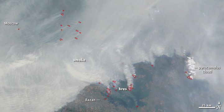
(Wildfires and pyrocumulous clouds over Russia during the great heatwave of 2010. A heatwave that killed 50,000 people and crippled Russia’s agricultural industry. Image source: Earth Observatory and Discovery News.)
By 2011, global food prices — spurred ever-higher by wide-ranging droughts and extreme weather — put millions of people in the Middle East and North Africa in a desperate situation. Food became less and less accessible. In Egypt, the plight of a child set off mass food riots. These food riots spread across the Middle East resulting in the collapse of Egyptian, Syrian, and Libyan governments. Setting in place the severe refugee situation we see today.
Climate Change as Trigger to Europe’s Refugee Crisis
In emerging threats terminology, given the scientific basis for climate change’s influence on extreme weather events related to the refugee crisis, related to the destabilization and collapse of nations, we can identify the Syrian and Russian droughts and heatwaves as precursor crisis influencing and trigger events. What the US Department of Defense terms threat multipliers. Climate change, in this instance, made the Syrian drought and the Russian heatwave worse. These impacts in turn increased desperation, displacement, and hunger in numerous countries spurring unrest and, in some cases, societal collapse.
In Syria, 1.5 million people were directly displaced as the result of a climate change worsened drought. In the Middle East as a whole, nations were indirectly destabilized due to a crop-destroying and climate change worsened heatwave in Russia which set off a wide-ranging food crisis. This destabilization, in its turn, led to still more internally displaced persons in places like Libya and Egypt. Many of whom eventually joined the rising flood of human traffic to the still greener shores of Europe.
And it is in this way that climate change is a root cause to Europe’s refugee crisis. For without climate change we remove the extreme weather amplifier which is a trigger to the whole growing disaster.
(Kivalina, Alaska is one of 31 communities now being devoured by the Arctic Ocean and Bering Sea due to a combination of sea level rise, permafrost thaw, and increased wave action due to loss of sea ice. Image source: The Union of Concerned Scientists.)
In total, around the world, 158 million people were displaced by extreme weather events related to climate change since 2008. The fires, floods, hurricanes, extreme droughts, heatwaves and other storms are all growing worse, more violent, more likely to destroy homes and livelihoods. And it’s due to the heat we’ve added into the Earth’s climate system that extreme weather is now a greater direct cause of displacement than even the terrible scourge of warfare.
Some of the persons driven from their homes by such worsening events are able to eventually return to their livelihoods. But some are bereft of necessary aid — living in regions or nations which lack the resources to help. Such persons eventually become tent dwellers or add to the ever-growing tide of people seeking refuge in other, more seemingly stable, countries.
Climate change, extreme weather, human displacement and related political instability are thus now linked in a broad web that spans the globe. And the situation keeps getting worse and worse. It’s a situation that won’t change anytime soon. And one that can only be abated by a concerted response by nations — all of which are now under threat — to both help those people put in this terrible situation and to stop worsening the damage through a rapid cessation of fossil fuel based carbon emissions. Otherwise, by failing to rapidly act, by focusing instead on broadening warfare and conflict rather than root causes, more and more nations and regions will fall under the threat of destabilization, mass impoverishment and collapse as this climate change spurred crisis grows in scope, breadth and intensity.
According to reports in the Associated Press, on September 1 of 2015, Kiev shattered its all-time record high temperature as readings rocketed to 35.5 C (96 F) in a city stifling under the pall of bog-fire smoke. The city ordered school cancellations and urged restraint in the use of fossil fuel burning vehicles as gray smog choked the city pushing air pollution levels to between 2 and 18 times normal.
For Kiev, it was just one more hot, dry day among many. A heat dome high pressure system has dominated the region for much of late July through early September. And rainfall totals for the past month were just 4 percent of average. Now bogs across a wide swath of Ukraine and Russia are drying out, issuing tell-tale plumes of smoke, and filling the region with a choking smog.
(Drought and heat induced bog fires blanket Ukraine and Western Russia in a dense cloud of smoke on September 3 of 2015. Image source: LANCE MODIS.)
The impact of the lack of rain and high temperatures could be felt across many sectors. Agricultural production was reduced, and forests dried out and became more susceptible to insect attacks. Hydropower production decreased, rivers fell to record low levels, and inland water transport was completely shut down in some places.
By today, temperatures across Ukraine and extreme Southwestern Russia had risen to an amazing 12-14 degrees Celsius above average (21 to 25 degrees Fahrenheit hotter than normal for this time of year). It’s a ridiculous extreme temperature departure for a mid-latitude region. The scorching center of a stifling dome of hot air that extends from the Caspian Sea all the way to Poland and Italy.
(Temperatures in Russia and the Ukraine today hit 12-14 C above the already hotter than normal 1979-2000 baseline in the GFS model summary by Climate Reanalyzer.)
This record heat, drought and fire danger is expected to linger over the impacted regions for at least until Sunday. Then, a trough digging in through Eastern Ukraine is expected to shove the hot pool eastward into Russia and Kazakhstan. Setting the stage for record hot conditions running along a ridge extending from the Middle East through Russia and Siberia and on into the Arctic.
Increased rates of Greenland melt, increased fresh water outflow from rivers into the Arctic Ocean, and increases in ice berg calving have provided more fresh water to the Arctic Ocean (which would tend to cool the ocean surface) and weakened the south-to-north heat transfer of the Gulf Stream. Under such conditions, we’d tend to expect more than a little rebound in Arctic sea ice coverage. What we instead saw was a brief bump in the sea ice area, extent and volume measures during 2013 and 2014.
(Japan’s sea ice monitoring facility finds Arctic extent values at second lowest on record for September 2, 2015. Image source: JAXA.)
It’s a trend well below the 2014 pseudo-recovery year. One that is now tracking just beyond the previously record-smashing 2007 trend line. The measure of 4.346 million square kilometers is about 60,000 square kilometers below 2007. And though still quite a bit higher than 2012, it’s a swing that pushes toward a somewhat unsettling reassertion of the long-term melt trend. A trend that since the 1970s has reduced late season sea ice coverage by nearly half.
Other measures, though slightly less pronounced than the JAXA monitor, also show significant departures below the pseudo-recovery years 2014 and 2013. The NSIDC extent measure places the 2015 melt season as roughly tied with 2007 as second lowest on record and a 4.586 million square kilometer coverage. Meanwhile, sea ice area is tracking the 2010 melt line at 6th lowest on record for the date at 3.322 million square kilometers — a substantial 370,000 (approximate) square kilometers below 2014 — in the Cryosphere Today measure.
Conditions in Context — Preparation for Another Record-Breaker in 2016 and 2017?
Given recent science and observations showing increased rates of Greenland melt, increased fresh water flows into the Arctic Ocean, and a slowdown of the Gulf Stream, North Atlantic Overturning Circulation, and a related development of a cool pool between Greenland and England, we should probably assume that the Arctic is now involved in a climate change feedback tug of war. On the one hand you have rising atmospheric greenhouse gas levels in the Arctic due to a combination of human emissions and a growing carbon feedback response from permafrost and seabed stores. This heat-trapping atmospheric witch’s brew couples with loss of sea and land ice albedo to push for a continued rapid Arctic warming. On the other hand, you have fresh water outflows interrupting some of the south-to-north heat transfer in the North Atlantic and keeping a lid on some of the ocean heat in the High Arctic and near Greenland.
(A storm churns through the Laptev Sea on September 3, 2015, hurling 25-35 mph winds and 6-10 foot seas at the nearby ice. Trends show that 2015 is likely to be a year of ice losses, with end summer area and extent values in the range 2nd to 6th lowest on record. Image source: LANCE MODIS.)
Adding to this volatile mix is a potentially record-shattering El Nino which will, over the course of the next two years generate an ocean and atmospheric heat pulse that will probably maximize in the Arctic come 2017. Since 2015 is seeing returns to sea ice area and extent values in the range of 2010, 2011, 2008 and previous record low year 2007, there appears to be a preparation for the Arctic to challenge 2012 record low values over the 2016-2017 time period. And if sea ice does hit new record low values during that period of heightened risk we can also expect the whip-lash melt response from Greenland to grow even stronger.
Trichodesmium. It’s the bacteria that’s solely responsible for the fixation of nearly 50 percent of nitrogen in the world’s oceans. A very important role for this microscopic critter. For without nitrogen fixation — or the process by which environmental nitrogen is converted to forms usable by organisms — most of life on Earth would not exist.
Now, a new study produced by USC and the Massachusetts-based Woods Hole Oceanographic Institution (WHOI), has found that human carbon emissions are set to drive this essential organism haywire. Forcing evolutionary changes in which the bacteria is unable to regulate its growth. Thus generating population explosions and die-offs that will be very disruptive to the fragile web of life in the world’s oceans.
(A Trichodesmium bloom off New Caledonia. Image source: Earth Observatory.)
Trichodesmium — A Mostly Helpful Bacteria Essential to Ocean Life
Trichodesmium is a form of cyanobacteria. It resides in the near surface zone composing the top 200 meters of the water column. Possessing gas vacuoles, the bacteria is able to float and sink through the water column in order to access the nutrients it needs for growth — nitrogen, iron, and phosphorus. A widespread bacteria, it is often found in warm (20 to 34 C), nutrient-poor waters in the Red Sea, the Indian Ocean, the North and South Atlantic, the Caribbean, near Australia, and in the Northeastern Pacific.
Trichodesmium congregates in blooms which are generally a straw-like color. For centuries, this coloration has generated its common name — sea straw. However, in higher concentrations it can turn waters red. The Red Sea, for example, owes its name to this prolific little bacteria. Trichodesmium blooms generate a strata that support mutualistic communities of sea creatures including bacteria, diatoms, dinoflagellates, protozoa, and copepods. These small organisms, in turn, are fed on by a variety of fish — notably herring and sardines.
But Trichodesmium’s chief role in supporting ocean health is through making nitrogen in the air and water available to living organisms. It does this by turning environmental nitrogen into ammonia as part of its cellular metabolism. This ammonia can then be used for growth by a wide variety of creatures on up the food chain. Trichodesmium is an amazing producer of this biologically available nitrogen — perhaps generating as much as 50 percent of organic nitrogen in the world’s oceans (70 to 80 million metric tons) each year.
Human Fossil Fuel Burning is Projected to Drive Trichodesmium Haywire
But now a new study by USC and WHOI shows that atmospheric CO2 concentrations projected to be reached by the end of the 21st Century in the range of 750 ppm CO2 could force Trichodesmium’s nitrogen fixation rate into overdrive and lock it there indefinitely.
(Rate of nitrogen fixation in Trichodesmium at 380 ppm CO2 [black and red], at 750 ppm CO2 [pink, yellow and light blue], and when CO2 levels are returned to 380 ppm after five years of exposure to 750 ppm levels [dark blue]. Image source: Nature.)
The study subjected Trichodesmium to atmospheric CO2 concentrations (750 ppm) projected under a somewhat moderate rate of continued fossil fuel burning scenario by 2100 for five years. After this five year period of exposure, Trichodesmium nitrogen fixation rates nearly doubled (see above graphic). But, even worse, after the Trichodesmium bacteria were returned to the more normal ocean and atmospheric conditions under 380 ppm CO2, the rate of nitrogen fixation remained elevated.
In essence, researchers found that Trichodesmium evolved to fix nitrogen more rapidly under higher ocean acidity and atmospheric CO2 states at 750 ppm levels. But when atmospheric levels returned to 380 ppm and when oceans became less acidic, Trichodesmium’s rate of nitrogen fixation remained locked in high gear. For an organism like Trichodesmium to get stuck in a broken rate of higher metabolism and growth is practically unheard of in evolutionary biology. Organisms typically evolve as a response to environmental stresses. Once those triggers are removed, organisms will typically revert to a near match of previous states. Strangely, this was not the case with Trichodesmium.
“Losing the ability to regulate your growth rate is not a healthy thing. The last thing you want is to be stuck with these high growth rates when there aren’t enough nutrients to go around. It’s a losing strategy in the struggle to survive.”
Uncontrolled Blooms, Population Crashes, Biotoxin Production, Dead Zones
Nitrogen is a key component of cellar growth. So Trichodesmium nearly doubling its rate of nitrogen fixation means that the bacteria’s rate of production will greatly increase as atmospheric CO2 levels and ocean acidification continue to rise. Under heightened CO2, the bacteria essentially loses its ability to restrain its population.
(Large algae/bacterial blooms like this red tide off La Jolla, San Diego are causing the expansion of hypoxic and anoxic dead zones throughout the world’s oceans. A new study has found that one of the ocean’s key microbes goes into growth overdrive as atmospheric and ocean CO2 concentrations rise — which would greatly enhance an already dangerous rate of dead zone expansion in the world ocean system. Image source: Commons.)
As a result, researchers warn that Trichodesmium blooms may run out of control under heightening levels of CO2. Such out of control blooms would rapidly remove scarcer nutrients like phosphorous and iron from the water column. Once these resources are exhausted, Trichodesmium would begin to die off en-masse. As with other large scale bacterial die-offs in the ocean, the decaying dead cellular bodies of Trichodesmium would then rob the nearby waters of oxygen — greatly enhancing an already much amplified rate of anoxic dead zone formation. And we know that anoxic waters can rapidly become home to other, far more dangerous, forms of bacterial life. In addition, large concentrations of Trichodesmium are known to produce biotoxins deadly to copepods, fish, and oysters. Humans are also rarely impacted suffering from an often fatal toxicity response called clupeotoxism when the Trichodesmium produced toxins biomagnify in fish that humans eat. Sadly, more large Trichodesium blooms will enhance opportunities for clupeotoxism to appear in human beings.
Exacerbating this problem of heightened Trichodesmium blooms and potential related dead zone formation is the fact that ocean waters are expected to become more stratified as human-forced warming continues. As a result, more of the nutrients that Trichodesmium relies upon will be forced into a thinner layer near the surface — thus heightening the process of bloom, die-off, and dead zone formation.
Final impacts to ocean health come in the form of either widely available nitrogen, (during Trichodesmium bloom periods) which would tend to enhance the proliferation of other microbial life, or regions of nitrogen desertification (during Trichodesmium die-offs). It’s a kind of ocean nitrogen whip-lash that can be very harmful to the health of life in the seas. One that could easily ripple over to land life as well.
No Return to Normal
But perhaps the most shocking finding of the new research was that alterations in Trichodesmium’s rate of growth and nitrogen fixation may well be permanent after the stress of high CO2 and ocean acidification are removed. Hinting that impacts to ocean health from a rapid CO2 spike would be long-lasting and irreparable over anything but very long time-scales. Yet more evidence that the best thing to do is to avoid a major CO2 spike altogether by cutting human carbon emissions to zero as swiftly as possible.
The Hot Blob in the Northeastern Pacific held its own for quite some time. But it now faces the assault of a barrage of tropical cyclones spat from the maw of a monster El Nino that is now tracking its way toward the strongest such event on record. If this keeps up, the Ridiculously Resilient Ridge warding storms off the US West Coast will be besieged by increasingly powerful cyclonic systems. The Ekman pumping from such storms will cool the ocean surface at its periphery and expanding toward its heart, eventually crushing the ocean impetus for ridge formation. The continuation of such a pattern could then kick Bjerknes feedback into higher gear — opening wide the door for powerful storms striking the US West Coast this Fall and Winter.
(Signs that powerful Fall and Winter storms are coming for the US West Coast? From north to south, strong cyclones are starting to put the squeeze on the Ridiculously Resilient Ridge. The Central and Eastern Pacific between 10 and 30 North, in particular, shows an eye-widening number of tropical cyclones. As of Tuesday, September 1, a whopping four tropical systems were churning northward out of an extremely hot El Nino zone. Image source: Earth Nullschool.)
By today, the furthest northward cyclones had vented their fury and dropped in intensity. Meanwhile, a fourth storm — tropical depression 14-E — was in the process of exploding over the very hot waters of the Eastern Pacific. It’s an unprecedented number of storms flowing out of what may become the strongest El Nino on record as part of a powerful ocean-atmospheric feedback.
Strong Bjerknes Feedback to Crush RRR?
Now, this strong storm pulse is starting to put the squeeze on the famed Ridiculously Resilient Ridge (RRR). It’s a persistent ridge that for the better part of three years has turned storms away from the US West Coast — deepening already prevalent drought conditions over California and threatening water security across the US West.
But now the RRR is surrounded by storms. A strong frontal trough runs from 30 North across the Central Pacific and on up into the Bering Sea. Another significant late summer low churns off the Pacific Northwest — running south and east toward Seattle and British Columbia. And four tropical cyclones push northward into the ridge’s southern boundary. It’s a full court atmospheric press. One that, through the mechanism of Ekman pumping, will push for the generation of upwelling and related cooling of the Northeastern Pacific waters beneath the RRR.
(Sea surface temperature and atmospheric conditions are beginning to fall more in line with an El Nino related pattern called Bjerknes Feedback. Image source: NOAA.)
If this happens, a good portion of the RRR’s atmospheric inertia will fail — opening wide the door for a powerful west to east storm track development fed by heat rising off a Monster El Nino sprawling over the Equatorial zones. It’s a pattern that’s starting to look like a rather significant Bjerknes-type feedback to a record or near record El Nino. One that may well continue to develop and grow ever-stormier as Fall progresses.
2015 El Nino Still Heating Up, Expected to Heat Up More
Feeding the powerful pulse of storms is a still-heating Equatorial Pacific. As of Monday, NOAA’s Weekly El Nino Report found that the critical Nino 3.4 zone had warmed 2.2 degrees Celsius above average. This warming follows an inexorable three month rise that began in June and has mostly continued unabated. Furthermore, seasonal trends together with the already powerful observed atmospheric feedbacks would tend to continue to push surface warming through October and November. So it’s likely that an El Nino that has already ventured well into monster event range will warm further over the coming 4-10 weeks — setting the stage for a possible excession of 1997’s record setting intensity.
Conditions in Context: Look Out For Rough Weather Coming to US West Coast
Though it’s too early to lock in the death of the RRR, conditions are lining up that will continue to put the squeeze on this persistent weather pattern. As a result, chances for some very intense storms beginning to slam into the US West Coast starting during October, November and December are on the rise. For those looking to a possible end to the droughts, wildfires and water shortages in the Western US, this potential change in conditions may be seen as a relief.
However, such an extreme switch brings with it the distinct possibility that storms associated with a potential strongest El Nino on record will be very disruptive. The droughts and numerous wildfires throughout the West have established soil conditions that will only enhance flood related impacts. Powerful rains associated with El Nino will likely increase erosion and further damage soils in regions already impacted by the severe droughts, mass tree deaths, and wildfires related to human forced climate change and fossil fuel burning.
(As of August 13, 2015, some parts of California were facing a rainfall deficit of 2 years or more. In order to break the drought, 2015’s monster El Nino would have to set off severe flood conditions during Fall and Winter. With the RRR under threat, is California staring down the barrel of a switch to an equally ridiculous barrage of storms? Image source: National Weather Service, Phoenix.)
To this final point, parts of California are now entering a 2 year rainfall deficit. A deficit that, in some places, equals 30-40 inches or more. A monster El Nino crushing the RRR and massively amplifying the Pacific Ocean storm track and pumping immense volumes of moisture into the mid-latitudes raises the risk that this much water or more could be dumped upon parts of California and the US West Coast in little more than a season. A switch from persistent, crushing drought to flash flood that could be extraordinarily disruptive.
(Please support public, non-special interest based science like the fantastic El Nino reports provided by NOAA and without which this analysis would not be possible.)


