Monsoon Disrupted By El Nino + Climate Change as India Suffers Deaths, Crop Losses from Extreme Heat.

May is the month when the massive rainstorm that is the Asian Monsoon begins to gather and advance. This year, as in many other years, the monsoon gradually formed along the coast of Myanmar early in the month. It sprang forward with gusto reaching the Bay of Bengal by last week.

And there it has stalled ever since.

On May 25-27, an outburst of moisture from this stalled monsoonal flow splashed over the coasts of India. But by the 29th and 30th, these coastal storms and even the ones gathering over the Bengali waters had all been snuffed out. The most prominent feature in the MODIS shot of India today isn’t the rainfall that should be now arriving along the southeast coast, but the thick and steely-gray pallor of coal-ash smog trapped under a persistent and oppressive dome of intense heat.

Monsoon Disrupted

(MODIS shot of India on May 30th. See the open stretch of blue water in the lower right frame? That’s the Bay of Bengal which borders coastal India. During a normal year at this time, that entire ocean zone should be filled with the storm clouds of a building monsoon that is already encroaching on coastal India. Today, there is nothing but a smattering of small and dispersed cloud through a mostly clear sky. Image source: LANCE-MODIS.)

Monsoon Described as Feeble

Official forecasts had already announced as of May 27th that the annual monsoon was likely to be delayed by at least a week for southeast regions of India. Meanwhile, expected monsoonal rainfall for western and northern sections of India for 2014 fell increasingly into doubt.

From The Times of India:

The monsoon is likely to be delayed by 10 days, according to scientists at the Indian Institute of Tropical Meteorology (IITM) here. The IITM’s third experimental real-time forecast says that a feeble monsoon will reach central India after June 20 as against the usual June 15. Last year, the monsoon had covered the entire country by June 15.

The annual monsoon is key to India’s agriculture. The substantial rains nurture crops even as they tamp down a powerful heating that typically builds throughout the sub-continent into early summer. Without these rains, both heat and drought tend to run rampant, bringing down crop yields and resulting in severe human losses due to excessive heat.

But, this year, heat and drought are already at extreme levels.

Major Heatwave Already Results in Loss of Life for 2014

As early as late March, the heatwave began to build over the Indian subcontinent. The heat surged throughout the state, setting off fires, resulting in a growing list of heat casualties, shutting down the power grid and spurring unrest. Meanwhile, impacts to India’s agriculture were already growing as the Lychee fruit crop was reported to have suffered a 40% loss.

By late May, temperatures across a broad region had surged above 105 degrees shattering records as the oppressive and deadly heat continued to tighten its grip.

In a country surrounded on three sides by oceans, it is a combination of heat, humidity and persistently high night-time temperatures that can be a killer. Wet bulb temperatures surge into a high-risk range for human mortality during the day even as night-time provides little respite for already stressed human bodies. Such extreme and long-duration heat doesn’t come without a sad toll. As of today, early reports indicated a loss of more than 56 lives due to heat stroke (In 2012 and 2013, total Indian heat deaths were near 1,000 each year). That said, final figures on heat losses are still pending awaiting complete reports from all of India’s provinces.

“Climatologically, we know that heatwaves are increasing in frequency and the number of days exceeding 45ºC temperatures is increasing. The frequency will increase further with global warming, hence this is a good example of a situation where science and disaster management can come together and avert damage,” a spokesman for India’s National Disaster Management Authority noted on Friday.

Hot Dust

(Hot Dust. A dust storm rolls through New Delhi on Friday amidst furnace-like 113 degree heat snarling traffic and resulting in the tragic loss of 9 more lives. Image source: Gaurav Karoliwal/YouTube Screenshot.)

Today the heatwave continued to gain ground, with Kota and Rajasthan reaching an all-time record of 116 degree F (46.5 C) as New Delhi’s mercury hit 113 degrees F in the midst of a drought-induced dust storm. Dust shrouding the city spurred traffic chaos and in the heat, darkness, and confusion nine more souls were lost.

After two months of growing disruption due to heat and drought, the lands and peoples of India cry out for a Monsoon that is running later and later with each new weather report.

Climate Change + El Nino: Adding Heat and Beating Back the Monsoon

As systems approach tipping points, they are more likely to tilt toward the extremes.

For India this year, its seasonally warmest period from April to May found severe heat amplification from a number of global factors. First, climate change seeded the ground for the current Indian heatwave by adding general heat and evaporation to already hot conditions. With global average heating of +0.8 C above 1880s levels amplifying in the hot zones, early moisture loss due to higher-than-normal temperatures produces a kind of snowball effect for still more warming. Essentially, the cooling effect of water evaporation is baked out early allowing for heat to hit harder just as typical seasonal maximums are reached.

Equatorial Pacific Ocean Temperatures May 30

(Equatorial Pacific Ocean temperatures warmed to +0.63 C positive anomaly on May 30th, extending further into El Nino Range. Image source: University of Maine.)

In addition, this year saw rapid progress toward an El Nino event in the Pacific Ocean with sea surface temperatures warming into the El Nino range by mid-May and continuing to ramp higher. By today, Equatorial Pacific anomalies had hit +0.63 C according to GFS analysis, extending a run into El Nino conditions.

El Nino events typically allow for the formation of hot, drier air over India. These air masses tend to engender extreme heatwaves like the one we are seeing now even as they delay the onset of cooling monsoonal rains. In essence, the monsoon is confronted with a heavy and entrenched wall of hot air that doggedly resists being shoved aside. And this is the very situation we observe now over India — a sputtering monsoon to the east getting bullied by a brutally hot and thick air mass that just won’t give ground. Climate change only exaggerates the problem by increasing the intensity and inertia of the hot air mass.

Major monsoonal disruptions typically occur during years following an El Nino’s peak heating impact. For example, in 1998, during a period following an extreme El Nino, India suffered one of its most severe droughts and monsoonal delays on record. But during recent years preceding El Nino, such as 2009, India also saw severe heat, drying, and crop damage due to a weakening of the annual summer rains. So an early monsoonal enfeeblement and coincident strong heatwaves and droughts over India with El Nino still forming is cause for some concern and bears further monitoring.

Currently, temperatures over India are surging to between 5 and 12 degrees Celsius above already hot averages. With heat and drought firmly in place, forecasts are calling for a 1 to 2 week delay in the cooling and moisture-bringing monsoon as India continues to swelter.

Links:

Heatwave Persists Across India

LANCE-MODIS

Northern India to Endure Scorching Heat and Drought due to Weak Monsoon

Heatwave Continues in Raj, Kota

Lychee Crop Suffers 40% Loss Due to Heatwave

Dust Storm Blamed for 9 Deaths, Transportation Nightmare

Indian Monsoon Delayed as Heatwave Continues

Ten Day Delay in Monsoon

El Nino Delays Rain, May Spell Trouble for Government

El Nino May Disrupt Monsoon

(Hat Tip to Colorado Bob RE Tipping Points)

(Hat Tip to Mark from New England for Excellent Clarifying Questions)


Nature: Human-Destabilized Antarctica Capable of Glacial Outbursts Contributing to Sea Level Rise of 14+ Feet Per Century

“Our new results suggest that the Antarctic Ice Sheet is more unstable than previously considered…” — Peter Clark, Paleoclimatologist at Oregon State University

*    *    *    *    *

Massive glacial destabilization and irreversible collapse caused by human warming. That’s what a flurry of recent studies issued by NASA’s Jet Propulsion Laboratory found is now happening to vast sections of Antarctica’s towering glaciers.

The NASA climate scientists found that rapid human warming of the deep ocean was resulting in hotter than usual water upwelling beneath the ocean-fronting glaciers of Antarctica. The warmer waters ate away at the great glaciers from underneath, making them less stable and propelling them with ever-higher velocity toward the world’s oceans. The studies, led by Eric Rignot, concluded that large sections of Antarctica were now destabilized and that six key glaciers representing what could well be termed the entire flank of West Antarctica were now locked in an unstoppable plunge into the ocean.

These glaciers in irreversible collapse combined with a growing number of destabilized and destabilizing glaciers all around Antarctica and northward to Greenland to represent an extreme risk for a much more rapid than expected sea level rise this century.

Now a new study published this week in the prestigious science journal Nature adds to what has become an extraordinary torrent of evidence for heightening risks to speeding human-spurred sea level rise.

Antarctica glacial velocity map

(Antarctica glacial velocity map composed by Eric Rignot in 2011. Blue = fast. Brown = slow. Note the numerous high-speed glacial flows plunging deep into Antarctica. By the 2010s, Antarctica was losing between 1,300 and 2,000 gigatons of ice each year. Image credit: Antarcticaglaciers.org.)

A Glimpse into Earth’s Past Provides Stark Evidence For a Human-Warmed Future

The study, entitled Millennial-Scale Variability in Antarctic Ice Sheet Discharge During the Last Deglaciation, and published in Nature, took a closer look at Antarctic ice sheet instability and its contribution to sea level rise during the end of the last ice age by taking sediment cores from iceberg rafted debris (IBRD) fields around the frozen continent. These fields contained minerals left by melting glaciers discharged into the Southern Ocean during the major glacial melt events at the end of the last ice age and provide a good proxy for the rate of glacial discharge from Antarctica.

Analysis of these sediment cores resulted in the finding that Antarctica experienced 8 separate large glacial outburst events during the end of the last ice age. These events began about 20,000 years ago and ended 9,000 years ago. This is directly counter to conventional thinking that had assumed Antarctic melt started late and ended early during the last glacial melt period. It also hints that the Antarctic ice sheet is far less stable that previously assumed, making it much more vulnerable to current, human-caused heat forcings.

Each large outburst event contributed significantly to global sea level rise. The largest and most violent event was found to have occurred around 14,900 years ago. Lasting 350 years, this single episode, known as meltwater pulse 1A, resulted in a 50 foot sea level rise, pushing global oceans higher by 14.2 feet per century. It was previously unknown that Antarctica contributed in any way to this rapid sea rise event. But large deposits of iceberg sediment during this time of surging oceans provides strong evidence that Antarctica was a major contributor.

Post-Glacial_Sea_Level

(Pace of post glacial sea level rise since the end of the last ice age. Note the steep rise in sea levels occurring in conjunction with meltwater pulse 1A, a pulse that scientists now know included a major contribution from Antarctic melt. Image source: Commons.)

Professor Clark of Oregon State’s College of Earth, Ocean and Atmospheric Sciences who contributed to the paper noted:

“During that time, the sea level on a global basis rose about 50 feet in just 350 years – or about 20 times faster than sea level rise over the last century. We don’t yet know what triggered these eight episodes or pulses, but it appears that once the melting of the ice sheet began it was amplified by physical processes.”

Implications for Current-Day Human Warming

At first blush, the findings of this study may seem innocuous. But upon reflection, one quickly comes to the conclusion that they are rather stark.

In total, about 200 feet of potential sea level rise is currently locked in all of Antarctica’s ice. This compares to Greenland which, if it completely melted, would contribute about 24 feet to sea level rise. Until recently, it was assumed that this large store of ice in Antarctica was relatively stable and responded only slowly to climate perturbations.

The first challenge to the notion of Antarctic ice sheet stability came in 1968 when glaciologists began issuing warnings that the West Antarctic Ice Sheet was unstable. But, until recent years, this instability lacked an observed physical mechanism to explain what appeared to be an ongoing and increasingly rapid glacial rush toward the sea. By the mid 2000s, scientific reports began to emerge showing that warm water upwelling along the coasts of Antarctica was eating away larger and larger chunks of the great glaciers’ bases and speeding their flow to the sea. This year, a flurry of reports sounded a death knell for entire sections of West Antarctic ice, locking in many feet of sea level rise with more likely to come.

Temperature increase over last 22,000 years

(Temperature and CO2 increase from 22,000 YBP through 6,000 YBP. Note that major glacial outburst events in Antarctica began after only .2 C of atmospheric warming and 10 ppm of CO2 increase around 20,000 years ago. Such a response shows a very high degree of glacial and Earth Systems climate sensitivity. Also note that total warming over a 12,000 year timeframe was 3.7 C. Warming of 4, 6 and even 9 C is possible by the end of this Century under BAU human greenhouse gas forcing. Image source: Nature via Skeptical Science.)

But until this recent Nature paper, such a rapid destabilization of Antarctica’s massive glaciers was without a paleoclimate context. For few studies had challenged an assumed but sparsely supported perception of past Antarctic ice sheet stability. To the contrary, the paper found an Antarctic ice sheet that was very sensitive to warming. The ice sheet issued its first major glacial outburst 20,000 years ago as the world showed its first hint of thaw from a great ice age. The giant glaciers continued their lashing out in 8 major events until warming stopped with the advent of the Holocene around 9,000 years ago. At that point, Earth’s climate had begun to settle into a new equilibrium and Antarctica quieted its grumbling.

Now that humans are warming the atmosphere and oceans at a pace at least 30 times that of the last ice age, we are discovering that Antarctica in the deep past showed a major destabilization response to even the slightest hint of warming.

A Warming Ocean is Likely Antarctica’s Soft Underbelly

Rapidly accumulating evidence that ocean warming is providing a powerful blow to the world’s glaciers combines with the recent study to provide a stark implication — any addition to atmospheric heat is rapidly transferred to the world’s oceans which, in turn, goes to work melting ocean-contacting glaciers. Furthermore, glacial destabilization is likely to remain in play so long as the global energy imbalance toward continued warming remains in force and destabilized glaciers haven’t yet hit the ocean. As such, we should consider that start time for glacial destabilization and increasing rates of sea level rise to be now and not in some distant, far off, future.

Glacial systems may well present considerable atmospheric inertia. But when presented with warming waters, the glaciers must yield. This makes sense as water’s heat capacity is four times greater than that of air. So the melting force of water just one degree C above freezing is about four times that of the same volume of air at the same temperature. Glaciers in constant contact with the potent heat capacity of warming oceans essentially don’t stand a chance. And with many of Antarctica’s glaciers directly in the firing line of waters warmed by human greenhouse gas forcing rising from the deep ocean, it would appear, at this time, that the great frozen continent may well have a very soft underbelly.

Antarctic Waterfall

(Waterfall spilling from the heart of a melting Antarctic glacier and into the Southern Ocean. Image source: Antarctica.gov.au)

Inertia Not So Strong as the Forcing; Stark Implications For Sea Level Rise

Since so much has happened over the past year, it is useful to put the current state of science into an overall context. In doing so we should consider these scientific findings:

  1. Large portions of Antarctica are already undergoing destabilization or irreversible collapse.
  2. In the deep past, Antarctica responded very rapidly to even a small global temperature change and remained unstable so long as warming continued.
  3. This rapid glacial response and destabilization was likely due to a broad basal exposure to warming oceans.
  4. The current pace of human warming is now 30 times faster than at the end of the last ice age.
  5. The deep ocean is accumulating heat faster than any other Earth System.
  6. At peak, the most violent glacial outburst flood events included glacial discharges from Antarctica and pushed sea levels higher by 14.2 feet each century during the end of the last ice age.
  7. Current human CO2 heat forcing at 400 ppm + is enough to raise sea levels by 75 feet according to paleoclimate estimates.
  8. Current human CO2e heat forcing at 481 ppm + is enough to raise sea levels by 120 feet according to paleoclimate estimates.

Considered together, these points would seem to indicate that glacial inertia to heat forcing is not so great as previously hoped. More likely, the energy balance of the Earth System more rapidly responds to total heat content, energy imbalance, and pace of heat accumulation than previous sensitivity estimates assumed. If this meta-analysis is true, and it seems to be based on a growing pile of evidence, sea level rise for the current century is likely to be far greater than previously anticipated by scientific assessments. The top range of a 3 foot sea level rise for this century under IPCC modeling is likely, given current realities, to instead be a low estimate. A more realistic range, given a greatly reduced true glacial inertia, is probably 3-9 feet through 2100 with higher outside potentials during large glacial outburst flood events.

Given changing ocean and atmospheric conditions together with the rising potential of large rainfalls over certain glacial zones during summer as the 21rst century progresses, climate analysts should consider such large glacial outburst floods to be a potential high risk event under current extreme human warming. It is also worth noting that these glacial systems have probably never experienced a set of forces so powerful or rapid as they are likely to face as the 21rst century progresses. Recent scientific assessments are essentially playing catch-up to these new and emerging realities.

Links:

Grim News From NASA: West Antarctic’s Entire Flank is Collapsing into the Southern Ocean

Millennial-Scale Variability in Antarctic Ice Sheet Discharge During the Last Deglaciation

Commons

Nature

Skeptical Science

Antarctica.gov.au

Antarctic Ice Sheet Unstable at End of Last Ice Age

Antarcticaglaciers.org

Storms of My Grandchildren Rising: Hurricane Amanda Sets Record as Strongest Eastern Pacific Ocean Cyclone in May

Category 5. Only the most powerful of the most powerful storms on Earth reach this ominous peak. It’s a designation that occurs when hurricanes achieve a highly destructive wind strength greater than 156 mph. Usually relegated to late season storms that form and strengthen when the ocean surface temperature is at its hottest, it is a very, very, very rare event to see any storm approach Cat 5 status at the start of hurricane season.

Water temperatures are typically not high enough to support such a monster event so early.

But this Sunday, just six months after the Western Pacific spawned Typhoon Haiyan, the most powerful storm ever to strike the land, the three-day-old hurricane Amanda raged to just shy of Cat 5 status in the Eastern Pacific. Peaking at a maximum sustained wind speed of 155 mph, the storm teetered at the edge of highest intensity category even as it roared its way into the record books as the mightiest storm ever recorded for this region of the world in May.

Hurricane Amanda May 25

(Hurricane Amanda at strong Category 4 status on May 25. Image source: LANCE-MODIS.)

By comparison, the storm Amanda beat out, Adolph, was also a rather recent event, forming on May 25 of 20o1 and reaching a peak intensity of 145 mph on May 29th.

Hot, Deep Water

Hurricane season in the Eastern Pacific starts on May 15. Amanda began to gather just four days after, as a tropical disturbance, on May 19th. The storm gradually gained strength as it drifted north and west into extraordinarily warm waters that ranged from 1 to 3.6 C above typical temperatures for this time of year. By Sunday, May 25, the storm had exploded to just shy of category five status.

Extreme heat intensity fueling Amanda came from a Pacific Ocean exploding with warmth. The equatorial Pacific was just tipping into the hot ocean surface event that is El Nino even as overall Pacific anomalies ranged near 0.8 C above the, already hotter than normal, 1979 to 2000 average. The net result was that Amanda was fueled by sea surface temperatures in the range of 27 to 30 degrees Celsuis with hurricane-supporting warmth pushing as far as 50 meters into the depths. As a result, cool ocean water upwelling through Ekman pumping had far less effect on this storm than is typical for early in the season when the sun’s rays usually have not pushed warmth so deep.

Ocean surface anomaly May 28

(Today’s ocean surface temperature anomaly at +1.13 C on May 28th. Global Ocean surface temperature anomalies have been in the record range of +1 C above 1979-2000 values all throughout May. Hot ocean surface temperatures of this kind is hyperfuel for hurricanes. It is no accident that the record storm that was Amanda formed in the visible hot pool off the west coast of Mexico. Image source: University of Maine.)

Hurricanes are nothing if not ocean heat and moisture engines. The storms feed on hot air rising off the ocean surface, and their cyclonic action churns the waters below them eventually limiting their intensity as the strongest storms dredge into cooler waters. But with human warming, both the ocean surface as well as the waters far below show ever increasing heat potentials. This heat is nothing if not high-efficiency energy for oceanic, warm core cyclones.

Global Warming Heat Engine — Lengthens Storm Season, Generates More Powerful Cyclones

Amanda’s anomalous intensity was, thus, no accident. Instead, it was directly related to the extreme ocean heating that is an attribute of human-caused warming. The danger here is not only for more intense storms and for more intense storms coming earlier and earlier in the year, it is also for a general lengthening of the period during which these powerful storms emerge. The risk, therefore, is that hurricane season will extend deeper into the Spring and further into Fall for both the Eastern Pacific and the Atlantic. And during this ever-growing storm year the higher heat values increase the likelihood of monster storms reaching and exceeding category five strength.

The currently explosive Western Pacific may well foreshadow events for other regions of the world. That volatile storm zone already sees some seasons featuring year-round hurricanes and tropical storms. And the already intense cycle there is also likely to strengthen as the oceans continue to warm.

Links:

Dr. Jeff Masters: Amanda Peaks as Strongest May Pacific Cyclone on Record

LANCE-MODIS

Abnormally Hot Pacific Ocean Explodes Haiyan into 195 mph Monster

University of Maine


Global CO2 to Reach Extremely Dangerous Peak Near 402 PPM for 2014, Methane Levels Ramp Ominously Higher

During 2014, human CO2 forcing continued its long march toward ever-more dangerous and climate-damaging levels. By the peak month of May, global CO2 had ranged well above the 400 parts per million threshold, catapulting Earth at raging velocity toward climate and atmospheric states not seen in at least 3 million years.

According to May readings from the Mauna Loa Observatory, the more volatile hourly measures jumped as high as 404 parts per million while daily and weekly averages tended to settle between 401.4 and 402.3 parts per million. Given these trends, overall CO2 levels for May of 2014 are likely to peak at near or just below the astronomical 402 ppm threshold.

Atmospheric CO2 Late May 2014

(Atmospheric CO2 levels measured by the Mauna Loa Observatory over the past two years. Peak values for 2012 hit near 397 ppm, peak for 2013 hit near 400 ppm, and peak for 2014 is likely to hit near 402 ppm. Image source: The Keeling Curve.)

CO2 levels near 400 parts per million are enough, according to our developed understanding of paleoclimates, to increase global temperatures by between 2 and 3 degrees Celsius, to melt Greenland, West Antarctica and a portion of East Antarctica, and to raise sea levels by 75 feet if sustained over a long term. According to recent glacial research, these very high levels, when combined with additional greenhouse gas forcing and concurrent ocean and atmospheric warming have already been enough to destabilize or push large portions of these major ice systems into irreversible collapse.

(A history of atmospheric carbon dioxide through early this year provided by CIRES and compared to the entire ice core record of the past 800,000 years. Video source: CIRES.)

36 Billion Tons of CO2 Emission per Year and Counting

Measured from peak to peak, the rate of atmospheric increase is likely near 2.5 to 3.0 parts per million per year over the two year period. Averages over the whole range of the past two years show increases on the order of 2.4 parts per million per year — a challenge to recent rates of increase near 2.2 parts per million a year since 2000.

Steadily ramping rates of atmospheric CO2 accumulation are driven by extreme global industrial, agricultural, and land-use emissions. According to the Global Carbon Project, 2013 saw total global CO2 emissions in the range of 36 billion metric tons. This emission was 2.1 percent higher than the 2012 level and about 60 percent higher than the 1990 level at around 22 billion metric tons of CO2. Such an extraordinary pace of emissions puts severe strain on both atmospheric carbon levels and on carbon sinks around the globe. The resulting risk of such a strong continued emission is that global sinks and stores may soon become sources (see methane monster below). An issue of amplifying feedbacks that grows ever more perilous with each passing year.

Rapidly Increasing CO2 Acting in Concert With Ramping Methane, other Greenhouse Gasses

Unfortunately, CO2 is not the only human emission forcing global temperatures rapidly higher. In addition, methane, nitrous oxide, and numerous other greenhouse gasses also make their way into the atmosphere each year through industrial sources. If we combine all these other greenhouse gasses, the total CO2 equivalent carbon emission is now at around 50 billion metric tons each year. A veritable mountain of greenhouse gasses dumped at a pace more than 150 times that of volcanic emissions each and every year.

Overall, the total greenhouse gas forcing from all these sources is now likely in the range of 481 parts per million of CO2 equivalent. This immense heat forcing, were it to remain in the atmosphere long-term, is enough to raise global temperatures by 3-4 C and to melt enough ice to raise sea levels by at least 120 feet. It is also enough, with only two more years of current emissions, to likely lock in an inevitable, irreversible and extraordinarily disruptive increase of 2 C in global temperatures for this century alone.

First Glimpses of the Methane Monster

The most potent and troubling of these additional greenhouse gasses is methane. Over the course of 20 years, methane is about 80 times as powerful a heat trapping gas as CO2 by volume. And though atmospheric methane levels are far less than comparable CO2 levels (at around 1.8 parts per million, or 1/3 the total atmospheric heat forcing of CO2), there is cause for serious concern.

For not only is the industrial emission of methane increasing, primarily through the use of very damaging hydraulic fracturing technologies (fracking), the global emission of methane from the Earth System also appears to be ramping higher. Over recent years, rapidly thawing permafrost and warming oceans both around the world and, particularly, in the Arctic show signs of venting an increasing volume of methane into the atmosphere from terrestrial sources. Though annual official tracking of total Arctic methane emissions at this point is practically non-existent, recent research allows for rational estimation.

Taking into account known emissions from permafrost and the East Siberian Arctic Shelf, and adding in expected emissions from the rest of the thawing Arctic, methane emissions for the entire region are likely around 40 teragrams per year, or about 7% of the global total. This emission is equivalent to that of a major industrial nation and initial indications are that it is growing.

Mauna Loa Methane 2007 to 2014

(Atmospheric methane increase since 2007 as measured at the Mauna Loa Observatory. Note the more rapid pace of increase from 2013 through the first quarter of 2014. Image source: NOAA/ESRL.)

The result of combined increases in the human methane emission and in the Earth System emission has been enough to continue to push global levels higher with Mauna Loa readings breaching the 1840 part per billion average by early 2014. What is even more troubling is that the Earth System methane store, composed of both permafrost methane and methane hydrate at the bottom of the world ocean system, is immense.

In total, more than 3,000 gigatons of carbon in the form of methane may be at risk to eventually hit the atmosphere as the Earth continues to warm under the current human forcing. A very large store that could easily multiply the current rate of Earth System methane release many times over. One that represents a clear and present danger for a potentially very powerful amplifying heat feedback to an equally extraordinary initial human forcing.

Links:

The Keeling Curve

NOAA/ESRL

What Does a World at 400 PPM CO2 Look Like Long-term?

Grim News From NASA: West Antarctica’s Entire Flank is Collapsing Toward the Southern Ocean

Global Carbon Budget 2013

A Faustian Bargain on the Short Road to Hell: Living in a World at 480 CO2e

Far Worse Than Being Beaten With a Hockey Stick: Michael Mann and Our Terrifying Greenhouse Gas Overburden

Beneath the Cracking, Melting Ice, Arctic Methane Monster Continues its Ominous Rumblings

CIRES


Massive, Two Week Long China Flood Sends Half a Million Fleeing, Destroys More Than 25,000 Homes

Black, ominous clouds have been dumping heavy rainfall over southeast China ever since May 12.

Warm winds, laden with the moisture spilling off a super-heated Pacific Ocean, collided with an intense storm track that often combined upper level moisture flows spilling off the heat dome near the Caspian, a high intensity heat and evaporation event now ongoing over India, and cold, unstable air streaming down from the Kara Sea in the Arctic. Since mid-May this relentlessly persistent pattern has been in effect. And the inundation has been ongoing and extraordinarily intense with day-after-day deluges pounding a sprawling region from south-central China and on to the coast.

(Chinese news report from yesterday showing widespread flooding.)

Each new dawn brings with it fresh losses with numerous major roads closed, bridges washed out, and adding to what is now an almost endless tally of evacuation orders. Daily rainfall totals in the range of 2-6 inches or more have saturated grounds, burst riverbanks, and turned streets into torrents. By today, more than 1 million people had been impacted with nearly a half million evacuated or rescued from flooded buildings. Since the, still ongoing, floods began in mid-May, more than 25,000 homes and 40 souls have been lost to the epic storms.

southeast china May 12, 2014southeast china May 18southeast China May 23Southeast China May 27

(Relentless heavy rainfall over Southeast China visible in the above four satellite images on [left to right, top to bottom] May 12, May 18, May 23rd and May 27th. Image source: LANCE-MODIS.)

The Chinese have invested heavily in flood defenses since the 1998 deluge that resulted in 4,000 dead, over 15 million homeless, and 26 billion dollars in damages. During that year, a strong El Nino set off severe storms that turned large Chinese rivers into raging inland seas. The Three Gorges Dam on the Yangtze was built, in part, to prevent this kind of terrible flooding.

But fears of a possible repeat of the 1998 event are on the rise despite heightened Chinese defenses. A strong El Nino may again be gathering in the Pacific and with global temperatures now warmer than even those seen during the late 1990s, atmospheric moisture loading is probably at its highest in at least the last 10,000 years.

Extreme Floods Linked to El Nino and Climate Change

This extreme atmospheric heating and global trend toward El Nino could well result in continuing and possibly worsening local impacts for Southeast China. It is the second region this spring to suffer epic flooding after the worst flood event in 1,000 years resulted in the destruction of over 100,000 homes in the Balkans.

High atmospheric heat content increases both the frequency of severe rain and drought events due to an amplification of the hydrological cycle through evaporation. Overall, it is estimated that the current .8 C of warming over 1880s temperature averages has caused a 6% amplification of the hydrological cycle worldwide. That’s 6% heavier rainfall and 6% more intense droughts when averaged over the entire globe. But as we well know, weather isn’t an evenly distributed phenomena. Some regions are more likely to receive a bulk of that increased rainfall even as others are more prone to see a majority of the increased drying. Add to this consequence a meandering Jet Stream (set off by loss of Northern Hemisphere sea ice) with the tendency to lock in very persistent weather patterns and you end up with a greatly enhanced likelihood for extreme weather due to the wide-ranging effects of atmospheric warming.

Weather Forecast Calls for More Severe Storms

For southeast China, weather patterns will remain locked in for a continuation of potential extreme rainfall over the next week. The large heat domes over the Caspian and India will continue to spill out moisture over Southeast China even as the extraordinarily warm Pacific provides its own moisture flow. Notably, the weather forecast for this Wednesday calls for another large outbreak of thunderstorms with the potential to drop 2-4+ inches of rainfall over already saturated and inundated grounds. Thursday through Sunday is expected to bring yet more waves of severe thunderstorms to the region.

Given this combined extreme weather and climate state it is certainly possible that the current flood tally will continue to lengthen for Southeast China.

Links:

LANCE-MODIS

Half a Million Evacuated as China Braces for More Flooding

Dozens Die in China Floods

More Rain for Flood Ravaged South China

Recovering From Balkan Flood Disaster Will Cost Billions

Top Climate Scientists Explain How Global Warming Wrecks the Jet Stream and Amps up the Hydrological Cycle to Cause Dangerous Weather

Hat tip to Colorado Bob


Global Sea Surface Temperatures Increase to Extraordinary +1.25 C Anomaly as El Nino Tightens Grip on Pacific

On May 22nd, 2014, global sea surface temperature anomalies spiked to an amazing +1.25 degrees Celsius above the, already warmer than normal, 1979 to 2000 average. This departure is about 1.7 degrees C above 1880 levels — an extraordinary reading that signals the world may well be entering a rapid warming phase.

SST anomaly May 22

(Global Sea Surface Temperature Anomalies per GFS Model on May 22, 2014. Image source: University of Maine.)

It is very rare that land or ocean surface temperatures spike to values above a +1 C anomaly in NOAA’s Global Forecast System model summary. Historically, both measures have slowly risen to about +.35 C above the 1979 to 2000 average and about +.8 C above 1880s values (land +1 C, ocean +.6 C). But since late April, sea surface temperatures have remained in a range of +1 C above 1979 to 2000 values — likely contributing to NOAA and NASA’s temperature indexes hitting first and second hottest in the climate record for the month. During May, ocean surface heating entrenched and expanded, progressing to a new high of +1.17 C last week. As of this week, values had exceeded +1.2 C and then rocketed on to a new extreme of +1.25 C (See Deep Ocean Warming is Coming Back to Haunt Us).

Should such trends continue, and with little more than a week left for this month, May of 2014 is likely to set a new record for global surface temperatures. And with El Nino continuing to tighten its grip on the Pacific, potentials for new all-time record high global temperatures for 2014 keep increasing.

April-2014-Global-Land-and-Ocean-Temperature-Percentiles

(NOAA’s Climate Prediction Center found that April of 2014 tied April of 2010 as the hottest in the climate record. During this month, very few regions showed cooler than average conditions for the month while broad swaths of the globe were covered in warmer than average or record warmest temperatures. It is worth noting that 2010 was also an El Nino year. Image source: NCDC.)

Regions currently showing much warmer than normal sea surface temperatures include a broad swath of extreme +1 to +4 C readings from Baja California northwest toward the Bering Sea, an expansive zone of +1 to +3 C readings from the coast of southern South America and across the Pacific Ocean to New Zealand and Australia, almost the entire far South Atlantic between the East Coast of South America and the West Coast of Africa with very hot +1 to +4 C anomalies, almost the entire sea ice edge region in the Arctic with +1 to +4 C readings including a hot spot near the Nares Strait showing extraordinary +3 to +4 C departures, and two large areas of the Equatorial Pacific — one west of New Guinea and the Solomon Islands and the other off the West Coast of South America — showing +1 to +3.5 C departures.

Significant cooler than normal areas are confined to the Northwest Pacific and a stretch of the Gulf of Mexico off Texas. Another cool zone off of Greenland is likely the result of regional surface water cooling due to ongoing and increasing glacial melt, north wind bursts pushing sea ice out of Baffin Bay, and an expanding zone of fresh surface waters flowing from West Greenland into the North Atlantic.

Overall, the global ocean surface is very, very hot, likely near or above all-time record high temperature departures.

El Nino Continues to Tighten Grip on Pacific

Trends toward El Nino continued in the Pacific with the current strong, high-temperature Kelvin Wave persisting through its upwelling phase. By May 18, +3 C or higher temperatures had reached the surface off Western South America with +4, +5 and +6 C readings only about 25-60 meters below. Upwelling from 140 East Longitude to 130 West Longitude and down-welling off the coast of South America also continued to flatten the 20 C isotherm, providing a west-to-east pathway for warm water propagation.

Kelvin Wave May 18

(May 18 Kelvin Wave Monitoring by NOAA’s Climate Prediction Center.)

Over the past week, Nino zones showed either maintained temperatures, very slight cooling, or surface temperature increases. The Nino 4 zone in the Central Pacific remained at +0.8 C even as the key Nino 3.4 zone in the East-Central Pacific showed slight cooling to +0.4 C. Nino 3 in the Eastern Pacific continued to warm, hitting a +0.6 C positive anomaly. Meanwhile, readings directly off the coast of South America rose to a rather high value of +1.3 C.

Trade winds remained weak or ran west-to-east along the equator. Though no strong counter-trade west winds were visible over the past seven days, numerous areas of weak west winds emerged. Overall, the trades in this large zone were confused and erratic, harried by the development of low pressure system after low pressure system along the equator.

These conditions show an ongoing trend toward an ever-more-likely El Nino by Summer-to-Fall of this year. Sea surface and near surface heat content at high to very high levels during the ‘cool’ upwelling phase of the current Kelvin Wave hint at a Pacific Ocean prepping for a strong El Nino event should favorable weather conditions continue. Extraordinary global sea surface temperature departures in the draw up to this potentially severe event show how sensitive the global system is to any El Nino type warming or movement toward a change in Pacific Ocean temperature states.

In short, global temperatures appear to be on a hair trigger to rise.

Links:

University of Maine

Climate Prediction Center

Deep Ocean Warming is Coming Back to Haunt Us

NOAA’s National Climate Data Center

Arctic Heatwaves Rise to Threaten Sea Ice as Lake Baikal Wildfires Re-Ignite

According to model forecasts, Arctic heatwaves are forming that will, throughout this coming week, bring 50-70 degree (F) temperatures to the shores of the East Siberian and Laptev Seas, the estuaries of the Kara and on through Arctic Eastern Russia to Coastal Scandinavia. These heat pulses will push a series of wedges of above-freezing temperatures across the Arctic Ocean zones of the Chukchi, East Siberian, Laptev and Kara Seas to within a few hundred miles of the North Pole, creating conditions that set up the potential for a severe early-season weakening of sea ice.

They are the most recent in a long train of severe warming events arising out of a wide region of Northwest North America and Eastern Asia since at least late last fall. The heat waves have continued to ride up weaknesses in the Jet Stream and deliver warmth to the High Arctic, creating havoc for Arctic climes. During Winter, the heat pulses collapsed the Polar Vortex and sent Arctic temperature anomalies spiking to 5-6+ degrees Celsius or greater above the already hotter than normal 1979 to 2000 average even as they set off a series of heat-related weather emergencies for Alaska.

Triple Arctic Heatwaves

With the emergence of late spring, high temperature anomalies typically cool in the Arctic as polar amplification seasonally fades. However, the two Jet Stream weaknesses have continued to provide heat transport and push Arctic temperatures above normal and into ice-threatening ranges. Now, a third hot ridge, this one over Western Russia and Eastern Europe, has emerged and strengthened to provide yet one more Arctic heat delivery engine:

Dual Arctic Heat Waves

(Triple Arctic Heatwaves — one over the East Siberian Region of extreme northern Yakutia, one over Western Russia and Eastern Europe, and a final one that, in this May 24 forecast, is centered in Canada west of Hudson Bay and extending toward the Canadian Arctic Archipelago. Note the long tongue of above freezing temperatures extending into the Arctic Ocean from the East Siberian and Laptev Seas. In the current picture, it is night over Alaska and Canada, day over Russia. Information Source: Global Forecast System Model. Image source: University of Maine.)

This combination of gathering heat waves has frequently pushed late-spring Arctic temperature anomalies into the range of 1 to 2 C above average with local areas forecast to see between 10-20 C or higher departures. It is extraordinary heat for late spring. A gathering event that appears to be setting up for a major blow to Arctic sea ice.

Smoke on the Waters of Lake Baikal

The formation of what is now a growing and broad-ranging Arctic heatwave was, this weekend, heralded by a return to extreme and anomalous wildfires in the region of Lake Baikal, Russia. Ever since April, immense fires have been springing up in this region requiring massive response from an Army of Russian firefighters. Over the past two weeks, the fires have been held at bay by a combination of Russian emergency response efforts and cloudier, rainier conditions.

But, over the past two days, extreme seasonal heat has returned to this vulnerable region, an area where winter warmth, early melt, and thawing tundra have provided ample and excessive heat and fuel sources for the ignition of extreme wildfires. By today, the fires near Lake Baikal in Yakutia were both massive and intense featuring numerous blazes with 20 mile or greater fire fronts as the entire burning region cast off a tail of dark and heavy smoke stretching more than 1,500 miles west and north toward the Pacific Ocean:

Lake Baikal Fires May 18

(Lake Baikal Fires May 18, 2014. Lake Biakal is in the lower center frame. Width of frame is about 2,000 miles. Image source: LANCE-MODIS.)

This early proliferation of fires, as hinted at above, is the continuation of a massive event that began very early this spring and is likely to continue to show intensification and emergence in the three Arctic heatwave zones.

Fires of this immense scope pose their own threat to ice in the form of delivery of very high volumes of black soot that darken sea ice and glacial ice sheets alike. This darkening is, yet one more, amplifying feedback to climate change in the Arctic and remains a suspected factor in the acceleration of Greenland ice sheet melt (See Dark Snow). With so many fires so early, the risk of a long, summer-period snow and ice darkening is well on the rise, potentially playing a role in what is now also a spiking risk of rapid melt pond formation.

Disposition of Melt Ponds

A recent study found that a proliferation of melt ponds during late spring and early summer has preceded record melt seasons in all instances between 2007 and now. With current heat pulses and Arctic wildfires setting in place conditions that may well result in the ignition of widespread very early season melt pond formation in mid-to-late May, risks for end season melt spikes are on the rise. Regions impacted by these heat pulses and related early season albedo loss are similar to areas showing widespread melt pond formation prior to the massive 2012 sea ice collapse event (there has been educated speculation over at the Arctic Ice Blog that the location of these melt ponds on the Russian side may have played a key role in 2012’s massive melt).

The Role of El Nino and Upping the Chances for a Near Zero Sea Ice Event

The rise of El Nino in the Eastern Pacific is also likely playing a part in these building heat waves. El Nino typically enhances high amplitude Jet Stream ridge formation over Alaska and Canada. Furthermore, in recent years, we’ve seen the tendency for ridge and heat dome formation over Eastern Europe and Western Russia during El Nino. So at least two of the three observed Arctic heat delivery zones are likely getting a kick from what appears to be a strong El Nino gathering in the Pacific.

If El Nino arises and continues to increase atmospheric heat transfer to the Arctic, to proliferate extreme wildfires, and to enhance early loss of albedo, this year will, indeed, be a very bad one for Arctic ice. Given observed and ongoing trends along these lines, we are increasing our risk for a near-zero sea ice event by end of this summer to 30%. Eyes turn to Greenland as well, since both loss of sea ice cooling and a proliferation of early season fires can result in compounding risks to the increasingly unstable glaciers of that thawing land.

Links:

NOAA’s Global Forecast System Model

The University of Maine

NASA’s LANCE-MODIS

September Ice Minimum Predicted by Melt Pond Formation

Dark Snow

The Arctic Ice Blog

Deep Ocean Warming is Coming Back to Haunt Us: Record Warmth for 2014 Likely As Equatorial Heat Rises

As prominent ocean researcher and climate scientist Dr. Kevin Trenberth presciently noted during recent years — an observed spike in ocean heat content over the past decade may well be coming back to haunt us.

Earlier this year the most intense sub-sea Kelvin Wave on record raged across the Pacific Ocean. Driven eastward by a series of strong westerly wind bursts, it traveled just below the surface, running out to collide with South America. By April, it had arrived in the traditional El Nino spawning grounds of the Eastern Equatorial Pacific where it retained an extreme intensity. There it sprawled, snuffing off the cold deep water upwelling that over the past few years has kept surface water temperatures in this critical region slightly cooler than average.

And so, from late March through mid-May, the Eastern Pacific warmed.

A surface warm pool sprang off the back of this beast, growing even as it continued to gather heat, radiating it back into the atmosphere. By yesterday, temperature anomaly values over this growing region had increased to between 1 and 3 C above average with local spikes up to +3.9 C — a far above normal temperature departure for ocean surface waters, especially near the stable equator. But if trends hold, this is just the beginning. An early start to what could be a record-setting event.

Today's GFS Model Summary of Sea Surface Temp Anomalies

(Today’s GFS model summary of global sea surface temperature anomalies. See the mottled red just off South America? That’s the head of an extraordinarily strong and massive Kelvin Wave breaking the surface. Image source: University of Maine.)

Today’s GFS global ocean temperature anomaly map shows the entire Equatorial Pacific well in the El Nino range at +0.60 C. The strong +1 to +3 C or greater hot zone, shown in orange to deep-red, stretches from about 140 West to 80 West Latitude along the equator and shows continued slow intensification.

Note that global sea surface temperatures for today are at an extraordinary +1.12 C above already warm 1979 to 2000 values. This marks more than a week of 1 C or greater positive ocean surface temperature anomalies. The very definition of Trenberth’s ocean heat content coming back to haunt us.

The El Nino Clock Begins

Meanwhile, NOAA weekly anomaly readings also show continued progression toward surface warming. Overall, the Nino zone 4 in the Central Pacific was at +0.8 C, the Nino 3.4 zone in the East- Central Pacific +0.5 C, the Nino 3 zone in the Eastern Pacific +0.6 C, and the Nino 1+2 zone just off the coast of Equatorial South America a very high +1.2 C. Overall, this shows strong warming over the broad Nino sector with the key Nino 3.4 zone flipping into low El Nino levels this week.

The emergence of Nino 3.4 into +0.5 C or greater territory marks the start point for the NOAA El Nino clock. For NOAA to declare El Nino, the Nino 3.4 zone must remain at +0.5 C or above for multiple months running. And forecast models, at this time, show nearly an 80% likelihood of just such an event for 2014.

So this week’s readings represent the crossing of a new threshold toward El Nino and certainly warrant further tracking.

Monster Kelvin Wave in Not-so-Cool Phase

The extreme Kelvin wave that raged across the Pacific from February through April still appears monstrous even though it has now entered its supposedly cool, upwelling phase. Pressed against the coast of South America, the heat has deflected both upward and downward through the water column. The result is both a continued heating at the surface and a downward thrust of 1-2 C above average water temperatures into the 400 meter below surface zone. And so here we have a continued down-thrust of the 20 C isotherm, priming the Pacific for another west-to east rush of deep ocean heat later this year.

Monster Kelvin Wave May 8

(This is supposed to be the Kelvin Wave’s cool phase. It’s not looking very cool. Image source: NOAA.)

Overall, the still amazingly hot Kelvin Wave is upwelling. So it should also be cooling. And it has. A little. But what is extraordinary is the amount of heat it has retained even as it rises. Here we see an enormous slug of 5-6 + C above average water rising as high as 40 meters beneath the surface. Maintenance of this high heat content even while upwelling is an insane feat of heat propagation. Should these readings hit the surface, we really will be witnessing a monster event.

Already, the warming Eastern Pacific appears to be having a broader atmospheric affect. According to NASA, global surface temperatures spiked to their second highest level on record in April. Meanwhile, GFS model analysis shows May daily surface temperature values in the range of +0.7 to +1.0 C or higher above the 1950 to 1981 average globally. A continuation of these high temperatures would be enough to put May at first or second hottest on record and set a trend for 2014 to break global high temperature records last seen in 2010. So the early and not yet fully developed ocean surface heating we are seeing from our developing El Nino appears to have already come back to haunt us. But what we see now is minor compared to what could emerge.

With the sub-surface waters remaining so extraordinarily warm even through the upwelling/cool phase of the current Kelvin Wave, the Pacific is now primed for a second hot pulse to feed the monster now rising off South America. The new, reinforcing heat pulse will require another series of west wind back bursts at the surface between 160 East and 170 West Longitude to drive it. And atmospheric conditioning for the development of these winds appears well in play. Should it happen, we are likely to get a taste of what Dr. Trenberth really meant.

Dr. Trenberth Hints at PDO Flip

Along with these sobering thoughts, I leave you an excellent related interview Peter Sinclair conducted with Dr. Kevin Trenberth. In the interview, Trenberth predicts a + 0.2 to 0.3 C rise in global average temperatures due to Pacific Ocean surface heating and hints that a flip in the Pacific Decadal Oscillation (PDO) from its current cool (negative) phase to a new warm (positive phase) may well be underway. Such a flip would indeed mean that a rapid spike in global surface temperatures is in the offing:

Links:

University of Maine

Monster El Nino Rising From the Depths

NASA: April 2014 was Second Hottest on Record

Ocean Heat Anomaly Spikes to New Extreme High of +1.16 C Above Average on May 10, 2014

Forecast Models Show Nearly 80% Chance of El Nino in 2014

Kevin Trenberth on El Nino

NOAA’s Climate Prediction Center

Pacific Decadal Oscillation (PDO)


Climate Change and a Mangled Jet Stream: Historic May Deluge for Bosnia and Serbia

Over the past week, a powerful heat dome high pressure system grew ever-more-entrenched over a region just north of the Caspian Sea. This sprawling high pushed an extreme amplitude ridge pattern north toward Arctic Russia, Scandinavia, and the Kara and Barents Seas. Behind this ridge, toward Central and Eastern Europe, a deep trough dipole pattern developed. A cold and unstable pit in the atmosphere hungry for storms and drawing in energy from the far-north Arctic near Svalbard.

By late Tuesday, the deep pit had fallen down into a cut-off and powerful low pressure system, wringing out the moisture spilling off the heat dome high. By today, that system had turned into a kind of inland hurricane as it dumped as much as four months worth of rainfall in less than 40 hours over broad sections of Bosnia and Serbia.

Serbia Floods May 15

(The very vision of a hydrological cycle amped-up by human-caused climate change — deluge over Bosnia and Serbia. Image source: LANCE-MODIS.)

The result was a staggering inundation of water that cut off entire towns, knocked out bridges, left thousands of people stranded and resulted in the loss of at least 5 souls. Flood waters surged through towns and villages, carrying away cars, capsizing homes, and turning streets into torrents. Hillsides collapsed into slurries of muck and the two main north-south rail lines through Serbia and Bosnia were cut off.

By today, officials were declaring the event the worst water disaster ever to occur in the region. Prime Minister Aleksandar Vucic made an embattled appeal for aid from neighboring countries saying:

“What we are facing is the biggest water catastrophe in Serbia’s history.”

According to reports from Serbia Independent News, rainfall rates were the highest ever measured in all of the 120 year record. Records in Bosnia also hit their highest levels since measurements began in 1894.

In Bosnia, Maglaj, a town some 60 miles north of Sarajevo was inundated by a massive water surge, forcing 6,000 to evacuate as others climbed onto rooftops to avoid the rushing water. Harried Maglai Mayor Mehmed Mustabasic noted:

“The situation is alarming. We have no electricity, the phones are not working. We are cut off from the rest of the world.”

(Euro-News assessment of the still-ongoing disaster)

Bosnian and Serbian military helicopters scoured the countryside for stranded persons, ultimately evacuating hundreds more. EU troops stationed in the Balkans joined in with trucks and more helicopters, but many roads remained impassable either due to flooding or to heavy snowfall blanketing higher elevations. Almost all schools across the widely impacted region were closed.

“We have engaged all our manpower,” said Predrag Maric, a Serbian emergency official, as strong winds and rain cut off a key road to Croatia. “Water is rising everywhere.”

Unfortunately, the cut-off low pressure system setting off this historic storm is now entrenched and will likely continue to bring severe weather to the region into early Saturday. So relief is not likely to come until the weekend.

UPDATE: As of late Sunday, the upper level low remained in place dumping heavy rainfall over the Balkans. The area of major impact expanded into Croatia as nearly fifty souls have now been taken by this extraordinarily extreme event. New update article to follow later today or tomorrow.

Links:

LANCE-MODIS

Daily Rainfall in Belgrade Hits Record

Five Dead in Worst Floods to Hit Bosnia in 120 Years

Record Rain Causes Flooding Across the Balkans, Hundreds Evacuated

Hat-tip to Colorado Bob


107.9 litres per square metre in Belgrade, 110 litres per square metre in Loznica and 108.2 litres per square metre in ValjevoRead More at inserbia.info/today/2014/05/daily-rainfall-in-belgrade-valjevo-and-loznica-hits-record/ © InSerbia News
107.9 litres per square metre in Belgrade, 110 litres per square metre in Loznica and 108.2 litres per square metre in Valjevo,Read More at inserbia.info/today/2014/05/daily-rainfall-in-belgrade-valjevo-and-loznica-hits-record/ © InSerbia News


On Death Ground: Bangladesh is Fighting for its Life by Installing Solar Panels — Why Every Coastal City, State and Country Should Follow Suit

Apparently tired of waiting for the rest of the world while its fragile coastlines and mangrove wetlands are devoured by rising seas, Bangladesh has recently kicked its pace of solar panel installation into high gear.

Reports from the International Renewable Energy Agency found that Bangladeshis were installing small, rooftop solar photovoltaic generators at the stunningly rapid rate of 80,000 units each month in early 2014. In a country as financially strapped as Bangladesh, where only 47% of households have access to electricity, this is an extraordinary achievement, especially when one considers that the 2.8 million solar rooftops already gathering clean sunlight in Bangladesh will expand to challenge the 6 million threshold in just a few years.

Low Lying Coastal Bangladesh

(On the front lines of climate change low-lying coastal Bangladesh is one of an increasing number of regions vulnerable to sea level rise from rapidly destabilizing glaciers. Image source: LANCE-MODIS.)

While fossil fuel special interests twist the arms of politicians in an attempt to stymie solar development in Western countries like Britain, Australia, and the US, employing underhanded political tactics and pumping Orwellian terms like ‘solar blight‘ and ‘sea ice contamination‘ into the mainstream presses, Bangladeshis are charging ahead. And the reason couldn’t be more clear — the seas are rising.

The Gift of Fear

In the media analysis of human response to climate change, we often encounter the analogy of the frog in a pot of slowly heating water. As the analogy goes, the frog stays in the pot as it grows ever-warmer. The slow rise of temperature disables the frog’s pain and fear responses. Eventually, the frog’s muscles shut down and the frog boils.

Admittedly, this is a flawed analogy. Put a frog in a heating pot and it is wise enough to jump out once the water gets too warm — about 25-30 C. Why does the frog escape? Simple: the gift of fear. Eventually, the frog becomes uncomfortable about its situation in a slowly heating pot. The water is just a little too warm and it continues to head in the wrong direction. Rational survival instinct, at this point, intervenes to remove the hazard. The frog jumps out.

Now, keeping the frog in mind, let’s consider Bangladesh’s situation for a moment. They can see the storms that take more and more of their vulnerable lowlands with each passing year. They can see the ever-increasing advance of the tides. They know their land is in danger. To their west, their nearest neighbor, India, is building a wall to keep them out, should they have need of a refuge. And when the tides rise, as they will due to the vicious force that is human-caused climate change, they will most certainly need a refuge.

Last week’s announcement by NASA that six key glaciers in West Antarctica are now in irreversible collapse hammers the fact further home — the entire nation of Bangladesh is standing on what Sun Tzu used to refer to as death ground. In short, if the nation of Bangladesh does not decisively act, it will perish. And the only difference between Bangladesh and every coastal city, state, and country is this — Bangladesh is aware of its plight and is fighting to do something about it.

In essence, this is the gift of fear: the rational ability to fight for one’s survival — be it frog, person, city or nation.

Every Coastal Region is Now on Death Ground

greenland_velocity-base

(Greenland ice sheet velocity map as of 2010 shows numerous high-speed glacial flows toward the ocean. In the above map, blue is slow motion, red is fast motion. In the upper right hand corner of the map, the Zacharie Glacier, indicated by the letter Z, features a high speed flow that reaches all the way to the center of the Greenland ice mass. As of early 2014, scientific reports found that the recently confirmed destabilization of the Zacharie Glacier meant the entire circumference of Greenland was destabilized and moving at an ever more rapid pace toward the ocean. Image credit: Joughin, I., B. Smith, I. Howat, and T. Scambos.)

With at least 15 feet of sea level rise now locked in by the world’s destabilized glaciers and with potentially far worse sea level rise on the way if fossil fuel burning continues, one cannot hammer home the point enough — every coastal region in the world and every person living in these regions is now living on death ground. They are all in Bangladesh, even though most aren’t yet aware.

Survival action is as required of them as it is of the frog, as it is of the Bangladeshi. Swift and sure action. And even then survival is not guaranteed.

Miami, a city living in the state of climate change denial that is Florida is certainly on death ground. It is a place that will be severely challenged by another foot or two of sea level rise, much less 15 or more. The Outer Banks of North Carolina — a thin and beautiful strip of land, a redoubt between ocean and sound — bound to be swept away. Virginia Beach — a city surrounded on three and a half sides by water. Washington DC — built on a low-lying swamp at the mouth of the tidal Potomac. New York City — a place whose vulnerability to the rising seas and storms of human warming became all too real two years ago.

The list is almost endless. For wherever there are coastlines, seas, harbors, tidal rivers, mudflats, estuaries, oceans, there are human beings. We are nothing if not a water and ocean loving species — ever drawn to the life-giving edge of the sea.

According to the UN Atlas of the Oceans, about 3.1 billion people live within 150 miles of a coastline. My parents, my sister, my grandmother, my grandfather and a majority of my other friends and relatives are among them.

How many of your friends and family live on or near the coast? Or is it you who is also standing with the Bangladeshis on death ground?

Links:

International Renewable Energy Agency’s 2014 Annual Report

NASA: West Antarctica’s Entire Flank is Collapsing, Fifteen Feet of Sea Level Rise Locked-in

Marco Rubio: I don’t believe in Climate Change

The UN Atlas of the Oceans

Nature: Human Warming Now Pushing Entire Greenland Ice Sheet Into Ocean


Mangled Jet Stream Delivers Record-Shattering Heat, Extreme Wildfires to California

California Heatwave May 15

(GFS Model 40 hour forecast for May 15 shows 90 and 100 degree temperatures spreading across most of California. Image source: University of Maine. Data source: Global Forecast System Model/NOAA.)

It’s just mid-May, but a wave of record July-like heat and wildfires is building for California and the US West.

A high amplitude Jet Stream wave that has been in place over the US West for more than a year now has resulted in hot, dry conditions throughout this very long period. It is an ongoing insult that contributed to the worst California drought in more than 100 years. A set of weather anomalies that continues to leave California and the US Southwest very vulnerable to heatwaves, fires and amplifying droughts as summer continues to emerge.

The pattern is essentially stuck — featuring a hot, pole-reaching, wave of the Jet Stream continuously rising over the US West, Western Canada and Alaska, and diving deep into the Arctic. It is a condition climate researchers such as Dr. Jennifer Francis attribute to an ongoing erosion and degradation of Northern Hemisphere sea ice. And the predictions of Dr. Francis appear to have born out in both recent observations and cutting edge scientific research showing how sea ice loss has shoved the storm track away from California and the US Southwest (see how Climate Change Made the California Drought Worse).

In any case, it is highly unusual for such an intense Jet Stream pattern to remain fixed for so darn long.

Emerging El Nino Contributes to 100 Degree (F) Heat

In recent months, the strength of the heat flowing up through the Jet Stream wave has been intensified by a growing pool of anomalously warm water to the south in the Eastern Pacific. This gathering pool of intensifying heat is a signal for the coming of El Nino. Come winter, a strong El Nino might bring a radical and violent switch of California weather to much more rainy conditions. But, for now, it lends further energy to a gathering and extraordinary May heatwave for the US West Coast.

It is a flood of heat that is expected to bring 90 to 100 degree plus temperatures for a broad zone from southeast California to the coast and on northward through the Central Valley. And, already, the effect is being felt for some regions. Yesterday, Van Nuys Airport in Los Angeles shattered its previous record high temperature of 91 for the date as temperatures rocketed to 93 F. Today, the forecast is for 98. Tomorrow, 100. Friday 96.

This forecast is for a string of four consecutive all-time record highs during a period in which temperatures hit an extreme range of 18-25 F above the typical daily peaks of 75 for this time of year. Sacramento, meanwhile, is expected to tie the all-time high today at 100 F after reaching the same reading yesterday. Tomorrow’s forecast is for a scorching 101 F. Typical average highs for this time of year in Sacramento are around 80 F.

Bernardo Fire Threatens Homes

(Fire approaches El Camino Drive, threatens homes in Carlsbad. Image source: Resident’s Contribution to ABC 10’s Twitter Feed)

Santa Anna Winds, Heat, Drought Spur Large Fires

Rising Santa Anna winds in the range of 40 to 60 mph with maximum gusts as high as 87 mph in the San Diego Mountains combine with relative humidity values below 10% and extreme heat to create a high potential for wildfire outbreaks. As a result, red flag fire hazard warnings have been issued for a zone along California’s southwest coast and into the south-central valleys.

By Tuesday, two large fires — one in Bernardo, San Diego and a second in Miguelito, Santa Barbara — had already erupted and consumed hundreds of acres. The Bernardo fire, by early today, had rapidly expanded to cover more than 1,550 acres forcing the evacuation of over 20,000 people and 1,200 buildings. Three schools and one military base were also evacuated as fires raced through valleys to threaten expensive homes in developments on local ridges. As of late morning, the fire was only 25% contained.

The Bernardo fire, as of this writing, posed a severe threat to many highly populated areas forcing numerous evacuations and even the closing of El Camino Drive. Given conditions on the ground this is a very dangerous situation in which the fire may undergo rapid expansion. Up-to-the minute photos by local residents show rapidly deteriorating and dangerous conditions (see ABC 10’s live feed). People in the area should exercise extreme caution and pay close attention to local fire/weather bulletins.

The Miguelito fire, on the other hand, had grown to 600 acres in just one day as it threatened local ranches. Firefighters had, by late morning, managed to contain 50% percent of that blaze.

Conditions in Context

The most recent record heat spike is likely to only exacerbate current dire drought and fire issues for the state. Local reservoirs remain very low and various water rationing and restriction regimes have already been imposed in numerous districts. Atmospheric moisture levels are also very low resulting in little in the way of evaporative cooling once heating intensifies. The result is a high risk for continued record heat, drought, and fire as spring proceeds into summer.

Mangled Jet Stream May 14

(Mangled Jet Stream pattern on May 14, 2014 features numerous high amplitude Rossby Waves and hot-cool/east-west dipole patterns. High speed Jet Stream flow is more indicative of a winter pattern, possibly due to the retreat and temporary re-establishment of the polar vortex. But the huge propagation of east-west/hot-cool dipoles and the continued upper level air invasion of the northern polar zone point toward a highly disrupted Jet Stream. Image source: University of Maine.)

Though highly anomalous and extreme for early May, the most recent California heat spike is likely to abate by Friday and Saturday as an onshore wind flow and slight weakening of the ridge is expected to bring cooler conditions. Ongoing high amplitude Jet Stream waves, however, are expected to continue to propagate over the US West Coast with the ridge predicted to again re-strengthen later next week. The added heating of the atmosphere as spring progresses into summer is likely to further exaggerate this already extreme set of conditions. So the atmosphere is rigged for further record heat spikes and the potential for long periods of record or near-record conditions going forward.

UPDATE: By noon, Pacific time, the Bernardo Fire had expanded to 1680 acres and spawned two smaller fires in the San Diego region sending residents in Carlsbad and Poinsettia scrambling. It is difficult to express how dangerous this situation has become. Risk for severe intensification of these fires is very high due to extreme temperatures, humidity in the range of 6% in San Diego, and very strong Santa Anna winds.

UPDATE: Passenger photo by cGilbertRun of three fires plaguing San Diego from inbound airline Wednesday afternoon at 1 PM Pacific Time:

Aerial Photo of three fires in San Diego on Wednesday

By early afternoon, the multiple blazes continued to expand spurring numerous additional evacuations, cutting off power to homes and businesses, and causing traffic snarls. Emergency authorities urged residents to remain at home or work unless ordered to evacuate to prevent congestion and to speed egress from affected areas.

UPDATE: By 1:30 PM PST, the Carlsbad Fire had spurred another 15,000 evacuations in San Diego. As of this time, the effect of the third fire is unknown.

UPDATE: Blaze near Poinsettia has resulted in an additional 11,000 evacuations. Sporadic reports coming in of three more fires now underway.

UPDATE: 30 homes reported burned in Carlsbad as of 2:00 PST. Unconfirmed reports of 103 F temperature readings in central San Diego.

UPDATE: MODIS shot of fires burning in southwest California and northwest Mexico during satellite pass this afternoon:

MODIS Shot of Fires buring in California

UPDATE: Local elementary school apparently damaged in Carlsbad Fire.

UPDATE: Five of the six fires burning in San Diego include: The Carlsbad Fire, The Oceanside Fire, The Highway Fire in Fallbrook, The Camp Pendleton Fire, and the Bernardo Fire.

UPDATE: Seven fires now burning is San Diego. Six are shown on the map below which does not include the Bernardo Fire:

Map of 7 Fires


UPDATE: New fire reported in San Marcos, bring the total number of San Diego fires to 8.

UPDATE: Unconfirmed new fire near Black Mountain (5 PM PST). If confirmed, this brings the total to 9.

UPDATE: The San Marcos Fire has prompted yet one more major evacuation. Thousands of residents fled the fire only to get bogged down in gridlock near the blaze. Firefighters are now on the ground to protect San Marcos residences but air support appears delayed, possibly due to multiple fires resulting in a thinning of resources.

UPDATE: Large office building now ablaze due to engulfment by the Carlsbad Fire. Unconfirmed reports of windswept embers falling over portions of San Diego.

UPDATE: DC 10 firefighting aircraft deployed to assist in fighting 8 + fires. Officials state that Carlsbad fire is now 10% contained, forward progress of Lakeside fire halted. Anti-looting guards set up to protect evacuated Carlsbad residences. Carlsbad officials: “It’s unbelievable, this is something we should see in October, not May. I haven’t seen it this hot, this dry in May before… this is an extraordinary weather event.”

All too apt tweet from King Pine Homes: “8 fires in North County SD right now. Climate Change sucks!

UPDATE: National Weather Service shows 4+ all-time record highs for the day broken in the San Diego region with readings topping out between 93 and 99 degrees.

Warmest thoughts and wishes go out to both the brave firefighters and to all the families in the affected regions. Please stay safe!

San Marcos Fire

(View from San Marcos as night falls over San Diego by GradyGray.)

UPDATE: San Diego County will hold a news conference at their County Emergency Operations Center (EOC) at 8:30 local time.

UPDATE: Governor Brown has just declared a state of emergency for all of San Diego County, noting: “I find conditions of extreme peril to the safety of persons and property.”

UPDATE: According to reports from the California Fire Service, the Tomahawk Fire has now burned over 6,000 acres and is now encroaching on Camp Pendleton.

UPDATE: 9,196 acres confirmed burned in San Diego County today.

UPDATE: The San Marcos Fire has spread to cover 500 acres is just a few hours.

UPDATE: Must-see footage of the Carlsbad Fire filmed by a passing driver earlier today:

FINAL UPDATE: Firefighters gained ground last night against the 9 fires that sent tens of thousands of San Diego residents scrambling yesterday. The Carlsbad Fire, the most destructive of the outbreak, was 60% contained as of early this morning. Another destructive blaze, the San Marcos Fire, had expanded to 700 acres by morning as firefighters focused resources to contain it. In total, more than 10,000 acres in and around San Diego have burned and more than 25 buildings have been destroyed. Thankfully, there is no report of loss of life.

Such a severe outbreak of early season fires is unprecedented so soon in the year. Seasoned fire officials, such as San Diego Fire Chief Michael Davis, have been aghast at the early extreme intensity of this fire season. Davis noted:

This is May, this is unbelievable. This is something we should see in October. I haven’t seen it this hot, this dry, this long in May.

Human-caused climate change, again, appears to have shown its awful hand in California this spring.

As firefighters and residents alike return to some rough allegory of normalcy this morning, dangers remain high. Record and unprecedented heat and dryness is, once more, settling over the region today, bringing with it the danger for more fires.

Links:

Global Forecast System Model/NOAA

University of Maine

Weather Underground Forecast for Sacramento

Weather Underground Forecast for Van Nuys Airport

National Weather Service Public Information for San Diego CA

California Wildfires: Hot, Dry Windy Conditions Expected Again Wednesday

Climate Change Made the California Drought Worse

ABC 10’s live feed of Bernardo Fire

Hat Tip to Andy (in San Diego very close to these fires and whom we wish to remain safe)

Hat Tip to Kevin Jones, and Mark from New England

Grim News From NASA: West Antarctica’s Entire Flank Collapsing Toward Southern Ocean, At Least 15 Feet of Sea Level Rise Already Locked-in Worldwide

(Must-watch NASA presentation finding six Antarctic Glaciers in irreversible collapse.)

Human-caused heat forcing. From the top of the atmosphere to the bottom of the world’s oceans, there’s no safe place to put it. For where-ever it goes it sets in place conditions with the potential to unleash gargantuan forces.

481. Minus aerosols, that’s the equivalent CO2 heat forcing humans have now built up in the atmosphere due to a constant and rapidly rising greenhouse gas emission. By itself, this heat forcing, were it to remain in the world’s atmosphere and ocean system, is enough to melt all of West Antarctica, all of Greenland, and part of East Antarctica pushing sea levels higher by between 30 and 120 feet or more.

Inertia. Namely, the massive inertia in the Earth climate system creating a perceived ability to resist rapid destabilization due to the human insult. It’s the one hope scientists and policy-makers alike pinned on the possibility of bringing human greenhouse gas emissions down in time to prevent radical and damaging change.

Rapid glacier and ice sheet destabilization. What, by 2014, became understood as the new reality, as an ever-increasing number of the world’s glaciers displayed far less resilience than previously anticipated and were set in motion to an unstoppable and catastrophic reunion with the world’s oceans by human warming.

Now, a new NASA study finds that six of West Antarctica’s largest glaciers are in a state of irreversible collapse. These add to a growing tally of destabilized glaciers from Greenland to Svalbard to Baffin Island to Antarctica and beyond which, all together, show that at least a 15 foot sea level rise from human-spurred glacial release is now inevitable.

Their names were Pine Island, Thwaites, Haynes, Pope, Smith and Kohler

antarctica_screen_grab1_2

(The locations of West Antarctica’s ‘butcher board’ glaciers — those that are doomed to an inevitable embrace with the Amundsen Sea. Image source: NASA.)

At issue are six massive glaciers representing more than 1/3 of total the ice mass of West Antarctica and what could well be called its entire weak flank.

As early as 1968, this massive section of West Antarctica was listed as unstable. Since that time, human heat forcing has pumped higher and higher volumes of warmth deep into the Pacific Ocean. The warmth pooled in the depths, building, even as it rose up beneath Antarctica. Ocean circulation and Ekman pumping along the coast of Antarctica brought this warm water up from the depths where it traveled along the continental shelf zone to encounter Antarctica’s mile-high glaciers. The warm water did its work, unseen, for a time. Eating away at the bottoms of these glaciers and speeding their slide to the sea. The increased glacial melt and related fresh water outflow put a kind of cold water cap on the Southern Ocean around Antarctica. This cold cap gave the ever-warming bottom waters no outlet to the surface and so the heat concentrated where it was needed least — at the bases of massive ocean-fronting glaciers.

One section of West Antarctica, composed of the six glaciers now listed as undergoing irreversible collapse, was particularly vulnerable to this basalt melt and ocean upwelling heat forcing. For the glaciers there rested on a section of continental shelf well below sea level — extending scores of miles beneath the ice and on into interior Antarctica. As a result, newly undercut glaciers are flooded until they float, creating lift, reducing friction and rapidly speeding the glacier’s plunge seaward. Even worse, few sub-glacier ridges — speed bumps that glaciologists call grounding points — interrupt the more rapid flow of these glaciers once initiated.

(NASA slide-show illustrating the process of basal melt and grounding line retreat)

By earlier this year, a separate NASA study found that the Pine Island Glacier (PIG), one of the world’s largest glaciers and the most vulnerable ice sheet in West Antarctica, had entered a state of irreversible collapse. Now, the most recent study, led by glaciologist Eric Rignot at NASA’s Jet Propulsion Laboratory, finds that five of its fellows — Thwaites, Haynes, Pope, Smith, and Kohler — are following PIG’s lead.

Rignot’s findings could not be more stark:

“The collapse of this sector of West Antarctica appears to be unstoppable. The fact that the retreat is happening simultaneously over a large sector suggests it was triggered by a common cause, such as an increase in the amount of ocean heat beneath the floating sections of the glaciers. At this point, the end of this sector appears to be inevitable.”

In other words, over the course of decades-to-centuries, these glaciers will disintegrate and slide into the sea until they are no more. Years from now, their names will be a distant memory, reminders of a faded and far better time.

At Least 15 Feet of Sea Level Rise From Glacial Melt Now Locked-in

This year, the pace of new announcements for massive glaciers undergoing destabilization or irreversible collapse could best be described as terrifying and unprecedented. And each new announcement brings with it starker implications for both the ultimate pace and scope of global sea level rise.

Global sea level rise

(Current pace of global sea level rise at 3.26 mm per year is likely now set to rapidly accelerate coincident with the rapid acceleration and melt of an ever-increasing number of the world’s glaciers. Image source: AVISO.)

The amount of sea level rise to result from just the loss of the disintegrating section of West Antarctica described in the most recent NASA study amounts to at least four feet. But looking around the world we also find rapid destabilization of more than 13 glaciers encircling all of Greenland with one, the Zacharie Glacier, featuring an ice flow that stretches all the way to the center of the Greenland ice mass. Recent studies also find that the massive glaciers of Baffin Island and the world’s largest ice cap — the Austfonna glacier on Svalbard’s island of Nordaustlandet — are all locked in an inevitable seaward rush.

The total water composed in the moving and destabilized glaciers worldwide is now at least enough to raise world ocean levels by a total of 15 feet. But the inevitable loss of these glaciers tells a darker tale, one that hints that the 23 feet worth of sea level rise in all of Greenland’s ice and the 11-13 feet of sea level rise in all of West Antarctica’s ice may well be locked in to what is a growing daisy chain of explosive destabilization if human greenhouse gas levels aren’t radically drawn down.

In continuing to emit greenhouse gasses, we make the situation ever worse by imposing a heightening heat pressure on glacial systems that will both speed their release and ensure that an ever growing portion of the Earth’s ice ultimately melts. The current forcing though both extreme and dangerous is small compared to the potential forcing should we not rapidly reign in the human emission.

Links:

Must-Read NASA Study Showing Six of West Antarctica’s Glaciers in Irreversible Collapse

NASA Video: Antarctic Collapse Explained

Nature: Human Warming Now Pushing Entire Greenland Ice Sheet into the Ocean

Constant Arctic Heatwave Sends World’s Largest Ice Cap Hurtling Seaward

Doomed Pine Island Glacier Releases Guam-Sized Iceberg into Southern Ocean

Scientists: Warming Ocean, Upwelling to Make an End to Antarctica’s Vast Pine Island Glacier

NASA/UC Study: Warming Ocean Found to Melt Ice Sheets From Below

A Faustian Bargain on the Short Road to Hell: Living in a World at 480 CO2e

Hat tip to Peter Sinclair and Colorado Bob


NASA GISS Shows April 2014 was Second Hottest on Record Amidst Epic Siberian Heatwave, Wildfires

Extraordinary ocean surface temperature anomalies that spiked into the range of + 1.4 C above 1880s values and a continued progression of the Pacific toward El Nino began to take its toll in April. NASA GISS shows that global temperature anomalies hit 0.73 C above the 1951-1980 average last month, the second hottest in the record and just behind 2010’s +0.80 C reading.

2010 was an El Nino year and the most recent record-holder for hottest year in the NASA measure. So it appears all it takes is just a slight tilt toward El Nino, as we saw in April, to challenge previous highs.

NASA April 2nd Hottest

(Temperature anomalies for April of 2014 vs the 1951-1980 average. Image source: NASA GISS.)

The global hotspot for the month again centered on the Yakutia region of Siberia stretching south into Mongolia and Northern China and north into the East Siberian and Beaufort Seas. Positive anomaly values hit as high as 7.9 degrees C above average for the entire month in this hot zone. This was the same region that experienced anomalously intense wildfires throughout much of April and into early May with some fires burning along gargantuan fronts stretching 20 to 100 miles.

Alaska, Europe, North Africa, the Middle East, Queensland and West Antarctica also displayed very warm readings in the range of 2-4 C above average for the month. Meanwhile, positive sea surface temperature anomalies advanced into the Eastern Equatorial Pacific during April, a clear sign that ocean heat was beginning to transfer back to the atmosphere.

Negative temperature anomalies were confined primarily to the Hudson Bay region and to the High Arctic above 80 North in the Northern Hemisphere and in the Southern Ocean adjacent to Antarctica in the Southern Hemisphere. These cool zones were both small and isolated as most of the world experienced above average to well above average readings.

Zonal anomalies April 2014 NASA

(Temperature anomalies by Latitudinal zone. Image source: NASA GISS.)

High latitude zonal anomalies in the Northern Hemisphere fell off with the arrival of Spring bringing down high temperature anomalies that occur as a result of polar amplification due to human-caused warming and ramp up during late Autumn and early-to-mid Winter. Cold air again retreated toward the pole where it will fight a battle with Summer heat over a diminishing ice cover. Warmth followed the cold retreat into high latitude regions, though, pushing heat anomaly values up to an extreme +2.7 in the region around 70 degrees North Latitude signalling the location of the warm-cold battle line for the onset of late Spring and early Summer. It is a line well north. One that includes sections of the Arctic Ocean now experiencing early melt and/or sea ice break-up.

With the onset of austral fall, polar amplification ramped up for the Southern Hemisphere with extreme low latitude Antarctica experiencing +1.45 C above average temperatures for the month.

Following March’s +0.70 above average reading, April showed continued progress toward warming. And with May seeing further advancement toward El Nino in the first and second week, we can expect global temperature values are likely to keep rising.

Links:

NASA GISS

When April is the New July: Siberia’s Epic Wildfires Come Far Too Early


Warm Winds Gather to Invade the Arctic: Summer Sea Ice Melt and The Storms of 2014

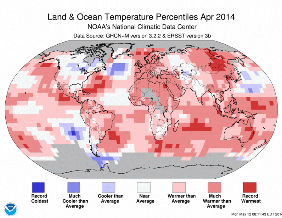
If there’s an aspect of global warming science that remains unsettled, it’s the general state of prediction and analysis over the fate of Northern Hemisphere sea ice. As is well known by now, model predictions greatly underestimated the pace of sea ice loss as a response to human-caused warming. Big melt years like 2007 and 2012 brought sea ice extent and area, by end 2012, to less than 50% of 1979 values. Sea ice volume for the same period was nearly 80% lower than 1979 measures. Such lows were generally not predicted to appear until the 2060s at the earliest.

Ice response to rapid human warming and polar amplification, in these cases, was, for lack of a better description, outrageously stunning. And the weather impacts of such amazing losses were increasingly dangerous and far-reaching. Climate systems inertia, in the case of sea ice, seemed to be no match at all for the strong and likely unprecedented warming forces we’d already unleashed.

Sifting through the sea ice tea leaves

Though much of what happened was and continues to be unexpected, a few overall patterns emerge in the data. Dynamic melt trends for area and extent were composed of massive melt years (2007 and 2012) followed by pseudo recovery years (2008, 2013) where the ice seemed to bounce back a little before inching again toward previous record lows (2009, 2010) or setting minor new melt records (2011 area) before the next big hit.

Sea ice volume measures were somewhat less messy with massive melt years (2007, 2010), more minor melt years (2011, 2012), one minor pseudo-recovery year (2008) and one major pseudo-recovery year (2013). In this set, one year (2009) stands out as neither showing a new record low volume nor showing pseudo-recovery as end season volume fell off slightly from the previous year. The fact that 2009 followed a pseudo-recovery year (2008) may or may not be instructive for the current melt season.

It is worth noting that in the volume progression, four out of seven years during the 2007 to 2013 period all showed new record lows.

Piomas Minimum Arctic Ice Volume

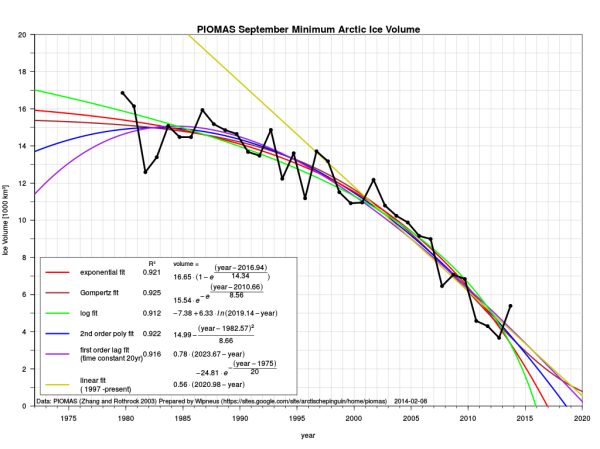
(Graph of minimum Arctic sea ice volume as measured by PIOMAS since 1979 with various trend line projections. Data source: PIOMAS Image source: Wipneus.)

What one can read from these data points is that strong pseudo-recovery years (like 2013 and 2008) have typically been followed in recent years by a return to the decline trend but not to new record lows. So, statistically, this is what we would expect for 2014.

That said, keep in mind that though it remains extraordinarily difficult to predict end sea ice states for any single year, the overall trend of major and unprecedented melt is most likely to continue and the window for a total sea ice loss by end season before 2020 remains wide open. Further, statistical analysis will, in every case, bow to emerging conditions on and beneath the ice.

Evolution of the early 2014 melt season

For the 2014 melt season, the fickle Arctic does not at all disappoint. By late April and early May of 2014, an extraordinarily warm winter period had wiped out most of the 2013 recovery in sea ice volume measures. By mid April, PIOMAS was showing volume in the range of second or third lowest year on record for the date.

By today, May 12, sea ice area and extent measures were in the range of 4th to 5th lowest on record with both measures approximately mirroring 2007 values for the date.

Given the potential for very rapid melt during June and July, as displayed in recent melt years, these values are within striking distance of new record lows should the weather conditions for rapid melt emerge.

Observed conditions for early to mid May 2014

It is worth noting that May does not generally tend to be a predictive month for sea ice loss. In most cases, it is more a bottleneck period where values tend to crunch together as the sea ice softens up but generally shows few breaks toward the more rapid melt trends typically seen in June or toward a slower melt due to weather that is less favorable for ice degradation.

That said, a few currently ongoing conditions may provide some strong indicators for how the 2014 melt season could progress.

High amplitude Jet Stream waves through Eastern Siberia, the Bering Sea and Alaska. A doggedly persistent weakness in the polar Jet Stream along an arc from East Siberia to Western Canada has resulted in much warmer than usual conditions for the Bering Sea, the Chukchi Sea and regions of the Beaufort adjacent to the Alaskan and Canadian coasts. Warm air originating over a pool of much hotter than normal water in the Northern Pacific just south of Alaska has continued to flow up through the Bering Sea, into the Chukchi, and over Alaska and Western Canada and on into the Beaufort.

Tracking this warm air flow resulted in a bit of incredulity as day after day observation showed the air continuing on through the Beaufort, past the North Pole zone, down over Svalbard and the Fram Strait, into the North Atlantic and finally being swept east in the strong cross-ocean wind pattern toward England and Ireland. In this way, air from 40 North Latitude in the Pacific jumped the pole to end up in the Atlantic near England.

A persistence of this weather pattern would have numerous and potential critical impacts for the Arctic during the summer of 2014. First, it would result in a constant pressure of warmer than usual conditions for sea ice along an arc from the Mackenzie Delta and Adjacent Canadian Arctic Archipelago to the East Siberian Sea. Warm winds would assault the ice from launching pads over warmer land masses in this zone, resulting in increased and early ice erosions.

Already, we can see such conditions emerging in the following MODIS satellite shots provided by NASA:

Mackenzie Delta May 11, 2014

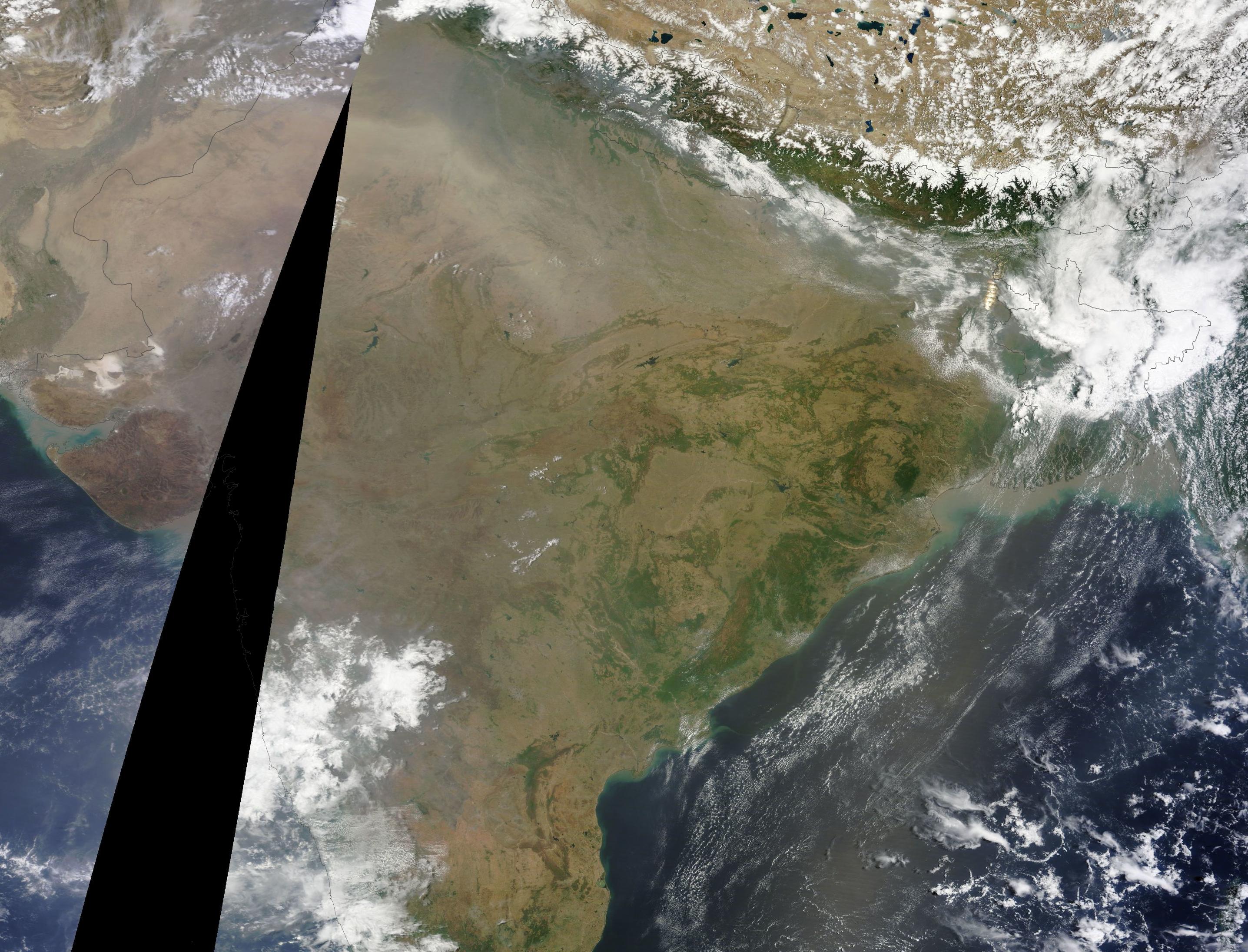
(The Mackenzie Delta [upper left] and adjacent Canadian Archipelago waters. Image source: LANCE-MODIS.)

The above image shows the Mackenzie Delta and the Canadian Arctic Archipelago on May 11 of 2014. In these images, we can seen the result of continued warm winds from the south and near-or-above freezing temperatures. For the Mackenzie Delta, temperatures since early May have ranged between 23 and 42 F, or between 5 and 25 F above average for this time of year. The high temperatures have brought the snow melt line all the way to the coast very early and have resulted in both ice melt and retarded refreeze in the broken ice and large polynyas offshore in the nearby Beaufort. Note that an additional heat influx to these coastal waters will occur once the shallow Mackenzie River fully melts, likely resulting in the early break-up of land-fast ice near the delta.

Chukchi Beaufort Melt May 11, 2014

(The Chukchi and Beaufort Seas on May 11, 2014 from the Bering Strait [upper left] to past Barrow, Alaska [lower center]. Image source: LANCE-MODIS.)

Further along the Canadian and Alaskan coasts, we find a continuation of sea ice weakness and break up in the off-shore regions north of Barrow Alaska and on into the Chukchi Sea. Large polynyas remain open throughout the region and exhibit no refreeze in the open water sections. Past the Bering Strait zone, Chukchi melt is very well advanced for early-to-mid May due to a combination of near constant warm southerly wind influx and an advancing warm water wedge through the Bering Strait.

This warm wind pattern through Eastern Siberia, Alaska and Canada and into the Arctic Ocean is reinforced by a combination of ongoing factors including a weakened polar Jet Stream which has tended to generate high amplitude ridges in this zone, a very warm pool of water in the Northern Pacific south of Alaska, and an emerging El Nino which historically has tended to push a high amplitude split in the Jet Stream up toward Alaska. These self-reinforcing factors make it likely that the overall pattern of warm southerly winds over the region will continue to persist and have an impact well into summer.

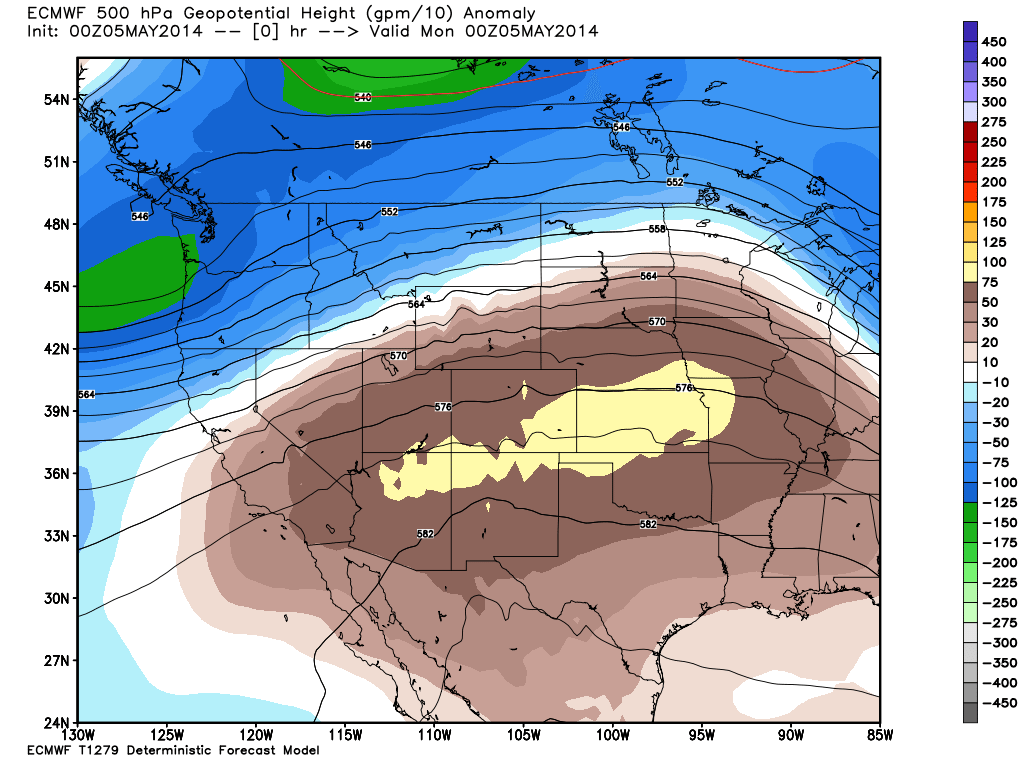
Finally, it is worth noting that the current and ongoing warm air influx through this region provides a constant source of energy for Arctic storm genesis, a factor that may well become more significant as melt season progresses. Forecasts for the next 24 hours show a storm pulling warm, above-freezing temperatures deep into the Beaufort as it begins a transition toward the northern polar zone. It is the second system to exhibit such anomalous warm air inflow and progression into the Central Arctic during the month of May.

GFS Warm Storm

(GFS model summary showing warm storm with associated above-freezing temperatures invading deep into the Beaufort Sea during late Monday and early Tuesday of this week. Image source: University of Maine.)

A third warm air invasion, this time from Eastern Siberia, and potential related storm development is also projected for late this week or early next week.

The Arctic dipole: storms over the Arctic Basin, high pressure over Greenland. Today, we track three Arctic low pressure systems — one emerging from the warm air influx over the Beaufort, one over the Laptev and one north and east of Svalbard. Greenland, meanwhile, shows a high pressure system centered almost directly over its large ice sheet. The net effect of these lows and highs is to funnel the warm wind streaming up from the Beaufort over the Northern polar zone near the Canadian Arctic Archipelago and out over the Fram Strait and Svalbard.

It is a dipole of high pressure over Greenland and low pressure over the Arctic Basin on the Central and Eastern Siberian side that has lasted for about two months through Northern Hemisphere Spring. This set-up creates a strong and consistent wind pressure providing transport of sea ice out of the Fram Strait. It is worth noting that Fram Strait export was one of the primary factors involved in the record low sea ice total seen during 2007, so a consistent dipole pattern of storms over the Arctic basin and highs over Greenland promoting ice export could well weigh heavily as melt season progresses.

Warming over Western Russia and Eastern Europe. A second zone showing consistent ridge development, polar Jet Stream weakness and coincident anomalous warming has emerged over western Russia and Eastern Europe. Such warming was seen during the weak El Nino of 2010 and resulted in severe heatwaves and wildfires for the region. A similar pattern has emerged in tandem with the rising and potentially far stronger 2014-2015 El Nino currently developing in the Eastern Pacific. Though it is too early to tell if this emerging hot zone will reach the extremes seen in 2010, this heat pool is likely to contribute warmth to sea ice zones in the Kara and Laptev Sea as the summer melt season progresses.

So far, Kara sea ice retreat has remained within usual boundaries for recent years. However, it is worth considering the potential strength of this developing warm air pool and how it may impact adjacent Arctic zones as May progresses into June. This week’s forecast now shows above-freezing temperatures predicted to progress into the Kara and 50 degree F readings predicted to push into estuaries bordering the Kara over the next few days.

Warm water upwelling, north wind flush, storm suction for Baffin Bay. Finally we come to Baffin Bay, a place many may well consider the Arctic Ocean’s red-headed stepchild. Over recent years, warm water up-welling, possibly driven in part by sea-bed methane release, in Northern Baffin Bay has resulted in an almost constant weakness and erosion of sea ice. This condition creates a bizarre circumstance in which Baffin is often surrounded by warmer waters north and south by late spring. This year is no exception. In addition, a north wind now appears to be flushing Baffin Bay sea ice toward the North Atlantic. The result is an expanding zone of ice-free water along the West Coast of Greenland pushing toward a widening gap in the north of Baffin Bay near the Nares Strait.

To the south, a persistent storm has developed near an anomalous cool zone in the North Atlantic waters off of Newfoundland. This cold pool is likely a residual of the continued dipole, hot-west, cold-east temperature anomaly over North America which has increasingly been squashed toward Newfoundland with the emergence of summer. The cold North Atlantic pool is also likely fed by a rising outflow of fresh, cold water from Greenland glaciers as well as the Baffin Bay ice export already described. A growing Gulf Stream weakening is also well established for the region.

The persistent storm is fed by high temperature differentials in the dipole zone. It is one of the remnant storm systems of this winter’s epic assault on the coasts of Great Britain — a possible precursor to even more vicious storms this coming winter.

But, today, the storm is simply providing added suction to drain ice out of Baffin Bay.

Storm off Greenland and Newfoundland

(Like a drain in a massive bathtub: storm off Greenland and Newfoundland on May 12 reinforces northerly wind flow pulling sea ice out of Baffin Bay. Image source: LANCE-MODIS.)

A final word on Storms and Warm Winds

During late April, we talked a bit about the impact of early season melt ponds on end-season sea ice levels. For recent scientific studies have found that early season melt pond formation has a high correlation with new record lows in sea ice area and extent.

But given the current very thin and broken state of sea ice, it’s worth considering whether the rules for sea ice loss aren’t in the process of changing.

Ever since the 2012 melt season’s close, the Arctic Ocean has exhibited a very battered sea ice state. One featuring widely disassociated packs of broken and brittle ice riddled with a long and pervasive spidering of leeds. For large melt pond systems to develop, the ice pack needs to be relatively contiguous. But the recent ice pack shows very little continuity and could, instead, be said to basically lack integrity. Such a state may well prevent a degree of melt pond formation in areas in which the ice is more and more highly disassociated into floes. And it is this disassociated ice state that may be the current and future norm as sea ice continues to thin and weaken.

In addition, rising temperatures in and around the Arctic have resulted in increased atmospheric water vapor content, increased cloud formation, and increased storm presence during summer periods. This progression toward storminess is consistent with paleoclimate studies showing that ice-free or near-ice-free Arctic states were much stormier than the current one. In the event of an expected stormier Arctic, melt pond formation may well result less from direct solar insolation through clear Arctic skies and more from an increasing number of rainfall and warm fog events over sea ice.

Cyclonic pumping of warmer waters from below the ice pack into surface water zones and the mixing of waters by waves generated by storm winds is also likely to have a far greater impact on sea ice melt than seen in recent years. It is likely we saw a prelude to just such an event during the great, late-season Arctic Cyclone of 2012 which sent waves the size of houses roaring across the Beaufort Sea to batter and disassemble the already weakened sea ice.

In this dynamic and changing system, warm winds are also likely to play a much greater role. Jet Stream erosion, in such a case, unleashes warm southerly winds on the sea ice. The winds, being warmer, hold a higher water vapor content than was typical for the Arctic prior to the human warming insult. Encountering ice and cold water, the water vapor in the winds condenses to form fog. The latent heat in the water vapor is thus released to do work melting the sea ice and warming the sea surface. In such cases, a kind of snow and ice eating mist develops from the warm wind — a blow torch for the sea ice.

Links:

LANCE-MODIS

Dual Ridges Form Sea Ice Achilles Heel for Summer 2014

University of Maine

PIOMAS

Wipneus

Cryosphere Today

NSIDC

Arctic Sea Ice Graphs

The Arctic Sea Ice Blog

The Storms of Arctic Warming

Ocean Heat Anomaly Spikes to New Extreme High of +1.16 C Above ‘Average’ on May 10, 2014

Ocean heat anomaly May 10 2014

(Global ocean surface temperature anomaly vs the 1979-2000 average. Data source: Global Forecast System Model. Image source: University of Maine.)

On May 10 global ocean surface temperatures hit a new extreme high for 2014 of +1.16 C above the already hotter than normal 1979-2000 average. This extraordinary temperature departure was driven in part by a warming of Equatorial Pacific waters to a +.59 C anomaly, putting that region in the range of a weak El Nino.

Overall, global ocean temperatures show very high positive anomalies in all regions with the mid-to-high latitude Northern Hemisphere oceans showing an extraordinary departure in the range of +1.36 C. Heat of particularly high anomaly values remains concentrated in surface zones in the North Pacific south of Alaska and in the Barents Sea, which over the past few years has displayed excessive warmth after a near permanent loss of seasonal sea ice cover. Hot spots in this zone continue to show +3 to +4 C above average temperature anomalies contributing to sea ice recession and weakness in the region east of Svalbard and on to the Laptev Sea.

An emerging Kelvin Wave off the West Coast of Ecuador has also created a high temperature anomaly hot spot in the range of +2.5 to +3.5 near the Nino 1 and 2 region. This expanding warm pool has been reinforced by broad area synoptic westerly winds counter to typical easterly trades which is pushing warm water toward the coasts of South and Central America.

Overall Equatorial Pacific Ocean temperatures in central and eastern zones have ranged between +.4 and +.7 C above average depending on region. Though these temperatures are in the range of El Nino, they will have to maintain or increase for a period of two months for an official state of El Nino to be declared.

It is worth noting that since the base-line for the GFS summary given above is in the 1979-2000 range, total departures from 1880 values are likely in the range of .3 to .4 C hotter, putting the actual global anomaly for the date at around +1.5 C.

In context, the swing toward a weak though still strengthening El Nino pattern is already starting to push global sea surface temperatures into or near the record range. We will continue to provide updates as the situation progresses.

Links:

Global Forecast System Model

University of Maine’s Climate Reanalyzer


Constant Arctic Heatwave Sends World’s Largest Ice Cap Hurtling Seaward

Svalbard. Until lately, a little-known locale situated between the previously frigid extreme North Atlantic and the Arctic Ocean about 500 miles east of Greenland. Typically a frozen island Archipelago, this pristine and sparsely inhabited redoubt has, over the past few years been ground zero for the assaults of an ongoing and extreme polar heat amplification.

During winters, temperatures in Svalbard are generally, well, Arctic. But in recent years abnormal winter warmth featuring temperatures ten, twenty, even thirty degrees above 20th century averages have been experienced with increasing frequency. This year, during one of the warmest winters on record for the Arctic, local Svalbard temperatures rocketed to as much as 40 degrees F above the usual range and for extended periods remained in the range of +20 to +30 F positive anomaly.

For all of February of 2014, the average temperature for this Arctic island chain was -1 C (about 30 F), a full 15 degrees C above average and a period that featured many readings at or above freezing. It was an unprecedented event for an island that features one of the largest ice caps on Earth.

Austfonna, Svalbard’s Ice Giant, Takes a Fall

Austfonna sprawls across the northeast section of Nordaustlandet, one of Svalbard’s many islands. The ice cap covers fully 8,000 square miles and features an ice dome pinnacle looming 750 meters high making it the largest of its ilk. Though not as grand as the great ice sheets of Greenland or West Antarctica, Austfonna still contains an immense amount of water. Less stable than ice sheets, deteriorating ice caps currently contribute to almost 50% of global sea level rise.

Austfonna Sentinel 1 Pace of Outlet

(ESA’s Sentinel provides false-color imagery of the Austfonna Ice Cap sliding into the Barents Sea. Right panel imagery provides observed changes in outlet speed from 1995, 2008, and 2014. Flow rates are indicated by color contour as slow [dark blue] to fast [red]. Image source: ESA via BBC.)

But Austfonna, the largest of these, was thought to be somewhat insulated from the insults plaguing most of the world’s ice caps. Its far northern and previously frigid location at Svalbard made it less vulnerable. But that was before sea ice loss opened the gates to an ongoing and ever-increasing assault of warm winds.

Now, according to findings made by the European Space Agency’s (ESA) Sentinel 1 Spacecraft, it appears that the ongoing assault of heat has at last destabilized the great Austfonna. For according to radar altimetry readings, the pace of the ice cap’s motion toward the Barents Sea has, over the past three years, accelerated to an extraordinary speed ten times more rapid than its previous pace (Sentinel’s findings are due to be published soon in a prominent scientific journal).

Lead study author Prof Andy Sheperd of Leeds University notes:

“We’ve observed Austfonna with various satellite radar datasets over the past 20 years, and it hasn’t done very much. But we’ve now looked at it again with the new Sentienl-1a spacecraft, and it’s clear it has speeded up quite considerably in the last two or three years. It is now flowing at least 10 times faster than previously measured.”

Austfonna is just the most recent of many very large ice caps, ice sheets, or glaciers now showing increasing rates of motion toward the world ocean. In many cases, once destabilized, these great bodies of frozen water have reached a point of no return as they lunge toward an inevitable destiny of melt, outflow, and disintegration. The most recent and ongoing rash of destabilizations are likely to have significant implications for global sea level rise due to human caused warming going forward. And with human heat forcing and amplifying Earth System feedbacks still on the rise, the glacial butcher tally isn’t likely to end any time soon.

Links

Sentinel Spies Ice Cap Speed-Up

Arctic Heat in Winter: February 2 Temperature Anomaly Hits + 13 F For Entire Arctic

ESA

Warm February Provides Extreme Record on Svalbard

Hat tip to Colorado Bob

California Experiencing Driest Year on Record, Epic Drought to Persist or Intensify Through Summer, Godzilla El Nino Waits in the Wings

8.83 inches. That’s the total average precipitation accumulation for the state of California so far for the first four months of this year. Out of the entire climate record, this paltry accumulation is less than that received during any similar period of any year since 1895.

Overall, rainfall totals throughout the state remained below 26 percent of typical levels for this time of year. And with California entering its third year of drought, the state would have to receive an average of 53 inches between now and October, more than 10 inches of rainfall each month, to break the current and very extreme ongoing drought.

May 6 drought monitor

(Drought monitor color graphic of California drought as of May 6. Tan = moderate drought. Orange = severe drought. Red = extreme drought. Dark Red = exceptional drought. Image source: Drought Monitor.)

As of late April, the drought had expanded to cover every corner of the state leaving not an inch of this critical agricultural region untouched. Drought continued to intensify, bringing with it water stress, cracked soil, crashing reservoirs and heavy strains to farms, businesses, cities and individuals. By May 6, fully 77 percent of California stifled under severe or extreme drought conditions.

The drought has become so severe that water-strapped cities like Santa Cruz have resorted to the most dire measures, including rationing, to husband dwindling water supplies. Last week, the city, which depends on some of the most vulnerable and thinly-stretched water resources in the state, announced a number of severe fines to water consumers exceeding assigned usage levels. The fines could quickly double, triple, or even quadruple water costs for any non-farm water consumer within the city.

Across the State, various desperate water conservation regimes have been put in place with the Federal Government announcing earlier this year that it would be forced to stop water allocations to farmers in an unprecedented move to stave off further declines in stores.

US Seasonal Drought Outlook

(US Seasonal Drought Outlook. Image source: CPC.)

Unfortunately, the persistent high pressure blocking pattern off the US West Coast, which has hovered in the same region for more than a year, remains in place even as it continues to deflect rain-bearing storms north toward the Washington and Canadian coasts.

This pattern — arising from a set of abnormal atmospheric conditions including added heating through human-caused warming and a Jet Stream that has the tendency to become stuck more and more often as sea ice erodes — results in a high likelihood that drought will remain or intensify for California and much of the US Southwest throughout this summer.

Climate Prediction Center analysis, shown above, projects that the current California drought will persist or worsen for the entire state through at least July 31rst. If relief does come, it will arrive many months from now. For the most likely chance for a change in the weather doesn’t appear until fall and winter of 2014. And this potential brings with it the risk for a radical switch to yet another damaging climate extreme.

Hoping For El Nino is Like Praying to Godzilla

Yesterday’s report from NOAA indicating a near 80 percent chance of El Nino by the end of this year provided some hope for additional rainfall after what is expected to be a very dry and difficult summer. But given current atmospheric conditions, the El Nino event would have to be in the moderate-to-strong range to both overcome what is a demonically persistent blocking pattern and to deliver enough moisture to make up the severe rainfall deficit. Anything less would be too weak to cure the current drought. But something stronger may well kill the patient.

Unfortunately, there remains a substantial risk that the 2014-2015 El Nino event could be a Godzilla of a thing — a monstrous outburst of the extreme ocean heat storage of the past 16 years that Dr. Kevin Trenberth has warned could well come back to haunt us. A record high ocean heat content that is out there, lurking in the Pacific Ocean even now. And it’s the potential that this heat will hit the surface with a severity rivaling or even exceeding the epic 1998 event that should well be cause for a different kind of concern.

ohc-2013

(Ocean heat content through 2013. Image source: Reanalysis of Global Ocean Heat Content.)

In such an instance, the onrush of heavy rains would be less a relief and more a switch from extreme drought to extreme flood. During the 1998 event more than 20 California counties were declared disaster areas due to the sudden deluge. But with human warming amping up the hydrological cycle by more than 6% and with such a large and vicious store of ocean heat waiting to be released, a severe El Nino at this stage might look more like an Arkstorm — an event which could dump many feet of rain over a period of weeks.

On the other hand, if the El Nino fizzles into only a minor event and that massive ocean heat store decides to lay in wait for another year or two or three, California is much more likely to remain locked in a continued multi-year dry pattern. So the best California could hope for is to thread an El Nino needle and receive a just-right moderate to strong El Nino. But with the current climate regime favoring extremes, the possibility for such a just-right occurrence is quite a bit lower than either the Godzilla or the fizzle.

In any case, both added heat and dryness are set to intensify over coming years and decades for California. This ongoing ratcheting is the direct result of human-caused climate change. A result that will either be bad or terrible depending on whether or not we decide to rapidly reduce and eliminate our greenhouse gas emissions.

Links:

Climate Outlook for Central California

Drought Monitor

CPC

Santa Cruz Rations Water

Farmers to Receive No Central Valley Water This Year From Feds

Dangerous Progress Toward Strong El Nino Continues

Reanalysis of Global Ocean Heat Content


Dangerous Progress Toward Strong El Nino Continues as Extreme Kelvin Wave Rises in Eastern Pacific

It’s happening. The most powerful sub surface warming of the Pacific Ocean on record is continuing to progress into the Eastern Pacific even as it rises toward the surface. As a result, risks for the emergence of El Nino during 2014 are spiking together with the potential for a host of global weather extremes.

Over the past month, trade winds remained weak even as west wind back bursts continued to push against the trades along the Equatorial Pacific. Moderate west winds emerged during mid-to-late April northeast of the Solomon Islands while cyclonic lows produced sporadic west winds in the Central Pacific. By May, consistent west winds were blowing over a large section of the Eastern Pacific.

Upper level easterlies had also emerged reinforcing a general pattern toward El Nino development.

The strong Kelvin wave that, in March, featured the highest sub-surface temperature anomalies on record entered its upwelling phase and began to push more and more of its heat potential toward the surface in the Eastern Pacific. This propagation is clearly visible in the sequence below:

Kelvin Wave Early May

(Kelvin Wave monitoring by NOAA. Image source: Climate Prediction Center.)

As of May 3, 2-3 C above average water temperatures had hit the surface of the Eastern Pacific and 3-6+ C above average temperatures lurked not far below.

The result of this rising warm water pulse was above average sea surface temperatures across the entire Equatorial Pacific with anomalies for the broader region hitting +.62 C on May 8th, 2014. It is worth noting that for El Nino to be declared, Equatorial Pacific water temperatures in the mid to eastern Pacific must remain above +.5 C for two months running. And, at this point, conditions appear primed for just such an event.

May 7 SST anomaly

(May 7, 2014 Sea Surface Temperature anomaly map shows Pacific Ocean looking more and more like an El Nino. Image source: NOAA ESRL.)

These clear ongoing trends have resulted in yet one more upgrade of El Nino potentials by the Climate Prediction Center (CPC) this week. Chances for El Nino in the current three month period of May, June and July have now been adjusted to about 55% with probabilities continuing to rise throughout the summer and fall. Peak chances for El Nino, according to CPC, are now just shy of 80% by October, November and December of 2014.

All values now show a very high degree of certainty that El Nino will emerge exceeding even the high confidence predictions provided last month by both NOAA and Australia’s Bureau of Meteorology (BOM).


El Nino Prediction Chart CPC May 8

(El Nino Prediction Chart as of May 8, 2014. Image source: CPC/IRI.)

CPC notes:

The model predictions of ENSO for this summer and beyond are indicating an increased likelihood of El Niño compared with those from last month. Most of the models indicate that ENSO-neutral (Niño-3.4 index between -0.5°C and 0.5°C) will persist through part of the remainder of the Northern Hemisphere spring 2014, most likely transitioning to El Niño during the summer. While ENSO-neutral is favored for Northern Hemisphere spring, the chance of El Niño increases during the remainder of the year, exceeding 65% during the summer.

When El Nino Comes Early, Risks of a Strong Event Increase

It usually takes until Fall or even Winter for a typical El Nino event to emerge. When El Nino comes early — by late spring or summer — risks increase that the event will be far stronger than normal. In general, such events are thought to be preceded by very strong Kelvin waves like the one we’ve witnessed since January.

Many Ocean researchers such as Dr Wenju Cai, a climate expert at Australia’s Commonwealth Scientific and Industrial Research Organisation, now consider the ocean to be primed for such a strong El Nino event.

Dr. Cai explains:

“I think this event has lots of characteristics with a strong El Nino. A strong El Nino appears early and we have seen this event over the last couple of months, which is unusual; the wind that has caused the warming is quite large and there is what we call the pre-conditioned effects, where you must have a lot of heat already in the system to have a big El Nino event.”

Rising Potential for Very Bad Weather

With the world’s weather already pushed to extreme states by human warming, the emergence of a strong El Nino would likely have increasingly severe consequences. Weather events at both the flood and drought extreme would be further amplified as a portion of hottest ever Pacific Ocean heat content transferred back to the atmosphere. This transfer would push a hydrological cycle already amped by more than 6% due to human-caused warming to a greater extreme. It would also likely result in new global high temperature records worldwide as a Pacific Ocean that had sucked up so much of excess human warming during the past decade and a half again becomes a major heat source.

Links:

NOAA’s Climate Prediction Center

NOAA ESRL

CPC/IRI

Ocean Data Points to Strong El Nino

Monster El Nino Emerging From the Depths

Hat tip to Colorado Bob

High Velocity Human Warming Coaxes Arctic Methane Monster’s Rapid Rise From Fens

Fens. A word that brings with it the mystic imagery of witch lights, Beowulfian countrysides, trolls, swamp gas, dragons. A sight of crumbling towers overlooking black waters. Now, it’s a word we can add to our already long list of amplifying Arctic feedbacks to human-caused warming. For the rapid formation of Arctic fens over the past decade has now been linked in a recent scientific study, at least in part, to a return to atmospheric methane increases since 2007.

Ribbed Fen

(A Ribbed Fen in Arctic Canada. Image source: The Government of Canada.)

The Role of Methane in Past Climate Change

Over the past 800,000 years, ice core records show atmospheric methane levels fluctuating between about 800 parts per billion during warm interglacial periods and about 400 parts per billion during the cold ice age periods. These fluctuations, in addition to atmospheric CO2 flux between 180 and 280 parts per million value were due to Earth Systems feedbacks driven by periods of increased solar heat forcing in the northern hemisphere polar region and back-swings due to periods of reduced solar heat forcing.

Apparently, added solar forcing at the poles during periodic changes in Earth’s orbit (called Milankovitch Cycles) resulted in a flood of greenhouse gasses from previously frozen lands and seas. This new flood amplified the small heat forcing applied by orbital changes to eventually break Earth out of cold ice age periods and push it back into warm interglacials.

Compared to current human warming, the pace of change at the time was slow, driving 4-6 degrees Celsius of global atmospheric heating over periods of around 8 to 20 thousand years. A small added amount of solar heat gradually leached out a significant volume of heat trapping gasses which, over the course of many centuries, undid the great grip of ice on our world.

Ice core record of Greenhouse Gas Flux

(Ice core record of greenhouse gas flux over the last 650,000 years. Methane flux is shown in the blue line that is second from the bottom. It is worth noting that current atmospheric methane values according to measures from the Mauna Loa Observatory are now in excess of 1840 parts per billion value. Temperature change is indicated in the lowest portion of the graph in the form of proxy measurements of atmospheric deuterium which provide a good correlation with surface temperature values. The gray shaded areas indicate the last 5 interglacial periods. Temperature year 0 is 1950. GHG year zero is 2006 in this graph. Image source: IPCC.)

By comparison, under business as usual human fossil fuel emissions combined with amplifying feedbacks from the Earth climate system (such as those seen in the fens now forming over thawing Arctic tundra), total warming could spike to an extraordinarily damaging level between 5 and 9 degrees Celsius just by the end of this century.

Methane — Comparatively Small Volume = Powerful Feedback

A combination of observation of past climates and tracking the ongoing alterations to our own world driven by human greenhouse gas emissions has given us an ever-clearer picture of how past climates might have changed. As Earth warmed, tundra thawed and ice sheets retreated releasing both CO2 and methane as ancient organic carbon stores, trapped in ice for thousands to millions of years, were partly liberated from the ice. In addition, warming seas likely liberated a portion of the sea bed methane store even as warming brought on a generally more active carbon cycle from the wider biosphere.

Overall, the added heat feedback from the increases in atmospheric methane to due these processes was about 50% that of the overall CO2 feedback, even though the volume of methane was about 200 times less. This disproportionately large share of heat forcing by volume is due to the fact that methane is about 80 times more efficient at trapping heat than CO2 over the course of 20 years.

A Problem of High Velocity Thaw

In the foreground of this comparatively rosy picture of gradual climate change driven by small changes in solar heat forcing setting off relatively more powerful amplifying greenhouse gas feedbacks, we run into a number of rather difficult problems.

The first is that the rate at which humans are adding greenhouse gasses to the atmosphere as an initial heat forcing is unprecedented in the geological record. Even the great tar basalts of the end Permian Extinction were no equal to the rate at which humans are now adding heat trapping gasses to the atmosphere. In just a short time, from 1880 to now, we’ve increased atmospheric CO2 by 120 parts per million to around 400 ppm and atmospheric methane by more than 1100 parts per billion to around 1840 parts per billion. The result is an atmospheric heat forcing not seen in at least the past 3 million years and possibly as far back as 10 million years (due to the radical increase in methane and other non CO2 heat trapping gasses).

This extraordinary pace of heat trapping gas increase has led to a very rapid pace of global atmospheric temperature increase of about .15 degrees Celsius per decade or about 30 times that of the end of the last ice age. As atmospheric heat increases are amplified at the poles and, in particular in the northern polar region, the areas with the greatest stores of previously frozen carbon are the ones seeing the fastest pace of warming. Siberia, for example, is warming at the rate of .4 C per decade. Overall, the Arctic has warmed by about 3 degrees Celsius since 1880 or nearly 4 times the pace of overall global warming.

arctic temperature increase since 1880 NASA

(Pace of Arctic warming since 1880 in degrees Fahrenheit based on reports from 137 Arctic observation stations over the period. Image source: Tamino. Data source: NOAA’s Global Historical Climatology Network.)

The result is that, over the past two decades, the Arctic has been warming at the pace of about .6 C (1 F)every ten years. And what we are seeing in conjunction with very rapid warming is an extraordinary high-velocity thaw. A thaw that is rapidly liberating stored organic carbon locked in tundra at a rate that may well have no rational geological corollary.

The Arctic Methane Monster and a Multiplication of Fens

So it is in this rather stark set of contexts that a study released in early May examining 71 wetlands around the globe found rapidly melting permafrost was resulting in the formation of an immense number of fens along the permafrost thaw boundary zone. Tundra melt in lowlands became both sources and traps for water. Such traps gained added water as atmospheric temperature increases held greater levels of humidity resulting in increased heavy rainfall events such as thunderstorms. These newly thawed and flooded fens, the study found, were emitting unexpectedly high volumes of methane gas.

From the methane standpoint, fens are a problem due to the fact that they are constantly wet. Whereas bogs may be wet, then dry, fens remain wet year-round. And since bacteria that break down the recently thawed organic carbon stores into methane thrive in a constantly wet environment the fens were found to be veritable methane factories. A powerful amplifying feedback loop that threatens to liberate a substantial portion of the approximately 1,500 gigatons of carbon stored in now melting tundra as the powerful heat trapper that is methane.

Mauna Loa Methane 1985 to 2014

(Mauna Loa methane levels 1985 to 2014. A return to rising atmospheric levels post 2007 is, in part, attributed to rapid tundra thaw and the formation of methane producing fens. Other significant new methane sources likely include sea bed methane from Arctic stores and rising human methane emissions due to expanding coal use and hydraulic fracturing. Image source: NOAA ESRL.)

By comparison, drier environments would result in the release of stored carbon as CO2, which would still provide a strong heat feedback, but no-where near as powerful as the rapid environmental forcing from a substantial methane release.

Lead study author Merritt Turetsky noted:

“Methane emissions are one example of a positive feedback between ecosystems and the climate system. The permafrost carbon feedback is one of the important and likely consequences of climate change, and it is certain to trigger additional warming. Even if we ceased all human emissions, permafrost would continue to thaw and release carbon into the atmosphere. Instead of reducing emissions, we currently are on track with the most dire scenario considered by the IPCC. There is no way to capture emissions from thawing permafrost as this carbon is released from soils across large regions of land in very remote spaces.”


Links:

A Synthesis of Methane Emissions From 71 Wetlands

Arctic Methane Emissions Certain to Trigger Warming

The Government of Canada

IPCC

NOAA’s Global Historical Climatology Network

More Cold Cherries

NOAA ESRL

Climatologist: Oklahoma is Burning. USDA Issues Dust Bowl Alert

Early May heat dome. A four word combination that may as well be a curse. And not something we would typically expect well before the height of summer. But that’s exactly what’s happened to the US from the southwest and on to its Heartland under a merciless regime of heat and drought fed by human-caused climate change.

As of Sunday, a high amplitude Jet Stream wave had formed over the Central US. The brief up-slope was enhanced by a number of unstable and powerful atmospheric dynamics. To the southwest, a warming Eastern Pacific lent energy from a growing pool of heat. To the north, from Arizona, to New Mexico, to Texas, to Oklahoma, lands baked by more than a decade of chronic drought provided almost no evaporative cooling as the atmospheric heat lens came into dangerous, greenhouse gas enhanced focus far overhead.

pressure anomaly

(ECMWF pressure anomaly graphic from Weatherbell Analytics showing a strong heat dome in place on Monday May 5, 2014.)

By Sunday and Monday, the heat dome was heavily entrenched and the result was a record flash heatwave for large swaths of Texas, Oklahoma, New Mexico, Kansas and Colorado. In Oklahoma alone, temperatures rocketed to above 100 degrees Fahrenheit at over 17 separate locations. One location experienced a 103 degree F reading, also the highest ever recorded for the date.

To the North, Wichita Kansas shattered its all-time record high temperature by a whopping 8 degrees spiking to an extreme of 102 F. Not only was the heat far stronger than normal. It came far earlier. For Wichita, the earliest 101 F or greater reading came on June 4 of 1933 with most years waiting until late June or early July for 100 F + readings.

For the Heartland, this flash heatwave was very much like the heat of July coming far too early. Across Oklahoma, multiple wildfires erupted from lands ravaged by the most recent event in a long spate of ever-increasing heat and dryness. The rapid rash of burning occurred in regions near homes and businesses forcing more than a thousand to flee.

This sudden, extreme and profound heat prompted Gary McManus, Oklahoma’s state climatologist to write: “Oklahoma is burning, both literally and figuratively, as a combination of drought, record heat, high winds and low relative humidity created the perfect wildfire conditions yesterday,” in the Oklahoma Climatological Survey’s online Ticker.

By early Tuesday, more than 30 structures were destroyed, one soul was lost, and over 6,000 acres had been consumed throughout the state. Though the fires of Sunday and Monday were mostly contained, conditions throughout the state remained hot, dry and dangerous with many more high temperature records expected to fall by late Tuesday afternoon. Mid-morning temperatures in many locations had already risen to the mid to upper 80s and more daily highs in the 90s and 100s were expected throughout the region.

NASA Oklahoma fires

(NASA shot of Oklahoma fires on May 4 and 5. Image source: GCarbin. Note that though highly anomalous, these fires are nowhere near as extreme as the powerful early season blazes affecting large swaths of Siberia this spring.)

Oklahoma governor Mary Fallin issued burn bans for almost half the state as firefighters predicted continued extreme fire potentials for the state throughout the week.

USDA issues Dust Bowl Warning

Meanwhile, US Department of Agriculture officials issued a warning Tuesday that conditions in the US Heartland were rapidly deteriorating along lines last seen during the infamous 1930s Dust Bowl as expectations for the US domestic winter wheat crop again fell after the USDA’s most recent agricultural tour.

Even prior to the extreme early May heatwave emerging over the Central US Sunday, Monday and Tuesday, the percent of the US wheat crop in either good or excellent condition had fallen another 2% to 31% late last week. Meanwhile, crops listed as ‘very poor’ rocketed from an already abysmal 34% to 39% over the same period. The net result is that the US wheat crop is in its worst condition since at least 1996, according to findings by Commerzbank analysts.

For Oklahoma, at the epicenter of current agricultural harm and flash heatwaves, only 6% of the state’s entire wheat crop was listed as in either good or excellent condition.

Department of Agriculture crop scouts described the Oklahoma situation in, perhaps, the starkest possible terms during their most recent report stating:

“Producers in the Panhandle continued to experience high winds … and low moisture conditions similar to the Dust Bowl in the 1930s.”

Overall, analysts now expect a US wheat crop of just 762 million bushels, the third lowest in 15 years despite record areas planted.

Conditions in Context

For the US, weather patterns continue to put the entire southwest and central regions under the gun for severe-to-extreme drought throughout much of the summer. The West Coast blocking pattern is now again firmly entrenched resulting in a deepening of already record drought conditions for California. Sierra Nevada snow packs have now fallen to less than 18% of typical early May values resulting in severe hazard for farmers and communities relying on this dwindling water supply. Arizona, Nevada and New Mexico are also likely to suffer from an extension of this severe and extraordinarily long-lived drought pattern.

Record low sierra nevada snowpack

(Greatly diminished Sierra Nevada snow pack as seen from satellite on May 4, 2014. Image source: LANCE-MODIS.)

In addition, a developing El Nino in the Eastern Pacific is likely to enhance already dry conditions over the US Heartland through the summer months. Together with the firmly re-entrenched west coast blocking pattern, conditions associated with El Nino set in place an extreme risk for a highly damaging return to drought for large sections of the United States this summer.

Globally, droughts continue to impact a number of the world’s previously most productive agricultural regions. In particular, both Brazil and India are currently suffering from extreme heat and/or drought. Argentina, one of the world’s top wheat producers is also hard-hit. Another one of the world’s largest grain exporters — the Ukraine — has recently been destabilized by a series of ills including east-west geopolitical tensions, internal division, and by Russian invasion. In this context, it is also worth noting that drought, fire, and flood have reduced Russian wheat production from 61 million tons in 2009 along a declining scale to 38 million tons in 2012.

Damages and risks to US crops are, therefore, not simply a national phenomena, but part of a much larger global context of ongoing and increasing crop damage due to extreme weather set off by human-caused climate change.

Links:

Oklahoma is Burning

Oklahoma Climatological Survey’s online Ticker

USDA Warns of Dust Bowl

Sierra Nevada Snow Pack Falls to 18% of Typical Values

LANCE-MODIS

GCarbin

Weatherbell Analytics

Hat tip to:

Colorado Bob

Todaysguestis

Jay M.