

(Monster Typhoon Haiyan Closes in on Philippines. Image source: NOAA)
Perfect symmetry. It’s a meteorological term that describes the structure of a classic hurricane. A perfect doughnut-shaped eye wall filled with clouds ranging from 50,000 to 60,000 feet height in all sectors circling swiftly around a deep and tiny central eye. In a textbook, the term perfect symmetry is innocuous. In an actual hurricane, the result is horrific.
As Haiyan did the seeming impossible and became better organized late Wednesday and early Thursday, a perfectly symmetrical eye wall developed over waters in excess of 80 degrees (F) and in an atmosphere boasting little or no wind sheer. By noon on Thursday, this perfect structure allowed more efficient evacuation of air through a deep and perfectly clear eye, pulling winds of ever-greater strength through its encircling storms. Explosive winds of a strength equivalent to a strong tornado, at 190 mph (US Navy showed 195 mph at 2 PM EDT), blasted around the storm’s center as its minimum pressure fell to 904.5 millibars — 40 millibars more intense than Hurricane Sandy (latest estimates show pressures as low as 858 mb, the lowest ever recorded).
Haiyan’s wind field is now the strongest measured in any hurricane since at least 1980, when Hurricane Allen briefly exploded to 190 mph intensity. The difference between Haiyan and Allen is that the storm’s fury was mostly vented on the open waters of the Caribbean and Gulf of Mexico. In contrast to Allen, it increasingly appears that Haiyan will peak in intensity right before impacting millions in the Philippines. Given the more recent measures, it is possible that Haiyan has left even Allen behind, surpassing even the strength of the strongest storms ever recorded — Camille and Tip.
It is difficult to overstate the danger of this situation. Haiyan is now more powerful that Andrew and Katrina. It is likely a rival of even Camile’s amazing intensity. All interests in the path of Haiyan should rapidly respond to any evacuation orders as this is an extraordinarily dangerous and powerful storm.
Haiyan is currently located about 100 miles east of the Philippine archipelago’s eastern edge. It’s very rapid forward motion of 25 mph will bring it over land within the next 4 hours. Over the next day, it should continue to churn over or near numerous Philippine islands before exiting the archipelago late Friday. Current forecasts predict Haiyan will maintain category 5 strength for much of this period, dropping to 150 mph, a strong category 4, as it exits the Philippines. Over the next few days, Haiyan is then expected to threaten Vietnam or southeast China as a strong category 2 or category 3 storm. (Haiyan made landfall near Guiuan at about 4 PM EST).

(NASA Modis shot of Haiyan early Thursday. Image source: NASA)
The above Modis shot shows Haiyan strengthening early Thursday morning as it began its final rush toward the Philippines.
Hot Ocean Waters in the Western Pacific Spawn 81 Cyclones for 2013
Very hot ocean waters ranging from 1 to 5 degrees Celsius above the 1980-2000 average throughout much of 2013 have spawned numerous severe weather events throughout the Western Pacific. On January 1rst, the first tropical cyclone of 2013 formed, not waiting even a day to begin what would prove to be an explosive, record season.
Throughout 2013, cyclones continued to form so that by November 81 cyclones had ripped through this region of the Pacific. Of this number, 38 storms were tropical depressions, 30 were tropical storms, and 13 were hurricanes. Four of these hurricanes were category 5 monsters.
During late summer a powerful tropical storm combined with a monsoonal flow to drench Manila in record rainfall, flooding much of the city. Other strong storms also impacted the Philippines, setting off landslides and numerous record flooding events. Haiyan is just the most recent and strongest example of a series of powerful storms impacting the vulnerable island chain.
Hot Pacific Ocean waters in a region north and west of the Philippines were also implicated in a major heatwave that resulted in scores of deaths throughout China, Korea, and Japan. This unprecedented ocean heat dome resulted in highest ever recorded temperatures with records being shattered consecutively, day after day, for up to two weeks in some locations.
Ocean heat temperature maps seem to be painting a bulls eye on the Western Pacific. And, for 2013, large swaths of water in this area continued to boast temperatures in excess of 90 degrees (F). This abnormally hot water enhanced evaporation and fueled various extreme weather events including the massive spate of tropical systems as well as the record floods seen in the Amur region of Russia and China.
As with many other extreme warming events, the regional warming seen in the western Pacific cannot be entirely separated from an ongoing global warming trend. August of 2013 boasted the world’s hottest ocean temperatures ever recorded. September 2013 tied 2005 for the hottest September on record. Extreme heating provides more energy for storms, droughts, and other extreme weather events. For each degree Celsius of global temperature increase, the hydrological cycle (the rate at which water evaporates and precipitates) increases by around 7 percent. Such an increase makes droughts more extreme even as it provides added heat and moisture fuel to increase the intensity of storms.
Many scientists are now attributing the increased strength of storms over the past decade and becoming particularly intense in recent years, to the ongoing and amplifying impacts of global warming. In this case, scientific conservatism is slowly giving way to both the observed impacts of global warming and a lengthening string of increasingly intense events that continues unabated.

(Seasonal Ocean Surface Temps, Average Value, August-November, 2013. Image Source: NOAA)
As seen in the above seasonal temperature graph, a large area of ocean surface waters have remained at or near 90 degrees (F) for an extended period. These temperatures are about .5 to 2 C (1-3 F) above the climatological average seen from 1980 to 2000. They are about 1-3 degrees C above averages seen in this region during the 1880s, as human greenhouse gas emissions began to ramp up. This pool of very hot water is enormous, larger than the land area of Australia, and it has continued to provide fuel for powerful weather events over most of the past year. Since hurricanes can form in water temperatures exceeding 75 degrees (F), this expanding warm water region is resulting in a near continuous energy potential for the development of these storms. And this hot pool of water will continue to warm as human greenhouse gasses continue to ramp up, likely eventually resulting in a time when the Hurricane season, at least for the Western Pacific, never comes to an end.
UPDATE:
Intensity observations, all now based on satellite, show no abatement of Haiyan’s impressive fury. Cloud heights, symmetry and lightning frequency in the eye wall still show an extraordinarily powerful storm. Current estimates have Haiyan maintaining 190 mph maximum sustained winds with gusts to 230 mph.These maximum wind totals are comparable to that of a powerful tornado, with the strongest hurricane wind field extending out 50 miles from Haiyan’s center.
Analysis at Weather Underground by Dr. Jeff Masters raises the possibility that Haiyan may now even rival Super Typhoon Tip’s record minimum central pressure of 870 millibars. If this were to case, Haiyan would be the most powerful storm on record. Since we have no direct observations, however, there is no way, as yet, to confirm this analysis. At the very least, it is likely that Haiyan rivals the most powerful storms on record since at least 1969 — Camille, Tip, and Allen.
Projected wind and rainfall intensity is provided by NOAA below:

(Image source: NOAA’s Environmental Modeling Center.)
Landfall storm surges of 15-20 feet with 15-25 wave heights are expected. Sea surface temperatures at 85 to 86 degrees (F) and near zero wind shear in the region are conducive for continued extreme storm intensity.
Rainfall totals are expected to exceed 8 inches along the path of travel and 50 miles out from the center. Consistent inundation with heavy rainfall events over recent months, including a recent tropical depression, have left the ground in areas along Haiyan’s projected path saturated and very vulnerable to flooding. So high risk of flash floods and landslides remain a serious threat. Expected rainfall totals are somewhat suppressed by Haiyan’s fast forward motion at 25 mph to the WNW. But rainfall in excess of 2 inches per hour is, nonetheless, likely to result in extreme flood risk.
Emergency management officials are urging millions to evacuate regions closest to Haiyan’s path. Manilia is expected to be grazed by the storm, experiencing tropical storm force winds and rainfall totals around 4-8 inches. Any deviation in Haiyan’s expected path could drastically change these forecasts.
Haiyan is more powerful than hurricane Megi, a 2010 storm that boasted 170 mph winds and resulted in hundreds of millions in damages and a heavy human toll.
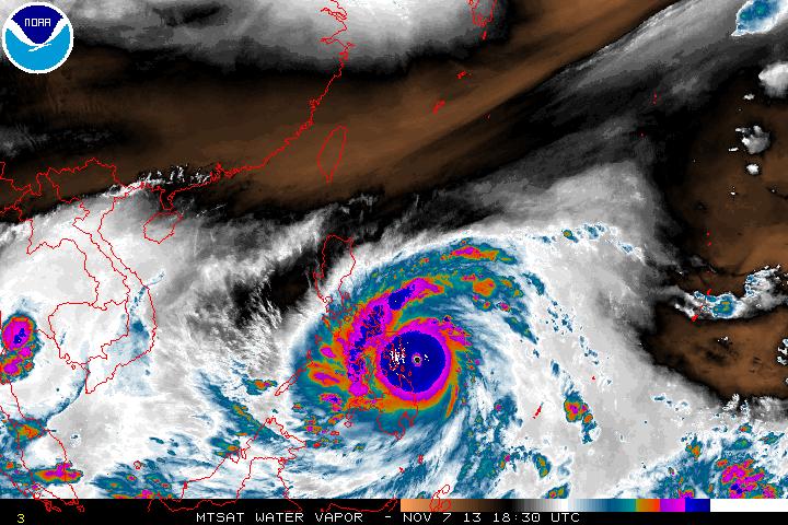
(Most recent water vapor shot. Image source: NOAA)
UPDATE:
Haiyan is now making landfall on the Guiuan Peninsula a coastal community with a population of 48,000. Preliminary pressures in the area are showing 992.5 mb. The storm’s strongest winds are now starting to impact the Eastern Philippines with Leyte, Tacloban, and Borongan in the bull’s eye. A wind speed measure one hour ago showed sustained winds in Guiuan at 96 mph. Winds in the area are likely much stronger now. Very tough 18-24 hours ahead.

(Image source: NOAA)
UPDATE:
Unconfirmed pressure reading at 889 mb via handheld near Guiuan at 5:01 AM. US Navy data showing 196 mph storm with 235 mph gusts and maximum significant wave heights of 50 feet 6 hours ago (H/T to Colorado Bob).
UPDATE:
Preliminary Satellite estimate shows Haiyan bottomed out at 858 mb minimun central pressure. Source: WGN Chicago. If true, this would make Haiyan the strongest storm ever recorded. Weather station in Guiuan no longer reporting. In all honesty, I wouldn’t be surprised if that little spit of land is all under water now.
The sun’s up. So you might want to take a look at this live shot of Boracay which lies almost directly in the path of this storm, which is still over 100 miles away from the camera’s location: http://www.earthcam.com/world/philippines/boracay/bolabogbay/
UPDATE:
NOAA reports that deep, warm water helped fuel Haiyan’s record intensity:
The intensification of Super Typhoon Haiyan is being fueled by “ideal” environmental conditions – namely low wind shear and warm ocean temperatures. Maximum sustained winds are currently at 195 mph, well above the Category 5 classification used for Atlantic and East Pacific hurricanes.
Plotted here is the average Tropical Cyclone Heat Potential product for October 28 – November 3, 2013, taken directly from NOAA View.
This dataset, developed by NOAA/AOML, shows the total amount of heat energy available for the storm to absorb, not just on the surface, but integrated through the water column. Deeper, warmer pools of water are colored purple, though any region colored from pink to purple has sufficient energy to fuel storm intensification. The dotted line represents the best-track and forecast data as of 16:00 UTC on November 7, 2013.
The extra depth of the warm water added further fuel for intensification because cyclones tend to churn up the water, bringing cooler water up from the deep ocean. This action tends to cause the storm to weaken over time, as it brings up cooler and cooler water or as it crosses the paths of other storms. But if water at depth is warmer, one key factor that can weaken storms is removed.
Yet more evidence of global warming at work. Read more here: http://www.nnvl.noaa.gov/MediaDetail2.php?MediaID=1452&MediaTypeID=1

(Oct 31 to Nov 31 Pacific Ocean Heat Intensity in Joules. Image source: NOAA)
UPDATE:
Yet another ‘perfect storm’ satellite shot of Haiyan. This one showing amazing stadium effect at landfall.

(Image source: MTSAT)
UPDATE:
Satellite imagery shows Haiyan passing into the central Philippines. Cloud tops are warming somewhat as the storm is disrupted by the surrounding land mass. Overall, this shows weakening and maximum sustained winds are now estimated to have fallen to around 185 mph or less with pressures rising to around 895 mb. Still a very intense storm, but at least one that is now showing some weakening.
UPDATE:
Haiyan exited the Philippines today as a 155 mph category 4 storm. Damage reports are now mostly sporadic. Currently, few have been able to access the hardest hit areas due to fallen trees blocking roads. It’s now around 1 am in the Philippines, so assessments of hardest hit regions will likely begin to trickle in later today. Most likely, the areas of highest impact were located within the eyewall itself — a 10-20 mile region directly surrounding the eye — and in areas near or close to where the storm made landfall. At its most intense the storm was estimated to have 195 mph maximum sustained winds. As the storm crosses the coast, this wind field tends to destabilize and form micro whirls which act in a manner similar to tornadoes. If the wind field was as strong as estimated, it is likely that tornado-like damage was inflicted directly in the path of the storm, especially within a 10-20 mile zone in the storm’s right-front quadrant.
Again, as yet, there have been few reports from the hardest hit regions due to difficulty accessing those zones and we will have to wait until daylight before gaining a more accurate assessment of the damage.
Forecasts are currently calling for Haiyan to slowly weaken as it moves over cooler waters. That said, it appears the storm will make landfall as a Category 2 storm in the region of Vietnam and Southeast Asia. There it is likely to emerge as a major rain event.
Links:
Weather Underground’s Must-Read Assessment
Ocean Heat Dome Steams Coastal China
Tropical Storm Combines with Monsoonal Flow to Dump 2 Feet of Rain on the Philippines


Colorado Bob
/ November 7, 2013The JTWC is reporting :
MAX SUSTAINED WINDS – 170 KT, GUSTS 205 KT.
196 mph , gusts 236 mph.
HAS TRACKED WESTWARD AT 21 KNOTS OVER THE PAST.
SIX HOURS. MAXIMUM SIGNIFICANT WAVE HEIGHT AT 071800Z IS 50 FEET.
Moving 24 mph.
LikeLike
Colorado Bob
/ November 7, 2013I looked at the TRMM satellite their latest images were yesterday as it approached Palau , it was raining 3.9 inches an hour around the eye wall . It went right over them , there are 21,000 souls on Palau. They’ve been living there for 3,000 years . Typhoons are rare, as Palau is outside the main typhoon zone.
http://trmm.gsfc.nasa.gov/
LikeLike
robertscribbler
/ November 7, 2013Yeah, getting a typhoon of this kind between 9 and 11 north latitude is pretty amazing.
LikeLike
Colorado Bob
/ November 7, 2013And last Dec. :
Bopha originated unusually close to the equator, becoming the second-most southerly Category 5 super typhoon, reaching a minimum latitude of 7.4°N on December 3.
http://en.wikipedia.org/wiki/Typhoon_Bopha
LikeLike
Colorado Bob
/ November 7, 2013Politically, Palau is a presidential republic in free association with the United States, which provides defense, funding, and access to social services.
http://en.wikipedia.org/wiki/Palau
LikeLike
Colorado Bob
/ November 7, 2013Wonder if the Tea Party will vote to aid Palau ?
LikeLike
robertscribbler
/ November 7, 2013Hah! Good one. Glad to see Kent C. gone from my home state of VA, though.
LikeLike
Colorado Bob
/ November 7, 2013You and Dr. Mann .
LikeLike
robertscribbler
/ November 7, 2013LOL. Perhaps we should send Mann letters of congrats for weathering that storm. Might have even been one to rival Haiyan.
LikeLike
Colorado Bob
/ November 7, 2013Lee Marvin was wounded on Palau. One of the longest, nastiest, and most worthless fights In the whole Pacific theater. Lord knows what evils from that time have been churned-up by this beast.
LikeLike
robertscribbler
/ November 7, 2013Ah, that’s a rough one. Another ugly island hop.
LikeLike
Colorado Bob
/ November 7, 2013Good God what a beautiful place –
https://www.google.com/search?q=palau+island&newwindow=1&safe=off&tbm=isch&tbo=u&source=univ&sa=X&ei=hQV8Up7AOuTgyQGDzoGoAg&sqi=2&ved=0CCwQsAQ&biw=1300&bih=662
LikeLike
robertscribbler
/ November 7, 2013Oh I’d love to be there. But not for one of these storms…
LikeLike
Colorado Bob
/ November 7, 2013Resigning the masthead , May I offer some advice ? Drop the dark background , keep the dark type with white highlights. I’ll go find you the perfect background. It’s from space, and it shows the thin shell of gases that save us from the cold dark space .
LikeLike
Colorado Bob
/ November 7, 2013Try this one :

LikeLike
Colorado Bob
/ November 8, 2013You love ravens ?
Make one your avatar .
LikeLike
robertscribbler
/ November 8, 2013Thanks for the good suggestions. But I think I’ll keep these. Ever hear of that tiny little magazine that launched a revolution? I had a part in that meme…
LikeLike
Colorado Bob
/ November 8, 2013Colorado Bob
Some good news, my constant bitching for months at Joe Romm’s site has born fruit…………….
Kristan Uhlenbrock is the Associate Director for Ocean Communications at the Center for American Progress.
Her first post :
Louisiana Permits Coal Terminal Adjacent To $300M Wetlands Restoration Project
http://thinkprogress.org/climate/2013/11/07/2901481/louisiana-coal-terminal-restoration/
Go over there , give her an “Atta Girl” .
LikeLike
Colorado Bob
/ November 8, 2013Why is this good news ? Because Climate Progress now has woman covering the oceans.
70 percent of the Earth’s surface. And they never had that before.
LikeLike
robertscribbler
/ November 8, 2013Well done!
LikeLike
Colorado Bob
/ November 8, 2013But she’s just this if we don’t help her :
The Under Assistant West Coast Promo Man
LikeLike
Patricia Shannon
/ November 8, 2013Thanks for providing excellent information
LikeLike
Colorado Bob
/ November 8, 2013Hurdy Gurdy Man –
LikeLike
Colorado Bob
/ November 8, 2013Down through all eternity
The crying of humanity.
‘Tis then when the Hurdy Gurdy Man
Comes singing songs of love,
Then when the Hurdy Gurdy Man
Comes singing songs of love.
LikeLike
james cole
/ November 9, 2013You can only wonder at how anyone in the direct path could survive. At it’s center, this storm is like a giant tornado. The pictures of it making landfall may be the signpost for future storms. It takes your breath away to see such a photo, it really looks like science fiction, not a real storm in the year 2013. I can only imagine what these storms will be in 50 years time! What future generations will face is worthy of biblical proportions. The global warming deniers will be out with their lies in a matter of minutes calling this storm typical and nothing unusual. Their willingness to let their children and grandchildren live in such a world shows how the narrow minded short term greed of 21st century economics has become inhuman.
LikeLike
Colorado Bob
/ November 11, 2013Bloomberg Industries is estimating insured damages of $2 billion and total economic damages of $14 billion, making Haiyan the most expensive natural disaster in Philippines history. This is the third time in the past 12 months the Philippines have set a new record for their most expensive natural disaster in history. The record was initially set by Typhoon Bopha of December 2012, with $1.7 billion in damage; that record was beaten by the $2.2 billion in damage done by the August 2013 floods on Luzon caused by moisture associated with Typhoon Trami.
http://www.wunderground.com/blog/JeffMasters/comment.html?entrynum=2576#commenttop
Typhoon Bopha had 175 mph winds.
Typhoon Trami. rained 32 inches just north of Manila.
LikeLike
Colorado Bob
/ November 13, 2013Robert –
Back to the oceans …………….
The sea star population has collapsed on the West Coast from Alaska, to San Diego . The virus killing dolphins has moved south, and may now be killing whales.
LikeLike
Colorado Bob
/ November 15, 2013More bad news from the oceans –
“WASHINGTON — Greenhouse gases are making the world’s oceans hot, sour and breathless, and the way those changes work together is creating a grimmer outlook for global waters, according to a new report Wednesday from 540 international scientists.
“
The world’s oceans are getting more acidic at an unprecedented rate, faster than at any time in the past 300 million years, the report said. But it’s how this interacts with other global warming impacts to waters that scientists say is getting them even more worried.
http://www.washingtonpost.com/politics/report-ocean-future-looks-grimmer-due-to-combination-of-acidity-warmth-and-lack-of-oxygen/2013/11/13/6e7d44ba-4cc0-11e3-bf60-c1ca136ae14a_story.html
LikeLike
Colorado Bob
/ November 18, 2013New video of the storm surge coming on shore last week , you won’t believe this @ 44 seconds into the clip –
LikeLike
Steve
/ November 19, 2013An Italian island just got hit by what one referred to as a “water bomb”. 17 inches of rain in 24 hours which was half of their average annual rainfall. http://news.yahoo.com/apocalyptic-storm-floods-sardinia-17-dead-112923772.html
LikeLike
Steve
/ November 19, 2013Robert or Bob, are these as uneventful as they make it sound? I’ve never heard of or saw such a cloud. http://news.yahoo.com/wild-roll-cloud-tumbles-across-texas-sky-154102952.html
LikeLike
Colorado Bob
/ November 20, 2013More bad news from the oceans –
Warming Oceans Lead to Zooplankton Decline
PORTLAND, Maine (AP) — The microscopic creatures that make up a critical link in the ocean food chain declined dramatically the first half of this year in the North Atlantic as ocean temperatures remained among the warmest on record, federal scientists say.
Springtime plankton blooms off the coast of northern New England were well below average this year, leading to the lowest levels ever seen for the tiny organisms that are essential to maintaining balance in the ocean food chain, said Kevin Friedland, a marine scientist with the National Oceanic and Atmospheric Administration.
http://www.ryot.org/warming-oceans-lead-zooplankton-decline/474849
LikeLike
Colorado Bob
/ November 23, 2013It’s Not Easy by the Rolling Stones
LikeLike
Colorado Bob
/ November 26, 2013New methane numbers coming from EAIS , they are double what we feared.
In 2010 Natalia Shakhova was in a fishing boat , off the Levan delta doing science. A storm came up 11 Russian sailors died coming to their rescue .
Somehow, her boat made it. The 11 men on the Russian tug coming to save them all died.
This is what one calls “Big Science” .
LikeLike
Colorado Bob
/ November 26, 2013The Arctic methane time bomb is bigger than scientists once thought and primed to blow, according to a study published today (Nov. 24) in the journal Nature Geo About 17 teragrams of methane, a potent greenhouse gas, escapes each year from a broad, shallow underwater platform called the East Siberian Arctic Shelf, said Natalia Shakova, lead study author and a biogeochemist at the University of Alaska, Fairbanks. A teragram is equal to about 1.1 million tons; the world emits about 500 million tons of methane every year from manmade and natural sources. The new measurement more than doubles the team’s earlier estimate of Siberian methane release, published in 2010 in the journaloscience”.
http://www.livescience.com/41476-more-arctic-seafloor-methane-found.html
LikeLike
Colorado Bob
/ November 26, 2013RS –
Great writers, need great material. As poor writer, I’m just throwing spam at the castle.
LikeLike
Colorado Bob
/ November 26, 2013It’s Not Easy by the Rolling Stones
Today we learned that Mick Jagger will become a great great grandfather.
LikeLike
Colorado Bob
/ November 26, 2013As the man said about the thaw in Churchill , it’s out of the freezer , and setting on the counter.
LikeLike