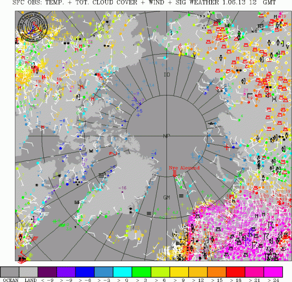
Over the past three days, a northward bulge in the polar Jet Stream has resulted in extraordinarily high temperatures over a large region of Scandinavia and Russia north of the Arctic Circle.
In Arctic Utsjoki, Finland temperatures Friday reached a scorching 87 degrees Fahrenheit, the highest temperature ever recorded for that city. At Inari and Ylitornio, temperatures exceeded 84 degrees, also a record highs. Saturday saw a spreading of hot air north and eastward into Russia with regions within 50 miles of Arctic sea ice recording temperatures near 80 degrees Fahrenheit.
Thoughout this broad region, record or near record high temperatures were breached as a pulse of hot air expanded north and eastward. Temperatures in the 80s were common for an area whose average highs for this time of year range in the high 30s to mid 40s.
You can see this powerful concentration of hot air on the Arctic map below:
(Image source: Uni Koeln)
See that vast region of pink in the lower left-hand corner of the map? There’s your heat wave.
Ever since 2007, loss of sea ice has had an increasing impact on the polar jet stream. Research first conducted by Dr. Jennifer Francis and confirmed by a growing body of climate scientists has found that loss of sea ice and summer snow cover results in a slower jet stream. This slowing of the jet causes it to dip and bulge in big north-south loops. This high amplitude meridonal flow can create blocking patterns that generate persistent weather over a given region. Where weather patterns may have lasted for days or weeks before, now they can last for months. Meanwhile, storms can also persist for longer periods over these regions.
A good explanation for this process is described by Dr. Francis in the below video:
A bulging blocking pattern in the region of Scandanavia and western Russia emerged last week and has since strengthened. This large bulge is dredging up and concentrating warmer air from the south and east and keeping it in place even as it gathers more heat.
You can see this bulge on the below map of the polar Jet Stream:
(Image Source: California Regional Weather Service)
The large bulge extends up from Norway toward the Greenland coastline, then cuts across Svalbard before flowing down into Russia.
Northern Hemisphere Jet Stream a Complete Mess
A cursory examination of this Jet Stream’s disposition over the Northern Hemisphere gives testament to how much of a mess it is. Huge dips, breaks, and vortices in the circumpolar wind flow are now common. In large areas, the wind speed has slowed to a crawl, giving the Jet its broken and scattered appearance. One other feature of note, which I’ll examine more in another blog, is the large dip running down through the central US. The persistence of this dip has resulted in a very stormy spring for the US midwest, depositing record rainfall in many regions even as it spawned one of the most damaging tornadoes in US history. So this visibly mangled jet stream is also implicated in extremely severe weather outbreaks in the US midwest.
Weather forecasts show a continuation of the weather pattern currently involved in Scandinavia’s heat wave at least through this weekend. We’ll have to wait to see if conditions persist beyond the current forecast and whether or not this heat becomes an imbedded pattern for this region over late spring and early summer.
Echoes of 2008?
The current heat wave is a few days earlier, quite a bit hotter, and far more widespread than a similar heat-wave that occurred during June 2-10 of 2008. This particular heat wave appeared after the 2007 season of record melt hammered the sea ice. Since 2012 was also a period of record low ice, one wonders if this particular late spring heat wave is related to major sea ice losses seen last year.
NASA provides an in-depth explanation of the 2008 event here. As you can see from the map below, high temperatures during the heat wave five years ago were not quite as hot and no-where near so wide-spread.
(Image source: NASA)
Indirect Implications For Sea Ice?
Forecast maps also show a finger of this warm air plunging deep into the Arctic. Should such an event occur, it could impact the sea ice from Svalbard and regions further north toward the pole. Models have shown the potential for temperatures of 5-10 degrees Celsius in this extreme northern region. Should high temps arise and persist, we can expect an accelerating impact on sea ice.
So long as hot air remains so wide-spread over Scandanavia and Russia, it can serve as a launching pad for warm air invasions of the Arctic as well as provide fuel for Arctic cyclones. So this weather situation is certainly one worth watching for potential future developments.
Links:


Matthew
/ November 4, 2016Nice post, nice maps and very interesting information’s, thank you.
LikeLike
robertscribbler
/ November 4, 2016Thanks Matthew. This is an old post, though. Certainly worth keeping track of for the purpose of Jet Stream observational research over the past few years. Best, Rob.
LikeLike