(Image source: Uni Koeln)
Yesterday in Alaska, as wildfires raged through interior regions, temperatures rose into the high 80s (Fahrenheit). Now, during relative night-time in the land of the midnight sun, lows are hovering around 70 in many places (near record daily highs for this time of year). Meanwhile, at the Arctic’s opposite end, temperatures in the region of Archangel, near the Arctic Ocean are in the range of 90 degrees. Nearby, Finland also sees temperatures rocketing up through the 80s as a Scandinavian heatwave that began in June reasserts itself.
The Arctic Heatwave: A Pervasive Feature for Summer 2013
The Arctic heatwave that started in Scandinavia then moved to Alaska and flared in Russia and Siberia has now become nearly ubiquitous. Record hot temperatures range the Arctic from shore to shore. These record heat invasions have been enabled by a combination of factors that include rising global greenhouse gasses, above average atmospheric methane and CO2 concentrations in the Arctic, and a rapid retreat of snow and sea ice cover that has enabled the Jet Stream to range further and further north, bringing temperatures from more southerly climates with it.
As a sample, atmospheric CO2 is now at about 403 parts per million at Barrow Alaska, while methane levels are around 1890 parts per billion. These levels are about 4 parts per million and 60 parts per billion above current global average CO2 and methane levels respectively. Higher levels of these heat trapping gasses in the Arctic are a direct result of environmental emissions sources including thawing tundra, melting permafrost, and destabilizing frozen methane on the Arctic sea bed. Together, these sources result in substantially higher levels of almost all greenhouse gasses over a broad range of the Arctic.
Extreme Jet Stream positions are also plainly visible today with a large, anomalous peak in the Jet Stream over Scandinavia and extending into Russia along with a fading, but still apparent, ‘heat dome’ high pressure system over central Alaska:
(Image source: California Regional Weather Service)
Both these features continue to bring much warmer than normal conditions in regions beneath their influence. The Scandinavian blocking pattern has been particularly persistent, with weather impacts stretching all the way back to early June. One last feature of note is a cut-off upper level low just off the Pacific coast of British Columbia. This particular low pressure system was the one that resulted in so much flooding over regions of Alberta and Calgary last week with rainy conditions persisting through today. A large band of clouds and rain storms continues to stream off this low, dumping more un-needed moisture over central Canada. Among today’s impacts was the flooding and shut-down of a meat-packing plant, yet one more ding to the world’s food supply.
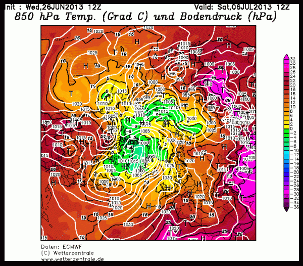
ECMWF forecast models show this rough configuration of the Jet Stream remaining in place at least until July 6th when the Scandinavian blocking pattern begins to stage a major warm-air breakthrough to the Central Arctic. At the same time, a large trough of low pressure systems emerges again over regions of Alberta and northern Canada as a ridge of high pressure shoves what remains of PAC 2013 over Greenland and comes to take tenuous hold of the Central Arctic.
(Image source: ECMWF)
Note the above freezing 5,000 foot temperatures plunging all the way through the Central Arctic (which should translate to around 40-45 degree [F] surface temperatures). It is also worth noting the large pulse of warm air riding all the way up to the Canadian Archipelago ahead of the developing trough.
This forecast is still very far out, so we’ll have to keep watch for any changes. Yet given the history of summer 2013 Arctic weather, it appears likely that the ongoing extreme configuration of the Jet will result in more unusual events.
As a final, I’ll leave you with this picture of the expanding open water at Barrow, Alaska. Note that the off-shore ice has been gone since June 24th.
(Image source: Barrow Sea Ice Cam)
Links:


bearspawprint
/ June 26, 2013May I reblog this?
LikeLike
robertscribbler
/ June 26, 2013Be my guest!
LikeLike
bearspawprint
/ June 26, 2013Thank you
LikeLike
bearspawprint
/ June 26, 2013Reblogged this on bearspawprint and commented:
Glacial breakout floods? Tundra into swamp?
LikeLike