

(Image source: California Regional Weather Service)
The Jet Stream over North America is a complete basket case. It is far less a river of air flowing between colder northern regions and warmer southern regions than it is a disassociated hodgepodge of cut off air flows. In the far north over a region of coastal Alaska and the Northwest Territory, an Arctic heat dome has formed and grown more prominent setting off temperatures ranging from the high 70s to high 80s as far north as the shores of the Arctic Ocean. This system, which has already lasted for nearly a week over this region is expected to persist until at least mid August as it ever so slowly drifts south and east. Over the west coast of the US, another cut off low sits almost motionless. Over a region between the Great Lakes and Hudson Bay a second upper level low meanders, drifting slowly west, if it moves at all. To the south, a large high pressure system also sits over the Gulf of Mexico. And from the east, a final low moves from east to west riding the tropical flow in toward Florida.
Between them all sits a stationary storm system that simply cannot move. And so it dumps rain day after day after day.
The Jet Stream is so weak over North America that these systems are essentially locked in place. And that means more persistent weather. In the case of Missouri and Tennessee, where these upper level systems are combining moisture flows from the southwest monsoons, the Pacific Ocean, from the Atlantic and from coastal and western Canada over a stalled frontal boundary, it means a great, daily dumping of rain.

(Image source: NOAA)
The net effect of these colliding and stagnate flows is a kind of storm sandwich that is focusing in on Missouri and Tennessee even as it spreads broader impacts over a twelve state region. You can clearly see these convergent and stationary systems in the water vapor image above provided by NOAA. Note the low pressure swirls off the US West Coast, in Canada, and off the US East Coast. You can also see numerous streams of moisture flowing from the Gulf of Mexico, from the monsoonal systems over Mexico and Texas, from the west coast low, and being pulled down through a still moderately active Jet Stream flow over western Canada. The swirl of whites and blues over the Central US represents an ocean of atmospheric moisture readying to dump yet more rain over Missouri, Tennessee and the central and eastern US.
Over the past week, satellite shots show persistent storms popping up again and again over the same region:


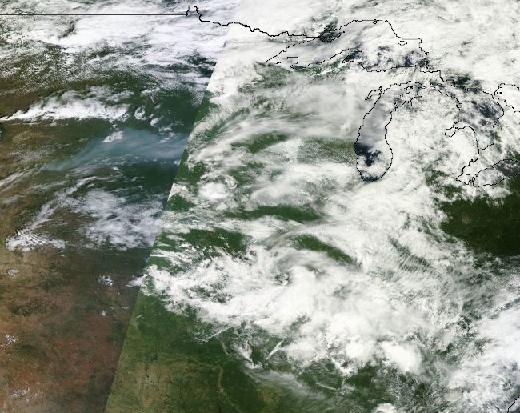

(Extreme rainfall over Central US from August 2 through August 7. Image source: NASA/Lance-Modis)
What this series of satellite shots represents is a constant, six day heavy storm pattern. Adding in the NOAA water vapor image above, it appears that today makes for day seven. And looking at the forecast, it appears this system is now set to expand eastward even as it continues to dump rain over already hard-hit ares.
The results of this continuous dumping of moisture over the Central US has been nothing less than staggering. In eastern Missouri, in a region near Fort Leonard Wood, over 14 inches of rain has fallen during the past week. Richland in central Missouri has received a whopping 17 inches. This massive dumping of rain represents the delivery of four months worth of precipitation in just six days. Brandon, another Missouri town, received a total of 8 inches of rain within the 24 hour period from Wednesday to Thursday. A broader region stretching from Kansas to Missouri and Arkansas and on through Tennessee received between 3 and 17 inches of rain over the same one week period. And a still larger area encompassing Georgia, the Carolinas, Alabama and Kentucky also experienced abnormally heavy rainfall, washed out roads, and destroyed houses.
In the west, rivers which, in some cases were near record low levels, surged to new record highs. The east, which has endured far above average precipitation since mid spring, saw already swollen rivers leap their banks.
According to AccuWeather:
The Gasconde River at Jerome, Mo., set a record high level of 31.81 feet, breaking the old record of 31.34 feet set on Dec. 5, 1982. A near-record crest is forecast by National Weather Service hydrologists farther downstream on the river at Rich Fountain, Mo.
[Meanwhile,] the Maries River in Missouri crested just below record levels.
These very intense periods of rain set off flash flooding that inundated roads and destroyed at least 50 homes. Hundreds of homes were also inundated over a broader area with residents forced to flee to roof tops as water levels rapidly rose. The scenes of highways flooded, homes inundated, rivers reaching record or near record levels, and people being forced to flee from raging flood waters repeated again and again in a large swath from Kansas stretching eastward to the Carolinas. In total, more than 12 states have been seriously impacted.
ABC News last night, in the below video, aptly described the hardest-hit areas as turning into ‘a water world.’ The coverage shows storm shocked residents staring in awe at lakes forming in roadways, being rescued from the roofs of their homes, or being forced to rescue heavy equipment from flash floods. One beleaguered Georgia resident, after watching flood waters sweep his dog away, states: “I can’t live here no more, I’m through…”
However in depth and accurate, the above video misses the broader overall storm context of stalling Jet Stream flows, cut off upper level lows, and converging upper level moisture streams. ‘Stationary front’ is, therefore, a shallow and inadequate explanation of the patterns involved. The reporters would have done well to interview Stu Ostro and Dr. Jennifer Francis as individuals who could give this very extreme event a proper context as it relates to ongoing changes in the world’s climate to include meandering Jet Streams triggered by loss of northern hemisphere snow cover and sea ice, an amping up of the hydrological cycle due to increased rates of evaporation and rainfall under a regime of rising temperatures, and powerful, dense high pressure systems arising from a thickening atmosphere that just want to sit in place for longer and longer periods. All these emerging factors combine to increase the likelihood of extreme, persistent weather patterns like the ongoing series of storms now driving major US floods.
Unfortunately, the forecast calls for this weather pattern to continue to dump rain over an expanding area. For today and tomorrow, a stretch from the US Midwest to the east coast is under the gun for additional heavy rainfall and powerful, sudden storms through at least the next four days. These weather systems aren’t moving and the powerful flows of moisture converging over the central and eastern US are predicted to remain in place. So it is likely that flooding will continue to intensify over the coming days.
Links:
California Regional Weather Service
(Hat tip to Commenter Steve)


childress
/ August 8, 2013What’s so frustrating about this new phenomenon is that (outside isolated coverage of each flash flood, disconnected from any larger climate narrative) it always gets mentioned in passing as ‘drought relief’ — even though, if my understanding is correct, the surface ground is so saturated by the second or third day (if not hour) in an event like this that all the water just flushes out towards the Gulf – wiping out some poor farmer’s crop along the way. And so complacent businessmen continue to inflate soy futures even as we’re learning the heartland will get hammered a second front for decades to come.
LikeLike
robertscribbler
/ August 8, 2013The pattern keeps switching from drought to flood and back again. And I couldn’t agree more that the lack of adequate context is infuriating.
LikeLike
james cole
/ August 8, 2013I think it is generally accepted that America’s heartland has more than it’s fair share of climate science deniers, it is fitting that these extreme events seem to occur on their home turf more and more often. One wonders when and if these visible and measurable events will have a mental impact. Especially the frequency of unheard of rain events is making an impact where I live. Last year we had a 24 hour rain event that produced between 10-22inches of rain in our region, depending on where you were. At my house we were in the 12 inch range, Many local remarked that this event might have been a sign of global warming. That is progress, but at a terrible price.
I note, as others have, that the US Media has gone into stealth mode when it comes to extreme events related to climate. On one day this summer out west about 300 homes burned down, CNN and MSNBC were silent! Even the weather channel barely touched the subject. And nowhere is there a word on the present Siberian firestorms, Alaska’s fires or Canada’s fires. US media said nothing about the record flash floods in Alberta Canada. Record after record is set every week it seems, and US Media is in total stealth mode. As the global warming becomes more and more evident and provable, the less and less the US media touches the subject and the more strident the deniers become.
This is really Orwellian in nature, if you are familiar with how media was played in that world of “1984”.
LikeLike
jcl64
/ August 9, 2013Keep sending letters to the media houses about what they forgot to cover. I constantly do for our local news station which has been completely absent mentioning the serious melting of the west Greenland ice sheet, and neither mentioned the many wildfires in Russia going on as we speak. Whenever possible also post copies of these letters on blogs or places where you can show publicly this action and the lack of followup from the news corps.
LikeLike
robertscribbler
/ August 9, 2013This is an excellent response. Thanks for posting.
LikeLike
prokaryotes
/ August 8, 2013Reblogged this on Climate Force.
LikeLike
prokaryotes
/ August 8, 2013The above ABC video in HD http://youtu.be/aZ6s002L5kQ
LikeLike
prokaryotes
/ August 9, 2013Earth Under Water – Worldwide Flooding | Global Warming | National Geographic Documentary http://climatestate.com/2013/08/09/earth-under-water-worldwide-flooding-global-warming-national-geographic-documentary/
LikeLike
Steve
/ August 9, 2013Blistering heat wave continues in China and hits Europe as well. Several all time high’s were set, some of them breaking records that were 3 days old! http://www.wunderground.com/blog/weatherhistorian/comment.html?entrynum=183
LikeLike
Luke Orsborne
/ August 10, 2013If people are not made adequately aware of what is taking place, there is the real danger that in the face of social decline, government preparation for disaster in the form of persistent surveillance and the militarization of local police forces through DHS grants since 9/11, alongside legislation like the 2012 NDAA which has now made legal the indefinite detention of US citizens, will come together to create an attempted violent containment of citizenry on the brink. James Cole wonders if people will finally get it when extreme weather persists, but there will also be those who will actually blame the elitist and deviant “liberal” intellectual class for their Godless ways, and that extreme weather is in fact an act of divine retribution. If you are not familiar with Police Chief Mark Kessler, I urge you to watch some of his videos and realize that this is the type of person who will be running around, in a position of authority, when things further break down.
LikeLike