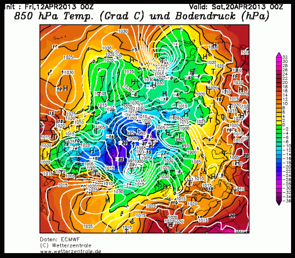
(Weather model showing forecast temperature, high and low pressure for April 20. What this clover-leaf pattern roughly represents is the new ‘normal’ shape of the jet stream. Image source: here)
The UK Met recently called an emergency meeting with the world’s top climate scientists to discuss how melting polar ice is radically altering that country’s weather. A permanent blocking high pressure system has formed over Greenland. This high has, effectively, caused the Arctic to invade the UK with increasing ferocity. The state is now so extreme that the Met is calling a meeting of the world’s climate experts to discuss what the future may hold.
Dr. Slingo, Britain’s top climate scientist notes how persistent high pressure systems are blocking the polar wind pattern from moving. What this means is that the weather simply cannot change. Increasingly, the UK has become a part of the Arctic. Slingo noted to ITV News:
If this is how climate change could manifest itself, then we need to understand that as a matter of urgency.
This meeting’s discussion will likely focus on how melting polar ice is dramatically altering the north polar jet stream and what future changes we can expect as sea ice continues to erode. Over the past year, Dr. Jennifer Francis has issued increasingly clear warning about the potential for extreme weather events due to polar sea ice erosion. Her warnings were then punctuated by an amazing and freakish superstorm: Sandy.
This winter, the increasingly powerful blocking high pumped warmer air into the Arctic even as typical Arctic weather was flushed south into the UK and Europe.
The New Clover-Leaf Jet Stream
In understanding this phenomena, it is important, first, to understand what is normal. During the 20th century, the polar jet stream ran swiftly around the northern hemisphere. For the most part, it served as the border between temperate regions of relatively warmer, milder climates and the much colder Arctic environment. This rapid jet served to keep colder air trapped in the Arctic and warmer air confined primarily to the south. Ripples in this jet stream were mild, looking almost like the wavy pattern of a stylized upside down fruit bowl. Invasions of warm air to the north and cold air to the south were rare and often resulted in strong storms that were then noted as ‘extreme’ weather events.
Today, things are radically different. Looking at the image above, we can see that the jet stream looks more like a mangled clover leaf than a gracefully arching bowl. This increasing clover leaf pattern is a result of a number of atmospheric dynamics. The first is that sea ice and Greenland ice are dramatically melting. Sea ice volume is 80 percent lower than it was in 1980 and Greenland is losing water at the rate of 250 cubic kilometers every year. This ice has an amazing ability to keep cold air locked in place, keeping the Arctic colder and, importantly, driving the jet stream to faster speeds. But, with the loss of this ice, the temperature difference between the Arctic and the southern latitudes is lessened. With more warmth in the Arctic, the jet stream has tended to slow down, meandering in these great, clover-like dips and whirls.
As the jet stream dips and whirls it tends to get stuck, staying in the same shape over the same location for long periods of time. This shape change is the result of certain features that push the jet into this new pattern. One is that more cold, reflective ice is in Greenland now than over the north pole. The result is that high pressure systems tend to form over Greenland rather than the north pole itself. The formation of this Greenland high many hundreds of miles to the south has severe weather implications for the UK and the rest of Europe. What it means, primarily, is much colder, stormier winters for Europe.
In other regions, warm air floods northward creating heatwaves. This was particularly true for the US during winter/spring of 2012. But an area not often mentioned is the west coast of Greenland and Baffin Bay which has experienced temperature averages more than 3 degrees Celsius hotter than normal for the entire winter. Last summer was also extraordinarily hot for Greenland, resulting in a record 150 year melt. In the above image, you can see these warm air invasions in the form of yellow and orange fingers pushing into the space of the colder greens and blues.
The new clover-leaf jet stream will not be easy for humans to manage. It will mean more persistent weather in a given region. And, if conditions are extreme, they will stay extreme for longer periods. More heatwaves, more cold snaps. More storms in areas where storms have become more prevalent.
Ironically, the new clover leaf jet stream causes one more self-reinforcing impact. It transports more warmer air into the Arctic. As such, it enhances the melt of ice which was the initial driver of extreme weather patterns in the first place. So, in this case, extreme conditions have the potential to snowball with a mangled jet stream resulting in more ice melt and more ice melt resulting in more extreme weather.
One last word and one last thing to think about. More and more the weather patterns resemble those roughly described by scientists as a Heinrich Event. Such events were characterized by rapid Arctic ice melt and resulting extreme weather and climate shifts. So it might be useful for climate scientists and the UK to discuss these geological events in the context of potential future weather. Because the UK, Europe and the rest of the world appear to be at the start of just such an event. The difference between this event and past events in the geological past is that the human forcing driving it is much greater than the previous natural forces that caused such changes. So it would be naive of us to hope that the current event will not also be more extreme than those seen in the past.
Links:


Sourabh
/ April 12, 2013“This shape change is the result of certain features that push the jet into this new pattern. One is that more cold, reflective ice is in Greenland now than over the north pole. The result is that high pressure systems tend to form over Greenland rather than the north pole itself”
Interesting. could you talk more about such features? I want to know HOW melting of ice affecting all these features/factors ? How less ice creating high/low pressure systems?
Its a climatology question, but I haven’t been able to find a simple cause-effect explanation for this phenomenon. I would really appreciate if you could help me understand cause-effect relationship.
Thanks,
Sourabh
LikeLike
robertscribbler
/ April 12, 2013The simple answer to this question is that colder air tends to form surface high pressure systems and that the center of colder Arctic air has tended to shift toward Greenland and away from the north pole as sea ice has become thinner and less stable. So even though Greenland is many degrees warmer than usual, it is becoming the coldest place in the Arctic and so high pressures have, more persistently formed over its colder ice sheets.
Another dynamic pushing this pattern is a tendency of low pressure troughs to form in the north Atlantic due to the new jet stream dynamic. I would expect the North Atlantic low and the Greenland High to become ever more persistent features as sea ice continues to erode.
You may want to take a look at the works by Dr. Jennifer Francis of Rutgers if you haven’t already. She provides a good explanation of these dynamics.
Hopefully, a good answer to your question.
-R
LikeLike
Sourabh
/ April 12, 2013Thanks Roberts,
I have seen her some of the video in which she explained some of these dynamics. I think I lack background knowledge/understanding of climatology/weather. Therefore, I am having trouble understanding these weather patterns.
Maybe I should start looking into basics of Jet stream, so that I can understand its dynamics and how it is affected by loss of ice.
~Sourabh
LikeLike