

Polar and tropical air masses setting up for another collision?
(Image source: NOAA)
In the southeast this year, rain follows rain follows rain. Now a tropical system may be preparing to add its own moisture to the already very wet mix.
The river of upper level airflow called the Jet Stream begins an almost due south movement at the Arctic Circle near the Northwest Territory and Canadian Arctic Archipelago. The atmospheric river dives down over Central Canada and into the Great Lakes region. Continuing ever southward, it finally encounters a wall of warmer air setting up near the south Tennessee border where it speeds up and turns eastward, joining another Jet Stream flow coming in over the Rockies.
Riding along these convergent Arctic and Pacific Jet Stream flows are a number of wet and stormy impulses. Because this deep north to south dip has been in place over the Eastern and Central US for much of the summer, storm after storm has continued to impact a large region from Missouri to New Jersey southward through the Carolinas and then again southwestward along through Georgia and the Gulf Coast states. This persistent stormy pattern, a result of a slow, wavy, stuck Jet Stream, which is, in turn, caused by sea ice and snowfall loss in the Arctic, has pushed rainfall totals 20 inches or more above the yearly normal in some locations. It has delivered extraordinarily moist storms that dump inches of rainfall in just a few hours. And it resulted in some regions of Missouri receiving four months worth of rainfall in just one week.
In the above water vapor image, provided by NOAA, you can see the storms riding along the south frontal boundary of this Jet Stream trough through the Dakotas, Montana, Nebraska and Colorado then down into Texas, turning eastward through the Gulf Coast States and then surging north along the US East Coast.
Yesterday, this pattern delivered a powerful storm complex to Pennsylvania and New Jersey — flooding roads, knocking out power and dumping as much as six inches of rain. Now, the Jet Stream has driven further south, pushing the frontal boundary over the Gulf Coast and US Southeast.

Mangled Jet Stream trough over eastern US.
(Image source: California Regional Weather Server)
But as if the convergent flows of the Jet Stream delivering very powerful storms, as if the stuck weather pattern keeping this storm-delivering trough over the Eastern US for months, and as if the human-added atmospheric heat amping up the hydrological cycle and spurring more intense rain events were all not enough, we now have a large, moist tropical weather system moving in and threatening to become entangled in an already very wet pattern.
As of this morning, the National Hurricane Center had issued an advisory for a tropical system in the western Caribbean predicting a 60% likelihood of tropical storm formation over the next several days. The system is a large, sprawling and disorganized mass of thunderstorms and moisture moving toward the north-west at 10 to 15 mph. A circulation appears to be trying to form in a region near the densest thunderstorms. The system is predicted to move toward the northwest until it is eventually captured by the frontal boundary at the leading edge of our deeply sagging Jet Stream. Should this mix-up occur, a tropical weather system and potential tropical cyclone will have again combined with an Arctic originating air-mass over the Eastern US, setting the stage for a rather intense and widespread rainfall event.
If there are some reading this analysis and thinking that it rhymes somewhat with set up for Superstorm Sandy, they wouldn’t be entirely off the mark. Until recently, it was less likely that tropical systems would combine with polar originating air masses over the US. The troughs originated and faded rapidly, only infrequently coming into dramatic collisions. But now, with the Jet Stream increasingly settling into a stuck pattern (spurred by human caused warming and sea ice loss) and seeming to favor trough development over the continental US and not over the ocean, such collisions are far more likely.
With the current system, unlike Sandy, rain appears to be the primary concern for now — not storm hybridization, expansion, and superstorm development. These are not on the radar. But we are still very early in storm development and we don’t yet know how powerful the slowly organizing tropical system will become. What we have right now is a large, and potentially strengthening package of tropical moisture setting its sights on an already soaked US southeast.

Very Moist Developing Cyclone Setting Sights on Southeastern US.
(Image source: The National Hurricane Center)
So the risks at the moment are for a potential major flooding event on the five to seven day horizon as the tropical system continues to track northwestward until it is pulled into the stormy flow of the Jet Stream trough. At that point, it is predicted to dump a heavy load of moisture and rain over the US southeast.
Current predictions from NOAA reflect uncertainty in storm development and track and, at the moment, call for 3-5 inches of rainfall from the Gulf Coast States through Georgia and the Carolinas over the next 5-7 days. Local amounts, however, could be much higher, on the order of 8 inches or more. Such an event would intensify an already severe flood problem over this large area, likely resulting in major and widespread flooding.

NOAA rainfall predictions over the next week.
(Image source: NOAA)
Any significant wind field of 40 mph or more would also likely result in a mass of fallen trees. The ground in this region is saturated with moisture, making it harder for tree root systems to grip the soil. So it takes much less wind to blow them down. Widespread power outages due to trees falling over power lines is, therefore, also a potential threat for this system.
Given the current position of the Jet Stream and uncertainty over potential storm strength and track, this situation could rapidly develop into a dangerous event for the southeastern US or we could end up with a storm system making landfall closer to Texas and Mexico. So we’ll be closely watching storm strength and path over the coming week.
UPDATE:
Tropical weather system 92 L is starting to exhibit some cyclonic turning:

92 L Shows Cyclonic Turning
Links:
California Regional Weather Server
Read Jeff Master’s Assessment Here
Why Do I Call it a Mangled Jet Stream? Learn More Here.


prokaryotes
/ August 14, 2013Reblogged this on Climate Force.
LikeLike
prokaryotes
/ August 14, 2013Advanced hydrologic prediction service
This image shows the departure from normal precipiation (today compared to the last 30 years – 30 Year PRISM Normals Have Been Updated)
http://water.weather.gov/precip/index.php?yday=1323734400&yday_analysis=0&layer%5B%5D=0&layer%5B%5D=1&timetype=RECENT&loctype=STATE&units=metric&timeframe=year2date&product=dep_normal&loc=conus
Tick “Archive: Month/Year” to see the last month precipitation.
LikeLike
prokaryotes
/ August 14, 2013US Midwest – Jet Stream delivers Dangerous Flash Floods – “A Water World” (August 2013) http://climatestate.com/2013/08/09/us-midwest-jet-stream-delivers-dangerous-flash-floods-a-water-world-august-2013/
LikeLike
prokaryotes
/ August 14, 2013More flooding footage from around the world from this month http://www.youtube.com/watch?v=YzNEBA9Cl7U Though the author includes meteor strikes and mentions the debunked cosmic ray theory in the video…
LikeLike
prokaryotes
/ August 15, 2013Climatic Schizophrenia: Despite One of Wettest Julys in United States, Drought Conditions Expand http://blogs.discovermagazine.com/imageo/2013/08/14/climatic-schizophrenia-in-july-fifth-wettest-on-record-drought-conditions-expanded/
LikeLike
Colorado Bob
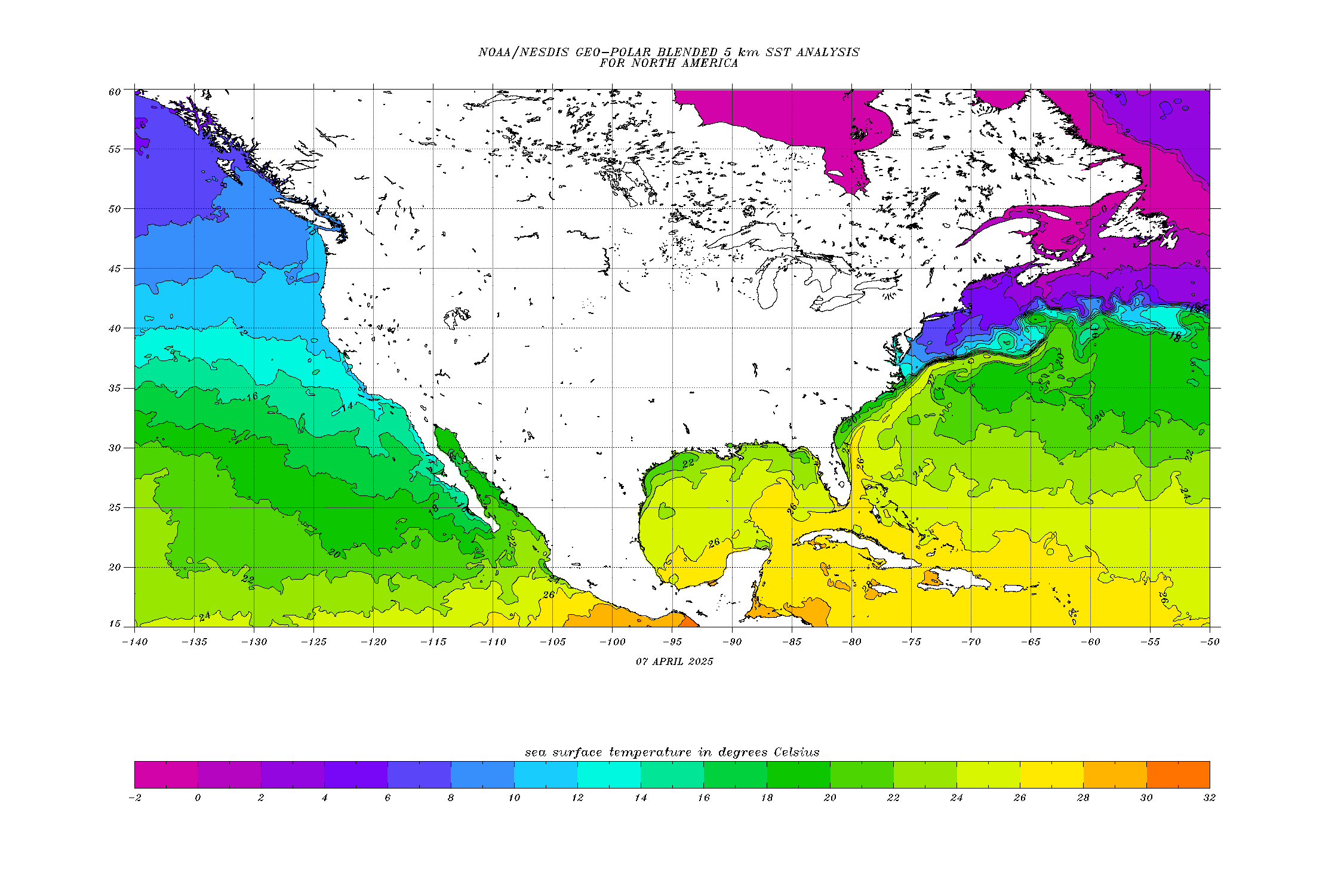
/ August 15, 2013The SST chart 8-13-2013 –
LikeLike
Colm Nolan
/ August 16, 2013Good analysis of weather patterns …. There are many factors at play and possibly a much bigger picture here in far this is the first of may turn out to be a winter of so called ‘Super storms’ . Our science relates to this planet as having a series of usually isolated weather events that collide for some reason (s). The simple law of cause and effect is understood in a very narrow way and excludes the possibility this planet has a consciousness that operates under the same law but at a far more elevated level. The possibility that that our attitude towards our host ( home) planet is ring fenced by the thinking that we can take and not be concerned with the consequential outcomes…. Be it in our actions or the thought forms we entertain…
The picture is far greater and simpler than our scientific analysis would present.
Thank you for your engaging blog.
Colm
LikeLike
Steve
/ August 17, 2013I noticed this morning that the jet stream has taken a dive all the way down into the Gulf of Mexico. How uncommon is that?
LikeLike
robertscribbler
/ August 17, 2013It happens now and then, but usually in winter. Not at all normal for summertime.
LikeLike
steve
/ August 17, 2013How about Billings Montana having their forecasted high being 32 degrees warmer than Atlanta Georgia in August? And Fox news was ridiculing people who believe in climate change this morning. Words can’t describe how baffled I am in the lack of concern by the masses. It’s going to take more than I ever would have guessed to get the public’s attention. I’m going to pull a muscle in my neck with as much as I shake my head at what is taking place.
LikeLike
robertscribbler
/ August 17, 2013If you look at the Jet, it flows almost due north over the US west and penetrates far into Canada before making a hairpin turn almost due south and plunging all the way to the Gulf of Mexico. That configuration is not at all normal.
As for Fox News it’s just Rupert Murdoch and his ilk attempting to inflict their fossil fuel brand of stupidity on the rest of us. Anyone still watching and believing Fox News long ago ceded any form of intelligence or independent thought and are now little more than political pawns for an ugly and selfish agenda.
LikeLike