
Heat just keeps flooding into the Arctic. And as late winter progresses to early spring, this inexorable influx of warmth may have profound impacts to both world weather and to the eventual state of sea ice by the end of summer 2014.
After a record warmth event shattered all time high temperatures across Alaska and resulted in melt-spurred avalanches that cut off Valdez from the mainland, heat in the high Arctic continued to intensify through late Sunday. According to reports from The Climate Change Institute, the Arctic temperature anomaly hit +7.07 C (nearly +13 F) above daily averages for the entire Arctic on February 2.
By Monday, this exceptional Arctic heat spike had faded somewhat, dropping to a still extreme +6.14 C (+11 F) above the, already warmer than normal, 1979 t0 2000 average.
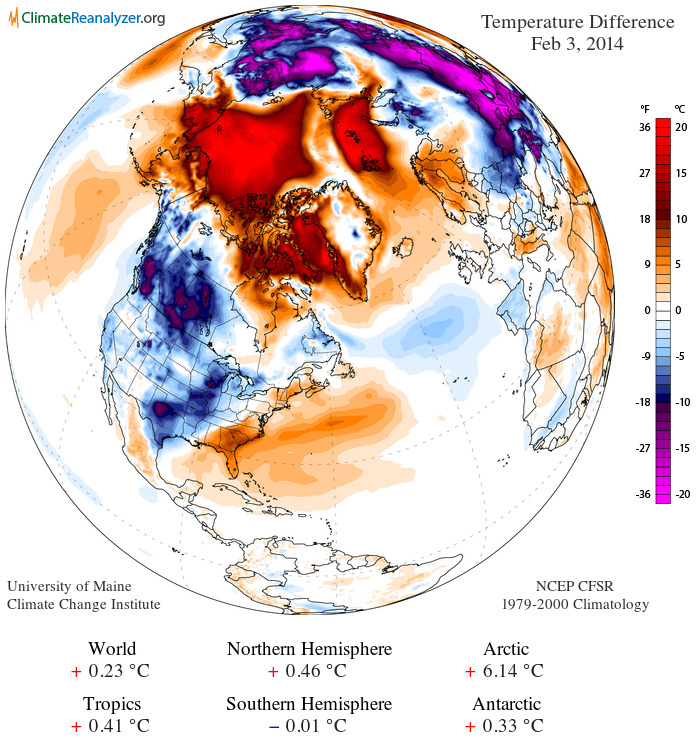
(Daily temperature anomaly from the Climate Change Institute. Data compiled from NASA and NOAA global monitors, satellite data and model analysis.)
Note the extraordinarily hot readings of +36 F over a large area of the Beaufort and Chukchi Seas coinciding with almost as extreme instances of warmth along the west coast of Greenland and throughout a region over Svalbard stretching on toward Arctic Russia.
Current temperatures in Svalbard mirror those in Gaithersburg, Maryland, thousands of miles to the south, with both sitting at 32 degrees F according to reports from Weather Underground. Svalbard is less than 600 miles from the North Pole and temperatures there are currently pushing the freezing mark, a level not typically breached in Svalbard until May.
Arctic sea ice near all-time lows
The exceptional Arctic heat has kept both sea ice extent and area near all time lows this winter with NSIDC showing extent and areas measures at their 3rd lowest for this date. Sea ice area anomaly is now 1.014 million square kilometers below the already low 1979 to 2008 mean, a significant negative deviation for winter.
As a result, some areas that are usually frozen solid by this time of year show little or no ice. The Bering Sea, for example, remains about 3/4ths open ocean. This is an extraordinary event as the Bering ice pack is usually approaching the Aleutians by this time of year. But, as we can see in the map below, huge patches of open water for this and other areas remain.

(Snow and ice extent for February 3, 2014. Note that the ice edge is far behind the 1979 to 2000 average limit line in all basins. Image source: Climate Change Institute.)
With the end of the freeze season about 30 days away, it would take a significant switch to cold to make up for the current ice lag. Meanwhile, Jet Stream models show the pace of heat influx to Arctic regions remaining high at least through the end of this week. Notably, a strong, warm-core high pressure system is predicted to develop in the region of the Bering Strait by Friday. This developing zone is projected to drive yet one more flood of warmth almost all the way to the North Pole:

(Jet Stream model predictions for Friday, February 7th show warm core high pressure system over extreme eastern Russia and Bering Strait. Image source: The University of Washington.)
In this pattern, the polar vortexes remain disassociated from the Arctic, with one being centered over Siberia and the other finding an almost permanent residence near Hudson Bay. It is also worth noting that this Jet Stream forecast also indicates a high likelihood of severe weather for the eastern US by February 7th as well.
Arctic heat likely to continue to shove cold air, instability extreme weather south
Though the polar vortex collapse related Arctic air invasion of the US last week has now mostly faded, as noted above, Jet Stream models indicate continued major Arctic air outflows from the much hotter than usual Arctic into Canada and the US. This continued instability sets the stage for a major battle between hot and cold air as regions southward warm up in anticipation of the advance of spring. The result is likely to bring numerous episodes of severe weather outbursts throughout the month of February. So we cannot rule out strong to extreme rain/snow events, thunderstorms, flooding and potential tornadoes as February progresses. As has been typical with the current Jet Stream pattern, the Central and Eastern US are most likely to be effected by these strong storm events. And, as we have seen with the increasingly severe climate-change driven extreme weather events of the past decade, the potential continues for record or near-record events.
Shifting west, a set of weaknesses in the high amplitude blocking pattern is likely to allow a stream of moisture to filter in over the parched western states. Unfortunately, this rain will probably arrive too little, too late to prevent major troubles for states like California come spring. In short, it would take a major inundation to alleviate drought conditions for the moisture-starved west. And a weakened, but still sputtering, blocking pattern isn’t likely to deliver the kind of moisture needed to end California’s 13 year drought. That said, any relief is likely a welcome change to those living through the worst conditions in at least 4 decades.
No Great Lakes freeze for 2014
In parting, I’ll leave you with a clear sign that, while the heat in the Arctic is plainly historic, the cold it drove into the US this winter was merely a noteworthy after-effect. The Great Lakes which, prior to the mid 20th Century, used to freeze solid almost every year, despite the recent cold snaps, remain ice free over a broad area.
The last year all the Great Lakes froze solid? 1979…

(Great Lakes with substantial portion still ice-free. Image source: Lance-Modis)
Links:
Arctic Heatwave Sets off Hottest Ever Winter Time Temperatures for Alaska


Colorado Bob
/ February 3, 2014Greenland’s fastest glacier reaches record speeds
“We are now seeing summer speeds more than 4 times what they were in the 1990s on a glacier which at that time was believed to be one of the fastest, if not the fastest, glacier in Greenland,” says Ian Joughin, a researcher at the Polar Science Center, University of Washington and lead-author of the study.
In the summer of 2012 the glacier reached a record speed of more than 17 kilometres per year, or over 46 metres per day. These flow rates are unprecedented: they appear to be the fastest ever recorded for any glacier or ice stream in Greenland or Antarctica, the researchers say.
http://www.sciencedaily.com/releases/2014/02/140203101016.htm
LikeLike
robertscribbler
/ February 3, 2014We must share a brain! I’m reading this one at the moment as well.
LikeLike
Colorado Bob
/ February 3, 2014That fiord is 1300 meters deep. at the calving front . And can melt back another 50 km. Pretty amazing. Talk about pulling the plug out of the bath tub.
LikeLike
robertscribbler
/ February 3, 20143 to 4 times acceleration is just extraordinary.
LikeLike
Colorado Bob
/ February 3, 2014Jakobshavn Glacier the World’s Fastest, Picking-up Speed
By Colorado Bob
Tue Jul 10, 2007 9:09 AM
In the story , they report that around the year 2000 the Jakobshavn started to pick-up speed. It went from the “normal” speed of around less than 1 foot a day to 113 feet a day in 5 years. This was widely reported then, so it’s a pretty good benchmark. The program aired in July of 2005, so this morning I went looking to see what the Jakobshavn was doing 2 years later………….So, it went from 113 feet a day in 2005 to 135 a day in 2007 ….. 22 feet a day faster.
In 2 years, the Jakobshavn Glacier has increased it’s speed by nearly 20%.
http://coloradobob1.newsvine.com/_news/2007/07/10/828271-jakobshavn-glacier-the-worlds-fastest-picking-up-speed
LikeLike
Colorado Bob
/ February 3, 2014The ubiquitous shallow icy lakes that dominate Alaska’s Arctic coastal plain have undergone a significant change in recent decades.
These lakes, many of which are no more than 3m deep, melt earlier in the season and retain open water conditions for much longer.
And 20 years of satellite radar also now show that far fewer will freeze right through to the bottom in winter.
The results of the space-borne survey are published in The Cryosphere.
What is happening to the lakes is an example of how land ice is following the pattern of diminishing sea ice in the region, say scientists.
http://www.bbc.co.uk/news/science-environment-26017431
LikeLike
Tom
/ February 3, 2014I’m sure you’ve seen this:
http://www.livescience.com/43045-arctic-warming-linked-stratified-air.html
Arctic’s ‘Layer Cake’ Atmosphere Blamed for Rapid Warming
The Arctic is leading a race with few winners, warming twice as fast as the rest of the Earth. Loss of snow and ice, which reflect the sun’s energy, is usually blamed for the Arctic temperature spike.
But a new study suggests the Arctic’s cap of cold, layered air plays a more important role in boosting polar warming than does its shrinking ice and snow cover. A layer of shallow, stagnant air acts like a lid, concentrating heat near the surface, researchers report today (Feb. 2) in the journal Nature Geoscience. [Images of Melt: Earth’s Vanishing Ice]
“In the Arctic, as the climate warms, most of the additional heat remains trapped in a shallow layer of the atmosphere close to the ground, not deeper than 1 or 2 kilometers [0.6 to 1.2 miles],” said Felix Pithan, a climate scientist at the Max Planck Institute for Meteorology in Germany and lead author of the new study.
LikeLike
robertscribbler
/ February 3, 2014Oh yes. The Arctic has lots of funny inversions that make its atmosphere and ocean a veritable heat trap under conditions of human warming. Thanks for this link. I’m trying for a comprehensive piece on how heat amplifies in the Arctic, get’s transported to the Arctic, and ends up stuck there. So this bit is very helpful.
LikeLike
susan2196
/ February 3, 2014Reblogged this on abraveheart1.
LikeLike
EveningStarNM
/ February 3, 2014Is it correct to say that the warmer temperatures in the Arctic are an “anomoly”, or is it more correct to say that we’re moving toward what will be the new “normal”?
LikeLike
robertscribbler
/ February 3, 2014There is no new normal. The new normal is anomaly.
LikeLike
EveningStarNM
/ February 3, 2014Well, it’s predictable that the arctic will be warmer, but I won’t quibble with the word.
LikeLike
robertscribbler
/ February 3, 2014OK, then. The new normal is heat anomaly. And, unfortunately, new normal is a bit cliche. Also, there’s nothing normal about the ‘new normal.’ The term implies a sense of comfort we don’t have.
LikeLike
xraymike79
/ February 5, 2014The term “new normal’ continues to be used quite a bit, implying that some new state will settle in and we can all comfortably adapt; however as Robert states, there is no new normal, but a constant state of accelerated change. How we will or won’t adapt can be answered in our present behavior — AGW denialism and corporate propaganda continue unabated, massive amounts of fossil fuels are still being consumed, and global GHG emissions showing no signs of decreasing. Are we adapting to the cues nature is giving us about our unsustainable activities?
LikeLike
John Christian Lønningdal
/ February 4, 2014Interestingly as Robert states, the Arctic sea ice extent is 1 million square km lower than the ALREADY LOW 1979-2000 average. I’d say anything in the past decades is a serious anomaly so comparing them to averages within these decades is not giving us the best picture of a healthy Arctic ice extent. Its probably 2 million square km lower than it had been if not for our added CO2 forcing.
LikeLike
Mark Archambault
/ February 3, 2014Robert, you wrote: “Oh yes. The Arctic has lots of funny inversions that make its atmosphere and ocean a veritable heat trap under conditions of human warming. Thanks for this link. I’m trying for a comprehensive piece on how heat amplifies in the Arctic, get’s transported to the Arctic, and ends up stuck there. So this bit is very helpful.”
I was just trying to remember the various reasons that the arctic is warming so much faster than the global average, and I came up short, so I think this article would be very useful.
I’m so glad I’ve come across your excellent website! This is one of the premier climate blogs in my opinion. Please keep up the great work of explaining the science to us ‘intelligent laypersons’.
LikeLike
robertscribbler
/ February 3, 2014I must admit I’ve got quite a passion for intelligent discourse. So it’s wonderful to be able to attract so many sharp minded folk and even moreso to be of help.
Best regards and thank you sir!
LikeLike
John Christian Lønningdal
/ February 4, 2014Robert has some very nice and up to date information about the state of the planet in a much more readable form, and noes not mask the seriousness of the issues. Robert also does a good job of linking in the history of events so you can get a bigger picture related to other incidents which are closely linked.
If you want even more information I’d recommend you to also pay these sites a visit:
– Climate Crocks (Peter Sinclairs Blog) – he also makes some great videos
– Skepticalscience – several levels of explaining the science
– RealClimate – very detailed and technical about recent research and papers
– Open Mind – Tamino’s blog which does great and detailed debunking of common myths
LikeLike
robertscribbler
/ February 4, 2014All top notch.
LikeLike
james cole
/ February 4, 2014I recently read that due to Iceland’s rapidly melting glaciers and ice packs piled on top of most major Icelandic volcanoes, that pressure of the ice is being released allowing a faster rise of the land over some dangerous volcanoes. There seems to be evidence that eruptions have increased in frequency in lock step with glacial ice mass loss on top of the volcanoes. Iceland’s glacial melt rivers are also at record highs, and expanding in size each year. Iceland has had a rapid melt the last 20 years with accelerated rates every melt year. The geology and physics of the volcanoes indicates that pressure of glaciers reduces eruptions, while melting appears to increase the frequency. One big volcano in particular, neighbor of the small one of 2010, is showing all signs of getting ready to blow. If Icelandic geologic science is right, the loss of ice will continue to increase eruption frequency out there in the Atlantic.
I think all of us are waiting ,with some fear, to see what the winter heat wave in the high arctic has in store for summer ice cover in the arctic sea and for jet stream behavior. One wonders what nature can do to top the last 12 months. Though I notice the professional denial community has not budged an inch and is hitting out with new media stories and blog posts. Chemtrails are back in the news and so is the infamous “15 year pause” in global temperature rise. I await the further denial stories that will be coming out to counter this coming year’s ice melt in the north.
LikeLike
robertscribbler
/ February 4, 2014I think it’s a plausible theory that needs further investigation. The melting ice and swelling oceans do change how pressure is distributed over the crust. I’ve seen one related study in which slope collapse and sea level rise were linked.
The deniers seem to be doing their best to make hay from the usual winter storms and cold snaps. But they appear to be having a very tough time with polar amplification. I really can’t believe the legs RE chemtrails. Condensation trails are a normal phenom as a result of jetwash heat and moisture condensation. Contrails…
LikeLike
Burgundy
/ February 4, 2014Volcanoes. Another potential negative feedback being triggered along with changes to the Gulf Stream. Icelandic volcanoes pose a severe threat to Europe as does the desalination of the North Atlantic. Both together would make Europe considerably colder. Although I’m not entirely sure whether that would be good or bad, depends upon timing I guess.
It would certainly increase fossil fuel use in Europe though. Too hot or too cold will generally increase energy consumption. Even negative feedbacks may be overridden as they trigger further positive feedbacks… so complicated. But if you throw in economic collapse and peak oil which will act in a similar way to negative feedback, perhaps we could come to a shuddering halt before we wipe ourselves out completely. Either way, not exactly something to look forward to.
LikeLike
robertscribbler
/ February 4, 2014Large volcanic eruptions are short term negative feedback (aerosol), long term positive (methane and CO2).
LikeLike
Burgundy
/ February 4, 20146.1 magnitude earthquake strikes Indonesia, plus they’ve raised the status to alert on 23 volcanoes. Something seems to be going on in Indonesia or at least underneath it.
LikeLike
Apocalypse4Real (@Apocalypse4Real)
/ February 4, 2014Hi Robert,
While we currently do have extreme anomalies in the Arctic, in the next week that erodes and a wave of Siberian cold blows over the NP and into the CAA, affecting the US all the way to the Mexican border. The warm anomaly drops to around +3 C, then the warmth begins to push back into the CAB.
See my post: http://a4rglobalmethanetracking.blogspot.com/2014/02/massive-siberian-cold-wave-to-blast.html
LikeLike
robertscribbler
/ February 4, 2014Good one A4R. That hot high over the Bering does pull a strand of. Old over the top, doesn’t it? At least in the GFS.
In any case, if this sets up, looks like we may have a situation similar to the one we saw in early January. Only more volatile.
The +3 C deviation is still strong. Just not where we are now.
LikeLike
coopgeek
/ February 4, 2014I’m alarmed by your warning of another warm storm hitting the Arctic this week. There’s been a little chatter over on Jeff Masters’ blog comments (which I read regularly despite the maddening signal/noise ratio) about a storm that just took down about 100,000 km2 out of the Bering and a similar amount near Greenland.
Data here: http://arctic.atmos.uiuc.edu/cryosphere/IMAGES/recent365.anom.region.2.html
I’m guessing that this new storm will be visible northbound on N. Pacific satellite maps, but do you know where it is right now? Feel free to ignore this question if it’s part of your big-picture piece on Arctic heat transfer coming up. Thanks!
LikeLike
robertscribbler
/ February 4, 2014This one’s a high pressure system, so the opposite of storm. But, yes, a lot of warmth stays in the region of the Bering and Chukchi even as a little cold slips over the top further north from Siberia. At least that’s what the models are showing.
LikeLike
robertscribbler
/ February 4, 2014This is a great link. Thanks for the head’s up, btw!
LikeLike
coopgeek
/ February 4, 2014You bet. And thanks for the correction on the high pressure system. I just re-read and that’s exactly what you wrote. So less visible on satellite but probably will show up nicely on that crazy interactive “earth” globe that’s all the buzz these days. I trust that you’ll tell us ALL about it as it unfolds. Thanks for your time on the watchtower!
LikeLike
robertscribbler
/ February 4, 2014I just wish there were some kind of way outta here 😉
LikeLike
Robert A. Vella
/ February 4, 2014Reblogged this on The Secular Jurist.
LikeLike
todaysguestis
/ February 4, 2014More on the Blizzards and floods in Europe.
BBC reports that 1/4 homes in Slovinia is without power:
http://www.bbc.co.uk/news/world-europe-26028321
LikeLike
robertscribbler
/ February 4, 2014Ouch. The Jet Stream is split into two or three powerful south north flows there. Odd weather that.
LikeLike
Burgundy
/ February 4, 2014Any idea what’s causing the split? I see the severe storms affecting the UK and coastal northern France, the heavy rain to the South and snow to the East. But here in the centre of France we’re seeing a warmish wet winter, generally catching the weak storm tail, nothing to extreme. I’m not complaining, but I’ve been wondering why. Blocking pattern of some kind or just that we’re under the jet stream, not too far North or South of it?
LikeLike
todaysguestis
/ February 5, 2014Some crazy photo’s of snow melt in Alaska
Alaska Just Suffered a Major, Avalanche-Filled Heat Wave
http://www.theatlanticcities.com/jobs-and-economy/2014/02/alaska-just-suffered-major-avalanche-filled-heat-wave/8296/
LikeLike
robertscribbler
/ February 5, 2014I am thinking they should credit my earlier article… 😉
LikeLike
todaysguestis
/ February 5, 2014UK storms wash away railway line and leave thousands without power
http://www.bbc.co.uk/news/uk-26042990
LikeLike