
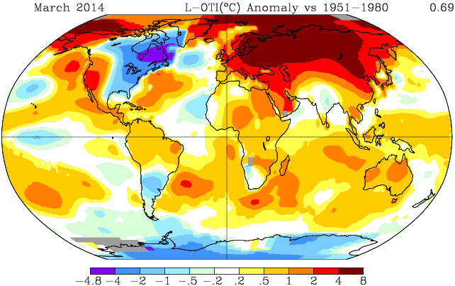
(NASA GISS Global Land-Ocean Temperature Anomaly vs the, already hotter than normal, 1951 to 1980 mean. Image source: NASA.)
According to NASA’s Global Land-Ocean Temperature Index, overall average temperatures for the month of March, 2014 were .69 to .7 degrees Celsius hotter than the 1951 to 1980 average. As a result, last month was the third hottest March in the global record since 1880. 2002 was ranked first hottest with 2010 as second hottest.
Nine of the ten hottest Marches on record have occurred since 2001. Ten of ten have occurred since 1998.
A wide zone of extraordinary temperature anomalies ranged throughout Siberia and the Arctic during the month with 4-8 C above average readings stretching along an enormous swath from Germany in the west to Yakutia in the east and from China in the south and on up to the North Pole.
Summer-like temperatures in Siberia
Large warmer than normal air pulses progressed from China northward over broad sections of Russia and Siberia throughout the month. These pulses harmonized with persistent high amplitude Jet Stream ridges over Eastern Europe to draw much warmer than average temperatures northward.
By early April, these conditions had translated into 70 degree (Fahrenheit) values for some sections of Siberia, where the annual fire season had an ominous, very early start for the Amur and the Baikal — Russian regions that are typically still locked in ice this time of year. Overall, by April 6, more than 2,000 hectacres of fires had been reported by the, justifiably, very concerned Russian officials.
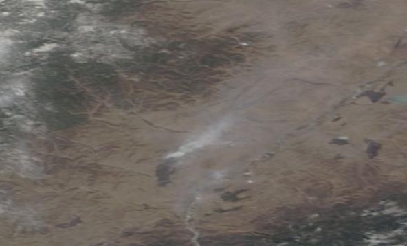
(An ominous and early start to fire season. Isolated Siberian wildfire visible from Satellite in center of frame on April 4, 2014. Image source: LANCE-MODIS.)
According to reports from Think Progress and The Siberian Times the heat coincided with extreme drought conditions:
“The forest fire situation is tense in Russia this year,” Russian Natural Resources Minister Sergei Donskoi said at a conference chaired by Prime Minister Dmitry Medvedev. “Due to a shortage of precipitation the forest fire season has begun almost one and a half months ahead of the norm.”
Temperatures in the Baikal and Amur regions were particularly hot with measures in late March and early April shattering previous temperature records by 2-9 degrees Celsius for the cities of Novosibirsk, Tomsk, Kemerovo, Barnaul and Gorno-Altaysk. Overall, this region of Russia has shown a very rapid pace of temperature increase: about .4 C per decade, or more than double the global average.
Polar amplification in very high gear
NASA zonal anomaly maps also continued to show evidence of an extreme polar temperature amplification in the Northern Hemisphere. Such high degrees of heat amplification at upper latitudes were a predicted result of human greenhouse gas emissions. Yet one more climate science prognostication that has borne out.
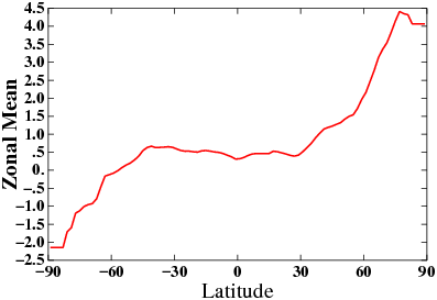
(March Zonal Temperature Anomalies. Image source: NASA.)
Links:
Siberia Experiencing Mid Summer Temperatures and Wildfires in April
Hat Tip to James Cole


Phil
/ April 12, 2014The 8 degree anomalies are very noticeable. Did they had to add an extra colour – cannot remember seeing that shade of red on those types of Figures before.
Do you know what are the typical upper bounds for anomalies in summer in the arctic are in overall terms as well as the distribution across the arctic? The latter is of interest because we have seem positive anomalies of 20 degrees C at certain locations this winter and I wonder of this also arises in summer.
If the anomalies are anythink like what was experienced for winter – 20 degree positive summer anomalies would be very dangerous.
LikeLike
robertscribbler
/ April 12, 2014Lately, we’ve had similar positive anomalies up to the Arctic Ocean shore during summer. Retreat of the Jet Stream during summer to the central Arctic has tended to keep a cooler air center there, so we haven’t yet had extraordinary high anomalies in the region just over the pole during summer.
As sea ice melts, we would expect this to change as the cold center shifts to Greenland water vapor content increases in the central Arctic and the ocean traps/radiates more heat.
LikeLike
robertscribbler
/ April 12, 2014As for color scheme, the dark red typically shows 4C+. The March heat pushing a +8C anomaly for this region is rather unusual. 2012 had a somewhat similar pattern, as did 2007. I’m not sure either was quite so hot.
Since about 2007, we’ve had pretty high heat anomalies for Siberia in spring time. March is a hit or miss.
LikeLike
mikkel
/ April 12, 2014Two things really bug me about how SST is reported based on plotting to min/max.
1) It makes it really hard to compare data over time because the scale is changing.
2) It makes it really hard to get an intuitive sense of anomalies because the scale is not even for +/-. It looks like the NE was almost as cold as the Arctic was warm until you see that the min is -4.8 and max is 8.
These criticisms have been going on for years but it never gets changed in the public data. In the data that the Navy uses they have set scales that are hard coded and generally that’s considered best practice.
LikeLike
robertscribbler
/ April 12, 2014I agree. The sliding and indefinite scales are confusing. That’s why it’s best to compare warming in aggregate in public data to a set start point — 1880.
It would worthwhile to strengthen the standards, as you suggest. And, yes, the navy measures do have a refreshing degree of clarity that seem to be, otherwise lacking.
As an aside, it’s even worse with sea ice… The start date we use, 1979, is well after melt began sometime in the 1920s.
LikeLike
mikkel
/ April 12, 2014Actually this NASA dataset seems to be standardized. It probably just needs to have more colors on the scale to incorporate the increasing strong warming.
LikeLike
robertscribbler
/ April 12, 2014It could use a + 1880 measure as well. NASA puts out good data sets, though.
LikeLike
james cole
/ April 12, 2014One question that I am wondering about is, will a fully developed El Nino event have any effect on the Arctic and Jet Stream patterns that could or would change these pulses of heat that Siberia, Northern Scandinavia, Alaska and Canada have seen lately? Having seen the great forests of Siberia, I can only shudder at the fire potential. I live in Northern Minnesota Boreal Forest, and since the 90’s we have had a major wide scale forest blow down event and 4 major fire events. The vast area I have canoed in since a child is now half destroyed in 15 years by heat, extreme wind events, drought and fire. It is amazing to canoe across dozens of lakes with moonscapes in all directions! Back in the 80’s climate science was predicting that the Minnesota Boreal forest would turn into Dakota’s style open plains and grassland due to climate change. I have lived to see proof that they are right, the forests are on the decline and the Moose are moving into Ontario seeking colder summers. At the present rate, the forests here will be gone in 40-50 years.
LikeLike
robertscribbler
/ April 12, 2014El Niño increases lower latitude heat and would result in a reintensification of the northern hemisphere jet.
That said, high amplitude waves continue to extend north over Alaska and into the Arctic as El Niño intensifies, perhaps becoming more exaggerated with increasing equatorial heat intensity.
Disruption of monsoonal flow and continental heating over Asia would also tend to intensify. So the warm pulses we are seeing there now may well be a harbinger as El Niño advances.
Ironically, what we’re seeing already is an arrival of an El Niño type Jet Stream pattern. So we could reasonably expect these trends to continue and to amplify should the very strong Pacific Ocean Kelvin Wave continue to emerge.
We’ve had quite a lot if blow-down here as well. Not enough to turn the land into moonscapes, though. Sounds quite stark and extreme where you are.
LikeLike
Mark from New England
/ April 13, 2014James, you wrote: “The vast area I have canoed in since a child is now half destroyed in 15 years by heat, extreme wind events, drought and fire. It is amazing to canoe across dozens of lakes with moonscapes in all directions!”
So sad and tragic. As someone who grew up lake fishing, I can only imagine how you must feel seeing this degradation of the landscape you love. I imagine fishing for bass, pike and muskies must be a fairly big part of the regional economy up there in northern MN. How has the sport fishing industry responded to this change, or do they seem oblivious? If THEY caught on with the connection to global warming, I imagine it would only help spur more serious reflection at the very least. I know the sport fishing industry was one of the first to push for action on acid rain in the 1970’s, as I recall magazines like ‘Field and Stream’ discussing it in a serious way back then.
LikeLike
james cole
/ April 14, 2014The general public up here seem oblivious. Though the major impacts have been up to the north on and near the Ontario border inside the Boundary Waters Federal Wilderness. We are on the rocky Canadian shield, the northernmost forests grow on very thin soil and the intense fires have burnt everything right down to underlying stone. Great White Pin and mixed forest has gone up in fires, a few bad droughts would compound this problem. A bit south of the Canadian borders here in NE Minnesota, the deeper soils have kept things stable. The BWCAW along the border and up into southern Ontario have seen the worst of it in the last 15 years. Some years back we had an epic fire storm that swept in a great circle with changing winds and destroyed the major areas I have canoed and wilderness camped in. It was a real shock to see the moonscape of underlying rock, reminds me of areas in Sweden where glaciers had stripped some coastal areas to bare stone and trees can’t grow.
LikeLike
robertscribbler
/ April 14, 2014The models show the southwest drought expanding right up the heart of North America. What I think the models probably miss is the impact on landscapes due to more intense storms and wildfires. The drought models do seem to capture the increased velocity of drying pretty well but I’m not certain they fully capture the erosive intensity of water/rain when it does come.
LikeLike
Colorado Bob
/ April 13, 2014Since January 1st Lubbock has received just 0.47” of precipitation versus a normal to-date (April 10) of 2.91”. More astonishing is the 32.91” total since October 1, 2010 (normal would be 63.81”). This is not only the driest 3 and a half-year period on record but surpasses the previous record for such by the amazing margin of 8.28”. The average annual precipitation for Lubbock (POR 1981-2010) is 19.12”…………Driest 42-month periods on record for Lubbock, Texas (since 1911). The previous driest such period (aside from this year) was that ending on April 30, 1955 when a total of 41.19” was measured versus the current 32.91”. Note that the great Dust Bowl drought of the 1930s ranks in third place with a 42-month total of 42.41” ending on April 30, 1936. Table from NWS-Lubbock.
Persistent Drought Still Reigns in Much of Texas
LikeLike
robertscribbler
/ April 14, 2014Thanks for this one. Excellent research here.
I find it extraordinary that Texans aren’t fighting tooth and nail to stop climate change. They might not realize it, but they’re in as dangerous a position as Bangladesh. Flood or a great drying. It’s all the same in the end. Renders lands uninhabitable.
LikeLike
Colorado Bob
/ April 13, 2014There Is A 99% Chance Climate Change Is Not Natural, Says Researcher Using Historical Data, Not Computer Models
http://www.ibtimes.com/there-99-chance-climate-change-not-natural-says-researcher-using-historical-data-not-1570996
LikeLike
robertscribbler
/ April 14, 2014Saw this report. I suppose some will continue to be surprised how clear and certain the science is becoming.
LikeLike
Mark in New England
/ April 14, 2014Encouraging that this is appearing in the “International Business Times”. Not so encouraging reading some of the comments.
LikeLike
robertscribbler
/ April 14, 2014Well, it’s good to see them not neglecting the news, whatever their KKK audience-base may think…
LikeLike
Colorado Bob
/ April 14, 2014For cities and farms across California, the latest numbers show this is shaping up to be a summer like none other.
Nearly one-quarter of the latest measurements (56 of the 233, to be exact) show a snowpack that is less than 10 percent of what it usually is this time of year. At least a dozen had no snow at all, even above 7,000 feet elevation. Averaging all the measurements statewide, the state is starting off the dry season with about 25 percent of the typical April 1 snowpack—which is where it started back in 1977, the year with the least snow ever measured in California.
http://www.slate.com/articles/technology/future_tense/2014/04/thirsty_west_california_s_meager_snowpack_will_exacerbate_a_dangerous_drought.html
LikeLike
Miep
/ April 14, 2014California will now procede to burn down like crazy until the El Niño arrives, at which point there will be plenty of bare ground for flooding. Meanwhile food prices will double. Yeah, gonna be a great year.
LikeLike
Colorado Bob
/ April 14, 2014And the infrastructure will be ripped a part , because the rain will be like hell coming to breakfast.
It’s not coming as a slow release. It’ll come like what we just saw on the Mississippi River .
The lowest river, the highest river.
When rain comes to California It will horrible. In ungodly amounts.
LikeLike
Miep
/ April 14, 2014I can remember hellacious storms back when I lived in L.A. in the nineties. Manhole covers jetting up in the air. Seven inches in one day. And that’s just the past. What’s 20 inches in one day going to do? When the levee breaks you got no place to go…
LikeLike
robertscribbler
/ April 14, 2014If the pattern sets up, we could see something like ten feet+ in one month.
LikeLike
robertscribbler
/ April 14, 2014The southwest is the US’s Bangladesh…
LikeLike
robertscribbler
/ April 14, 2014And the blocking high appears to be re-establishing itself after a month of letting a few strong storms through.
If that block remains as El Niño emerges, the drought will be terrific for the southwest this summer and the storms running up from the Pacific and into the Arctic could see major bombification.
Tracking atmospheric patterns and this does not look like a typical El Niño. More like a changeling kind of event that rhymes somewhat with past dispositions.
LikeLike
Colorado Bob
/ April 14, 2014As a tipping tip nears , the system moves to the extremes.
LikeLike
robertscribbler
/ April 14, 2014I’m seeing three high amplitude waves emerging during the transition to summer. One is a reinforcement of the 13 month long block running up through Alaska. Moving eastward, we see another large ridge emerging east of Svalbard. The third runs up where we exactly don’t need it — Yakutia and on up into the Laptev and East Siberian seas. Three wide open avenues for warm air to invade the Arctic plus an El Niño potentially emerging to pump the system full of a decade worth of stored Pacific Ocean heat content. Ocean warmth that is probably now more intense than at any time in at least tens of thousands of years.
LikeLike
Mark from New England
/ April 14, 2014And we have a ringside seat thanks to you, Robert, and also by looking outside our doors.
The IPCC (article in Boston Globe this morning) is saying we cannot afford another 10 years of inaction on GHG reductions, and perhaps this El Nino will spur that action.
LikeLike
robertscribbler
/ April 14, 2014IPCC is finally acting with due urgency. Those claiming the agency is becoming too alarmist are apparently blind to what is happening around the world on an almost daily basis.
LikeLike
Mark from New England
/ April 14, 2014Rich and Poor Nations Spar Ahead of Climate Report Release:
http://www.commondreams.org/headline/2014/04/13-0
At a time when we need national and international cooperation more than ever.
LikeLike
robertscribbler
/ April 14, 2014The longer we wait, the more difficult coordinated action becomes. Conflict over resources remains the underlying problem.
LikeLike
robertscribbler
/ April 14, 2014We need a global fund for rapid transition. Large economies should contribute the most. Small economies of poor and developing nations should benefit the most. This will result in the least conflict and instability. Punishing developed nations for past emissions is somewhat counter-productive. But we need to have wealthy nations accept responsibility and take leadership. I think there’s a way to craft this policy to make it both fair and nonpunitive, especially when contributing to transition is seen as a leadership role.
LikeLike
todaysguestis
/ April 14, 2014Chile fire in Valparaiso kills 12 and forces thousands to evacuate
http://www.bbc.co.uk/news/world-latin-america-27007884
Deadly fires in Chile kill 12, force 10,000 people to flee
http://rt.com/news/chile-valparaiso-fire-evacuation-208/
LikeLike
robertscribbler
/ April 14, 2014Thanks for this. Sad news…
LikeLike
Andy
/ April 14, 2014Watching “Years Of Living Dangerously” last night my wife and I both experienced a hard stop in that we immediately saw the causes and farming effect in Texas trailing those in Syria by a few years, but following a very similar track.
Lost rain with the expectation of rain, lack of rain turning to drought, drought turning to no crops / herds. This followed to by denial, desperation, resignation as the farmers deplete all savings, abandonment, move to the city broke.
I’m not implying that the outcome will be the same, but this may be played out all over the world.
LikeLike
Andy
/ April 14, 2014Global food inflation summary article from wsj.
Coffee up 70%, Pork up 42% and the list goes on….
http://online.wsj.com/news/articles/SB10001424052702303287804579445311778530606
The real ones to watch are corn (maize), rice, wheat, soy bean. When they spike, countries destabilize.
LikeLike
robertscribbler
/ April 14, 2014FAO index up to 213 at this point. Major movers are cereals and sugar.
LikeLike
robertscribbler
/ April 14, 2014At the very least, it’s mass migration from the US southwest.
Years of living dangerously is very well done and worth loads of acclaim. Hope the next episode doesn’t give fossil fuel interests a free pass.
LikeLike