More fuel for El Nino’s fire and a record hot 2015 on the way…
Last week, a set of climate models predicted the emergence of a large and moderately strong westerly wind burst running against the trades associated with an eastward propagating cloudy and rainy phase of the Madden-Julian Oscillation (MJO). And, over the past few days a moderate strength, but very wide-ranging, westerly wind pattern appeared.
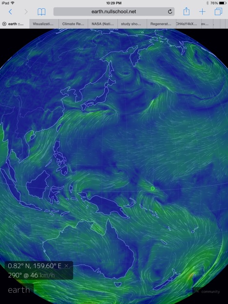
(A strengthening westerly wind burst over the Western Equatorial Pacific could produce a third warm Kelvin Wave and further heighten an El Nino that already has a potential to be very intense come Fall. Image source: Earth Nullschool.)
Today, 20 to 35 mile per hour westerly winds are prevalent along a 2,500 mile stretch of ocean running from just east of the Philippines, across an equatorial zone just north of New Guinea, and on eastward for hundreds more miles in the direction of the Date Line. The winds are associated with numerous low pressure systems developing both north and south of the Equator — their cyclonic wind patterns joining in a daisy chain like feature to drive a large synoptic westerly wind back-burst (WWB).
Over the next few days, winds within the zone are predicted to strengthen to near gale force intensity. But it’s the size of the zone that may have the greatest impact.
Strong, long-fetch westerlies in this region of the world have a tendency to push warm surface waters, now topping off at 31 degrees Celsius (and 1-2 C above the already hotter than normal 1979 to 2000 average), downward and eastward. This heat pump action generates what, in meteorological parlance, are known as warm Kelvin Waves. And warm Kelvin Waves are high energy fuel for strengthening El Ninos.
(Warm water propagation through the upper 300 meters of the central and eastern Equatorial Pacific serves as oceanic fuel for El Nino events. In the above graph by NOAA, not one but two warm Kelvin Waves are indicated — one peaking during April and May, and a second ongoing now. Will a significant westerly wind burst, now lighting off in the Western Pacific, generate a third warm Kelvin Wave by August? Image source: NOAA’s Climate Prediction Center.)
During mid-March, the Strongest Madden Julian Oscillation on record drove an extreme westerly wind burst (WWB) and produced a very strong Kelvin Wave. This Kelvin Wave ensured the progression to El Nino during 2015, an El Nino event that would have probably reached moderate strength by summer on the force of this single Kelvin Wave’s heating alone. An El Nino ensuring, when combined with the greenhouse gas heat forcing produced by humans, that 2015 would march into the record books as yet one more hottest year in the global climate record.
By early May, a second, albeit somewhat weaker, WWB generated another warm Kelvin Wave, heightening the potential for strong El Nino yet again. This time El Nino model forecasts picked up the doubled Kelvin Wave signal and began to produce some rather extreme predictions for El Nino come Fall. Late spring is an uncertain time for El Nino models due to an ocean tendency to cool down by September. So the impact of strong Kelvin Waves during spring can be somewhat muted. However, as June arrived, the model consensus for a strong El Nino emerging by Fall had solidified, if not along a range quite so extreme as some of the May numbers indicated.
Meanwhile, in the Central Pacific, anomalous warm sea surface temperatures were continuing to build. By mid-May, Central Pacific sea surface temperatures exceeded the moderate El Nino threshold of 1 C above average. By Monday, June 22, NOAA’s weekly El Nino statement had indicated that the Central Pacific region had warmed to a 1.4 degree Celsius positive anomaly. A level just 0.1 C short of strong El Nino intensity.
Adding a third significant Westerly Wind Burst on top of an already warming Equatorial Pacific throws yet one more variable into the dynamic El Nino forecast. A variable that could heighten the already strong potential for a major El Nino event late this Summer through to Fall. And one that could further heighten extreme global record hot temperatures during 2015. For the late June WWB is likely to produce an extraordinary third Warm Kelvin Wave, giving the currently strengthening El Nino yet one more shove toward increasingly extreme conditions.
Links:
NOAA’s Climate Prediction Center (Please support public, non-special interest based, science like the quality research and data provided to us daily by NOAA.)
NOAA’s weekly El Nino statement
Strongest Madden Julian Oscillation On Record


climatehawk1
/ June 25, 2015Tweet scheduled.
LikeLike
Loni
/ June 25, 2015Good post Robert, thank you for your tireless efforts.
So with the high temps in both atmosphere and ocean, these potential storm clouds could be reaching stratospheric heights this fall and winter eh? I lived on the North Coast of
California for the unforgettable ’64 deluge, so this summer I’m clearing around all of my culverts, making sure they’re clean and open. Batten down the hatches.
LikeLike
robertscribbler
/ June 25, 2015There’s a massive amount of rainfall and cloudiness over equatorial regions of the Pacific now. The moisture loading is getting very intense. If this trend holds, it looks like a very stormy fall/winter for the US West Coast. Given the ability of record warm atmospheres to hold record levels of moisture, there’s a decent potential that we could see unprecedented rainfall in the event that strong and strengthening El Nino conditions continue on through Fall. And, per the report above, the signals do keep pointing toward a stronger event.
LikeLike
dtlange
/ June 26, 2015Yes, and I think it will a real ‘crap shoot’ as to where, and how often, the moisture will fall on the West Coast.
LikeLike
Colorado Bob
/ June 25, 2015Remarkable before-and-after photos make it undeniably clear we’re ruining our planet
Read more: http://www.businessinsider.com/photos-show-how-climate-change-is-reshaping-earth-2015-5?op=1#ixzz3e6fuZD00
LikeLike
Paul_PNW_viaUK
/ June 25, 2015Man, reading those comments just makes me sad, “clearly photoshopped” “nothing to worry about” “perfectly natural” etc etc etc. Not that that’s in anyway different from the BS the FF industry has been peddling for ~50 years now I guess, I feel sick.
I am most definitely not looking to the shape of the world in 30-40 years time, in theory I’ll be 70+… [gulp]
Anyway, been reading you a few weeks Robert and I just wanna add my voice to the thanks for the time, thought and effort you put into this, it’s a great resource.
LikeLike
robertscribbler
/ June 26, 2015Stark contrast. And, yes, those comments are disconcerting (I moderate out a bunch of these on a daily basis so you guys don’t have to worry about them here). Looks to me like the pack from Heartland. In any case, they’ve ruined many forums that would otherwise be quite enlightened, forward looking, and problem solving oriented.
Also, I’m feeling a bit concerned about you, Bob, given your last comment. Please respond when you get the chance so we know you’re OK.
LikeLike
LAM78
/ June 25, 2015Hi!
This is my first comment, but Mr Scribbler, have you also seen that the Joint Typhoon Warning Center is showing two lows which later could be a repeat of the two cyclones we saw in March when the two tropical cyclones Bavi and Pam formed and helped to produce the strongest WWB on record? See: http://www.usno.navy.mil/NOOC/nmfc-ph/RSS/jtwc/ab/abpwsair.jpg
Tropical cyclones this time at year in the southern hemisphere should be very impressive indeed.
Cheers, LAM
LikeLike
robertscribbler
/ June 25, 2015Hello LAM, and welcome! Been keeping one eye on those models and they do look pretty amazingly impressive. My gut is that monster El Niño is rolling in. But I don’t want to over-reach too much. Will definitely keep tabs. Model agreement at this point is still pretty uncertain.
LikeLike
robertscribbler
/ June 26, 2015That WWB is looking healthier today. GFS 2-5 day shows solid event. Not as strong as March, but pretty substantial nonetheless.
LikeLike
Chowmin
/ June 28, 2015It is looking even healthier today!
LikeLike
JCH
/ June 26, 2015Slightly off topic – has anybody else noticed they dropped the red, El Nino typeset for ONI over recent reporting periods at the Climate Prediction Center?
http://www.cpc.ncep.noaa.gov/products/analysis_monitoring/ensostuff/ensoyears.shtml
LikeLike
robertscribbler
/ June 26, 2015The ONI numbers were adjusted downward. So El Niño won’t officially start until end June.
LikeLike
JCH
/ June 28, 2015That’s what I thought was up. I think we’re in for back-to-back El Nino events: 2015 followed by another one 2016-2017. Thanks.
LikeLike
WebHubTelescope
/ June 26, 2015We are getting closer to being able to predict El Ninos years in advance
https://forum.azimuthproject.org/discussion/comment/14731/#Comment_14731
LikeLike
Yvan Dutil
/ June 26, 2015The jump is behaviour is probably related to the «magic door» effect reported by many climatologists en 1978
LikeLike
JCH
/ June 28, 2015Right on.
LikeLike
robertscribbler
/ June 26, 2015Ramping changes to ocean forcing due to ghg emission throws a bit of a wrench in the works. So natural variability only studies will probably tend to have poorer resolution over time. Trenberth has done some excellent work in this regard and helped provide some clarity for timing RE the current El Niño.
LikeLike
WebHubTelescope
/ June 26, 2015Trenberth is good. What we have to watch out for is the pseudo-scientists such as Bob Tisdale over at the execrable WUWT blog. Ever seen how he operates with his phony-baloney narratives of ocean behavior? The guy is delusional.
LikeLike
robertscribbler
/ June 26, 2015Yes I have had the displeasure of encountering Bob. Last year, I warned that we could see a powerful El Niño due to the amazing amount of heat transfer into the Pacific through the mechanism of much stronger trades blowing over the equatorial zone. This emerging threat analysis was based on my reading of Trenberth and others. It was not intended as a blanket 100 percent certainty prediction, just to put a marker out on potential impacts. The report focused on strong WWB reported by WeatherUnderground and a related very strong warm Kelvin Wave being tracked by NOAA. Bob subsequently wrote a blog describing my, in his opinion, lack of knowledge RE El Niño. I find this rather odd due to the fact that my analysis was based on my current reading of the cutting edge science — which I then used to put out markers on potential threat issues. These primarily included:
1. Potential strong to very strong El Niño
2. Record atmospheric temperatures associated with a new El Niño
3. Potential extreme weather based on a combined analysis of known El Niño climatology coupled with known and potential impacts based on human heat forcing of the climate system (extreme weather, hydrological impacts, potential storm track impacts, heat transfer to the Arctic, etc).
Marker 2 clearly bore out. Marker 3 was a mixed bag with some expected impacts emerging and some surprises. Marker 1 is still up in the air but trends appear at least set for a moderate-strong event (with the ocean-atmosphere continuing to provide these Kelvin Wave kicks that up the risk to the strong side).
The point is that Bob basically used ad hominem as an attempt to discredit my work which is based on the work of people and agencies I consider to be giants in the field. So he’s basically attacking them through me as proxy. Not that they would make the same kinds of statements I do, nor would they sail as close to the wind on the issue of describing potential risks. But that’s a threat focus which I can explore. In essence, I can add a bit more speculation to the mix by doing prediction analysis that does not require a near 100 percent success rate. And the possibility that bad outcomes from human heat forcing can be predicted (even if all predicted events do not emerge with 100 percent accuracy) based on that science is what really makes Bob and Anthony’s heads spin.
So absolutely. Those guys have an agenda. And it’s to obfuscate the ability of science not only to ID human warming in the global climate system, but to sabotage the discussion of the outcomes of such warming. To prevent an understanding of weather and climate that takes into account the growing and increasingly dangerous human impact (ghg heat forcing).
It really is ugly and I’m preparing an article about their monkeying with the discourse for the Fall. So I guess you could say I wholeheartedly agree.
LikeLike
james cole
/ June 26, 2015In the early 1980’s researchers went north into Canada’s and Alaska’s far northern “first nations communities”, the tribes who have lived in the arctic from prehistory. One thing they found when questioning natives about climate and weather was the lack of names in their languages for things like “Thunder Storms”, and they had no names for a wide variety of “birds” that were appearing in the tundra. Older natives made clear to researchers that weather was already changing fast in the tundra. These old timers are gone now, but what would they think of these violent thunder storms triggers massive wild fires?
Siberian natives of the Russian tundra commented on the arrival of poisonous snakes above the arctic circle in the early 80’s, something they claimed never to have seen before.
LikeLike