
For Alaska and Canada, as of today, an unprecedented 12,000,000 acres of forest and tundra overlying the rapidly thawing and human greenhouse gas emissions warmed permafrost has burned — going up in vast, billowing clouds of smoke. This smoke has spread out, caught up in the meandering Jet Stream, and is now visible in far-flung locations by both ground and satellite observation.
In addition to painting skies across Canada, Alaska and the Western and Central US milky white, upper level smoke from the fires has crossed Greenland and the North Atlantic, entered the Central Arctic Ocean and is now visible as a hazy pall over web cameras observing North Pole melt.
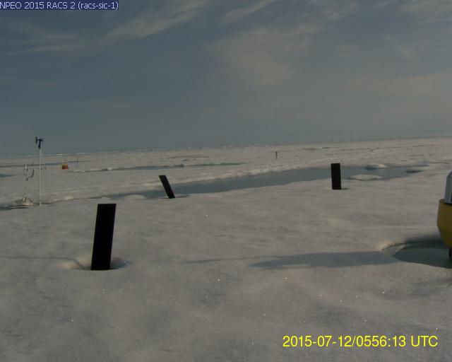
(Melt ponds and teetering markers near North Pole web cam beneath skies painted gray-brown by wildfire smoke. Image source: North Pole Environmental Observatory.)
In the above image we can see this smoke haze painting the sky a brown-gray pallor in the NEOPAWS North Pole web cam image. Beneath these skies, the sea ice surface has melted to the point that the marker strakes are wobbling off kilter and that substantial melt ponds are cutting deep furrows into the polar ice. The hazy hew of skies in this image together with an overhead cirrus cloud cover tinted brown indicates that smoke particles have been lofted into the Jet Stream level.
Wildfire Smoke over Sea Ice
Satellite tracking of the smoke also confirms ground-based observations. For as of July 6 a large bellow of smoke had wafted up from the unprecedented wildfires burning in Alaska (now at 4.44 million acres and climbing). Drawn up in a high amplitude Jet Stream wave this smoke could clearly be seen traversing the Beaufort and Chukchi Seas in the MODIS satellite shot:
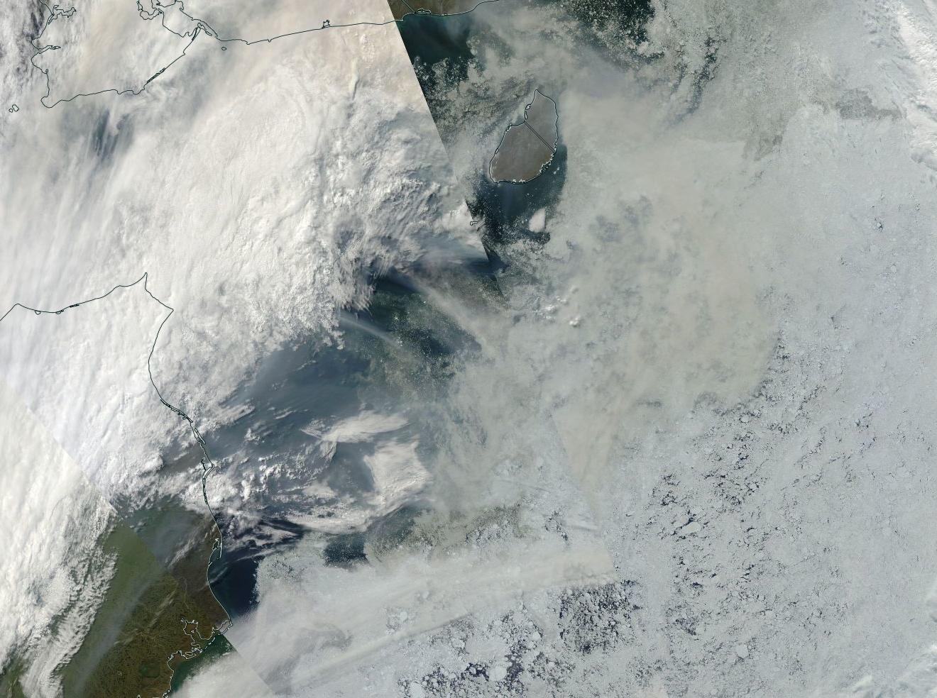
(Top and bottom frame images tracking a plume of wildfire smoke emitting from Alaska, crossing the Beaufort and Chukchi seas on July 7 and entering the Central Arctic on July 12. Image source: LANCE MODIS.)
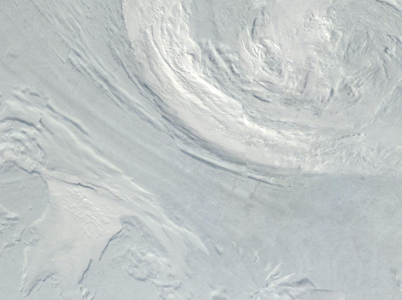
By Sunday, this smoke had become entrained in the draw between a cyclonic circulation over the Laptev Sea and an anticyclone formation on the Greenland side of the Arctic. It’s a dipole pattern that has now lasted for more than a week. One that is regarded as rather unhealthy for late season sea ice totals. Note the herring-bone formation of darkened upper level clouds drawn through the dipole and running diagonally from upper left frame to lower right of the second image. The pole in image 2 is also in the lower right frame.
Conditions in Context — Brown Carbon at Jet Stream Level is an Amplifying Feedback
Lofting large amounts of brown carbon into the Jet Stream level of the atmosphere is an amplifying feedback to human-caused warming. One occurring in addition to the added rate of carbon release generated by these wildfires as well as to a transient negative feedback coming from generating thick, low level clouds, that block out sunlight.
High level clouds alone aid in the heating of the Earth — allowing visible sunlight to penetrate while trapping long rave radiation rebounding from the Earth’s surface. Painting these clouds dark through brown carbon smoke particulate emission into the upper atmosphere provides an added heat kick by further lowering cloud albedo and by re-radiating an overall greater portion of the transient heat. As a final insult, the brown carbon aloft eventually precipitates down to the surface. When such precipitation lands on ice sheets and northern hemisphere snow cover, it darkens the snow and enhances melt. A kind of ominous global warming fallout.
Smokey haze over North Pole melt ponds — one albedo reducing process being reinforced by the other.
Links:
North Pole Environmental Observatory
Alaska Interagency Coordination Center
Canada Interagency Wildfire Center
Hat Tip to Colorado Bob
(Please support non special interest based, publicly funded science, climate change mitigation, renewable energy transition, and climate change resiliency efforts)


Colorado Bob
/ July 13, 2015Terra/MODIS
2015/193
07/12/2015
22:10 UTC
Fires and smoke in northern Alaska
LikeLike
Colorado Bob
/ July 13, 2015Have a look at today’s shot of Northwest Greenland , and Ellesmere Island –
Terra/MODIS
2015/194
07/13/2015
01:15 UTC
LikeLike
caerbannog666 (@caerbannog666)
/ July 13, 2015A document summarizing the Alaska wildfire status can be viewed here: http://t.co/8ONal0BpY3
The document is updated daily. Here are summary stats for today’s (7/13) update:
Total acres: 4,447,182.30
Burn acreage running >14 days ahead of 2004 (worst year on record).
Looking seriously ugly!
LikeLike
robertscribbler
/ July 13, 2015Yes, we’ve been tracking this since jump and even predicted a high risk of extreme fire outbreak back during mid June.
LikeLike
robertscribbler
/ July 13, 2015Please see: https://robertscribbler.wordpress.com/2015/06/22/worst-fire-conditions-on-record-as-heatwaves-drought-bake-north-american-west-wildfires-erupt-from-california-to-alaska/
And you’re right. Two weeks ahead of schedule is seriously ugly. A big jump from last week’s one week ahead of schedule numbers and showing multiple days when wildfires hit 300 K or more acres burned in July.
LikeLike
climatehawk1
/ July 13, 2015Tweet scheduled.
LikeLike
Colorado Bob
/ July 13, 2015Eric Blake (National Hurricane Center) and Phil Klotzbach (Colorado State University) called attention this weekend to some remarkable statistics. Since Thursday, we’ve seen three tropical storms develop in the central Pacific, all of which broke early-bird records in the period of reliable data that extends back to 1949:
Earliest tropical storm during hurricane season: Ela (July 9).
Previous record: Wali, July 17, 2014
2nd earliest tropical storm during hurricane season: Halola (July 11).
Previous record: Maka, Aug. 11, 2009
3rd earliest tropical storm during hurricane season: Iune (July 11).
Previous record: Moke, Sep. 4, 1984
http://www.wunderground.com/blog/JeffMasters/comment.html?entrynum=3041&page=1#commenttop
LikeLike
robertscribbler
/ July 13, 2015We’re at new thresholds yet again.
LikeLike
Nuwan
/ July 13, 2015What about the aforementioned arctic hear dome. High pressure system. Area and extent fall somewhat fast it seems. What will happen in this melt season?
LikeLike
robertscribbler
/ July 13, 2015We’ve had some strong losses this past week. The dome has now settled into dipole which is also melt promoting. Chukchi, ESS, Laptev at highest risk for rapid melt. The near Greenland to pole also taking a hit from warm atmosphere. Weather tendency is still for export. But the gyres this year won’t be as strong as in a 2016 and 2017.
LikeLike
robertscribbler
/ July 13, 2015Somewhat related, global methane mean in the 475 mb height hit 1836 on Saturday. That’s a 35 ppb departure from last year. Pretty significant.
LikeLike
Colorado Bob
/ July 13, 2015More Rain Events Speed Melt on Greenland Ice Sheet
July 13, 2015
with Peter Sinclair
New paper in Nature Geoscience, Jason Box and Alun Hubbard are co-authors.
Above, I got a quick rundown from Dr. Box, a few days ago, via (sorry) herky-jerky skype from Northern Iceland.
While on the ice for Dark Snow 2014, we experienced a 30 hour precip event that featured high wind and horizontal driving rain. Afterward, ablation stakes on-site indicated that a very large amount of surface melting had taken place during the previous day and a half.
The new study finds that increased incidences of rain on the Greenland sheet may indeed be a contributing factor to more mass loss, by sending large volumes of warm water deep into the ice, now and even more so as the arctic continues to warm.
http://climatecrocks.com/2015/07/13/more-rain-events-speed-melt-on-greenland-ice-sheet/
LikeLike
Colorado Bob
/ July 13, 2015LikeLike
Colorado Bob
/ July 13, 2015What Box says about warm rain also applies to altitude as well –
The Hindu Kush Before and After the Great Pakistani Floods
I saw this image from the Swat Valley in August, and I was stunned . Not for what is in the foreground, I was in the Big Thompson Flood in 1976. I know what happens when it rains like hell in the mountains. What struck me are those mountains in the background. That is the Hindu Kush . These two pictures were shot in the last week of July (left), and from the same spot 3 weeks later. Look at all that missing snow.
Link
LikeLike
robertscribbler
/ July 13, 2015Another person I think we deserve a hat tip from. We were writing about warm rain over glaciers two years ago.
Good work by Box and Peter, though.
LikeLike
Colorado Bob
/ July 13, 2015Nares Strait ice on the move
The fast ice in Nares Strait is finally giving way, relatively late again compared to recent years, after staying open over winter for a relatively long time as well. In the period the ice arch finally formed, it even got pushed back and forth a bit, probably making it stronger. But now it’s failing, enabling multi-year ice floes to be transported from the Central Arctic Basin to Baffin Bay.
Commenter oren posted the following animation of LANCE-MODIS satellite images on the Arctic Sea Ice Forum to show how the arch has been breaking up in the last couple of days, which is always impressive and fun to watch:
Link
LikeLike
robertscribbler
/ July 13, 2015I knew you’d catch this one, Bob. That high is backing ice out through the Nares even as its aiding transport toward the Fram. Good eye, my friend. Damn good eye.
LikeLike
Phil
/ July 13, 2015Great post Robert. Commentary on Arctic Sea Ice Forum seems to indicate continued favourable melt conditions for the next week or so.
Does the black carbon affect insolation rates by acting like a type of cloud? I know it reduces Albedo by darkening any surface it settles on such as seen in some of Dr Boxes pictures of Greenland. Not sure if it has the same impact on remaining sea ice.
LikeLike
robertscribbler
/ July 13, 2015The black/brown carbon aerosol becomes embedded in cloud structures in the event that it doesn’t act as a cloud suppressant. If it suppresses clouds, then we have more sunlight on ice. If it becomes embedded in thin clouds, especially upper level cirrus, then the cloud albedo goes down and radiative trapping enhances. Only when the small particulate density is very high and energetically involved in cloud formation does aerosol brightening occur and this is usually only in stratus and cumulonimbus clouds. So the brown carbon has a net positive radiative forcing unless it is active at lower level denser clouds or in thunderstorms.
LikeLike
Phil
/ July 13, 2015Thanks for the clarification.
LikeLike
John
/ July 13, 2015Reblogged this on jpratt27.
LikeLike
Phil
/ July 13, 2015I had a quick look at earth null school. Any chance of the large cyclone off of China impacting the Arctic via Bering Straight. I seem to recall a previous cyclone sort of bounced off of the Philippines and then travelled north eventually affecting the Arctic via the Bering Straight.
LikeLike
robertscribbler
/ July 13, 2015It’s possible, Phil. Seven days out looks like a pretty deep low running smack into the block as it enters the Bering. If the ridge is strong enough, it could inject that storm directly into the ESS, Chukchi or Beaufort. T deltas could pump that storm up if it enters the Arctic.
So good catch and thank you. I’ll be monitoring and hat tipping you if this ends up coming about. But it’s still a long way out.
LikeLike