
Fossil fuel burning is really ramping up the global heat. And for the typically cold Arctic Ocean coastal region, this means that temperatures are now able to strike into the 80s during mid-May.
Today, a very extreme wave in the Jet Stream produced an elongated ridge pattern that ran far to the north over Eastern Europe. This high amplitude wave brought with it temperatures that ranged up to 20 degrees Celsius (36 degrees Fahrenheit) above normal for this time of year. A heat surge which pushed temperatures to 29 C or 84.2 F near Archangel, Russia.
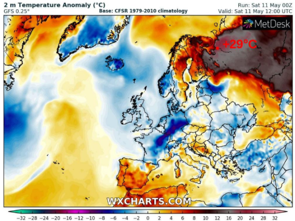
(Severe heat strikes northeastern Europe as part of an extreme jet stream wave pattern. Image source: WX Charts. Hat tip to Peter Sinclair.)
The kind of jet stream wave that spurred this extreme heat has become common over recent years. It’s an atmospheric feature that some scientists have associated with polar amplification — an aspect of human-forced climate change in which the poles warm faster than the lower latitudes.
During 2019, heat transfer into the Arctic has contributed to near record low and record low sea ice extent values in the months of March, April and May. The wavy jet stream patterns have also been associated with a number of severe weather events. Today’s extreme northern heatwave fits into a longer-term pattern of similar occurrences.
(Analysis of recent extreme jet stream pattern over Eastern Europe.)
Wavy, persistent jet streams have recently been associated with worsening weather — heat waves and wild fires in the ridge zones and severe precipitation in the trough zones. Scientists like Dr. Michael E. Mann and Dr. Jennifer Francis have warned that the associated Jet Stream waves are linked to human-forced climate change and are likely contributors to recent events.
The extreme weather we’re seeing around the Northern Hemisphere, such as heat waves, floods, droughts, and wildfires, is related to an unusual, undulating pattern in the jet stream. The other part of this that’s atypical is that this undulating pattern doesn’t usually hold longer than a few days. But this one isn’t going anywhere. Our work shows that this sort of pattern, which has been associated with many of the most extreme, persistent weather events in recent years, including the 2003 European heatwave, the 2010 Moscow wildfires, the 2011 Texas and Oklahoma drought, and the 2016 Alberta wildfires to name a few, is becoming more common because of human-caused climate change, and in particular, because of amplified Arctic warming.
It looks like 2019 is no exception to the longer-term trend. And we have already seen a number of instances of middle latitude extreme weather contributed to by the jet stream features Dr. Mann mentions above this year.
(Want to help fight climate change by switching to an electric vehicle? Get 5,000 free supercharger miles through this link.)


