Winter is Supposedly Coming; So Why is California Burning?

As forecasters expect a warming climate will make Santa Ana winds more frequent and faster, that Santa Ana blowtorch is likely to do a lot more damage to the developed parts of the state. — One of the conclusions of a recent climate study.

You can only imagine the impact this weather is having. — Los Angeles Fire Chief.

*****

The popular refrain these days is that ‘winter is coming.’ But for California and the North American West, this is clearly not the case.

(Four large wildfires burn across Los Angeles in this December 5 satellite shot. Image source: NASA Worldview.)

Conditions across the West have been drier lately. Hotter lately. A lot less winter-like during the winter season lately. Add in the fact that climate change is expected to increase the strength of the wildfire-sparking Santa Ana winds and this trend of ebbing winter is a rather serious factor.

The very reason why we use the words — fire season — is due to the fact that fire is more prevalent when it is hotter, when it is drier, and when the dry winds blow more strongly. For California, fire season happens twice a year — once in early summer and again in autumn as the dry Santa Ana winds begin to howl.

(Consistent unseasonal heat and the development of powerful high pressure ridges over the North American West amplify the Santa Ana winds and set the stage for more severe wildfires. This week, a strong ridge and related abnormal warmth and drought helped to fan a historic Los Angeles outbreak. Image source: Climate Reanalyzer.)

The Santa Ana season lasts from October through April. It notable due to the fact that it tends to threaten more heavily populated areas. Its primary mitigating factor — cooler winter weather — is receding. And, according to this research, the same factors that are warming the U.S. West are also making the Santa Ana winds blow stronger. So we have good reason to believe that the effects of human-caused climate change are making California’s fall and winter fire season considerably worse.

Today is December 6, just a little more than two weeks before the Winter Solstice. Seasonally, we are at the gates of winter. Winter should be coming. But, instead, we have drought in Southern California. Instead we have had consistently warmer than normal weather over the past 30 days. Instead we have 70 mile per hour Santa Ana winds raging over withering peaks and through the drying valleys. These are conditions consistent with a fire season amplified by climate change. Not with normal winter.

And today, in Los Angeles alone, we have four fires raging simultaneously.

https://twitter.com/joepezz11/status/938449494223605760

The largest fire, the Ventura Fire, has now burned more than 65,000 acres. It threatens 12,000 buildings. And it is already estimated to have consumed at least 150 of these structures. The fire has cut off power to upwards of 250,000 people and has forced numerous closures and evacuations.

The Creek Fire, Rye Fire, and Skirball Fire have reportedly burned an additional 15,000 acres and forced more than 150,000 people to evacuate. The Skirball fire is threatening the Getty Museum even as it has forced the closure of a section of highway 405. This 150 acre fire is also encroaching upon a 28 million dollar home owned by right wing media mogul — Rupert Murdoch. Notably, Rupert has used his media empire to support the views of climate change deniers and has called rational concern over climate change related risks ‘nonsense.’ Today, one of his many homes may burn as a result of such ‘nonsense.’

(Present location and extent of Los Angeles wildfires. Image source: Google Maps.)

In total, more than 1,000 firefighters are presently battling these four fires around the Los Angeles region. And the risks to the city are now as high as they have ever been. For on Wednesday, weather forecasters are calling for Santa Ana winds to continue to gust as high as 70 miles per hour. With the strength of these powerful fire-inducing winds peaking on Thursday as gusts are predicted to hit as high as 80 miles per hour. The winds will loft sparks and burning material from the fires and drop it over the city — creating nightmare conditions for firefighters trying to contain the four blazes. Red flag warnings — indicating that conditions are ideal for fire combustion — are expected to remain in place over Southern California through Friday.

Massive Wildfires Burn From California to the Arctic Ocean as Temperature Records Shatter

Record heavy precipitation and cooler conditions across Western North America earlier this year have again given way to record warmth as a strong high pressure ridge and associated extreme Pacific and Arctic Ocean surface temperatures have ushered in blazing heat and multiplying wildfires.

In California, massive wildfires have forced nearly 5,000 people to evacuate. In British Columbia, 14,000 have fled as more than 1,000 firefighters battle numerous large blazes. And along coastal Alaska and Canada’s Northwest Territory, large wildfires are burning near the shores of an, until recently frozen, Arctic Ocean.

(Large wildfires spill plumes of smoke over major sections of North America on July 11, 2017. Image source: NASA Worldview.)

In the U.S., the Whittier fire, which forced mandatory evacuations in southern California, is now 48 percent contained after having burned 12,000 acres. In the north of the state, near Oroville, the Alamo fire is 65 percent contained at 28,000 acres and evacuation orders have been lifted.

As large fires continue to burn across the west, the U.S. Interagency Fire Center now has a stated national preparedness level of 4 out of 5 — or the second highest alert rating. So far 2017 has seen 3,593,000 acres burned in the U.S. — which is above the 10 year average. An average that has already been pushed higher due to human-forced warming and an overall lengthening of the fire season.

Further north, British Columbia is suffering a rash of severe fires as extreme heat and high winds are blasting away at vegetation that vigorously regrew when drought conditions retreated earlier this year. Now, 215 active fires are reported as the province mobilizes national military forces and considers making calls for international aid. Presently, 21 large fires are causing considerable havoc throughout BC. Fire officials remain on heightened alert as strong winds, heat, and lightning threaten to make a bad fire situation even worse over the coming days.

Still further north and extending all the way to the shores of the Arctic Ocean, satellite photographs provided by NASA show large wildfires burning through typically frozen regions of Canada’s Northwest Territory and in northern Alaska. Many of these fires are quite vigorous — producing large smoke plumes that have blanked much of the region.

(Fires burning near the Arctic Ocean on July 10, 2017. For reference, bottom edge of frame is 280 miles. Image source: NASA Worldview.)

Such widespread burning over such a large region of North America — extending from California to the Arctic Ocean — has been spurred primarily by record heat building beneath a massive high pressure ridge. In the far North, temperatures approached 90 degrees Fahrenheit just south of the Mackenzie Delta near the Arctic Ocean earlier this week. Over typically cool British Columbia, temperatures have consistently ranged in the 80s and 90s and are expected to continue to hit near the 90 degree mark this week. And in the U.S. Southwest, numerous temperature records were broken over recent days as readings rocketed into the 100s and 110s.

Both the heat and these massive fires have likely been made worse by human caused climate change. Overall, global temperatures have recently hit around 1.2 C above 1880s averages. As a result, over 80 percent of the globe, heatwaves are both more severe and more likely to occur. Meanwhile, due to climate change related factors, the western wildfire season in the U.S. is now 105 days longer than it was in 1970 — just 47 years ago. Arctic sea ice retreat in recent years has likely accompanied further warming of the far northern land masses which have also seen increasingly severe wildfires over permafrost zones.

Links:

Wildfires in Canada, California Force Thousands to Evacuate

BC Wildfire Status — All Eyes on the Weather

Canadian Interagency Fire Center

National Interagency Fire Center

NASA Worldview

Earth Nullschool

Climate Change is Tipping Scales Toward More Wildfires

Unprecedented Climate Extremes

Unprecedented Wildfires Over Canada and Siberia

Featured Comments:


La Nina Fizzles, Pacific Hot Blob Returns, Record Global Heat Likely to Remain

A change of three degrees [Celsius] is an “extraordinary deviation — something you would expect to happen once in a millennium.” — Richard Dewey, www.SkepticalScience.com, on ocean warming in the northeastern Pacific

*****

Four degrees Celsius. That’s the current deviation from the 1981 to 2010 average for sea-surface temperatures over a broad region of the northeastern Pacific, a deviation you typically wouldn’t see once in a thousand years.

During 2013 to 2015 a similar warm-up over this same region of water occurred. Such extreme heat at the ocean surface generated mass loss of sea life. Numerous species from plankton to krill to copepods to starfish and many more on up the food chain were impacted. This great ocean warming also sparked losses of ocean oxygen off Oregon and Washington, pushing waters there into low-oxygen and anoxic states. These states, though they do not support advanced ocean life, tend to support anaerobic microbes that produce various toxins (including hydrogen sulfide gas). At the same time, atmospheric circulation was also impacted, resulting in unprecedented drought conditions for California as a ridiculously resilient ridge of high pressure settled in.

noaa-sea-surface-temperatue-anomaly

(Region of the northeastern Pacific about the size of the state of Washington shows ridiculously hot sea-surface temperatures in the range of 4 C above average. Such once-in-a-thousand-years ocean-surface heat has now occurred for three out of the past five years. As end 2016 nears, this unprecedented blob of hot ocean-surface waters appears to be returning. Image source: NOAA ESRL.)

Such a terrible blow to ocean health combined with ever-more-extreme atmospheric conditions are the very hallmarks of a heating climate. As a result, the events associated with the 2013-2015 hot blob will likely, in future years, be seen as one of the warning shots across North America’s bow — an indication that climate change-related impacts were about to seriously worsen.

Hot Blob Re-Forms as La Nina Splutters

Now, after a one-year hiatus, the hot blob is back and northeastern Pacific sea-surface temperatures are again on the rise. A previously-predicted La Nina is abruptly spluttering out, apparently crushed by a periodic warming of the northeastern Pacific called the Pacific Decadal Oscillation (PDO). This natural variability-related feature is combining with climate change-induced ocean warming to again push ocean surface temperatures into unprecedented ranges.

heat-fire-risk-california

(The northeastern Pacific hot blob is a climate change-related feature that contributes to record heat, drought and wildfire risk for California. Over the coming week, the re-formed hot blob appears ready to plunge the state into 90 to 1oo degree (F) conditions — which will intensify wildfire risk for the state. Image source: Pivotal Weather.)

With the PDO again firing up, the hot blob re-forming, and La Nina starting to splutter, we can expect global temperatures to remain closer to the record-hot levels achieved during 2015 and 2016. This is bad news in that 2017 through 2022 might see another record-hot year coordinate with El Nino, which would push even closer to 1.5 C and 2 C climate thresholds — a clear sign that the age of fossil fuel exploration and burning needs to end as swiftly as possible if livable climate conditions are to be maintained.

Nearer-term, if this heat in the northeastern Pacific remains in place, we can expect worsening hot and dry conditions for the U.S. west coast even as sea life in the affected region again falls under threat. With global temperatures now hitting a range of 1.2 C or more above 1880s averages, there is risk that this event could match or even exceed the related harmful impacts seen during the 2013 to 2015 timeframe.

high-amplitude-jet-stream-waves-rrr

(Unusual high-amplitude Jet Stream ridging over the U.S. west coast like that predicted for Sunday in the GFS model run is associated with both extreme sea-surface temperatures in the northeastern Pacific [the hot blob] and sea-ice loss in the Arctic, both caused by global warming due to fossil-fuel burning. Note the numerous additional powerful ridge and trough formations running downstream of this unusual Jet Stream feature. Image source: Earth Nullschool.)

Climate Change Links Again Non-reported by Media

Despite an obvious relationship between global warming and extreme regional heating events like the hot blob, some prominent media sources continue to link the formation of the hot blob to natural variability without mention of climate change. To do so fails to tell the whole story. Without that 1.2 C warming of the Earth since the 1880s due to our rampant burning of fossil fuels, we would not be seeing so much heat piling up in the northeastern Pacific. As such, the PDO has been put into a kind of climate change hyperdrive. And that’s what’s creating conditions under which these big, dangerous ocean hot blobs continue to grow.

Links:

Skeptical Science

Ridiculously Resilient Ridge

NOAA ESRL

NOAA ENSO

Pivotal Weather

Earth Nullschool

The Weather Channel

Hat tip to DT Lange

Hat tip to Greg

Hat tip to Colorado Bob

Climate Change, Drought Fan Massive Sand Fire, Forcing 20,000 Californians to Flee

On Friday, amidst temperatures exceeding 100 degrees Fahrenheit, and at a time when California is now entering its fifth year of drought in a decade when seven out of the last ten years have been drought years, a rapidly growing and dangerous wildfire erupted in the hills north of Los Angeles.

(Sand Fire looms over Santa Clarita, California. Video source: Sand Fire Time Lapse.)

The Sand Fire, which some firefighters are calling practically unprecedented, sparked before typical wildfire season peak and began a rapid spread that consumed 10,000 acres per day from Friday through early Monday. Nearly 3,000 firefighters scrambled to gain a foothold against the blaze, but were somewhat unprepared as contracted water-bomb aircraft from Canada won’t be available until next month, during what is usually the worst part of fire season. The aircraft assistance was planned as extra fire-suppression capability for Santa Clarita, but typical fire threat and risk assessments no longer hold much water in an era where human-forced climate change is pushing temperatures and drought conditions to new extremes across California.

By Monday, the fire had exploded to 33,000 acres (51 square miles). In total, 18 buildings are now reported to have burned and more than 10,000 others have been evacuated. A population the size of a small city, 20,000 people, have now been displaced by this rapidly expanding wildfire. Due to heroic efforts by firefighters, an estimated 2,000 homes have been saved so far. Sadly, the fire has also now claimed a life.

California Wildfires July 24

(Smoke plumes from large wildfires burning over southern and western California, framed by a warming Pacific Ocean, a drying Central Valley, and what appear to be snow-free and bone-dry Sierra Nevada Mountains in this July 24 LANCE MODIS satellite shot.)

Continued hot temperatures and 30-mile-per-hour winds are expected to continue to fan the fire today, which as of this writing is just 10 percent contained. If the worst case is realized and this fire continues to expand out of control, as many as 45,000 homes may ultimately be forced to evacuate. Such an evacuation would be comparable in scale to the Fort McMurray Fire which raged through Alberta during May and forced more than 90,000 people to flee.

Conditions in Context — Living in a Fire Age

There is widespread geological evidence of voracious fires burning through large regions of the globe during past hothouse warming events. At the Paleocene-Eocene boundary 56 million years ago, a warming rate that was about ten times slower than what we are experiencing now set off immense blazes that ripped through the world’s peatlands and forests. In other words, evidence points to past instances of Earth warming into hothouse conditions generating periods of intense fires that may well be called fire ages. Today, the Earth is about 1.2 degrees Celsius warmer than during the late 19th century. This high temperature departure combines with a very rapid rate of continued warming to dramatically increase wildfire risks around the globe.

Drought Climate Change

(Conditions related to climate change continue to increase drought frequency across the U.S. West. For the past five years, California has seen the brunt of this predicted increasing drought trend as a result of human-forced warming. Image source: US Drought Monitor.)

More local to the Sand Fire, California is in a zone that global climate models have long predicted would suffer from severe heat and drought as a result of fossil-fuel burning and related human-forced warming. This year’s persistent above-average temperatures on the back of five years of drought have greatly increased wildfire risk for the state. Millions of trees now stand dead, surrounded by withered vegetation in a heating and drying land — a vast range of additional fuel that is ever more vulnerable to ignition.

Not only do these conditions generate a higher risk of extreme fires during fire season — sparking blazes like June’s Erskine Fire which burned 200 homes and was the most destructive fire in this California county’s history — but they also increasingly spark large wildfires out of season. It’s a set of conditions that basically generates a year-round fire season for the state, even as it also sparks winter wildfires at far-flung locations around the world.

Links/Attribution/Statements

10,000 Homes Evacuated Due to Wildfire

Sand Fire Map

Sand Fire Time Lapse

Omens of a Fiery Future

US Drought Monitor

29 Million Trees Died in California this Year

Climate Models Predict US Megadrought

Hat tip to DT Lange

California in Losing Battle With Climate Change as Wildfires Devour 700 Homes, Force 23,000 to Flee

The oceans and airs of the world are warming. The waters of the Northeastern Pacific have concentrated that heat — resulting in the formation of powerful high pressure systems never seen in modern human memory. Highs that have warded off rainfall from the US West Coast for the better part of five years. Highs that have boosted already above average heat for the region so that now California snowpacks are at their lowest levels in at least 500 years. A lack of rainfall and water flow from snow melt setting off the worst drought in at least 1,200 years. One that has greatly contributed to the death of millions of trees across the state and increased fire risk to extreme and likely never before seen levels.

(Escaping the Valley Fire. Central Valley resident flees unprecedented and dangerous climate change spurred fires late Sunday night. Human forced warming is making these fires more common — creating a very dangerous situation for the US West.)

For decades now, researchers have identified drought in the southwestern US as one of the primary hazards of human-forced climate change. But this year, after five years of related drying, some of the worst wildfires in the Golden State’s history are threatening both Sacramento and the Central Valley.

“We Have Nothing”

Now, as of early morning on Tuesday, nearly 150,000 acres of wildfires in Central California have destroyed more than 700 homes and over 1,200 structures, endangered more than 9,000 more, resulted in the calling up of an army of 2,000 firefighters (For this region alone. Across the US West more than 18,000 firefighters are battling blazes), killed at least one person, and forced more than 23,000 to flee (see more here). It’s an egregious human toll. One in which more and more people are saying heart-wrenching words like these — “We have nothing.”

(Climate change refugees in the USA. Thousands of California residents have been displaced and hundreds have lost their homes due to a recent severe wildfire outbreak related to human-caused climate change. Video source: State of Emergency Declared.)

Perhaps the worst thing of all about these globally mounting tragedies is the fact that these increasing instances of extreme, climate change driven weather, were preventable. Now we are forced to live with the damage, danger, and tragic loss of lives and homes we’ve already locked in. Now we are forced to hope that wiser leaders than the ones we’ve had thus far will work as hard as possible to limit the degree of terrible harm that is all too certainly on the way.

There are harsh consequences to dumping 11 billion tons of carbon into the atmosphere each and every year. A rate faster, as an initial forcing, than at any rate in geological history. Governor Jerry Brown, horrified by the severity of the situation this week stated

“We are really in a battle with nature, … nature is more powerful than we are.”

Partly true. What’s really happening is that we’ve riled nature into a climate change driven frenzy of heat and fire. And it’s becoming too violent for us to manage.

Links:

Nature: California Snowpacks are at Lowest Levels in at Least 500 Years

California Experiencing Worst Drought in at Least 1,200 Years

Escaping the Valley Fire

Climate Change Risks Southwest’s Dustbowlification

One Dead As California Wildfires Rage

Valley Fires Have Destroyed 700 Homes

State of Emergency Declared

California Wildfires Raging

An Army of Firefighters Battles 14 Blazes in Triple Digit Temps Across California — More than 1,000 People Displaced

It’s becoming all too clear that we’re rolling with some seriously loaded climate dice.

California, suffering through its second year of a desiccating 1,000 year drought, is now facing down a new set of related tragedies. Over the past few days temperatures rocketed into record triple digit heat. The Golden State, turning more and more into the withered Brown State, faced hot Santa Anna winds and a new eruption of dangerous fires.

(A rash of California wildfires has now displaced more than 1,000 people — adding to the long tally of forced displacement due to extreme weather conditions related to human caused climate change. Video Source ABC News.)

According to news reports, 14 major fires are now absorbing the efforts of an army of 7,000 firefighters and California National Guard members. In total, more than 1,000 people have been displaced by the fires raging throughout Northern  and Central California. Ten structures, including homes, along with boats and vehicles, have been destroyed even as more than 300 are now threatened.

Of the most intense and dangerous fires, the largest fire covered 13 square miles in Lake County. That single blaze alone forced 650 residents to evacuate and destroyed two homes. As of late Thursday night, this dangerous fire was only 5 percent contained. Nearby, Brenna Island saw a brush fire tear through a mobile home park destroying six structures along with numerous boats and vehicles. In Nappa Valley, a 12 square mile inferno spread beyond containment lines to threaten 136 structures — forcing another 200 people to evacuate. Over on the shores of Bass Lake a fourth fire nearly doubled in side — surging from 3 square miles to five square miles in just one 24 hour period. As the Bass Lake fire encroached upon the Cascadel Woods community another 400 persons residing in approximately 200 homes were forced to flee. By early this morning, the rapidly expanding fire was only 30 percent contained.

California Wildfire Smoke

(A pallor of wildfire smoke lingers over Northern California as blazes erupt under sweltering heat and gusty winds. At right of frame also note that the mountain snow pack is basically nonexistent. Image source: LANCE-MODIS.)

By yesterday afternoon, smoke from these wildfires was beginning to show up in the NASA/MODIS satellite shot. A dark pallor and haze that is all-too-likely to expand over coming days as temperatures in the middle 90s to lower 100s (Fahrenheit — 35 to 41 Celsius in the metric conversion) are expected to remain in place through next week.

California Continues to Suffer Through a Climate-Change Linked Drought

Off-shore, a massive pool of hot water continues to worsen California’s misery. The hot pool, also called The Blob, has maintained sea surface temperatures in the range of 3-5 degrees Celsius above average for the better part of two years now. These record hot Northeastern Pacific Sea surface temperatures, in turn, aided in the development of a persistent high pressure ridge. To the north, a recession of sea ice in the Arctic Ocean has aided the ridge — allowing the Jet Stream to surge northward over Alaska, Canada and, at times, into the High Arctic itself. The result is a kind of hyper-ridge feature. An obnoxiously long-lasting and vast spike of hot, dry air driving deep into the polar zone itself (hear more about the ridge and other climate change related extreme weather features in a recent radio chat I had with Hal Ginsberg). For over two years, this ridge has warded off rainfall-granting storms all while baking California and the U.S. West Coast under month-after-month of record heat.

California Drought

(US Drought Monitor shows exceptional drought maintaining its grip over nearly half of California. Meanwhile, 97.5 percent of the state suffers moderate to exceptional drought. To this point, California has experienced more than 90 percent of its land mass under drought for nearly two years now. Image source: The US Drought Monitor.)

The result is that fully 59 million people across the US West alone now suffer from drought. But the epicenter of this historic and unprecedented event is California. There, 97.5 percent of the state is still sweltering under drought conditions with a huge swath through the central portion continuing to experience the most extreme conditions we have a measure for.

Can a Powerful El Nino Beat Down the Ridiculously Resilient Ridge?

The California drought is now so intense that the state has lagged one year behind in rainfall. In other words, for the drought to end, nearly two feet of rain would need to fall over every inch of this parched and burning state. Earlier this month, an anomalous monsoonal pattern dumped an inch of rain over sections of San Diego. But this odd storm only effected the extreme south while the rest of California continued to dry out. And so the epic drought continues with no real hope for relief until Fall.

Then, an El Nino, which is likely to be one of the top 3 strongest ever seen, may begin to send a series of powerful storms marching toward the US West Coast. But for that to happen the warm water zone off the California coast must fade, its associated high pressure systems must fail, and the Jet Stream which has tended to dive north into the Arctic, must flatten. That’s what we pin our hopes on now for California rains — an El Nino strong enough to smash the Ridiculously Resilient Ridge and to, for a short time, alleviate some of the more brutal impacts of human forced climate change. A respite that may not come at all. Or, perhaps just as bad, when it does come — dump that 2 feet of rain all at once.

Links:

California Wildfires Destroy Homes, Force Evacuations

California Wildfires Displace Hundreds

LANCE-MODIS

Climate Chat With Hal Ginsberg

The US Drought Monitor

Possible Strongest El Nino on Record

“Worst Fire Conditions On Record” — As Heatwaves, Drought Bake North American West, Wildfires Erupt From California to Alaska

There are 146 wildfires burning in Alaska today. A total that is likely to see at least another dozen blazes added to it by midnight. A total that has already absorbed the entire firefighting capacity of the State and has drawn hundreds of firefighters from across the country in places as far away as Pennsylvania.

For Alaska, it’s a case of record heat and dryness generating fuels for wildfires.

Alaska wildfires Sunday

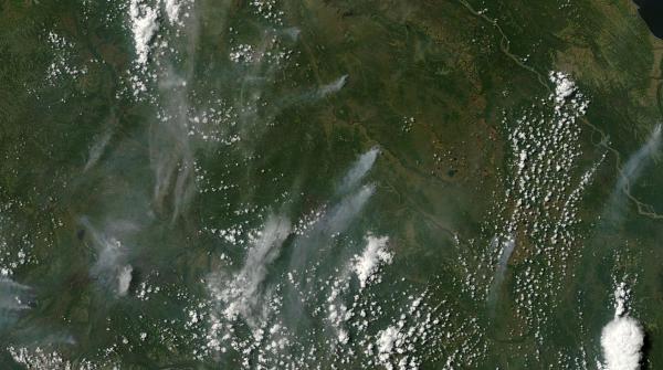
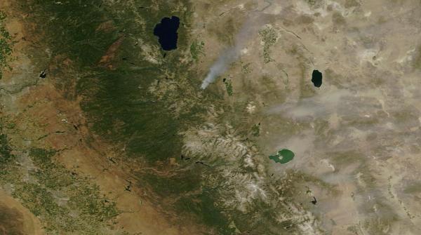
(MODIS satellite shot of wildfires erupting over a sweltering Southwestern Alaska on Sunday, June 21. Wildfires in permafrost regions of the Arctic like Alaska are particularly concerning as they are one mechanism that returns ancient sequestered carbon to the Earth atmosphere. A sign of a feedback set off by human warming that will worsen with continued fossil fuel emissions. Image source: LANCE-MODIS.)

Deadhorse, at the center of North Slope oil fields above the Arctic Circle set an all time record high of 82 degrees Fahrenheit (28 Celsius) on Sunday. That’s 3 degrees hotter than the previous all time record high of 79 degrees (26 C) set on August 16, 2004. The hottest reading for June at that location was a 68 degree (20 C) measure set in 2007. So, basically, Deadhorse just shattered the all-time record for June by 14 degrees (F) and the globally record hot summer of 2015 has only now gotten started.

Other locations experiencing new records for just Sunday included Kotzebue, which set a new all time record highest low temperature of 62 degrees (17 C). This reading broke the previous all time high minimum mark of 56 degrees (14 C), set in 1987. Bethel and Yakutat both tied their daily high minimum temperature records at 54 and 52 degrees (12 and 11 C), respectively.

And yesterday was just one day in long period of record heat for the State. Last month’s NOAA analysis showed temperatures fully 7 degrees Fahrenheit (4 C) above average. It’s a record heating that is now setting off severe wildfires all over Alaska. According to the state’s Wildland Fire Information Center, the relentless heat and dryness has turned spruce, hardwoods, brush, and tundra into dry fuels vulnerable to any ignition source. Over the past week, ignition has come in the form of lightning — with most of Alaska’s 2015 wildfires set off by nature’s spark.

As a result we are seeing nearly double the number of fires during June compared to a typical year. Fires that have already destroyed 30 structures, forced evacuations, and tapped Alaska’s firefighting resources to its limits.

Wildfires Burning in the Rainforests of Washington as Major Heatwave Approaches

Record hot temperatures and wildfires, unfortunately, are not just an issue for Alaska. They’re a prevalent concern all up and down Western North America. A zone that has seen several years of record hot temperatures and dryness. Extreme weather events fueled by such global warming-linked phenomena as a Ridiculously Resilient high pressure Ridge over the Northeast Pacific that has kept heatwave and drought conditions firmly entrenched throughout much of the region for months and years. An atmospheric condition that is also linked to a hot ocean surface water ‘Blob’ in the Northeast Pacific (which is itself implicated in a growing number of marine species deaths).

Paradise-Fire-June-17

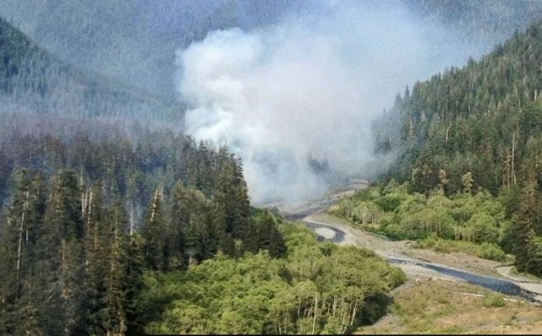
(Paradise Fire burning near a drought-shrunken creek in the rainforests of Olympia National Park, Washington. Image source: NPS and Wildfire Today.)

This week, the added heat also generated wildfires in unusual areas like the rainforests of Washington State’s Olympic Peninsula. Driest conditions since 1951 have resulted in a great deal of fire resiliency loss for forests in the region (1951 was the year of the historic Five Forks Fire, one of the worst ever to impact Washington State). Already, a rare early summer wildfire (called the Paradise Fire) has burned through 417 acres of forest.

Firefighters are doing their best to contain the blaze. But the record heat and dryness are multiplying fuel sources. Fires are enabled by dried lichens growing high up in the trees. When flames touch the lichens they rapidly ignite sending sparks to other lichen-covered tree tops. In this way, flames can leap rapidly from tree to tree under current conditions.

It’s very unusual to see fires in this rainforest zone. And when ignitions have occurred in those very rare cases, they have typically flared during late Summer and early Fall. So this June burning has fire officials very concerned — especially given the nearly unprecedented fire hazard conditions throughout the State. Conditions that are predicted to rapidly worsen as an extreme heatwave is expected to build through the coming weekend.

West Coast Heatwave Saturday

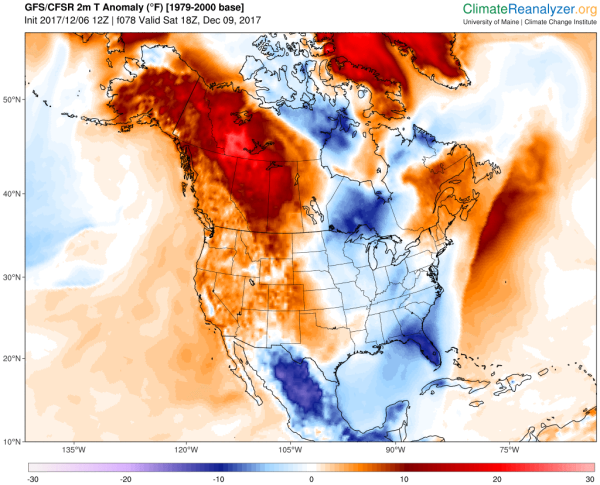
(A major heatwave is predicted to invade the US West and Northwest States this weekend. Washington and Oregon are predicted to experience temperatures more typical of desert sections of California and Arizona. Image source: Climate Reanalyzer.)

Temperatures over large stretches of Washington and Oregon are expected to climb into the 90s and 100s, possibly reaching the 110s (Fahrenheit — Celsius range from 33 to 45) by Sunday. For these typically cool, wet States, this brutal heat blow, should it emerge as predicted, will set off a spate of all time record high temperature readings, deepen drought conditions extending northward from California, and heighten fire conditions that are already in the range of worst ever experienced for sections of these States.

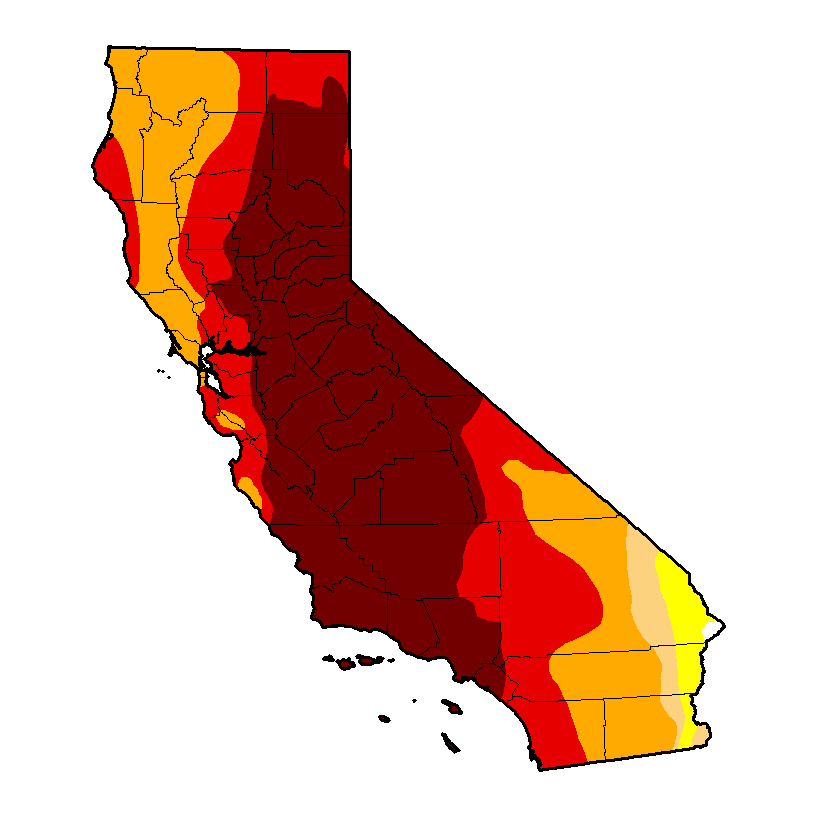
California Experiencing “Worst Fire Conditions On Record”

Moving further south along the U.S. West Coast we come at last to the drought hot zone that is California. A State that is now enduring its fourth year of drought. A drought that tree ring studies show is likely the worst such event in 1,000 years.

These harsh climate conditions were starkly highlighted this weekend as reports from State emergency planning officials now indicate that California is currently experiencing its worst fire conditions on record.

Ken Pimlott, Director of CAL FIRE noted:

We measure the fuel moisture content of all of the vegetation -the brush and the trees and we track that over the course of time and compare it month to month each year. And we put it through formulas and determine how much energy and how much heat it will put out when it’s burning. And we have seen -we saw it last year and we will see it again this year- we’ll be reaching records for potential heat output for times of the year that would normally not be burning in those conditions.

Wildfire nonexistent snowpack

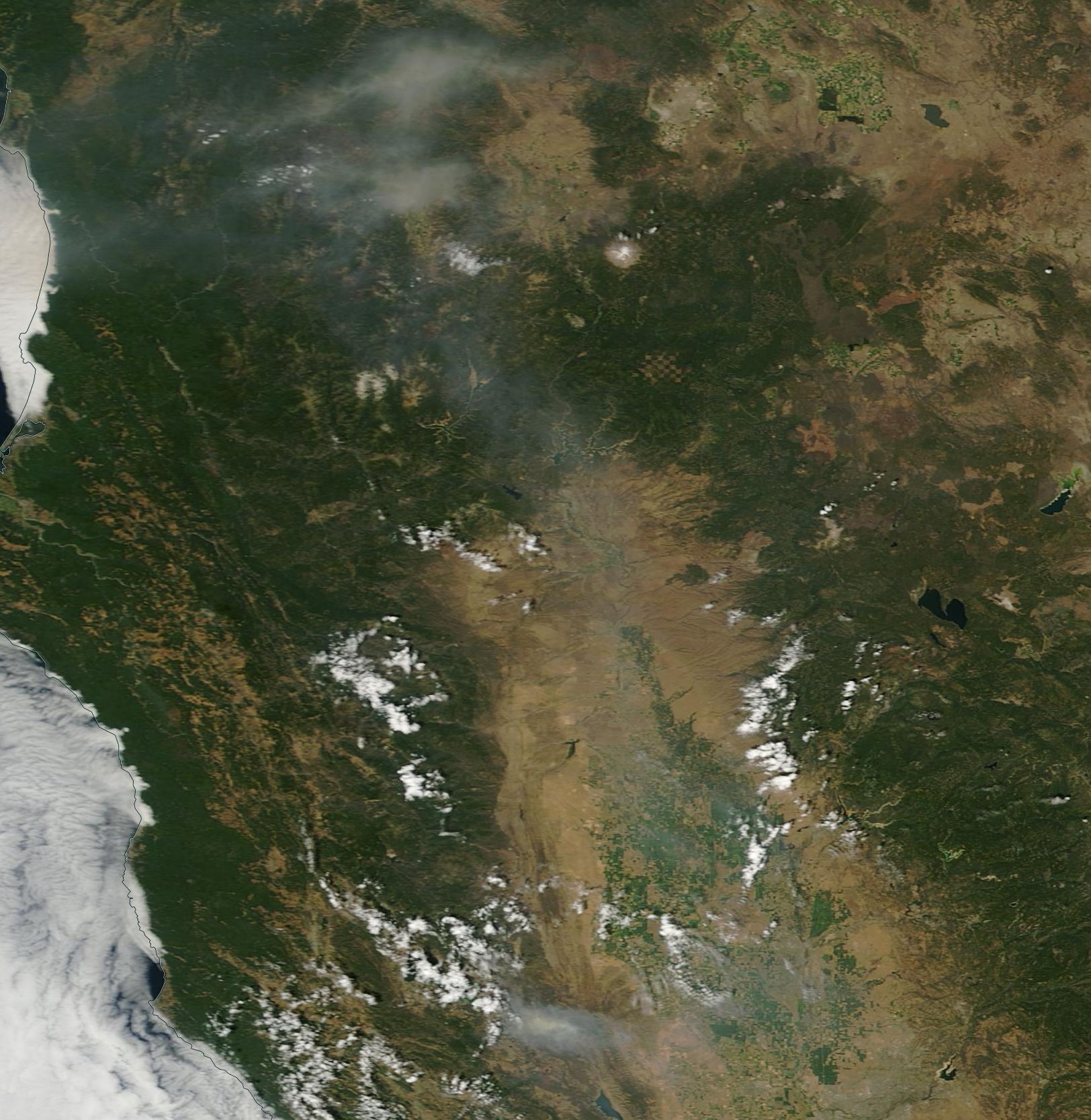
(Large wildfire burns in forests along the slopes of Sierra Nevada Mountains whose peaks are now entirely devoid of snow cover. Note that remaining glaciers are shown turning a dull brown in the June 21 MODIS satellite shot.)

So far this year over 1,100 wildfires have already ignited throughout the State. That’s nearly twice the typical number of 650 blazes popping up by this time of year. Exacerbating this stark context is a state water resource crisis compounded by non-existent Sierra Nevada snowpacks and dead trees that now number in the millions.

This is not Normal, Nor Should We View Widespread, Related Events in Isolation

Record and unusual Alaska, Washington, and California wildfires this season are, thus, not occurring in isolation, but as an inseparable feature of ongoing climate trends related to human-caused global warming. In this case, heatwaves are related to visible and extreme record ocean and atmospheric temperatures that have been ramping both globally and in the regions affected over past years and decades. And the fact that 2015 is continuing as the hottest year on record globally should also not be viewed as separate from the events witnessed all up and down the North American West Coast. Events that were largely predicted in many global climate models assessing the impacts of human based greenhouse gas warming on this vital national and global region.

We’ll end here by considering this thought — it’s only June, yet up and down the North American West Coast we are experiencing some of the worst heat, drought, and fire conditions ever recorded. It’s only June…

*   *   *   *

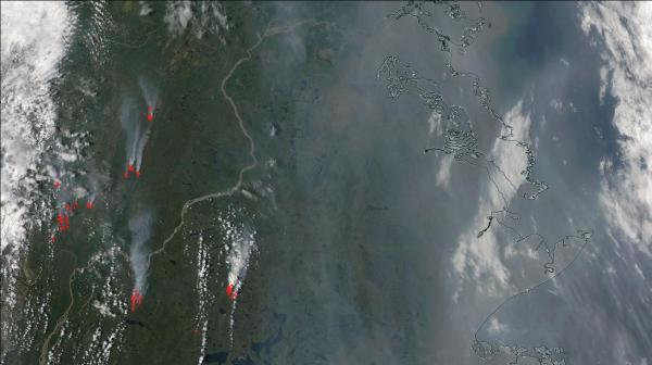
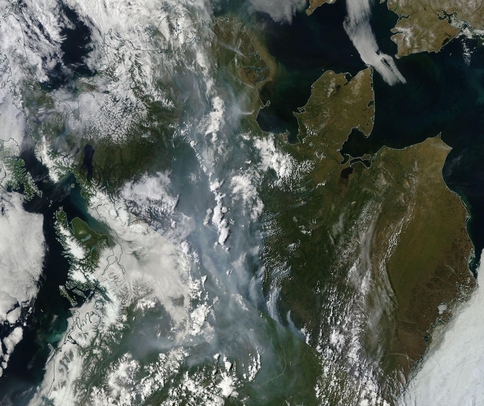
UPDATE NOON EST, JUNE 23, 2015: Satellite Imagery confirms that, over the past 24-48 hours, the wildfire situation in Alaska has continued to worsen. Widespread and large fires running throughout southwestern, central, northeastern and eastern Alaska today expanded and multiplied:

Wildfires Alaska June 22

(Fires flared to dangerous size across Alaska on June 22nd and 23nd. Image source: LANCE-MODIS)

These rapidly proliferating fires cover a diagonal swath stretching about 800 miles from southwest to northeast across the state. The fires are burning through Alaska’s permafrost zone and current intensity in the satellite image is similar to some of the worst Arctic fires we’ve seen during recent years. A substantial number of these fires feature smoke footprints indicating 5-10 mile active burn fronts. Smoke plume size is now large enough to become caught up in the Jet Stream and impact visual features of skies across the Northern Hemisphere.

Based on these satellite shots, it appears that Alaska is experiencing a heightening and very severe fire emergency — one that shows little sign of abatement over the next few days.

Links:

Deadhorse Sets New All-Time Record High Temperature

NOAA Global Analysis May 2015

Alaska’s Wildland Fire Information Center

More Than 100 New Fires Spring Up Across Alaska

PA Firefighters Heading to Alaska to Battle Wildfires

Wildfires Burn in Olympic Rain Forest

Climate Reanalyzer

LANCE-MODIS

California Fire Says 2015 Fire Conditions are Worst on Record

Die-off of Millions of California Trees Centered in Sierra Nevada

Hat Tip to DT Lange

Hat Tip to Andy in San Diego