
The North Atlantic and Arctic weather pattern is a real mess. Frequent episodes of severe polar warmth relative to normal conditions for this time of year have been a persistent feature. Arctic sea ice extents are at record lows. Meanwhile, the upstream atmosphere generated a record-smashing high pressure system and related abnormal warmth over the U.S. East on Wednesday.
(Severe warming, both at the surface and in the upper atmosphere over the Arctic helped to generate a polar vortex collapse during recent days. This collapse, in turn, generated a number of high amplitude waves in the Jet Stream — one of which produced a record high pressure ridge over the U.S. East Coast on Wednesday, February 21. Image source: Earth Nullschool.)
All these severe weather elements have ties to a climate change related condition called polar amplification. A condition that generates mass sea ice loss and extreme warmth at the northern pole, especially during winter. One that translates into more extreme ridge and trough patterns over the middle latitudes. And due to these features, the weather for both the Arctic and the North Atlantic doesn’t appear to be set to return to anything approximating normal for at least the next five days.
Forecast for More Extreme Warmth…
Far to the north, a long, thin extension in the Jet Stream is setting up to bring predicted above freezing temperatures to the North Pole by Sunday. The surface system anchoring that warm air invasion is a powerful low predicted to bomb out around 930 mb just off the coast of Greenland on Saturday. It will fling hurricane force winds and near to above freezing temperatures over coastal and northeastern sections of this frozen archipelago before translating that significant energy northward into the Arctic by early Sunday.

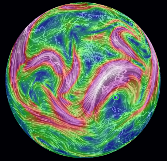
(Extreme warmth struck both the Arctic and the U.S. East on Wednesday, February 21st. A similar pattern is predicted to repeat by this weekend — pushing temperatures to near or above freezing at the North Pole even as the US southeast swelters. Image source: GFS/Climate Reanalyzer.)
Temperatures over central and northern Greenland are predicted to range between 10 and 25 C above average even as parts of the high Arctic spike to 30 C above average.
… Following Wednesday’s Record-Breaking Ridge
Though much of the recently most extreme weather action has been focused on the Arctic, the mid-latitudes have seen there fair share of climate change wrenched extremes.
Yesterday, a slot of warm air rushing northward built into a powerful ridge over the U.S. East Coast. This ridge was not any typical pulse of warm air at the surface running counter to a much cooler winter time atmosphere. It was heavy and it was tall — translating from the ground and well into the stratosphere.
So much heat generated summer-like conditions across the U.S. East. From the mid Atlantic to the northeast, temperature records last set as far back as the late 1800s were shattered. Washington DC saw 82 degree (F) temps. Vermont shattered several of its all-time record highs for February. Massachusetts saw temps hit 80 in Fitchburg. While New York’s Central Park also broke its all-time record of 68 F as the mercury struck 78 degrees yesterday. It was the strongest outbreak of heat ever to strike the northeastern section of the U.S. since record-keeping began back in the late 19th Century. Temperatures there were more typical of June and far less so of February.
All that extra heat translating so far into the upper atmosphere also generated convection and cloud formations more typical of summer — with cumulus clouds piling up over places like Atlanta.
And it wasn’t just temperatures and clouds that were increasingly trekking into outlandish parameters for February, it was the state of the atmosphere itself. For the central peak of the high pressure system provoking such powerful atmospheric anomalies was a stunning 595 dm at the 500 millibar level. This was the highest pressure ever recorded at the 18,000 foot level of the atmosphere. And the earliest time we’ve ever seen such a strong high pressure system off the U.S. East Coast previously was during June.
By the weekend, another warm air push is expected to invade the U.S. East. This time, it appears that temperatures in the Southeast will be most intense with highs hitting around 85 F across parts of Georgia and Florida even as a broad region of 75 to 80+ degree readings sweeps from the Gulf Coast on up through Virginia Sunday.
In the Context of Human-Caused Climate Change
We would be remiss if we didn’t note that increasing atmospheric thickness and powerful high pressure ridges are noted features of a warming global environment. New record high temperatures are also a climate change indicator — especially when they occur with such high prevalence and frequency. And this is the case even over the continental U.S. as a rapidly warming Arctic is helping to drive increasing hot and cold temperature extremes in the middle latitudes.


