
Civitas — the latin word for city and the root word for civilization. Civilization, in other words, is a collection of component cities. And, by extension, any major threat to a large number of cities is a threat to civilization itself. Such is the case with human-forced climate change.
*****
It’s a sad fact that many of the hundreds of coastal cities around the world are living on borrowed time. Current greenhouse gas levels — topping out near 408 parts per million CO2 (and 490 parts per million CO2e) this year — will need to fall in order to prevent 1-3 C of additional warming and 25 to 60 feet or more of sea level rise over the coming decades and centuries. And even if we somehow dialed atmospheric CO2 and CO2e levels back to 350 ppm, it’s likely that we’d still see seas eventually rise by 10-20 feet over the long term due to already destabilized glaciers in places like Greenland or West Antarctica.
But with fossil fuel burning continuing at near record levels globally, and with many corporations and political bodies around the world dragging feet on greenhouse gas emissions cuts, the level of heat-trapping carbon held aloft in our airs will continue to rise for some time. These vastly irresponsible actions will further heat the atmosphere and ocean — melting a greater share of the world’s land ice and forcing seas to ultimately rise even more. If CO2e exceeds a range of 550 to 650 parts per million — which could easily happen even under so-called moderate rates of fossil fuel burning before the middle of the 21st Century — then all the land ice on Earth will be placed under melt pressure. And that vast sum of ice melt represents about 220 feet of sea level rise long term so long as the greenhouse gas melt and heat pressure remains.

(Seas have been rising in concert with ocean warming and fossil fuel burning since the start of the 20th Century. At first, during the first half of the 20th Century, rates of rise were less than 1 mm per year. By the 1993 through 2016 period, sea level rise averaged 3.39 mm per year. And since 2011, the rate of rise appears to have steepened into the range of 4 to 6 milimeters per year. Image source: AVISO.)
Even more disturbing is the fact that in the geological past, glacial melt has not tended to process in a gradual, orderly fashion. Instead, initial gradual melt has, in deep history, often been punctuated by very large melt pulses as glacial systems rapidly succumbed to warming environments. And with human warming now proceeding at a pace about 20 times faster than the end of the last ice age, the risk for rapid melt has been greatly enhanced.
Despite continued snide claims by climate change deniers to the contrary — it really is a global emergency. One that includes difficult impacts now and a rising risk of far worse impacts to come. A very real kind of long emergency for human civilization and the natural world combined. One made no less worse by its current deceptively slow, if massive and inexorable, advance.
Hundreds of Cities Under Threat
Due to this threat posed by human-forced warming of the global climate system, cities that have lasted for hundreds or thousands of years now face a serious risk that they will ultimately be devoured by rising tides. Around the world, nearly half of the world’s approximate 4,000 cities with populations of greater than 100,000 people sit on or near the coastline, at elevations below 220 feet, or near bodies of water that are vulnerable to sea level rise. Under the continued pressure of human-forced warming on global ocean levels, a good number (5-10 percent) of these cities may begin to succumb to rising tides in as little as a 10-30 years. And, long term, over 30-300 year time frames, pretty much all are threatened if the world continues burning fossil fuels.

(Glacial melt, like from this pond-riddled and melt-darkened section of Greenland as seen on July 8 of 2016, threatens many coastal cities this Century. With human warming of the Earth atmosphere approaching 2 C, the threat of large glacial outburst flood events that rapidly push sea levels higher is rising. But even gradual sea level rise is already disrupting cities and the infrastructure that supports them. Image source: LANCE MODIS.)
New Orleans, London, Sydney, Shanghai, Los Angeles, New York, Alexandria, Amsterdam, Miami, Norfolk, Washington DC, and Toyko are just a handful of the major cities that are mostly low-lying or that contain large low-lying sections. And all are below the 220 foot sea level rise line that current levels of fossil fuel burning will begin to put into long-term play before mid-Century.
Infrastructure is the First Vulnerability
While complete inundation by rising tides is the ultimate issue, cities do not have to face such drowning to fall under threat. Water supplies, transportation nodes and arteries, food supplies, and energy production and distribution facilities all represent lynch-pins that, if disrupted, can take down a city’s ability to effectively function. And sea level rise often threatens many or all of these critical supports well before the problem of total inundation becomes an issue.
Miami, for example, now faces a combination of these threats due to the presently emerging early outlier effects of human-forced sea level rise. There, just one foot of rising tides since the early 1870s has now put 2.4 million of Miami’s residents and 1.3 million homes within 4 feet of the high tide mark. By 2015, that relatively minor sea level rise had increased tidal flooding by 50 percent. Roadways and neighborhoods were more frequently cut off by the rising waters — which prompted the election of Philip Levine as Mayor of Miami Beach and the implementation of his 400 million dollar project to elevate roads and add pumps.
The city’s water supply, provided by a fresh water aquifer running through porous limestone, is protected from ocean salt water intrusion by a fresh water barrier of canals. A mere six additional inches of sea level rise will render the current system both ineffective and vulnerable to over-topping due to heavy rainfall events.
Power Stations, Roads, and Airports
By 2030, Miami is expected to see between 6-10 more inches of sea level rise. By the end of this Century, it will probably see at least 6 feet — and that’s if we don’t pursue business as usual fossil fuel burning and if the world’s glaciers mostly behave themselves by not giving us a big, angry melt pulse in response to our insults. The result is that not only Miami, but the far-flung critical infrastructure that supports it is also under threat.
In this context, Miami’s airport is just 8 feet above the high tide line. The nearby Turkey Point Nuclear facility which provides energy to the city and a big chunk of South Florida is about 6 feet above the high tide line. And though its reactors are elevated by another 20 feet of concrete buttressing, this Century’s predicted sea level rise would flood its grounds and surrounding roadways — likely rendering it inoperable.
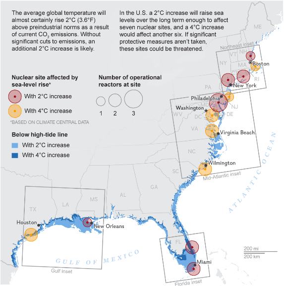
(Long term inland extent of sea level rise under 2 C and 4 C warming scenarios for US East and Gulf Coasts puts 13 nuclear facilities in the firing line. And an unexpected melt pulse or powerful storms riding on the top of sea level rise present a risk of flooded reactors. Such an inland rush of waters would also drown scores of coastal US cities, cut off roadways, flood aquifers, inundate crops, submerge airports, and sink conventional power stations. Image source: Nuclear Regulatory Commission, National Geographic, Climate Central.)
In the US, nine nuclear power stations are located on the coast. Another 13 are vulnerable to sea level rise. These sites are located near the ocean or along ocean fed rivers. They are ultimately vulnerable to sea level rise spurred by 2 or 4 degrees Celsius worth of warming. Without a herculean effort to not only reduce greenhouse gasses, but to recapture them from the atmosphere, 2 C warming is already locked in (this Century or longer term). The 4 C number is possible by late this Century under business as usual fossil fuel burning and is possible long term (500 year time scales) under the continuous 490 ppm CO2e forcing now in place.
Many large coal and gas power plants which also require heavy flows of water to support their operations are located near the coast. Oil refineries, which rely on shipping are often very close to sea level. Many major roadways are vulnerable to cut-off from sea level rise. And an amazingly large number of key airports are below a 20 foot elevation. A small sampling includes San Diego International Airport at 13ft in elevation, Santa Barbara — 10 feet, Vancouver –14 feet, Portland 20 feet, JFK — 13 feet, La Guardia — runway elevations between 7 and 21 feet, Reagan National — 13 feet.
New York Also Armoring Against Rising Tides
In the northeastern US, another city has recently had a harsh global warming wake-up call. About a foot of east coast sea level rise added to the approximate 13 foot storm surge of Hurricane Sandy to flood Staten Island and large sections of lower Manhattan. The local power station flooded — propelling the city into darkness even as the subway system drowned and one neighborhood filled with water and burned at the same time.
Post Sandy responses have resulted in a flurry of activity. Fully 60 billion dollars has been spent to rebuild and a good chunk of that has gone to making the city more protected against both storms and rising sea levels. High rises are now required to lift critical infrastructure such as water pumps and spare generators into the upper stories should lower levels flood. A big flood resiliency effort, starting with the 3 billion dollar construction of a 10 foot high, two mile long flood barrier in 2017, is underway. One that may buttress much of lower Manhattan behind a U shaped wall meant to deflect both rising tides and worsening storms. And a new park now features hills up to 70 feet above sea level.
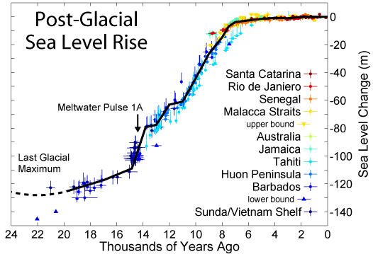
(At the end of the last ice age, as global temperatures approached 2 degrees Celsius above previous averages, large melt pulses from Antarctica and Northern Hemisphere Ice Sheets forced seas to rise by as much as 10 feet per Century. Human-forced warming is currently about 20 times faster than warming at the end of the last ice age. Current rates of warming and greenhouse gas emissions threaten to generate a 2 C warming by or even before the middle of this Century. Large melt pulses forced by such conditions would put cities like New York under risk of rapid inundation. Image source: Post-Glacial Sea Level Rise.)
These efforts appear to be aimed at facing off against another 1 foot of sea level rise for Manhattan by 2030 and a North Atlantic Ocean that is increasingly riled by powerful storms due to warming related climate instabilities. New York is digging in for the fight of its life. And for good reason. 10 percent of US gross domestic product funnels through this city of 8.5 million and over 100 billion dollars worth of real estate now sits in a high risk flood zone.
But build and buttress as it might, New York is hopeless in the long term if we can’t somehow stop human carbon emissions soon. If we can’t somehow start to draw carbon out of the air. If we can’t do these things, then New York, Miami and thousands of other coastal cities will ultimately face 25 feet of sea level rise or much, much worse. And the far flung infrastructures that they rely on will all, increasingly, need more and more costly and involved protections before they too succumb to the rising tides.
Links/Attribution/Statements:
Miami Nuisance Flooding Up by 50 Percent
As Waters Rise, Miami Beach Builds Higher Streets
Sea Level Rise — Are Coastal Nuke Plants Ready?
Sea Level Rise Risk to Coastal Nuclear Plants
Can New York Be Saved in the Era of Global Warming?
New Park Built to Withstand Epic Storms
Scientific hat tip to Dr. James Hansen
Scientific hat tip to Dr. Eric Rignot
Scientific hat tip to Dr. Jason Box
Hat tip to DT Lange
Hat tip to Scott
Hat tip to Genomik
Hat tip to Cate


