Fire in the Land of Ice: Massive Wildfires Rage Over Greenland and Siberia

Like never before, regions we typically associate with cold and ice are being over-run by wildfires. It’s a situation brought on by human-caused climate change. For our continued burning of fossil fuels is causing the Arctic to warm twice as fast as the rest of the globe. Under this oppressive influx of heat, the permafrost is thawing. And the fragile plants, frozen lands, and soils dependent on much cooler conditions simply cannot cope. Increasingly, and on greater and greater scales, they are burning.

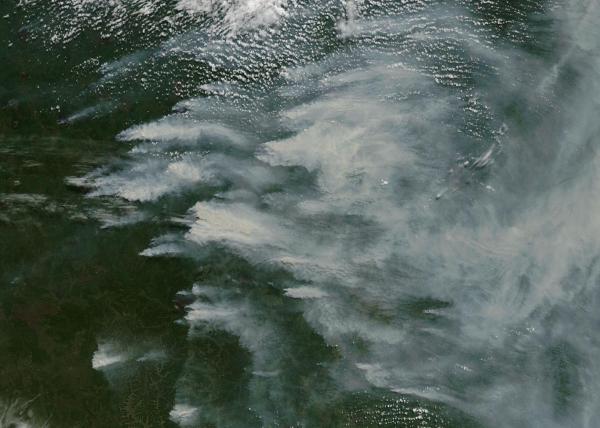
(Large Greenland fire captured by NASA’s Earth Observatory on August 7th.)

This past week, an outlandish wildfire ignited about 100 miles southwest of Ilulissat near the western coast of Greenland. The fire, visible by satellite, cast a long smoke plume even as it exploded into fierce intensity. The odd blaze subsequently generated a rash of expert chatter among Arctic observers on twitter even as news sources like NPR scrambled for contextual information.

Due to typically very low fire incidence, Greenland lacks a national forest fire information center. However, widespread satellite reports and news based observation provide a pretty clear context for this odd event. According to news reports from NPR, the fire itself is a complex of multiple blazes — the largest of which has expanded to 3,000 acres. It’s a massive forest fire. And it’s exceptionally odd seeing such a blaze light up in typically-frozen Greenland.

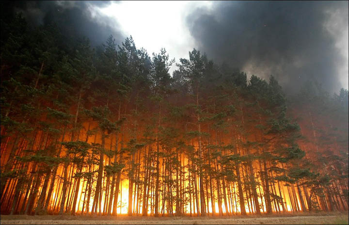
(Time lapse of massive Greenland wildfire provided by Meteos.)

The fire ignited as temperatures rose to near 70 degrees (F) across the region. A range that is well above average for this Arctic zone. And brisk, down-sloping winds likely helped to speed the fire’s initial rapid expansion.

Fires do occur at times in Greenland. But they are usually rare and small. This year’s fires, on the other hand, have been exceptional. Preliminary satellite observation indicates that as much as 8 times the typical number of active fires have ignited so far in Greenland during 2017. And there is every indication that this particular fire complex is the largest ever recorded on an island that is mostly blanketed by thousands of feet of ice.

(Analysis of active wildfire pixels in Greenland satellite analysis indicates a substantially increased rate of burning in 2017.)

The fire itself is burning through peatlands — which contain deep, carbon-rich soils. In many regions, thawed permafrost ultimately becomes peat. In addition, peat itself is very sensitive to climate change related warming. For as exceptional heat dries the peat, it becomes a deep, dense fuel for fires. When the fires ultimately come, they can eat far into the peat soils — burning 3 feet or more beneath the ground.

Though not as bad as fossil fuel burning for the climate system, peat fires do provide a troubling amplifying feedback to human-caused climate change if they become widespread and if large permafrost zones thaw into peat and subsequently burn. One researcher noted to the New York Times last year that: “It’s carbon that has accumulated over several thousands of years. If it were to be released, the global CO2 concentration would be much higher.”

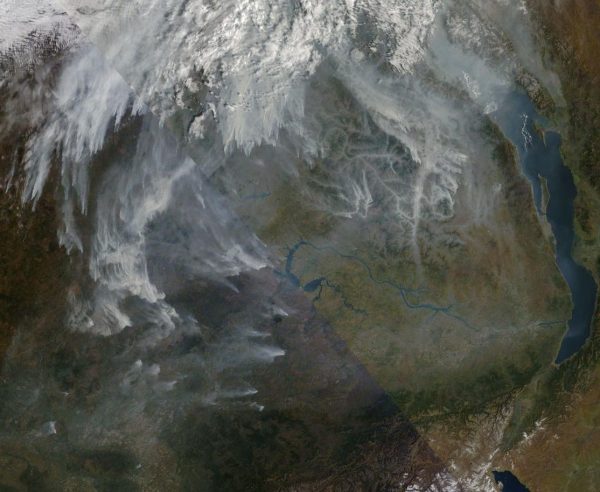
(Fires burning near the melting Greenland Ice Sheet are likely in a recently thawed permafrost zone. Permafrost contains a massive carbon store that if released will further exacerbate human-caused warming. Wildfires are one mechanism promoting that release. And as Arctic lands thaw and warm, more large fires are popping up across the Arctic. Image source: NASA Worldview.)

Jessica L. McCarty, an Assistant Professor of Geography at Miami University provides further context regarding the massive Greenland fires:

“They are likely occurring in areas of degraded permafrost, which are predicted to have high thaw rates between now and 2050 with some evidence of current melt near Sisimiut. Fires in the High Northern Latitudes release significant CO2, CH4, N20, and black carbon. A fire this close to the Greenland Ice Shelf is likely to deposit additional black carbon on the ice, further speeding up the melt.”

Siberian Wildfires Now Extremely Intense

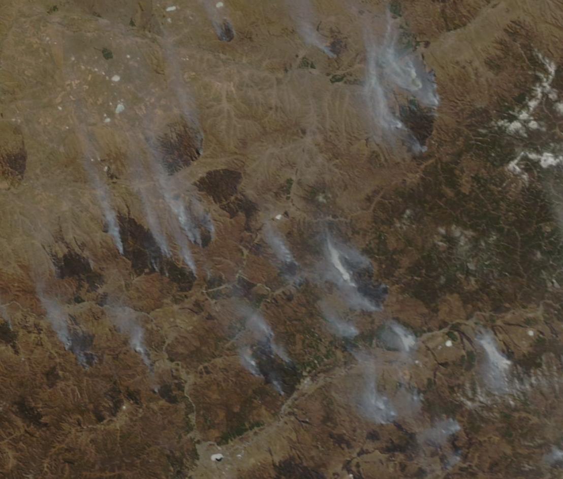
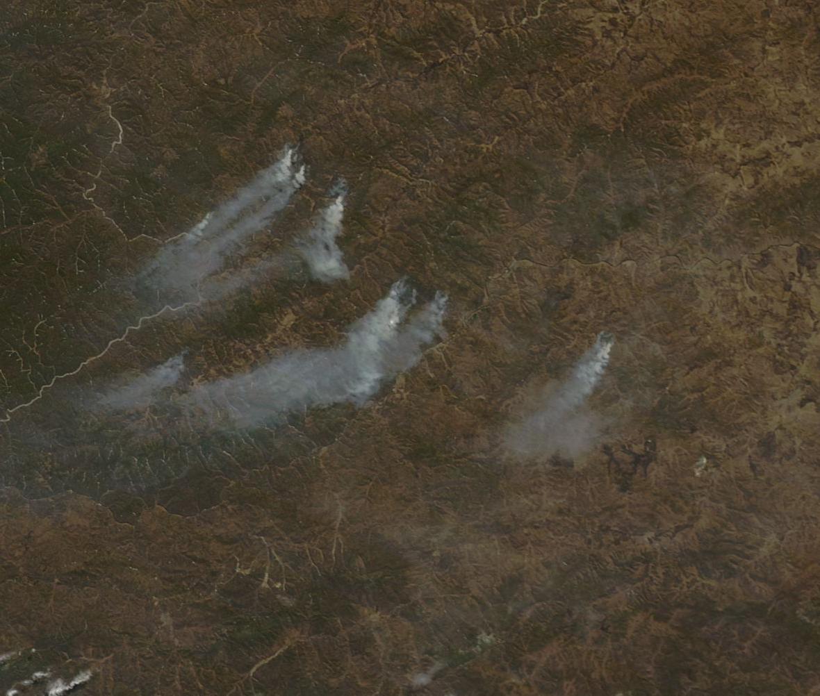
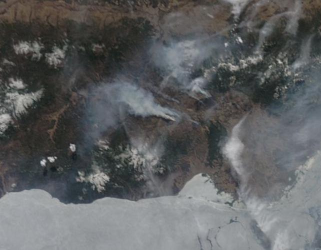
In many places throughout the Arctic, rapidly warmed and dried peatlands, forests and previously frozen permafrost zones are also burning. In Siberia the inky smoke plumes from massive fires today stretch for nearly 2,000 miles. Numerous fire complexes that dwarf the odd Greenland blaze are plainly visible in the satellite picture.

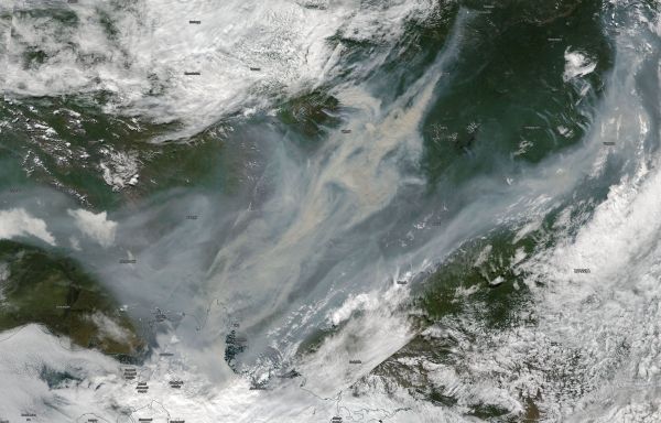
(The smoke plume in this image would blanket most of Greenland. Massive wildfires belch giant plumes of inky smoke over Siberia and the Arctic Ocean on August 9th. For reference, bottom edge of frame is 1,200 miles. Image source: NASA Worldview.)

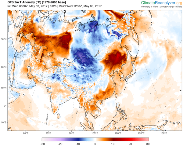
The fires come with extreme heat along a high pressure ridge zone stretching from Lake Baikal all the way to the shores of the Arctic Ocean. Today, temperatures in this Arctic and near Arctic region are ranging from 80 to 90 degrees Fahrenheit or as much as 35 degrees (F) above average.

With so much Arctic warming and thawing now ongoing, massive fires have become a frequent occurrence during summertime in Siberia recently. And this year, Russia has resorted to cloud seeding in an apparently fruitless attempt to suppress the enormous blazes.

Most of today’s fires are burning in Yakutia — which contains one of the largest global stores of permafrost carbon in the world. During recent years, permafrost has more and more rapidly thawed through this zone — providing a larger and larger store of peat-like fuels for the kinds of fires we are seeing today.

Links:

NASA Worldview

A Massive Wildfire is Now Burning in Greenland

Wildfire in Greenland

Wildfires are Burning in Greenland

Greenland Hit by Largest Wildfire on Record

Making Rain to Extinguish Wildfires

Hat tip to Andy in San Diego

Hat tip to Vic

Hat tip to Greg

Early Season Russia-Siberia Wildfire Outbreak Expands Due to Heat

An early Siberian and Asian wildfire outbreak that became apparent last week has continued to flare just south of the swiftly retreating freeze line. And while wildfires near Lake Baikal and further south and east toward the Russia-China border continue to flicker, a considerable outbreak has now flared up in Western Russian and Siberia along a zone straddling the Urals and just south of the Yamal Peninsula.

(Wildfires and hotspots run west to east across Russia and Siberia in this May 3 NASA satellite shot. Note the storm system near Lake Baikal which has recently suppressed early season wildfire activity there. Image source: LANCE MODIS.)

A trough dipping through Central Russia and Siberia has brought rain and cooler conditions — which has suppressed some of the previously extensive wildfire activity near and to the north of Lake Baikal. But temperatures in the range of 5-15 C above average along both the Russia-China border and in Western Russia have combined with warm, southerly winds to spur wildfire activity throughout these regions. In these zones, temperatures have been flaring into the 60s, 70s, and even lower 80s F (16-27 C) through sections. And such abnormal heat has helped to generate a high prevalence of newly-flaring early May wildfires.

Though wildfires in the east along the Russia-China border are still small and lack intensity, the region near the Urals is showing some significant flare-ups. Just west of the Urals near 56 north latitude burn scars as large as ten miles long by five miles wide appeared in the satellite imagery as fires ripped through the area on April 29 through May 3. These fires blanketed the region with 100 to 200 mile long smoke plumes even as the blazes steadily march northward.

(Wildfire flare up near 56 N just west of the Urals. For reference, north is left side of frame, south right side. Bottom edge of frame is approximately 80 miles. Image source: LANCE MODIS.)

In the east and near Lake Baikal permafrost often extends as far south as the Russia-China border. So many of the fires in this region are already burning in or near permafrost zones. In the west, permafrost is removed further north — becoming more common beyond the 60 degree north latitude line. Hotspots in the west are now approaching this zone, flaring as far north as the 59th parallel, but have yet to fully cross into it.

Over the coming days and weeks, wildfires in the permafrost zone will tend to become more extensive as spring advances. Such burning, during recent years, is now much more common than in the past. The increase is due to a considerable and rapid warming near the polar region that has averaged 2 times the larger global warming rate (about 0.15 to 0.2 C per decade for the world and 0.3 to 0.4 C per decade for the Arctic).

(Anomalous warmth is spurring wildfire flare-ups in both eastern and western Siberia and Russia today. Over the coming weak, abnormally warm temperatures are again predicted to flare again over the Lake Baikal region — which will likely reinvigorate the wildfires that have already begun burning there. Image source: Climate Reanalyzer.)

This human-forced warming due to fossil fuel burning is producing considerable permafrost thaw and creating new fuels for fires in a previously-frozen region. In addition, the added heat has generated more thunderstorms — producing more lightning strikes and other ignition sources. As a result of this warming, the added fuels, and a multiplication of fire ignition sources, Siberian wildfire season now ranges from April through September and often produces fires of a terrible magnitude.

Links:

LANCE MODIS

Climate Reanalyzer

Hauntingly Freakish Siberian Wildfires Now Flicker to Life in April

Hat tip to MlParrish

“We are Suffocating from Smoke” — For Russia, Climate Change is Already Producing Fires that are Too Big to Fight

“For one month we are suffocating from the smoke. The weather is hot, and there is a strong smell of burning…” — Residents of Bratsk, northwest of Lake Baikal, in a petition to Vladimir Putin pleading him to fight the fires now raging there.

*****

Let’s take a snapshot of the current moment from the climate change perspective: This year, global temperatures will probably hit between 1.2 and 1.25 degrees Celsius hotter than 1880s averages. This new heat, in a range likely not seen for 115,000 years, is catapulting us into dangerous new climate states. We’re starting to see the hard changes happen. Weather is growing more extreme, wildfires are worsening, the seas are rising, the glaciers are melting, and ocean health is declining. Threats of destabilization and disruption are ramping up. But compared to what we will see in the future if the world continues to warm, if we continue to burn fossil fuels, the seemingly rough changes we are experiencing now are minor and easy to manage.

These are the early, easy outliers of human-forced climate change. But for some, even for a nation as powerful as Russia, certain events have already overwhelmed emergency response capabilities.

****

lake-baikal-wildfires-september-28-2016

(Fire season should have ended by late August around the region of Lake Baikal in Russia. However, due to climate change-related influences, massive fires continue to burn through September. The above image is from today, September 28. Bottom edge of frame represents approximately 600 miles. Lake Baikal is visible in the right side of frame. Smoke from large fires currently covering approximately 2.5 million acres is visible throughout the shot. Image source: LANCE MODIS.)

Climate Change Spikes Fire Incidence in Siberia

Over the past decade or so, a rapid warming of Siberia has resulted in a dramatic increase in fire incidence. The vast boreal forests were thrust into hotter, dryer conditions by a human-forced warming of the globe. Meanwhile, permafrost thaw added its own massive and growing volumes of peat-like fuel for burning. As the years progressed, very large fires have erupted with rising frequency. Mostly underreported, according to Greenpeace and independent satellite analysis by experts, these fires have covered millions of acres year after year after year:

“If you look at the whole area over the past 30 years, there’s a significant increase in burned area that is very clear by the early 2000s,” Susan Conrad, a former U.S. Forest Service scientist who has spent decades researching the impact of fire on Siberia, told ClimateWire.

Often, fighting such fires has required the effort of thousands of emergency responders supported by hundreds of pieces of equipment. As a result, the growing size of these fires and the lengthening of the season in which they burn has put a strain on the coffers of an already cash-strapped Russia. Firefighting has thus been cut or set aside for instances when a city, town or vital piece of infrastructure requires defending. More and more, these great fires have been abandoned to burn on, uncontrolled.

2016 Lake Baikal Fires Too Dangerous to Fight

This year around the region of Lake Baikal, an unrelenting (climate change-related) drought combined with abnormal heat to produce massive fires. The fires raged and flared throughout the summer. As the typical wildfire season came to an end during late August, the fires continued to burn and spread. According to Greenpeace, the fires burning during September in this region alone covered nearly 5 million acres. That’s an area about the size of Massachusetts. Satellite shots of the massive fires were dramatic, revealing plumes of dense smoke spewing out over hundreds or even thousands of miles. Residents of cities and towns around Lake Baikal experienced terrible conditions due to a suffocating pall of dense smoke covering the area.

Despite the risk to public health and increasing cases where schools, communities and infrastructure were threatened by the fires, the Russian Emergencies Ministry has claimed that such large fires are increasingly uncontrollable. Spokespeople with the agency note that the fires are so intense that they present a danger to firefighting personnel. According to Radio Free Europe:

Aleksandr Bruykhanov, senior researcher at the Forestry Institute in Krasnoyarsk, told the Siberian Times that massive wildfires have become more frequent and cannot be fully controlled by the government. He said they will only be extinguished when rain returns to the region. …”The Emergencies Ministry won’t be able to help here but will only cause some extra work for foresters, who will have to rescue rescuers.” [emphasis added]

For One Month We are Suffocating From Smoke

Hundreds of firefighters have been deployed throughout the region in isolated efforts to stem the more eminent blazes. Near the city of Bratsk, 600 firefighters and about 123 pieces of heavy equipment were reported to be engaged with the fires on September 23. Unfortunately the firefighting has, thus far, been mostly unsuccessful.

lake-baikal-carbon-monoxide-spike

(High carbon monoxide readings north and west of Lake Baikal, Russia on September 28. This expansive plume of carbon monoxide is coming from very large fires burning in the region. Residents in a nearby city recently complained of carbon monoxide poisoning in a petition to Vladimir Putin to fight the fires. Emergencies Ministry spokespersons have claimed that the fires are increasingly uncontainable and that the best hope for stopping the fires is when rains return to the area. Image source: Earth Nullschool.)

Failure to control the massive burning has resulted in abysmal air quality for the region. In some cases, life-threatening conditions have been reported, with adults and children hospitalized. In Bratsk, a city of 250,000 people, thousands of residents are complaining of stifling smoke and incidents of carbon monoxide poisoning. A heavy pall of dense smoke has hung over the city for more than a month. The conditions there are so bad that 3,000 people have signed a petition to Vladimir Putin, urging him to deploy more resources to fight the fires, and stating that:

For one month we are suffocating from the smoke. The weather is hot, and there is a strong smell of burning and smoke. It is not possible to open windows, we cannot go out because we soon feel dizziness… Some adults and children are in hospital with severe carbon monoxide poisoning. We are for clean air! We want to breathe. We have that right. Do not remain indifferent to our health and our future!

Signs of Exhaustion at the Start of a Rough Climate Future

Exhaustion of emergency response resources is one of the big threats posed by climate change. In instances where entire regions see extreme weather conditions that are far outside the norm for an extended period of time, such as as severe droughts, floods, and fires, instances of exhaustion are more likely to occur. Exhaustion also occurs when events appear that are too large or intense to manage. It appears that firefighting efforts in Russia are starting to show some signs of exhaustion. Not good, especially considering the fact that these conditions are tame compared to what will happen in future years without some very serious climate change mitigation and response efforts now.

Whether they realize it or not, the residents of Bratsk are living at the start of a much rougher climate future. And they are just now starting to see a hint of bad conditions that will get worse as the world continues to warm and Siberia becomes one of the places to see the worst of it. It’s a situation caused by the very fossil-fuel burning that Putin currently promotes. This crisis of warming will cause more forests to burn, the fires to continue to enlarge, and the peat-like permafrost to become a fuel as it thaws.

The only way to stop this trend is to halt global temperature rise. That requires a very heavy lift, an international effort on a scale which the world has not yet fully committed to — an effort that would result in the fossil fuels Putin seeks to exploit being left in the ground in favor of far more benevolent energy sources.

Links:

Wildfires Increasingly Consuming Siberian Forests, Scientists Warn

People in Bratsk Petition Kremlin over Pollution from Forest Fires

LANCE MODIS

Wildfires Scorch World’s Largest Freshwater Lake

Oil Pipelines Threatened by Wildfires Amid Disputes over the Scale of the Destruction

Earth Nullschool

Hat tip to mlparrish

Hat tip to Colorado Bob


Scores of City-Sized Siberian Wildfires Spew 2,500 Mile-Long Plume of Smoke Over Northern Hemisphere

Today’s satellite pass by NASA’s LANCE MODIS array tells a dire story that practically no one in the global mainstream media is talking about. Northern and Central Siberia is burning. Scores of massive fires, some the size of cities and small states, are throwing off a great pall of smoke 2,500 miles long.

The vast boreal forests are lighting off like climate-change-enhanced natural fireworks. The tundra and permafrost lands — some of them frozen for hundreds of thousands to millions of years — are thawing and igniting. But for all of the loudly roaring fires, most of the major media reporting agencies have thus far produced only deafening silence.

Country-Sized Swath of Siberia is Covered With Wildfires

Massive Siberian Wildfires

(Large sections of Russia and Eastern Europe are blanketed by smoke from massive Siberian wildfires in today’s LANCE MODIS satellite shot.)

Imagine an enormous rectangle. At its northwestern end is the Yamal Peninsula and the shores of the Arctic Ocean. At its southeastern end is Lake Baikal, nearly 2,000 miles away. The vast expanse between is littered with fires. Some of these fires are relatively small. But others are vast, sporting firefronts 20-25 miles wide and revealing individual burn scars that, according to unconfirmed satellite analysis, appear to cover as much as 400 square miles of land.

And it’s not just a case of a smattering of these fires burning across the broad region. Rather, these massive fires are burning in multiple clusters, some of which would easily cover a region the size of the US state of South Carolina. The below image is a 300-by-220-mile box showing a section of North Central Arctic Siberia between north latitudes 58.5 and 66.2. Note that a significant portion of the land area in this satellite capture is covered by very large fires.

South Carolina Sized Siberian Region covered in smoke and flame

(Extensive swath of fires burn over North Central Siberia. Image shows a 300-by-220-mile area. Image source: LANCE MODIS.)

These very large fires are vigorously burning in a contiguous permafrost zone of Siberia. During recent years, as human fossil-fuel burning has continued to warm the Earth, such fires have become more and more common. Burning not only forest, the fires have also consumed duff, peat, and, increasingly, recently thawed sections of the permafrost. Though these fires are now in the process of activating a very large northern carbon store, and though such an event represents a dangerous amplifying feedback to human-forced warming, their occurrence and extent has been greatly underreported by the Russian government.

Fires Burning Near Yamal, Frozen Methane Deposits, Fossil Fuel Production Infrastructure

Further north, even the typically hard-frozen tundra regions are burning. Near the town of Nuya, along Obskaya Bay just east of Yamal, Russia and located in the fossil fuel development zone between north latitudes 66 and 67.3, enormous fires are raging. Like the recent Fort McMurray fire, these blazes appear to be burning near fossil fuel infrastructure and development zones.

Fires near Nuya Russia

(Large fires on the shores of Obskaya Bay in Northwestern Russia on July 18, 2016. Image source: LANCE MODIS.)

The Yamal region was also the location of the recent, and controversial, methane blowholes. The region sits over large gas deposits, some of which are in the form of clathrate. And some of the previously stable frozen deposits appear to be facing an increasing release pressure due to thawing, the invasion of warm liquid water into the subterranean environment, and, at the near-surface region, lightning strikes (which were previously unheard of in this zone) and wildfire pressure.

Up to 40-F-Above-Average Temperatures Blanket the Northern Fire Zone

Today, a good number of these fires burn north of the farthest northern extent of the Siberian tree line in 77 to 86 degrees F (25 to 30 C) temperatures. For some regions, these temperatures are 30 to 40 degrees F (17 to 22 C) above average. At the northwestern end of the vast, fire-marred range that now covers a land area larger than most countries, temperatures near the Arctic Ocean shore at 70.9° N, 81.4° E are 86 degrees F (30 C) — about 40 degrees F (22 C) above average. Not far away, the wildfires in the above image burn.

86 Degrees Near Arctic Ocean

(Extreme heat in the range of 30 to 40 degrees F above average temperatures [17 to 22 C] near Arctic Ocean shores greatly increases Arctic wildfire risk. Such extreme heat is related to human-forced climate change. As the Arctic warms at a rate two to three times faster than the rest of the globe, such fire-hazard and related potential for worsening amplifying feedbacks is also likely to increase. Image source: Earth Nullschool.)

Despite increasing prevalence and extent, Siberian wildfires have continued to be underreported during recent years, despite the fact that out of all major Arctic permafrost and boreal forest regions — Alaska, Canada, and Siberia — Siberia has shown the visibly greatest increase in wildfire frequency and extent. This is likely due, in part, to a now-documented underreporting of wildfire extent by the Russian government.

Links/Attribution/Statements

Earth Nullschool

LANCE MODIS

Yamal Map

Methane Blow Holes

Russia Significantly Under-Reporting Wildfires

Hat tip to Colorado Bob

Hat tip to DT Lange

Hat tip to Jim Benison

Wildfires in the Land of Frozen Ground — 1,000 Mile Long Pall of Smoke Blankets Burning Siberia

It’s another day in a record hot world. And in a few hours, just below the Arctic Circle in Siberia, the temperature is predicted to hit 33.2 C (or just shy of 92 degrees Fahrenheit). According to climate data reanalysis, that’s about 15-20 C above average for this time of year over a land filled with cold weather adapted boreal forests and covering ground that, just below the first few feet of duff, is supposed to be continuously frozen.

image

(33. 2 C [92F] temperatures run to within 3.7 degrees of Latitude south of the Arctic Circle [66 N]. These are readings in the range of 15-20 degrees Celsius above normal and are likely record ranges for the area. Nearby, enormous Siberian wildfires now burn. Image source: Earth Nullschool.)

All along the southern and western boundary of this region of extreme heat, very large wildfires now rage. Sparking near and to the east of Lake Baikal during early April, May and June, the fires have since run northbound. Now they visibly extend along an approximate 1,000 mile stretch of Central Siberia ranging as far north as the Arctic Circle itself.

As recently as June 25th, Russian authorities had indicated that around 390 square miles had burned along the southern edge of this zone in Buryatia alone. For other regions, the tally is apparently uncounted. An unreported number of firefighters are now engaged with these blazes and have currently been assisted by an additional 150 Russian Army personnel. The Interfax News Agency also reports that 11,000 personnel from the Russian Army are currently on standby to battle the massive fires, should the need arise.

Massive Siberian Wildfires June 30

(NASA’s LANCE-MODIS satellite shot for June 30, 2016 shows enormous smoke plumes rising up from intermittent wildfires apparently burning across an approximate 1,000 mile stretch of Central Siberia. For reference, right border of frame is approximately 1,200 miles.)

Today’s Siberia is a vast thawing land and armies of firefighters are now apparently necessary to stop or contain the blazes. Already interspersed with deep layers of peat, melting permafrost adds an additional peat-like fuel to this permafrost zone. When the peat and thawed permafrost does ignite, it generates a heavier smoke than a typical forest fire. This can result in very poor air quality and related incidents of sickness. During 2015, a choking smog related to peat fires forced an emergency response from Russian firefighters. The thick blanket of smoke currently covering Siberia (visible in the June 30 LANCE MODIS satellite shot above) now blankets mostly uninhabited regions. But the coverage and density of the smoke is no less impressive.

Peat and thawed permafrost fires have the potential to smolder over long periods, generating hotspots that can persist through Winter — emerging as new ignition sources with each passing Summer even as Arctic warming intensifies. During recent years, wildfires in the Siberian Arctic have been quite extensive. According to Greenpeace satellite analysis, 2015’s wildfires covered fully 8.5 million acres (or about 13,300 square miles). These reports conflict with the official numbers from Russia. Numbers Greenpeace indicates fall well below the actual total area burned.

(Wildfires erupt to the north and west of Lake Baikal in this June 27 rendering of the Japanese Himawari 8 satellite imagery.)

Thawing permafrost under warming Siberian temperatures not only generates fuel for these wildfires, it becomes an additional source of greenhouse gas emissions. And as the area of land wildfires burn in the Arctic expands together with the heat-pulse of human-forced warming, this amplifying feedback threatens to add to an already serious problem.

Links:

Earth Nullschool

LANCE-MODIS

Climate Reanalyzer

Russian Volunteers Seek a Foothold as Wildfires Rage in Siberia

Interfax

Hat tip to Colorado Bob

Hat tip to Andy in San Diego

Hat tip to DT Lange

“The Dry Land Burned Like Grass” — Siberia’s Road to a Permaburn Hell

(Residents of the Trans Baikal region of Russia flee through a raging permafrost fire on April 13 of 2015. Video Source: The Road to Hell Recorded by: Vladislav Igorevich.)

The script reads like a scene from some post-apocalyptic disaster film.

Frigid Siberia begins an epic thaw — a thaw set off by an unstoppable dumping of heat-trapping gasses into the atmosphere by human fossil fuel industry. Finally, after years of warming, the thawing land itself becomes fuel for fires. A thick layer of peat-like organic material that serves as kindling to the heat-dried trees and grasses atop it.

Immense blazes ignite in April — fully 100 days before the usual fire season in late July. The fires explode to enormous size, doubling in area in less than a day, covering scores to hundreds of square miles. Residents flee or face off against walls of raging flame in bucket and hose brigades. Military units descend on the regions affected to fight blazes and prevent looting. The fires are freakish, starting from nowhere at a moment’s notice. Eyewitnesses at the scene of one fire describe the surreal situation saying: “… the dry land burned like grass.”

inside_chita_fores

(A wall of fire confronts residents of Chita, Russia this week as local townsfolk prepared to defend their homes and livelihoods from the inferno. Image source: The Siberian Times.)

But for two regions of Russia, that’s exactly what happened this week.

In Khakassia, a region of southern Siberia bordering Kazakhstan and Mongolia, massive blazes ripped through a broad permafrost thaw zone, impacting 39 villages, killing 29 people and leaving thousands homeless. By Thursday, many of these massive fires were finally extinguished — leaving miles wide scars over a smoldering and blackened land.

Hundreds of miles away in Trans Baikal, the story was also one of hellish inferno. There, wildfires erupted from the thawing permafrost zone — engulfing forests, burning dry land, destroying hundreds of homes in more than 9 villages, and killing four people. One wildfire alone surged to nearly 400 square miles in size and threatened numerous settlements near the city of Chita. There, locals are still fighting the blaze in a desperate effort to preserve life and property.

Chita Fires April 17 2015

(Satellite image of fires and large burn scars in Chita, Russia on April 17 of 2015. For reference, bottom edge of frame is 120 miles. Note that some of the burn scars in this satellite shot stretch for 20 miles at their widest point. Image source: LANCE MODIS.)

In total, nearly 50 villages and towns have now been affected, 33 lives have been lost, four more have gone missing, nearly 7,000 people are now homeless, and more than 6,000 domestic animals have been lost to the fires. These are the first, early casualties in a fire season stoked by climate change that will flare off and on for at least the next five months. A fire season that will likely see immense plumes of smoke covering broad sections of the Northern Hemisphere, involve Canadian and Alaskan permafrost zones, and see wildfires burning all the way through Siberia to the shores of the Arctic Ocean.

And so we are just at the start of a long road through another hellish Arctic fire season, one enabled and made far, far worse by a current and very rapid rate of human-forced warming.

Links:

Fire Rages on as Death Toll Reaches 33

LANCE MODIS

The Road to Hell

Vladislav Igorevich

Unprecedented Early Start to Perma-Burn Fire Season

Siberia Ravaged by Forest Fires

Hat tip to Alexander Ac

When April is the New July: Siberia’s Epic Wildfires Come Far Too Early

Rapidfire hotspot analysis

(NASA LANCE MODIS Rapid Fire hotspot analysis of extreme fire outbreak in the Amur region of Russia on April 28, 2014. In this shot, the Amur runs west to east through the frame. To the right is the Pacific Ocean [off frame] to the left is a corner of Russia’s massive Lake Baikal. The red spots indicate currently active fires. Image source: LANCE-MODIS)

What we are currently witnessing is something that should never happen — an outbreak of fires with summer intensity during late April at a time when Siberia should still be frigid and frozen.

*    *    *    *    *

Last year, during late July and early August, a series of epic wildfires raged to the north and west of Russia’s far eastern Amur region. About a week later, the skies opened up in a ten-day-long deluge that pushed the Amur River bordering Russia and China to levels not seen in the entire 150 year span of record-keeping for the region. Whole cities were submerged as the Amur leapt its banks to form a kind of massive inland sea.

The floods promoted strong growth in the region, penetrating permafrost zones to enhance melt, providing major fuel sources for fires should they re-emerge. Come winter, a persistent warm ridge pattern in the Jet Stream transported hotter than usual air over this region. The winter was far, far warmer than it should have been. And when spring came, it came like the onset of summer.

Last week, temperatures soared into the 70s and ever since the beginning of April, freakishly large fires for so early in the burn season erupted. By April 23rd, the Russian fire ministry had logged nearly 3,000 fires. The outbreak was so intense that, just a few days ago, more than 5,000 pieces of heavy equipment and an army of firefighters were engaged throughout a large stretch of Russia from the still frozen shores of Lake Baikal to the far eastern Amur region.

But last night’s LANCE-MODIS satellite pass brought with it unexpected new horrors:

Massive Burn Scars

(Two massive wildfires in excess of 200 square miles burning in the Amur region of Russia on April 28, 2014. Image source: LANCE-MODIS.)

Two massive burn scars devouring huge sections of land in the Amur region of Russia.

For scale, the ribbon of blue traveling north to south beneath the first massive fire is a mile-wide tributary to the Amur river called the Zeya. Using the scale provided by LANCE MODIS, we see that the fire at upper left is currently about 15 x 18 miles (270 square miles) in area and that the fire at lower right is about 23 x 20 miles (460 square miles) in area.

Even during Russia’s recent global warming-spurred epic fire seasons of 2010 to 2013 fires of this scope and obvious visible intensity didn’t come up in the satellite imagery until the most intense periods of summer heating during late June through early August. Today, we have monster fires comparable to those which burned during Russia’s worst ever recorded fire seasons, at their height, burning next to snow covered regions in late April.

As a last reference, look at the ice covered river in the far lower right corner of the above image. That swatch of crystalline white — yes, it’s a large estuary apparently being dwarfed by the massive fire burning just above it. Beneath wide body of still frozen water is what appears to be a ‘small’ plume of smoke. It’s worth noting that this smoke plume issues from a recently burned region covering fully 15 square miles. By comparison, the fires above each cover areas comparable to Guam, half of Rhode Island, or the massive ice island recently broken off from the now doomed Pine Island Glacier (PIG) — B31.

Unfortunately, these massive fires aren’t the only blazes covering extraordinary swaths of Russian land during late April. Moving west to the shores of the still partly frozen Lake Baikal, we find numerous fires burning beneath a sea of smoke in the lowlands between two, still snow-capped highlands.

Lake Baikal Fires April 28

(Sea of Smoke and Fire north and west of Lake Baikal on April 28, 2014. Image source: LANCE-MODIS.)

The entire roughly 200 x 200 mile (40,000 square mile) region is covered by the steely gray smoke of previous and ongoing blazes.  Peering down through the dense shroud, we see numerous thick smoke plumes issuing from still out of control fires. The freakish prematurity of these blazes is readily apparent in the visible ice still covering much of Lake Baikal and also in the snow still doggedly clinging to the nearby mountainous highlands.

A vicious combination of thawing permafrost, a rapid increase in average temperatures throughout Siberia and driven by human warming, and the vulnerability of the active soil layer and related vegetation to rapid drying appears to be turning this region into an ever more explosive fire trap. Risk of wildfire is dependent on both heat and fuel. But with the permafrost containing an almost inexhaustible layer of either drying peat or venting methane and with temperatures now rising at twice the already rapid global rate, the potential for burning in or near the violatile permafrost thaw zone may well be practically unlimited.

These extraordinary and anomalous conditions, combined with a very intense early season warming, what appears to be a persistent and developing heat dome over Eastern Russia and adjacent Arctic Siberia, a very rapidly receding snow line, and, potentially, an amplifying effect from an emerging El Nino in the Pacific, results in a very high continued risk for both extreme and record fires throughout the spring and summer of 2014.

Links:

LANCE-MODIS

Russia Experiences Great Burning

A Song of Flood and Fire

A Dangerous Dance of Frost and Flame

100 Fires Burn 12,000 Hectares in Russia

Doomed Pine Island Glacier Guam-Sized Iceberg into Southern Ocean

Hat tip to Colorado Bob

A Dangerous Dance of Frost and Flame: More Than 100 Wildfires Now Raging Along Siberian Melt-Freeze Line

Anomalous, global-warming-enhanced, fires continued to erupt across Eastern Russia this week, chasing a rapidly receding freeze line north and into zones still frozen, but starting to shake off ice cover far too soon for comfort.

According to reports from Radio Free Europe, more than 5,000 pieces of heavy equipment and many more firefighters are now battling blazes throughout Siberia this week. As of April 20th, more than 100 blazes were reported in numerous regions including: the Orenburg area around Lake Baikal, the Amur region, the Birobidzhan Autonomous Oblast, the Primorsky Krai, and the Far Eastern region of Russia.

Multiple Wildfires Raging in the Amur Region of Russia

(Multiple wildfires raging in the Amur region of Russia on April 23, 2014. Image source: LANCE-MODIS.)

The fires come as temperatures ranging from 5-18 C above average continued throughout a region that has experienced hotter than normal temperatures all winter and on into spring of 2014.

For example, the average April high temperature for the region of Lake Baikal is typically a frigid 28 F, while this week is expected to see highs in the lower to middle 40s. Further east, the temperature extremes are more radical. In Amur Blagoveshchensk, the average low is about 27 degrees F for this time of year, the average high, about 50. But today the low was 52 and the high is forecast to be 78 — 25 and 28 degrees above average respectively.

All across Eastern Russia, the story is the same: above average warmth, early thaw, summer-like temperatures in spring time. It has been this way day after day, month after month. Since 2010, the story has mostly been the same: early thaw, record or near record heat, amazing fire hazard. Even more concerning, the situation is steadily growing worse.

How Global Warming is Turning the Siberian Tundra into a Firetrap

Winters during cold regions are typically comparatively dry events. Though snows may pile up, the water content of the snows amount to much less moisture than it would seem. During spring, a gradual thaw ensures this moisture keeps the thin, top layer of soil above the permafrost (called the active layer) from drying out too rapidly. Typically only inches to a few feet in depth, this layer is far more susceptible to drying than a deeper layer with access to greater moisture sources at depth. But only frozen or melting permafrost currently rest below the active layer, creating a moisture barrier or worse — adding a potential fuel source for wildfires.

Eastern Russia in a Hot Zone

(Eastern Russia in a hot zone. Hot atmospheric ridge and coincident extreme temperature anomalies stretching from Southeast Asia, up through China and Eastern Russia and on up through the polar region. Information Source: NOAA Global Forecast Systems Model. Image source: University of Maine.)

In years of warmer than usual temperatures, as has happened more and more often under the current regime of human-caused warming, the thaw occurs rapidly and the active layer quickly dries out. This loss of moisture amplifies into a kind of tundra drought that can block atmospheric moisture flows and prevent rainfall, compounding the drying problem until the more energetic storms of summer arrive.

In addition, expanding zones of thawing permafrost provide two added fuel sources for wildfires. Tundra melt in high water content areas forms into wet thermokarsts, mires or melt ponds that vent methane gas in high enough concentration to burn. Tundra melt that rapidly dries after thaw forms into a peat-like basement layer that can burn and smolder for long periods once ignited.

On average, temperatures have been rising by about .4 C per decade throughout Siberia. So almost every spring now falls into what would typically be called a hot year. In addition, amplification of Jet Stream wave patterns deliver proportionately more heat to regions in the up-slope of these high amplitude atmospheric pulses, forming hot, high pressure ridges. And this year, the heat ridge has consistently formed over China, Mongolia and Eastern Siberia — the region of the current large fire outbreaks.

Russian wildfire burning on the shores of still frozen Lake Baikal April 23 2014

(Siberian wildfires burning on the shores of still-frozen Lake Baikal in southern Siberia on April 23, 2014. Image source: LANCE-MODIS.)

As a result, what we are seeing is an extraordinary outbreak of intense wildfires directly adjacent to still melting snow and frozen lakes. A surreal event that reminds one of the ever-at-war frost and fire giants of ancient Viking legend. But these giants, the fire giants at least, are a direct result of an ongoing and ever increasing human-caused heating of our world.

Links:

Radio Free Europe

University of Maine

NOAA Global Forecast Systems Model

LANCE-MODIS

Melting Permafrost Switches to Nasty, High-Gear Methane Release

Blagoveshchensk Weather

Lake Baikal Weather

Earth Under Fire