
Large swells and high tides continued to batter the U.S. East Coast today as a storm that is predicted to become yet another nor’easter began to gather over the Central U.S.
A broad low pressure system that slammed the mid-Atlantic and Northeastern U.S. this weekend with flooding, massive waves, and wind gusts of up to 93 mph was still hurling rough seas and storm tides at the U.S. East Coast on Monday. Such widely-varied locations as coastal Florida and New Jersey were experiencing high water, beach erosion, raging surf and minor coastal flooding. Officials were warning people to stay off the beach and away from riled seas as crews rushed to clear debris.
The storm gained extreme intensity that was likely peaked by a number of climate change related factors including warmer than normal sea surface temperatures, a blocking high over Greenland that was likely impacted by a recent polar warming event, and higher sea levels resulting increasingly severe tidal flooding during the storm’s peak.

(A massive low pressure system that knocked out power to hundreds of thousands and flooded the Northeast coastline this weekend still churned off the U.S. East Coast on Monday — lashing shores with rough surf and minor flooding. Image source: Earth Nullschool.)
Inland, nearly a quarter million people were still without power from Virginia through Maine — down from a high of around two million at the weekend storm’s peak. However, utilities are saying that it may take days to fully restore power to some locations. As repair crews were scrambling, another major storm was starting to gather over the Great Plains — with a high pressure system across Florida drawing very moist air from over a much warmer than normal Gulf of Mexico and into the developing storm’s circulation.
Over the next 24 hours, the new storm is projected to track eastward — crossing to the Ohio River Valley region by late Tuesday. On Wednesday, the low will transition energy into a developing storm off Virginia and the Outer Banks. This low is then expected to rapidly intensify as it moves northward — developing strong onshore winds with gusts of 45-65 mph crossing coastal Delaware, New Jersey, Long Island, Connecticut, Rhode Island and Massachusetts by late Wednesday and into early Thursday.
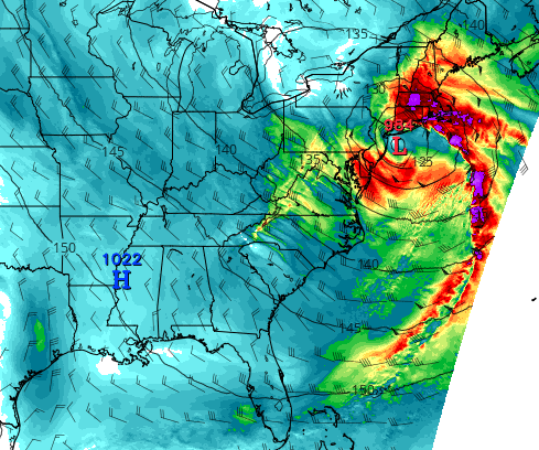
(Models show another powerful low pressure system battering the Northeast Coast with 45-65 mph winds by early Thursday. Image source: Tropical Tidbits.)
Presently, the storm is not expected to be as strong as the massive system that slammed the Northeast and Mid-Atlantic this weekend. However, gale force to storm force gusts are presently predicted, and forecast storm strength has been trending toward higher intensity in recent model runs.
In addition, climate change related factors like a warmer than normal Gulf of Mexico, much warmer than normal sea surface temperatures in the Gulf Stream, higher sea levels, and a large blocking high over Greenland are contributing to this most recent storm’s expected intensity. With hundreds of thousands still recovering from this weekend’s historic storm, and with so many factors now in play that could serve to further spike a new storm’s intensity above those presently expected, this is a developing situation that bears watching.


