10-15 Foot Waves Break Seawall at Barrow, Alaska

This is not something that is normal for typically ice-choked Barrow, Alaska. Today, 25 to 35 mile per hour winds and fetch-driven, 10-15 foot high waves are breaking through coastal barriers and flooding the streets and homes of a town that is used to far more placid seas.

Barrow Flooding

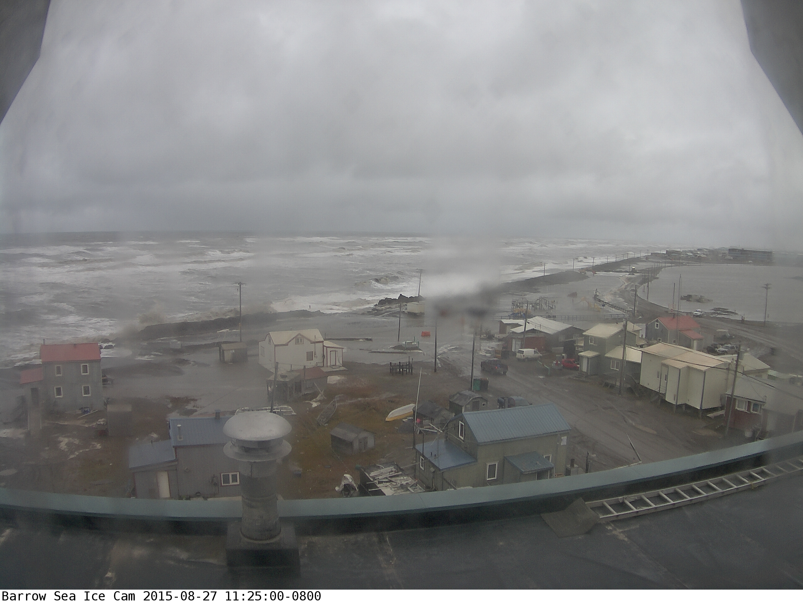
(Recently, Barrow city officials had a barrier of sand erected to protect structures from the newly ice liberated waters of the Beaufort Sea. Today, a strong coastal low pressure system’s surf smashed that barrier, flooded the coastal road, broke a channel through to an inland lake, and swamped numerous structures. Image source: Barrow Sea Ice Webcam.)

*    *    *    *    *

There’s been quite a lot of potential storm energy building in the Beaufort Sea this season. Nearby waters in the Chukchi have ranged between 3 and 5 degrees Celsius above average. Warmth, moisture and low pressure systems have flooded in from the Pacific off the back side of the Ridiculously Resilient Ridge to the south. It was a pool of warmth and heat just waiting for a trigger.

As August swung toward September, the near polar regions began to cool even as the Summer sun retreated. Temperature differentials between ice free sections of the Chukchi and Beaufort and remaining ice covered regions in the Central Arctic Basin hit new extremes. And, yesterday, a strong low pressure system began to develop off the Northern Alaskan coast (see video of yesterday’s building surf here).

image

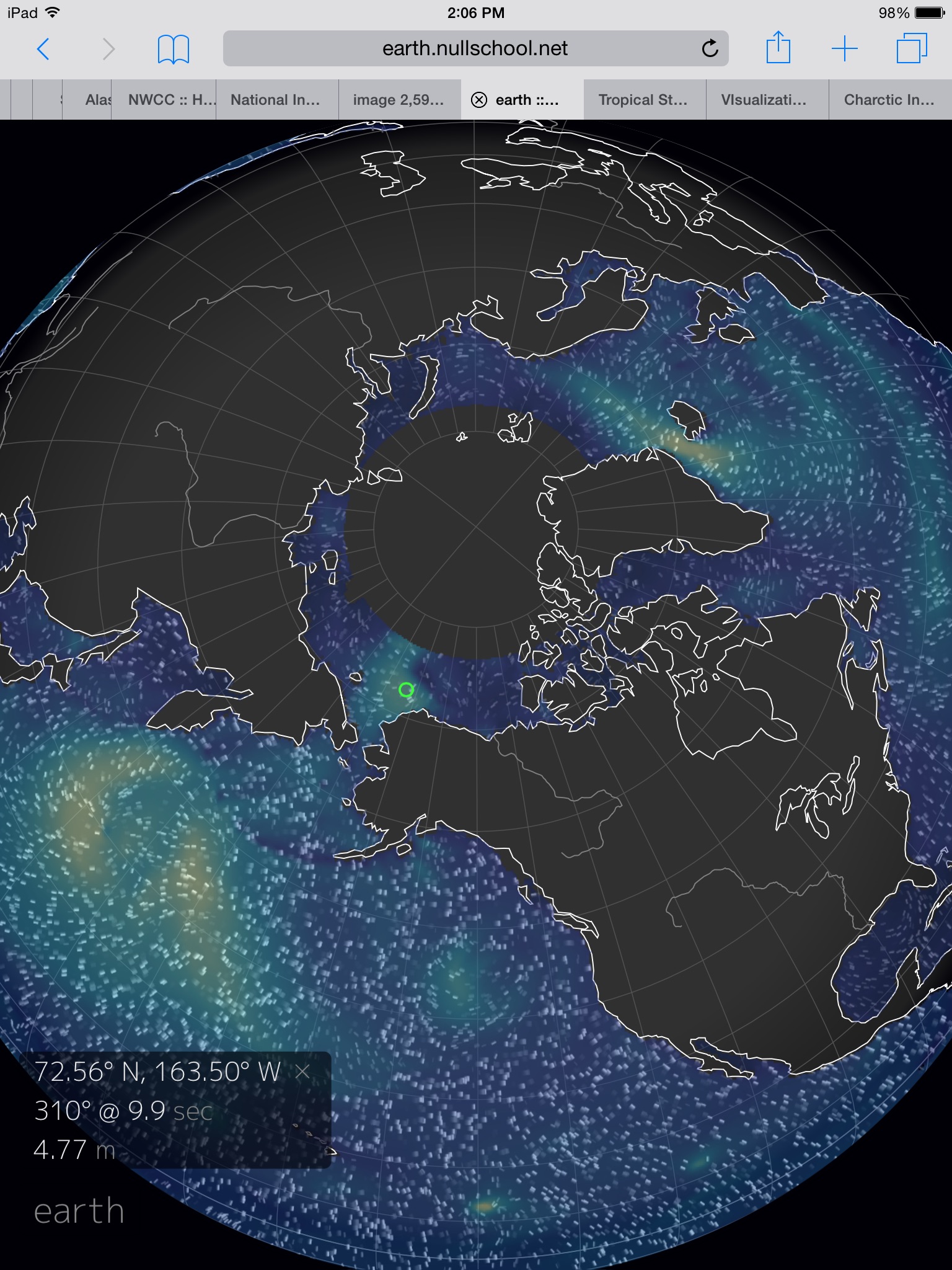
(Fifteen foot waves north and west of Barrow, Alaska as detected by Earth Nullschool at 2:05 PM EST on August 27th. Image source: Earth Nullschool.)

In response, Alaska weather forecasters yesterday issued a High Surf Advisory. They probably should have issued a Coastal Flood Warning instead. For by today, the low had intensified to a 985 mb system. It has wrapped its left side in 35-45 mph winds and 10-15 foot seas. Seas that are now ripping large holes through coastal barriers erected to protect Barrow from a newly ice-liberated and storm-tossed Arctic Ocean.

High waves and surging seas are expected to persist, and possibly intensify, over the next 12-24 hours for Barrow. So currently observed coastal flooding may continue to worsen through tonight and tomorrow.

Coastlines Newly Vulnerable to Open Water Storms

The Northern Alaskan Coastlines, as with many Arctic shores, are used to typically placid or ice-locked waters. In the past, when sea ice dominated the Arctic Ocean during Summer, there were few open stretches of water available for a storm to generate fetch. Now, vast regions of Arctic Ocean remain open for long periods during July, August and September. In addition, with high amplitude waves in the Jet Stream delivering so much heat and moisture from more southerly regions, the late Summer and early Fall Arctic is increasingly primed for storms.

The result is strong storms running through open waters and generating powerful surf. Surf that is aimed at gently sloping beaches and low elevation coastlines with few natural barriers to protect against waves and storm surge. It’s a new vulnerability that today, for Barrow, resulted in a storm riled and ice free Arctic Ocean surging into streets, roadways and homes. Another climate change related situation that is new — if not at all normal.

Links:

Barrow Sea Ice Webcam

Earth Nullschool

High Surf Advisory For Barrow Alaska

Hat tip to Ryan in New England

Hat tip to Griffin

Hat tip to Timothy Chase (fetch discussion)

Barrow, Alaska: Near-Shore Ice Rapidly Melting, Off-Shore Ice — Gone

Offshoreicebarrowjune25Gone

(Image Source: Barrow Ice Cam)

Barrow’s sea ice has borne a number of pretty severe insults over the past week. First, an Arctic heatwave sent Alaskan temperatures soaring to 98 degrees (F) in the interior, the highest temperatures ever recorded for the state. This heat pulse extended far above the Arctic Circle pushing temperatures at Barrow as high as 65 degrees (F) even as flows of warm water flooded into the Chukchi Sea from Alaska’s baked center. These high temperatures spurred an early break-up of Barrow sea ice last week. A break up that proceeded about three weeks ahead of schedule. Then, an ice-melting rain settled in, pelting the sea ice over the past three days.

Now the offshore ice is simply gone.

As you can see in the image above, huge sections of near-shore ice are melted and broken with large areas dominated by dark Arctic water. But offshore is were the greater effects have occurred. Over the past 24 hours, the off-shore ice has shrunk back and now only open ocean is visible on the horizon.

Ice break-up at Barrow occurs when off-shore ice at distances greater than 200 meters from shore begins to move. This event usually occurs on about July 8th. This year it happened on June 20th. Now, less than a week later, the ice that first broke has disappeared.

It will take a little longer for the near-shore ice to melt out. But the most important ice off Barrow — the sea ice — is now departing, retreating into a pack that is rapidly receding from the Chukchi Sea.

You can view the retreat of off-shore ice in the radar sequence below:

Note the ongoing parallel motion to shore and then the lifting away of sea ice during the last sequence.

These radar shots were taken on June 24. So final recession of sea ice occurred only four days after break-up.

Today’s radar shots from Barrow show only small chunks of sea ice remaining from a once-large pack.

Barrow Ice Radar June 25

(Image source: Barrow Ice Cam)

We can now say farewell to significant sea ice at Barrow, Alaska for the rest of this summer. Melt will now begin to proceed past the Chukchi Sea and into the Beaufort and East Siberian. This will likely have significant impacts once Beaufort ice begins to break as a Gyre in the center of the Sea begins to increase ice mobility and melt. Already, anchors have been weakened by both rapid melt in the Chukchi and by a large pulse of warm floodwater flowing out of Alberta via the Mackenzie Delta. This pulse of water is a direct result this week’s Canadian floods. So we’ll have to see what impact these warm flood waters have on the shore area of the Beaufort over the coming week.

Last of all, it is worth mentioning that this year’s Persistent Arctic Cyclone has tended to push more ice into the Beaufort. Over past years, the Beaufort has been much more vulnerable to melt come late July through mid-September. With early melt rapidly proceeding from the Chukchi and with areas in Canada and Alaska vulnerable to floods and heatwaves, this critical region of buffering ice will increasingly come into play as melt season progresses. The new dynamic of a PAC hollowing out the central ice as Beaufort melt and ice motion begin to crank up raise the potential for a number of volatile outcomes.

So eyes will shift to the Beaufort as these new potentials emerge.

Links:

Barrow Sea Ice Webcam

Alaskan Heatwave Sends Temperatures to 94 Degrees

Large Melt Ponds Forming at Barrow, Alaska

Large Melt Ponds, Barrow

(Image source: Barrow Ice Cam)

Over the past week, large melt ponds emerged off the coast of Barrow Alaska. These ponds formed after successive days of ‘warm’ weather with highs ranging between 40 and 65 degrees Fahrenheit. Constant sunlight and above-freezing temperatures in this region have also contributed to the formation of numerous smaller melt ponds and large holes in the sea ice.

Break-up of sea ice off Barrow usually occurs in early to mid July and is characterized by off-shore ice moving parallel to the coast. On the films provided by the Barrow Ice Cam site, sporadic ice motion was visible during a number of days over the past week. So it appears that ice break-up is currently ongoing, if not quite complete. If confirmed, the break-up at Barrow for this year will be a few weeks ahead of schedule.

Between February and March of this winter, powerful off-shore winds drove ice away from the coast even as it created an upwelling of warm water currents from beneath. The result was a rare appearance of open water during winter. But freezing temperatures and an abating of the winds caused the sea ice to rapidly return and re-freeze.

The current melt is well under-way and will be far more permanent than the brief opening of water that appeared in March. The ice near Barrow has suffered a long pummeling from sunlight and above-freezing temperatures. Now it appears ready to relinquish its grip on this frozen city, if only for a brief time.

Links:

Barrow Sea Ice Cam

Open Water Visible From Barrow, Alaska In March

Barrow current-1_day_animation

(Image source: Sea Ice Group)

A large expanse of open ocean is now visible from the Barrow Sea Ice Cam in Barrow, Alaska. As you can see from the above image, shore-stranded sea ice rapidly tapers into blue water that stretches all the way to the horizon. (Jim Hunt just posted the tip over at Neven’s Arctic Ice Blog, so kudos for one heck of a catch!)

A combined early sea ice break-up in the Beaufort Sea and the influx of warm, off-shore winds has pushed the ice away from the Barrow coastline.

Though unusual, open water does appear, now and then, early in the year at some Arctic locations. What is unusual is the apparent size of the current open water expanse off Alaska combined with major sea ice cracking events all across the Arctic Ocean.

One curious point to note is that current satellite measurements appear to mark this area of ocean as ice-covered. But, as we can clearly see in the picture, the area is, except for land-stranded ice, ice-free. With the sun now present in Barrow for a growing portion of the day, this open area of ocean is available to absorb a greater degree of heat than a reflective ice sheet. And with so many large cracks riddling much of the Arctic, there are vast regions where darker, less reflective areas are open to more sunlight absorption.

arcticictnnowcastmar20

(Image source: US Navy)

The above image shows a large region of thin ice opening up north of Barrow. But, as we can see from the Barrow sea ice cam, at least some of that region isn’t ice at all. It’s open water. If the satellite is mis-reading water as ice, then sea ice area, extent and volume measurements are somewhat lower and the melt season is taking hold to a degree not previously anticipated.

This Barrow data is just one instance of a large open water area being visible on the ground where satellites are showing ice. So we have no reason to say that such an event is happening in other regions. That said, open water at Barrow adds to a long list of indicators showing that ice melt has begun in the Arctic and that this particular season may well be proceeding with a vengeance.

UPDATE:

New satellite image, this one also identified by Jim Hunt, shows visible shot of open water near Barrow. In the image, you can see a large pocket of open water and adjacent areas of, very broken, sea ice. As seen in the Navy shot, it appears this melt is not yet showing up in the area or thickness models. So we’ll have to see how quick they are to respond.

JimHuntbeaufort.130319.1335

UPDATE:

According to expert analysis, radar images like the one above can miss areas of very thin ice. So the appearance of open water may be exaggerated. Nonetheless, as the camera shot from Barrow shows, a portion of this area is clearly open water.

UPDATE:

The sea ice has, once more, closed in on Barrow. As noted above, open water does appear under certain conditions from time to time during the Arctic winter and spring. These events can and do occur when air temperature is below freezing. This large open water event, however, did happen in combination with a massive cracking event that covered much of the North-American side of the Arctic Ocean. For brief periods, open water formed at Barrow and at other locations. Futhermore, thin ice now appears to be expanding in various locations from Alaska to the Canadian Arctic Archipelago. So these instances were part of an unprecedented cracking and ice shifting event during the winter/spring of 2013.

In context, these events show that ice is weaker and more mobile than during a usual winter/early spring period. And with melt ramping up, these weaknesses are likely to play a prominent role in the 2013 melt season.

Some are saying that there is little chance Arctic sea ice will survive the 2013 melt season. My personal opinion is that this risk is over-stated. However, there is a small chance that sea ice will completely melt by end of summer 2013 (about 10%). That said, risks for complete summer Arctic melt increase drastically during the period of 2013-2017. Under current trends, total melt of sea ice during summer occurs by 2017. That said, any single year where melt was similar to 2007 or 2010 (volume) results in an ice free state by end of summer. So we are at the start of a period of very high risk for Arctic sea ice.

Links:

Jim Hunt

Neven Sea Ice