According to a new report, the Greenland Ice Sheet lost one trillion tons of water due to melt during the four-year period from 2011 through 2014. That’s about double the typical rate of loss during the 1990s through mid-2000s. Subsequently, Greenland’s contribution to sea-level rise also doubled. As a result, Greenland alone contributed 0.75 mm of sea-level rise every year during the 2011 to 2014 period.
(The above video briefly explains the findings of a new scientific study indicating a doubling in the rate of Greenland melt during 2011 through 2014.)
Bear in mind, the study focuses on Greenland only. Those numbers don’t include thermal expansion from the world’s warming oceans. Nor do they include an increasing amount of melt from Antarctica. Nor do they include large volumes of melt coming from the world’s rapidly disappearing mountain glaciers. Together, all of these in total are pushing sea levels higher by around 4 mm per year during the 2011 through 2016 period. That’s about 1 mm more per year than the 1993 to 2009 period. But the greater additional contribution appears to be coming from melting glaciers in Greenland and Antarctica.
The new Greenland Study found that melt averaged around 250 billion tons per year over the four-year period. This included a single melt year, 2012, in which Greenland contributed about half a trillion tons of melt water. The massive 2012 melt was spurred by high Greenland surface temperatures during summer which resulted in spiking surface melt rates during June, July, and August. At the time, a powerful high pressure system focused heat across the ice sheet which caused most of the surface area of Greenland’s glaciers to experience melt.
During 2011–2014, Greenland mass loss averaged 269 ± 51 Gt/yr. Atmospherically driven losses were widespread, with surface melt variability driving large fluctuations in the annual mass deficit. Terminus regions of five dynamically thinning glaciers, which constitute less than 1% of Greenland’s area, contributed more than 12% of the net ice loss. This high-resolution record demonstrates that mass deficits extending over small spatial and temporal scales have made a relatively large contribution to recent ice sheet imbalance.
In other words, melt at the margins of the ice sheet and large surface melt pulses during brief periods were the primary contributors to increasing melt rated during the study period.
(Annual mass losses from Greenland and Antarctica are accelerating. This results in increasing rates of global sea level rise. While mass loss in Antarctica has recently primarily been driven by basal melt, surface melt has been the chief contributor to Greenland mass loss. In addition, the highly variable nature of surface mass loss along with its tendency to create brief, intense melt pulses is some cause for concern. Image source: Charting Ice Sheet Contributions to Global Sea Level Rise.)
The study found that surface melt rates were highly variable and dependent upon weather — with a strongly negative North Atlantic Oscillation contributing to conditions that enhanced melt during 2012. In this case, it appears that natural variability is beginning to be pushed by human-forced warming into a phase where certain years will preferentially further enhance Greenland melt. To this point, the tendency for large surface melt spikes was found to have increased during recent years. In contrast to Antarctica, where warming oceans contact glacial cliff faces and ice shelf undersides to accelerate melt, in Greenland, surface melt appears to currently be playing a bigger role in driving melt acceleration.
Surface melt can produce odd and unstable patterns of melt ponding and runoff over large ice sheets like Greenland. And as Greenland continues to warm due to human-forced climate change, an increasing risk of glacial outburst floods can be the result. The highly variable nature of surface melt is also a concern. In other words, overall warming can produce extreme, if brief, periods of warmth over Greenland that produce disproportionately large melt spikes. In this case, 2012 should not be seen as an outlier, but as the first of many future strong surface melt years — ones that will almost certainly surpass that year in melt intensity unless human-forced warming is somehow brought to a halt.
Heatwaves, depending on their intensity, can have serious consequences. The most direct impact is due to the excess heat itself. In the more extreme instances, heatwaves during recent years have featured an ominous capacity to hospitalize tens of thousands. These heat stroke victims, in the worst cases, perish. Such was the case for India and Pakistan this year where hundreds tragically lost their lives due to the impact of increased heat alone.
But if heatwaves occur in regions where glaciers still exist, the impact can be even more profound.
Glacier Outburst Flood In Tajikistan
(“The lake disappeared and turned to salt…” Melting of glaciers in Tajikistan is having a far-reaching impact. This UN-based program describes how the lives of Tajikistan’s people are being threatened by water loss due to glacier decline. But the impacts of glacier outburst floods can be more directly destructive.)
In Tajikistan, the heat is bringing with it a great decline in high elevation glaciers. Some have already disappeared. It’s a loss resulting in severe impacts to both energy and water security for the country. But perhaps even more disturbing is what happens when water is suddenly released from the dwindling glaciers.
Such was the case with Tajikistan this month. Beginning on July 16, an oppressive heatwave settled over this Central Asian nation. Temperatures rocketed to record levels. Baking its broad mountains — valleys, slopes and glaciers alike.
Crammed between Afghanistan, Pakistan, China, Kyrgyzstan and Uzbekistan, Tajikistan squats along the northwest boundary of the Tibetan Plateau. The upthrust of great glacier-capped peaks tower over this country. Peaks whose heads are loaded with a great volume of ice that is now being forced to rapidly melt.
This month’s record heatwave dealt a terrible blow to that ice. The glaciers, of which Tajikistan boasts 8,492, were already greatly weakened by a 3 degree Celsius temperature increase over the past five years. All it took was the shove of the most recent temperature surge to push some of these to the breaking point. By Tuesday, a great outburst flood had ripped through the mountain valleys of the Central Asia country. The outburst flood waters roared out, overtopping rivers — washing away more than 50 homes, cutting off major roadways, and driving 620 persons into government disaster shelters.
Unfortunately, this most recent climate change mass casualty event may be just one of many. In Tajikistan, a mud dam has developed along the path of major glacial melt. Water pressure is building behind the dam. Should it release, more than 30,000 people will be in the path of the outburst flood.
Risk of Outburst Flooding Near Large Glaciers is a Global Hazard
Alaska. Prince William Sound, waterfall flows from under Blackstone Glacier.
(The high elevation of glaciers combined with the vastness of their captured water and the often steep grades upon which they perch can generate violent flooding in the event of rapid melt. In many instances, silt from glacial outflows can develop a dam downstream of the glacial flood. Such dams are often unstable and can be subject to catastrophic collapse. In the worst cases, ice dams can form in the interior sections of very large ice sheets — such as those seen in Greenland and Antarctica. Glacial outburst floods due to such melt and ice dam formation in the major ice sheets are catastrophic events of geological scale and impact. Image source: ADT.)
Finally, in this narrative, we cannot ignore potential glacial outburst flood impacts from melting over the Greenland Ice Sheet and Antarctica. And unlike Tibetan glacial melt, potential outburst flood events issuing from Greenland or Antarctica are a hazard of global scope. Such events would likely be driven by extended periods of rainfall over the ice during summer heating events. An ominous melt-driving phenomena that science is just now starting to track.
“Our new results suggest that the Antarctic Ice Sheet is more unstable than previously considered…” — Peter Clark, Paleoclimatologist at Oregon State University
The NASA climate scientists found that rapid human warming of the deep ocean was resulting in hotter than usual water upwelling beneath the ocean-fronting glaciers of Antarctica. The warmer waters ate away at the great glaciers from underneath, making them less stable and propelling them with ever-higher velocity toward the world’s oceans. The studies, led by Eric Rignot, concluded that large sections of Antarctica were now destabilized and that six key glaciers representing what could well be termed the entire flank of West Antarctica were now locked in an unstoppable plunge into the ocean.
These glaciers in irreversible collapse combined with a growing number of destabilized and destabilizing glaciers all around Antarctica and northward to Greenland to represent an extreme risk for a much more rapid than expected sea level rise this century.
Now a new study published this week in the prestigious science journal Nature adds to what has become an extraordinary torrent of evidence for heightening risks to speeding human-spurred sea level rise.
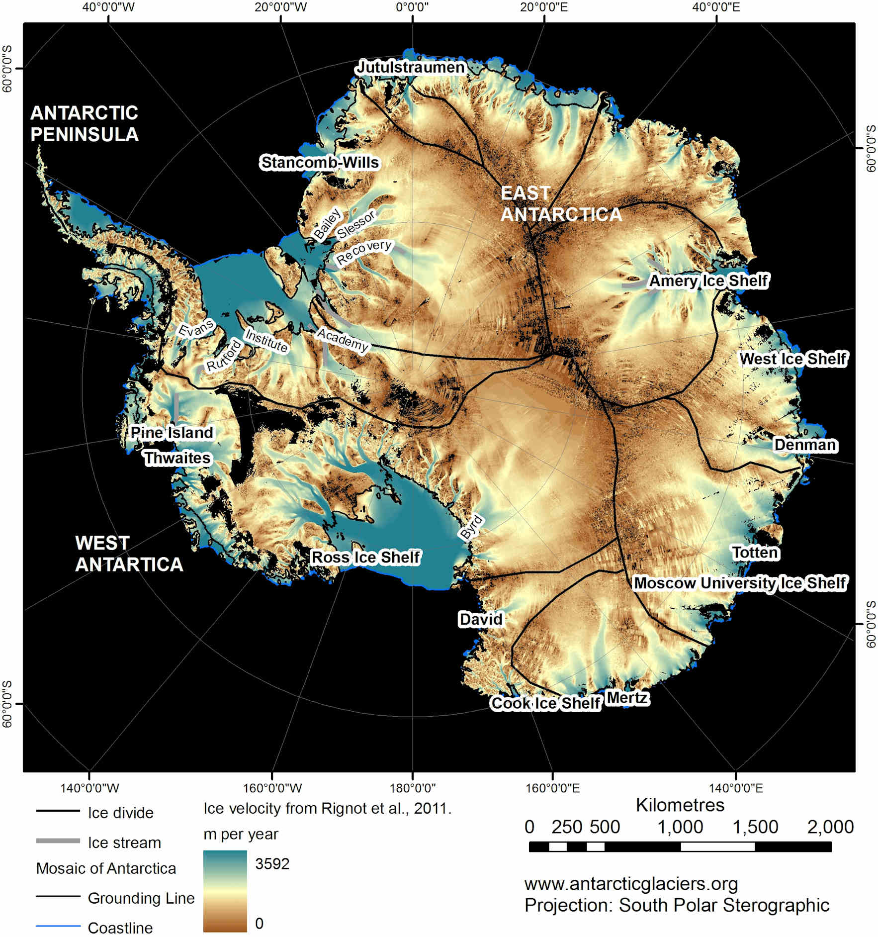
(Antarctica glacial velocity map composed by Eric Rignot in 2011. Blue = fast. Brown = slow. Note the numerous high-speed glacial flows plunging deep into Antarctica. By the 2010s, Antarctica was losing between 1,300 and 2,000 gigatons of ice each year. Image credit: Antarcticaglaciers.org.)
A Glimpse into Earth’s Past Provides Stark Evidence For a Human-Warmed Future
The study, entitled Millennial-Scale Variability in Antarctic Ice Sheet Discharge During the Last Deglaciation, and published in Nature, took a closer look at Antarctic ice sheet instability and its contribution to sea level rise during the end of the last ice age by taking sediment cores from iceberg rafted debris (IBRD) fields around the frozen continent. These fields contained minerals left by melting glaciers discharged into the Southern Ocean during the major glacial melt events at the end of the last ice age and provide a good proxy for the rate of glacial discharge from Antarctica.
Analysis of these sediment cores resulted in the finding that Antarctica experienced 8 separate large glacial outburst events during the end of the last ice age. These events began about 20,000 years ago and ended 9,000 years ago. This is directly counter to conventional thinking that had assumed Antarctic melt started late and ended early during the last glacial melt period. It also hints that the Antarctic ice sheet is far less stable that previously assumed, making it much more vulnerable to current, human-caused heat forcings.
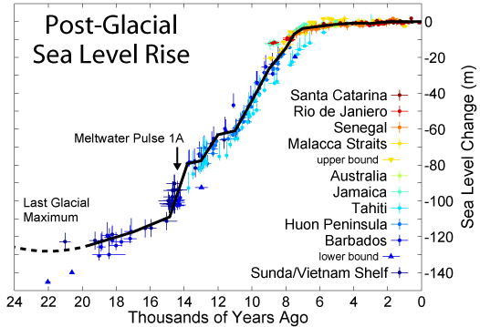
Each large outburst event contributed significantly to global sea level rise. The largest and most violent event was found to have occurred around 14,900 years ago. Lasting 350 years, this single episode, known as meltwater pulse 1A, resulted in a 50 foot sea level rise, pushing global oceans higher by 14.2 feet per century. It was previously unknown that Antarctica contributed in any way to this rapid sea rise event. But large deposits of iceberg sediment during this time of surging oceans provides strong evidence that Antarctica was a major contributor.
(Pace of post glacial sea level rise since the end of the last ice age. Note the steep rise in sea levels occurring in conjunction with meltwater pulse 1A, a pulse that scientists now know included a major contribution from Antarctic melt. Image source: Commons.)
Professor Clark of Oregon State’s College of Earth, Ocean and Atmospheric Sciences who contributed to the paper noted:
“During that time, the sea level on a global basis rose about 50 feet in just 350 years – or about 20 times faster than sea level rise over the last century. We don’t yet know what triggered these eight episodes or pulses, but it appears that once the melting of the ice sheet began it was amplified by physical processes.”
Implications for Current-Day Human Warming
At first blush, the findings of this study may seem innocuous. But upon reflection, one quickly comes to the conclusion that they are rather stark.
In total, about 200 feet of potential sea level rise is currently locked in all of Antarctica’s ice. This compares to Greenland which, if it completely melted, would contribute about 24 feet to sea level rise. Until recently, it was assumed that this large store of ice in Antarctica was relatively stable and responded only slowly to climate perturbations.
The first challenge to the notion of Antarctic ice sheet stability came in 1968 when glaciologists began issuing warnings that the West Antarctic Ice Sheet was unstable. But, until recent years, this instability lacked an observed physical mechanism to explain what appeared to be an ongoing and increasingly rapid glacial rush toward the sea. By the mid 2000s, scientific reports began to emerge showing that warm water upwelling along the coasts of Antarctica was eating away larger and larger chunks of the great glaciers’ bases and speeding their flow to the sea. This year, a flurry of reports sounded a death knell for entire sections of West Antarctic ice, locking in many feet of sea level rise with more likely to come.
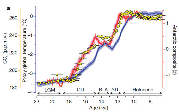
(Temperature and CO2 increase from 22,000 YBP through 6,000 YBP. Note that major glacial outburst events in Antarctica began after only .2 C of atmospheric warming and 10 ppm of CO2 increase around 20,000 years ago. Such a response shows a very high degree of glacial and Earth Systems climate sensitivity. Also note that total warming over a 12,000 year timeframe was 3.7 C. Warming of 4, 6 and even 9 C is possible by the end of this Century under BAU human greenhouse gas forcing. Image source: Nature via Skeptical Science.)
But until this recent Nature paper, such a rapid destabilization of Antarctica’s massive glaciers was without a paleoclimate context. For few studies had challenged an assumed but sparsely supported perception of past Antarctic ice sheet stability. To the contrary, the paper found an Antarctic ice sheet that was very sensitive to warming. The ice sheet issued its first major glacial outburst 20,000 years ago as the world showed its first hint of thaw from a great ice age. The giant glaciers continued their lashing out in 8 major events until warming stopped with the advent of the Holocene around 9,000 years ago. At that point, Earth’s climate had begun to settle into a new equilibrium and Antarctica quieted its grumbling.
Now that humans are warming the atmosphere and oceans at a pace at least 30 times that of the last ice age, we are discovering that Antarctica in the deep past showed a major destabilization response to even the slightest hint of warming.
A Warming Ocean is Likely Antarctica’s Soft Underbelly
Rapidly accumulating evidence that ocean warming is providing a powerful blow to the world’s glaciers combines with the recent study to provide a stark implication — any addition to atmospheric heat is rapidly transferred to the world’s oceans which, in turn, goes to work melting ocean-contacting glaciers. Furthermore, glacial destabilization is likely to remain in play so long as the global energy imbalance toward continued warming remains in force and destabilized glaciers haven’t yet hit the ocean. As such, we should consider that start time for glacial destabilization and increasing rates of sea level rise to be now and not in some distant, far off, future.
Glacial systems may well present considerable atmospheric inertia. But when presented with warming waters, the glaciers must yield. This makes sense as water’s heat capacity is four times greater than that of air. So the melting force of water just one degree C above freezing is about four times that of the same volume of air at the same temperature. Glaciers in constant contact with the potent heat capacity of warming oceans essentially don’t stand a chance. And with many of Antarctica’s glaciers directly in the firing line of waters warmed by human greenhouse gas forcing rising from the deep ocean, it would appear, at this time, that the great frozen continent may well have a very soft underbelly.
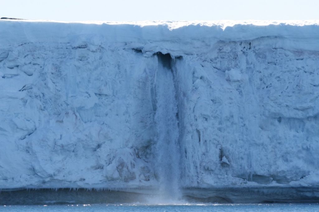
(Waterfall spilling from the heart of a melting Antarctic glacier and into the Southern Ocean. Image source: Antarctica.gov.au)
Inertia Not So Strong as the Forcing; Stark Implications For Sea Level Rise
Since so much has happened over the past year, it is useful to put the current state of science into an overall context. In doing so we should consider these scientific findings:
Large portions of Antarctica are already undergoing destabilization or irreversible collapse.
In the deep past, Antarctica responded very rapidly to even a small global temperature change and remained unstable so long as warming continued.
This rapid glacial response and destabilization was likely due to a broad basal exposure to warming oceans.
The current pace of human warming is now 30 times faster than at the end of the last ice age.
The deep ocean is accumulating heat faster than any other Earth System.
At peak, the most violent glacial outburst flood events included glacial discharges from Antarctica and pushed sea levels higher by 14.2 feet each century during the end of the last ice age.
Current human CO2 heat forcing at 400 ppm + is enough to raise sea levels by 75 feet according to paleoclimate estimates.
Current human CO2e heat forcing at 481 ppm + is enough to raise sea levels by 120 feet according to paleoclimate estimates.
Considered together, these points would seem to indicate that glacial inertia to heat forcing is not so great as previously hoped. More likely, the energy balance of the Earth System more rapidly responds to total heat content, energy imbalance, and pace of heat accumulation than previous sensitivity estimates assumed. If this meta-analysis is true, and it seems to be based on a growing pile of evidence, sea level rise for the current century is likely to be far greater than previously anticipated by scientific assessments. The top range of a 3 foot sea level rise for this century under IPCC modeling is likely, given current realities, to instead be a low estimate. A more realistic range, given a greatly reduced true glacial inertia, is probably 3-9 feet through 2100 with higher outside potentials during large glacial outburst flood events.
Given changing ocean and atmospheric conditions together with the rising potential of large rainfalls over certain glacial zones during summer as the 21rst century progresses, climate analysts should consider such large glacial outburst floods to be a potential high risk event under current extreme human warming. It is also worth noting that these glacial systems have probably never experienced a set of forces so powerful or rapid as they are likely to face as the 21rst century progresses. Recent scientific assessments are essentially playing catch-up to these new and emerging realities.
Major melt in the midst of winter. Doesn’t sound quite right, does it? We tend to think of winter as the time of freezing, as the time of ice accumulation. Not the time of melt and thaw.
Now try this — major melt in Alaska in the midst of winter. Average temperatures 40 degrees hotter than normal in the midst of winter. Rainfall over snow and ice causing avalanches, major road blockages and ice dams to rivers in the midst of winter.
In this instance we have been transported from the somewhat odd into a reality that is completely outside of our previously ‘normal’ context. In this instance we are transported to a time that may well seem like the beginning of the end of the age of ice on planet Earth.
And yet this is exactly what is happening: one of the coldest regions on the planet is experiencing melt and related record heat in January.
For the state of Alaska, the consequences are a strange and freakish winter heat wave, one that features the extreme temperatures mentioned above. For the city of Valdez, as we shall see below, the situation is far more stark.
(Massive Avalanche set off by rainfall, winter warmth, cutting off Richardson Highway to Valdez Alaska and forming a dangerous ice dam of the ironically named Keystone Canyon’s Lowe River. Image source: Alaska Department of Transportation and Public Facilities.)
Hottest ever Winter-time Temperatures for Alaska
On Sunday, a collapse event that flooded the Arctic with heat and ripped the polar vortex in half began. A freakish high amplitude ridge in the Jet Stream that had been pumping warmth over Alaska and into the Arctic for ten months running strengthened. The result was that many regions throughout the state experienced their hottest temperatures ever recorded for that day, month, or season.
(Global Temperature Anomaly Data vs 1979-2000 mean with focus on Arctic for January 29. Note the extreme Arctic deviation of +5.58 degrees Celsius and the pool of 36+ F high temperature deviations still lingering over Alaska. Also note that global anomalies are +.32 C above the 1979-2000 mean which is, itself, about +.5 C above average temperatures during the 1880s, for a total of about +.82 globally. The above measure is an excellent illustration of both extreme polar amplification and very rapid warming coinciding with a strong negative Arctic Oscillation, related warm air influx, and polar vortex separation. Source: Climate Change Institute.)
According to reports from Weather Underground, Homer Alaska, for example, experienced an all time record high for the day of 55 degrees Fahrenheit, 4 degrees hotter than the previous all-time high set just a few years earlier. And Homer was just one of the many cities sitting in a broad region of extraordinary, 40 degree hotter than normal temperatures. A region extending from the interior to the southern and western coasts. Bolio Lake Range, about 100 miles south of Fairbanks in central Alaska, saw temperatures rocket to 60 degrees, just 2 degrees short of the all-time record high for any part of the state during January (the previous record high of 62 was set in Petersburg, nearly 700 miles to the south and east).
Typically colder high mountain regions also experienced record warmth for the day. A zone 10,600 feet above Fairbanks hit 32 degrees Fahrenheit on Sunday, the highest temperature ever measured for this region during any winter-time period from November through February.
Even before the most recent extreme Arctic temperature spike, January saw numerous powerful heat influxes for Alaska with Nome, Denali Park, Palmer, Homer, Alyseka, Seward, and Talkeetna each setting all-time record high temperatures during the month.
These records come on the back of a long period of rapidly increasing Alaskan heat stretching all the way back to the 1970s. In many cases, we are seeing all-time record highs broken with 5-10 year frequency. In the most extreme cases, these records fall again after only standing for 1-5 years.
Taken in this context, what we are seeing is the freakish continuation of an ongoing period of inexorable Arctic warming providing yet one more major insult to the Alaskan climate during the winter of 2013-2014.
Rain and Melt Sets off Major, Spring-like, Outflows From Streams and Rivers
The same anomalous Jet Stream pattern that has acted as a conveyer belt continuously transporting heat into the high north over Alaska has brought with it an almost endless series of rain events to coastal Alaska. Storm after storm, fueled by heat and high rates of evaporation over the northern Pacific, slammed into the Alaskan coastline, disgorging record levels of precipitation.
With temperatures freakishly high, mirroring conditions typically present during late spring or early summer, much of this precipitation fell in the form of rain. Valdez, Alaska, for example, has likely experienced its wettest January ever with rainfall measures just 1.35 inches short of the record on Sunday and a series of strong storms rushing into the city on Monday and Tuesday. Given the nearly endless train of storms lining up to sweep over Valdez, it is possible that its previous record of 15.18 inches for January could easily be surpassed by an inch or two at month-end.
The storms and cloudiness make it difficult to peer down and get a good view of what all this heat and rainfall is doing to the Alaskan snow and ice pack. But, for brief respite, on January 25th, just ahead of the most recent influx of rain and warmth, the clouds cleared, revealing the land and sea surface. And what we witness is extraordinary:
(Southern Coast of Alaska with major sediment outflow from snow and ice melt, record heat and rainfall in January 2014. Image source: Lance-Modis)
The entire southern coast of Alaska from Prince William Sound to Cook Inlet are visibly experiencing major snow and ice melt along with flooded streams and rivers flushing out a massive volume of sediment into the Gulf Alaska. Clearly visible in the satellite shot, the sediment now streaming into the ocean is more reminiscent of a major late spring flood event than anything that should be ongoing for Alaska in the midst of winter.
Yet here we are. A situation of continuous, never-before seen heat for Alaska during winter time bringing on a flooding thaw that is far, far too early.
Rainfall over Glaciers, Snow Pack Triggers Massive Avalanche that Cuts off Valdez
The constant assault of heat and record temperatures combined with an almost endless flow of moisture riding up from the Gulf of Alaska set off a devastating and freakish event near Valdez on Saturday. Severe and record rainfall over the mountain regions have continuously softened glacial ice and snow packs above this major Alaskan city. On Monday, the continuous insults of heat and water passed a critical threshold.
As the warm water filtered down through the colder snow and ice, the anchoring base was lubricated even as the capping snow grew heavily burdened with water. Eventually, the insults of heat and rainfall became too great and a major snow and ice slope system above the main road linking Valdez to mainland Alaska collapsed. The immense volume of snow and ice unleashed, spilling down to fill the base of Keystone Canyon, blocking both the Lowe River and the Richardson Highway running through it.
This snow and ice dam rose as high as 100 feet above the Canyon floor, causing the Lowe River to rapidly flood, inundating the already snow-and ice buried road under an expanding pool 20 to 25 feet deep and filled with ice-choked water.
You can see the massive avalanche-created ice dam and related road inundation in the video provided by akiwiguy below:
In the context of our present extreme Jet Stream pattern that is setting off warmest-ever conditions for Alaska during January together with dangerous melt-outburst related events while at the same time periodically flushing Arctic air and extreme winter weather south into the United States, it is important to remember a few things. The first is that the Arctic is now experiencing never-before observed warmth with stunning frequency. Scientific papers now show that the Arctic is hotter than it has been for at least 44,000 years and possibly 120,000 years.
By comparison, the cold snaps, that could very well be seen as the death gasps of the Arctic we know, impacting the eastern US are relatively minor when put into this larger, more ominous context. Similar cold events were last seen about 20 years ago in the US. And so there is simply no comparison that can generate a rational equivalency between the, hottest in an age, Arctic temperatures and the, coldest in a few handfuls of years, temperatures in the Eastern US.
And if you’re one of those sensitive, perceptive souls who feels that the weather events you’re seeing, the extreme swings from very hot to somewhat cool temperatures, the extreme swings from drought to record rainfall, and the extreme events now accelerating the melting of the world’s ice and snow, are freakish, strange, and terrifyingly abnormal, then you are absolutely correct. Don’t let anyone, be they friends or family, or journalists in the media, tell you otherwise. There is reason for your discomfort and there is very serious cause for concern.
It’s been yet one more summer of anomalous weather events resulting from human-caused warming. Massive floods have spanned the globe, shattering records that have stood for 50, 100, or even 500 years. In other regions, record droughts and heatwaves have resulted in thousands of heat injuries and hundreds of deaths with the southeast Asian heat dome alone reported to have hospitalized tens of thousands and resulted in at least 100 deaths in China, Japan and Korea. These droughts and heatwaves created hazardous water shortages putting communities from the American Southwest to Eastern China at risk of severe damage and loss of ability to supply growing water demands. They also sparked massive and freakish wildfire complexes that damaged or destroyed hundreds of buildings or left enormous burn scars over landscapes from tropical regions to the Arctic tundra — some of which have now born the excessive insults of major fires for ten years running. The term Arctic heatwave has become common parlance. And the combination of extreme weather has resulted in widespread damage to crops and related livestock industries.
All these extreme events, in concert, are visible proofs of a climate emergency that is just starting to ramp up. Few have received the attention they warrant in the mainstream press — either singly, or together as an overall dangerous alteration to the world’s climate and weather.
But of all these, rather ominous, events, one stands out as a warning of a new, out of context, threat — a set of freakish floods in the Himalayan highlands. Floods set off by a combination of high altitude rainfall and the collapse of damns formed around growing glacial melt lakes in a region undergoing very rapid melt and warming.
(Aftermath of Glacial Outburst Flood at Kedarnath, India)
Glacial Outburst Flooding in Kedarnath
Since the early 2000s, average temperatures in the Himalayan Mountains in northern India have increased by about 1 degree Celsius, around 4 times the global average. This steady temperature rise has resulted in a gradually increasing melt of the massive glaciers along this major mountain chain featuring the tallest peaks in the world.
Over the past decade, immense glaciers along this range have witnessed unprecedented melt with many glaciers losing up to 30% of their mass. Predictions show total melt for most glaciers likely to occur under current rates of warming and fossil fuel emission by around the end of this century. The massive and unprecedented rate of melt has fueled the formation of numerous very large and growing glacial melt lakes throughout the Himalayan region. So far, about 200 of these amazing 20,000 melt lakes have outburst in flood events that are a direct result of human caused warming and related glacial melt in the Himalayas.
One such melt lake developed and filled over the past few years in a region just 4 kilometers to the north of the Indian village of Kedarnath. It was just one of the hundreds of newly formed lakes that developed and steadily grew in size over the past five years. By June of 2013, the lake had filled to capacity. Its high altitude waters held back only by a thin damn of sediment pushed out by the now, mostly melted, glacier. Then came the rains.
In the days leading up to June 17, a massive rainfall event inundated the Kedarnath region, spilling waters into an already over-filled glacial melt lake north of Kedarnath. By June 17, a tipping point was reached and the sediment damn holding back the brimming glacial melt waters erupted, unleashing what amounted to a mountain tidal wave upon Kedarnath and a massive area stretching 40 miles downstream from the glacial outburst.
This immense flood swept away more than 6,000 people who are now presumed dead after one of the worst flood events in Indian history, an event that would almost certainly have never happened without human-caused warming.
“The Kedarnath floods may be only a small precursor to never-seen-before mega floods,” says Maharaj K. Pandit, director, Centre for Inter-disciplinary Studies of Mountain & Hill Environment, Delhi University. Scientists like him believe that the high precipitation on June 16 rapidly filled up Chorabari Tal, a glacial lake less than 4 km upstream from Kedarnath, and the continuing downpour the next morning caused the lake to overflow and possibly burst out from its loosely packed rim of moraines (glacial sediments).
Increasing Rainfall Over Himalayan Glaciers and Growing Risk of Megafloods
According to reports by Indian scientists, rainfall rates over the Himalayan mountain chain are increasing even as rates of snowfall events are falling. Overall, precipitation is increasing by 30 percent, but more and more of this greater volume of precipitation is coming down as rain. The rain provides a double stress to glaciers in that it delivers more heat to already rapidly melting ice masses and the added run-off creates large pulses that both erode ice sheets and sediment deposits that keep both ice and water locked in. Eventually, water erosion and heat stress is too great, melt rates are too high and sediment and ice damns can no longer hold. The result is a massive and very dangerous flood event called a Glacial Outburst Flood (GLOF).
The Himalayans have seen increasingly severe GLOFS since 1929 when the first major such event emerged. Overall, 200 GLOFS have inundated various regions surrounding the Himalayans with major resultant damage to infrastructure and loss of human life. But with hundreds of new lakes forming over the past five years and with rates of glacial melt spiking, the risk for increasingly catastrophic GLOFS is growing.
As noted above, there are currently 20,000 large melt lakes throughout the Himalayan chain and, with temperatures in the region expected to increase by another 1-2 degrees Celsius before 2050, the number and size of glacial melt lakes is bound to grow. More rainfall will occur at higher and higher elevations, pushing glacial melt lake levels higher and higher. In the end, millions of downstream residents are at increasing risk of Glacial Outburst Floods.
With human climate change pushing warming at such a rapid and unprecedented rate, it is only a matter of time before more of these amazingly dangerous events take place. Global carbon emissions hit a new high in 2012 and a start to global greenhouse gas reductions, without serious and immediate global policy measures, is years to decades away. So it is highly likely that risks for large GLOFS will continue to increase in India and in other nations bordering the Himalayan mountain chain.
Stark Implications for Greenland, West Antarctica
Anywhere in the world where major ice sheets and glaciers exist, the threat of large Glacial Outburst Floods is growing. Perhaps the starkest manifestation of this risk is visible upon the now, rapidly melting, ice sheet of Greenland.
But with very rapid melt starting to occur now, it is likely that we are already at the point of large-scale destabilization of the Greenland ice sheet even as we stare down the face of setting in place a total melt scenario over the next few decades (setting off a chain of chaotic events that would likely take centuries to complete). With temperatures continuing to rise over Greenland and with human greenhouse gas forcing and Earth System feedbacks also on the increase, it is highly likely that pace of ice sheet destabilization will continue to accelerate.
The problem with Greenland melt, however, is in many ways far worse than the melt of the massive, though comparatively smaller, Himalayan Glaciers. The Greenland ice sheet is entirely contiguous and has massive depth and a towering elevation of two miles at its center. Glacial Outburst Flood events from such a large source will, therefore, be far, far more catastrophic.
In the Greenland melt dynamic, multiple glacial melt lakes will increasingly form over the surface of the Greenland ice sheet. We can already see such events beginning during current summers. The above shot provided by NASA shows numerous melt lakes forming in the western border of the Greenland Ice Sheet on August 4 of 2013. These melt lakes are many times larger than those seen in the Himalayas with some of them stretching six kilometers in length. In the future, we can expect the size and number of the glacial melt lakes to greatly increase.
Risk of a Greenland Megaflood Arises
With such a large region of ice covered by numerous melt lakes, a kind of ominous tipping point may be reached. During warm summer months, weather systems may pull warmth and moisture over a large section of the Greenland Ice Sheet which is already covered with numerous melt ponds. Temperatures above freezing and a constant flow of moisture emerging from the southern latitudes through a locked in place Jet Stream pattern may ensure that the rain event over these Greenland melt lakes lasts for days or weeks.
Eventually, some of these melt lakes begin to over-top, spilling waters into the already filled lakes lower down on the ice sheet. These lakes then also over-top, contributing ever greater volumes of water to the growing flood.
Depending on how far melt lakes penetrate into the ice sheet, this chain reaction over-topping can proceed for tens or even hundreds of kilometers. By the time the massive flood has reached the lower ice sheet edge, perhaps a kilometer or more below the initial flood source, a massive glacier-originating wave has developed, one that is, perhaps, tens or hundreds of feet in height and with a front covering tens or even hundreds of miles.
Such a powerful outburst megaflood would contain both freezing water and large fragments of ice ripped from the ice sheet as the outburst wave proceeded down the ice sheet. And, like the Kedarnath megaflood, it will also likely contain boulders pulled from adjacent mountains and lands. But this particular event would be far, far worse than any Himalayan outburst flood. It would proceed for hundreds and, perhaps, thousands of miles from the outburst site, leaving a swath of destruction similar to that seen in the worst global ocean tsunami events of recent years.
Melt Lakes Forming Among Terrace-Like Structures on the Greenland Ice Sheet. Set up for Future Large Outburst Megaflood?
We see evidence of such events occurring at the end of the last ice age, with petrified trees imbedded in rock strata up to 500 feet above sea level in the cliffs and mountainsides of Pacific Islands bordering the Arctic. It is thought that these trees were carried by massive glacial outburst floods from the melting Laurentide Ice Sheet which, at the end of the last Ice Age, was thousands of miles away from this tree deposition. The trees found in these deposits are natives to Canada and Alaska and the character of their deposition is indicative of a catastrophic outburst flood event or series of events.
Glacial Outburst Megafloods are among the most dangerous risks posed by rapid Greenland and West Antarctic Ice Sheet melting, warming and destabilization. And Greenland is most likely to see its first manifestations, though Antarctica may follow soon after, over the course of years or decades. Such ice sheet decline will be both chaotic and destructive — with moments of almost unthinkable outburst events proceeding once certain tipping points are reached. Some of these events may already be locked in due to current human forcing and related natural feedbacks. Let us hope that it is possible to prevent their very worst manifestations.
Greenland Outburst Flood of 2012 to be Seen as Minor by Comparison
Should such events occur, a massive outflow of water near the Greenland Ice Sheet during 2012 that washed out a bridge and threatened a local airport will be seen as minor. For comparison, I’ve added the following video:
A major outburst flood issuing from a large section of the Greenland ice sheet would render miniscule even this, very energetic event.


