
In Borrego Springs, CA at 10 AM this morning, the temperature was a scorching 116 degrees F. Temperatures today are expected to hit 122 degrees F (50 degrees C) for this California location — which would tie the all-time high for any date there. But it’s just a microcosm of the record-shattering heat that is now settling in over the US West. Heat that looks like it will remain in place for days and possibly weeks. Heat that is now resulting in tragic instances of loss of life even as it is sparking numerous massive widlfires, melting snowpacks, worsening droughts, and otherwise sparking conditions that are related to a human-forced heating of the globe.
****
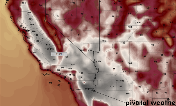
In Glendale, a suburb of Phoenix, temperatures rocketed to 120 degrees Fahrenheit (49 C or 14 degrees F above average) as numerous locales recorded temperatures well in excess of 120 throughout the region (see map below). Tuscon hit 115 (46 C or 15 F above average) and Phoenix soared to 118 (48 C or 15 degrees F above average). California saw its own spate of record heat with Los Angeles soaring to 96 F (36 C which is 23 F above average), Burbank hitting 109 F (43 C and also 23 F above average), Riverside seeing 111 F readings (44 C and 19 F above average) and Thermal rising all the way to 119 F (48 C and 13 F above average). Seven communities in New Mexico also saw record hot readings for the day.

(Sections of Phoenix scorched on Sunday with this Google Map from Ben Newmann showing some areas experiencing 127 degree F [or 53 C] readings. Image source: Google Maps via Ben Newmann.)
The record heat resulted in 4 separate incidents of hiker deaths as rescue personnel responded to trail-goers suffering from heat injuries Sunday. Two of the fatalities occurred along trails near Tuscon while another pair of fatalities cropped up just outside of Phoenix. A fifth hiker is now also reported missing.
Today, the extreme heat is predicted to make a repeat comeback as readings are expected to hit or exceed 121 F in some regions. Meanwhile, Tuesday is expected to be even hotter.
Thousands of Firefighters Battling Blazes
As heat expanded beneath a sprawling dome of high pressure, groups of firefighters the size of small armies battled numerous blazes.
In Los Angeles 2,000 firefighters and 23 aircraft were engaged with the Sherpa Fire raging through the Santa Barbara region. By late Sunday, nearly 8,000 acres had burned (12 square miles), a section of a water treatment plant was consumed, and the fire was 54 percent contained. However, 55 mph winds overnight and temperatures rising to or near triple digit heat today were expected to give those fighting the blaze a grueling challenge.
Near Albuquerque, the Dog Head fire had consumed fully 18,000 acres and was only 9 percent contained by late Sunday evening. The swift moving and raging fire had damaged or consumed 45 structures by that time as 1,000 firefighters fought to contain it. Continued extreme heat in the region through at least Tuesday is expected to make fighting the blaze a very difficult prospect over the next two days.

(Cedar Creek Fire grows in size as it changes direction late Sunday. Image source: Chris Gross.)
North of Phoenix, the Cedar Creek Fire had swelled to 26,000 acres Monday, cut off route 60, and jumped the containment line. A shift in the wind caused the fire to dramatically alter course Sunday night — outflanking firefighting efforts in the process. The blaze had been 40 percent contained as of late Sunday, but these estimates will have to be revised downward. The fire is now threatening the town of Carrizo — which is expected to receive evacuation orders later today.
Conditions in Context
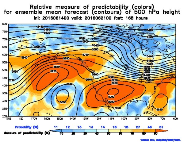
Fueling both the extreme heat and wildfire outbreaks across the Western US are conditions consistent with human-caused climate change. Very strong high pressure ridges dominate both the ocean zones of the Northeastern Pacific and the North Atlantic. These high pressure systems are both more powerful and extend further north than is typical. In addition, water temperatures both off the Eastern Seaboard and off the US West Coast are much warmer than normal. These features have all fed the development of a powerful heat dome high pressure system that is now forming over the US.

(Ten day forecast shows an extremely powerful ridge in the Jet Stream extending all the way into the Arctic as an associated heat dome swells beneath. This kind of system threatens to propel 90 degree heat all the way to the shores of the Arctic Ocean over the next two weeks. To be very clear, these conditions are not normal. They represent an extreme south to north transfer of heat that threatens to deliver a brutal blow, not only to the US and Canada, but also to the Arctic itself. Image source: NOAA NCEP via Zack Labe.)
Over the coming days, this ridge is expected to swell and strengthen as it drives the Jet Stream far north over Canada and into the Arctic. There, sea ice extents continue to range in record lows for this time of year — lending power to the forming ridge and the heatwave inducing dome high pressure system developing underneath. As a result, we will likely continue to see fire hazards spike throughout the Central and Western US, we will likely continue to see record or near record heat, and we will likely see a re-expansion of drought conditions in the US West.
In addition, this heat dome is so powerful and has such a strong predicted northward extent that temperatures in the 80s or even 90s may extend as far north as the shores of the Arctic Ocean in Canada and Alaska. So wildfire and heatwave risks will be moving north into Arctic regions over the coming days as well.
Links:
Heatwave Scorching the Southwest Proves Fatal
National Interagency Fire Center
Sherpa Fire 51 Percent Contained
Wildfires Burn as Southwest Swelters Under Triple-Digit Heat
Hat tip to DT Lange
Hat tip to Colorado Bob
Hat tip to Andy in San Diego
Hat tip to Caroline


