Alaska’s Epic 2015 Burning is One Month Ahead of Previous Worst Year; Canada Conflagration Continues, Eastern Siberia Wildfires Light Off

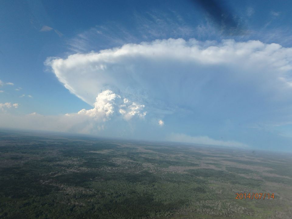
From Canada to Alaska to Siberia, an immense half-crescent of the Arctic is on fire. The hot spots along this zone include freakish fires with 50 mile fronts, fires that generate thunderstorms from the heat of their updrafts, and fires that paint smokescapes over the lake waters of Canada even as they light the sky red:

(Freakish lake fire burns in Saskatchewan, Canada on Monday, July 13. It’s just one of thousands of fires now raging through Arctic lands and 5,105 fires burning through Canada alone.)

Fires, overall, that have been vastly under-reported in the mainstream media. And, even when they are reported, they include often inaccurate qualifiers.

So what the heck is really going on? The human hothouse is generating an ever-greater burning potential throughout the Arctic. One that has erupted toward new levels of intensity this year. One that is plainly and painfully visible to any who care to look.

*   *   *   *   *

In Alaska, a massive area the size of one and one half Connecticuts (7,300 square miles) has already been consumed by fires. A zone of smoldering tundra, boreal forests turned to ash, smoking bogs, and smoldering, thawing permafrost.

But aside from a handful of responsible sources (see also here), the mainstream media just can’t get what is now likely to be the worst fire season ever to strike Alaska right. So let’s take a few moments to set the record straight on what is an unprecedented burning of Alaska’s warming tundra, forests and permafrost. A burning that is related to human greenhouse gas emissions-based heating of the atmosphere in that the thawing permafrost provides additional understory and methane fuels to fires even as it multiplies the number of fire-igniting lightning strikes.

A Failure to Accurately Report on an Ongoing Disaster Directly Linked to Humanity’s Greenhouse Gas Emissions

At first, a sudden, abnormal outbreak of hundreds of wildfires throughout the Arctic state during June was framed ‘not abnormal.’ That is until June shattered all previous records for worst wildfires ever and put all notions that anything normal was going on soundly to bed.

Next, the narrative ran on the false meme that most of the fires were caused by human hands (of the match tossing variety). Any journalist worth their salt, however, could simply check that pseudo factoid against the Alaska Interagency Coordination Center report to find that 377 fires were lightning-caused (well more than half) and that these lightning-caused fires, as of Tuesday, amounted to a whopping 4,675,000 acres burned. The human match, lighter, and campfire ignited fires? A piddly 30,000 acres. In other words, more than 99 percent of all the area burned was due to a warming-intensified proliferation of thunderstorm activity and related lightning strikes.

Alaska Pyrocumulous Clouds

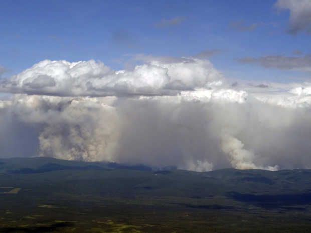
(Pyrocumulus clouds have been popping up like hothouse amplifying daisies all over Alaska since mid June. This ridge fire appears to be in the process of building its own thunderstorm. Image source: ADN.)

Indirectly, we could certainly call this extra lightning human-caused — as the vehicle of greenhouse gas warming has resulted in a marked increase in lightning strikes to the thawing permafrost and heating forest and tundra fuels. But this particular human cause is certainly not of the typical match-throwing, arsonist variety. It’s another story entirely. A much more important story that far too many sources appear to be (unintentionally or deliberately) missing. A story of the plainly visible and worsening impacts of human-forced climate change.

To use any set of language other than to characterize the Alaska burning as unprecedented, freakish, record, and abnormal is vastly irresponsible. Any attempt to attribute the 4,675,000 acres ignited by warming induced lightning strikes to ‘arson’ is equally myopic and misleading. If you’re reading a source that makes these claims, that source is an invalid and untrustworthy reporting medium. One that can’t keep a handle on even the most basic of facts.

Alaska Burning is One Month Ahead of the Worst Fire Year Ever

And when all the dust of this mass misinformation over a critical issue directly related to human-caused climate change settles, we find that Alaska’s fires are now burning at a rate fully one month ahead of the previous all time record fire year of 2004. Tuesday’s total acres burned of 4,705,000 stood but 1,900,000 acres shy of that record. And at the current rate of burning, that total could be consumed within a mere 7-15 days — putting the current Alaska wildfire season, by late July or early August, at new record thresholds with more than a month left for forests, tundra and permafrost to continue to burn.

Alaska Wildfires July 14

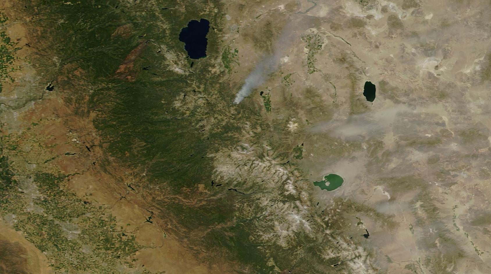
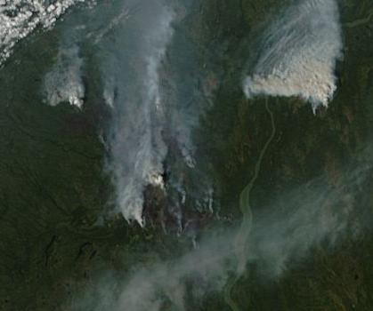
(Hundreds mile long smoke plumes issuing from Wildfires in Alaska on July 14. Image source: LANCE-MODIS)

In the July 14 MODIS satellite shot we can clearly see massive smoke plumes billowing up from the still energetically burning fires in Central Alaska. Lightning laden cumulonimbus clouds ride overhead — a pattern refreshed by a continuous influx of warm storm moisture rising up over the Gulf of Alaska and deflected off the ridiculously resilient ridge (RRR) to the south. The storms are still setting off around 3-7 fires each day. A rate of new ignition that, though slower than June, is pushing total number of Alaska fires toward the unprecedented 700 line.

7.5 Million Acres Burn in Canada

Across the border in Canada a whopping 5,105 fires are now also consuming vast stretches of Arctic land. It’s an outbreak that resulted in the largest natural disaster evacuation in the history of Saskatchewan. One that has drawn firefighters from all over the world to combat an immense proliferation of blazes. Blazes that have burned about 7.45 million acres so far or an area about the size of 2.3 Connecticuts.

When combined with the Alaska fires, the total area now burned in Arctic sections of North America now equals about 12.1 million acres or more than 1 million acres burned since this time last week. Rates of burning for Canada are, like Alaska, in many cases unprecedented. Total acres burned for the Arctic nation are now at two times the five year average and three times the 25 year average. Specific regions, like British Columbia, are seeing as much as 10 to 20 times the typical area burned by mid July.

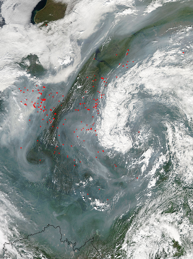
Vast Wildfire Eruption in Eastern Siberia

Moving on across the rapidly thinning ice of the Beaufort, Chukchi and East Siberian seas, we find that Eastern Siberia is also experiencing a massive wildfire outbreak. Reports from Russia on acres burned have tended to be spotty. But this zone near Lake Baikal has seen a persistent and then an expanding propagation of burn zones toward the north and east since April.

Vast burning in Eastern Siberia

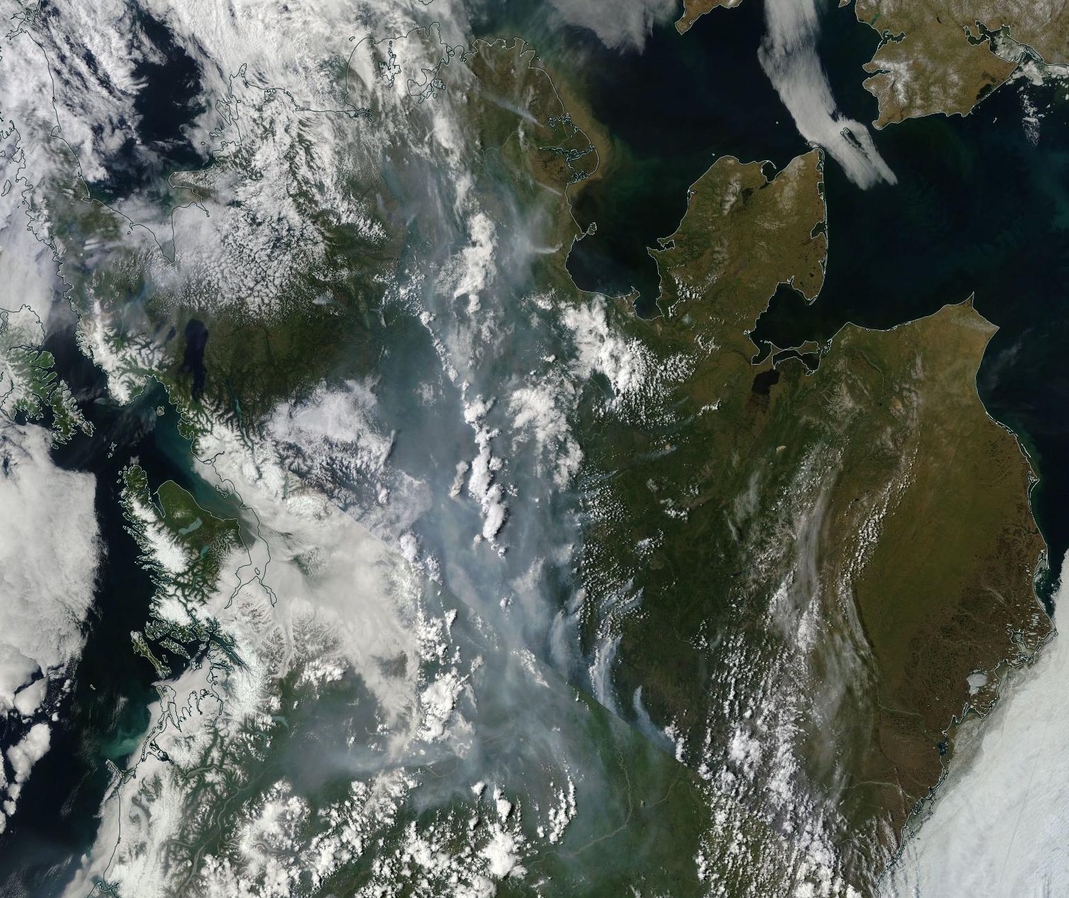
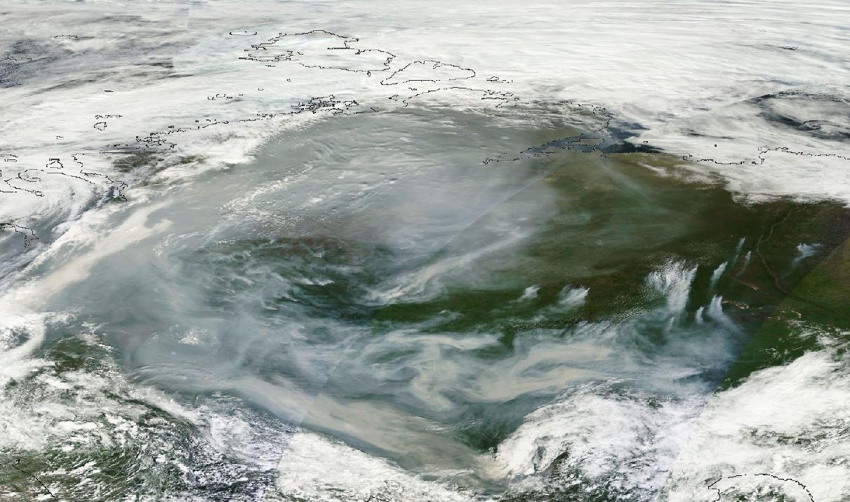
(Vast swath burns through Eastern Siberia on Wednesday. Image source: LANCE-MODIS).

Today, the fire outbreak there could best be described as vast. Stretching from Lake Baikal to the Sea of Okhotsk, the fire zone now encompasses a region more than 1,000 miles across. Scores of large fires can be seen burning beneath a massive cloud of smoke that streams all the way down through China, combining with the nasty coal dust cloud stooping over that fossil fuel victimized state.

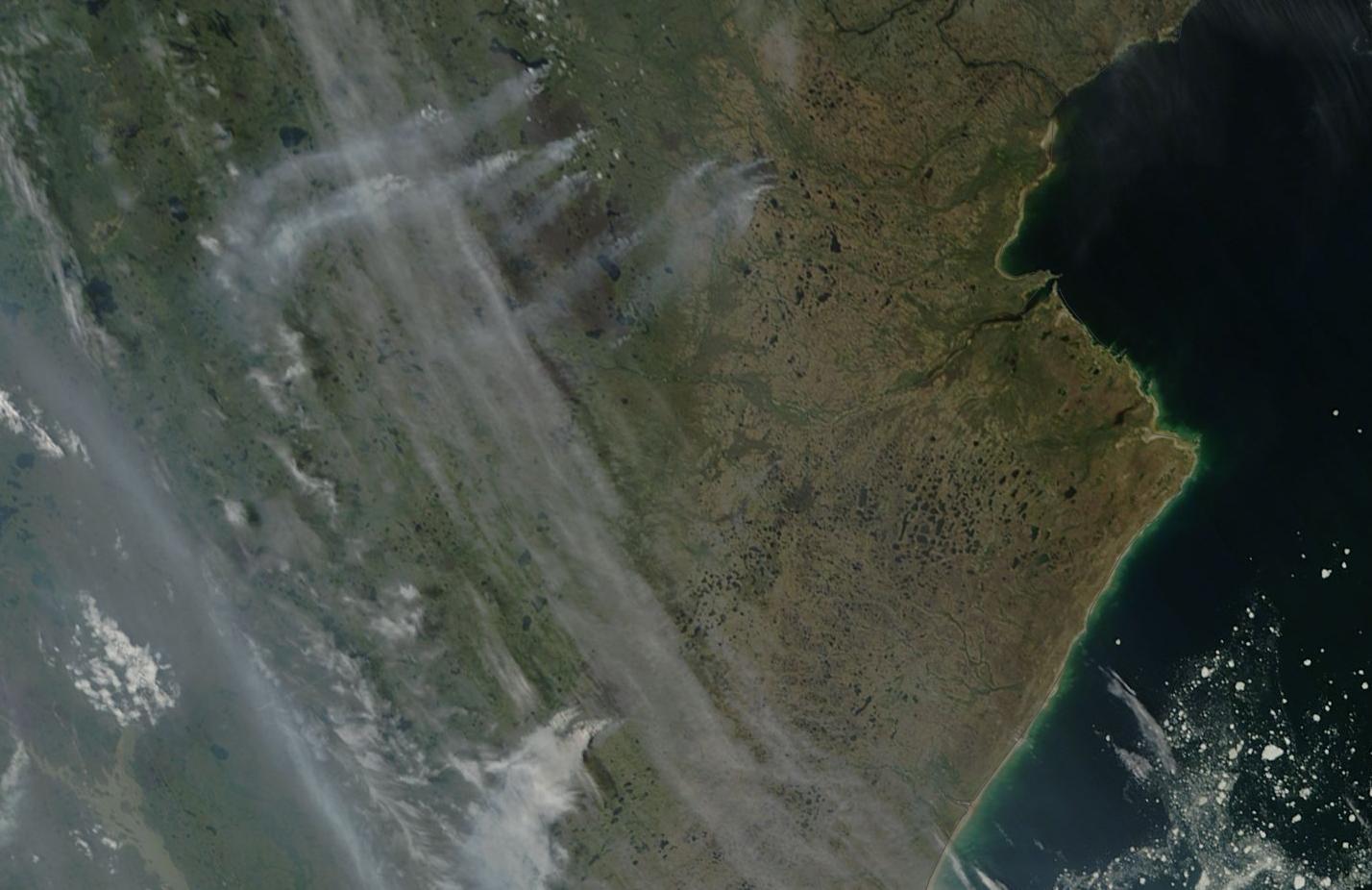
One cluster of these fires, visible in the upper left of the image frame above and zoomed in below features fires with fronts in excess of 50 miles long. These are truly immense fires. Individual blazes large enough to consume small states burning through the carbon rich boreal forests and permafrost zones:

Massive Siberian Wildfires

(Immense fires with fronts as long as 50 miles from end to end ballooned in Siberia today. Image source: LANCE-MODIS).

For reference, the above image’s lower frame edge covers more than 250 miles. This gives us a sense of the utterly huge fires burning away from lower right to center frame.

Conditions in Context — Human-Caused Warming Vastly Increases Arctic Wildfire Potential, Wildfires Make Climate Change Worse

The massive outbreaks of fires in Canada, Alaska and Eastern Siberia during 2015 are not occurring in a vacuum. They are not isolated disasters to simply report, confuse, forget, and then report again when the new record fires erupt in 2016, 2017, 2018 or 2019. They are instead symptoms of a larger trend of polar amplification in the Arctic.

The more than 1,400 billion tons of carbon in the permafrost is now being set to rapidly thaw. The permafrost, when unlocked from its primordial, thousands to millions year old, ice traps yields this carbon in solid, liquid, or gaseous form. The solid peats, the liquid organic carbons, and the methane seeps all provide new and highly volatile fuels for wildfires.

In addition, boreal forests are not fire resilient like their more southerly cousins. The trees there do not typically face flame or intense ignition sources. So when an atmosphere heated by human fossil fuel burning produces powerful, lightning flinging thunderstorms in the Arctic for the first time in thousands to millions of years, the trees there have no natural defense against the fires that inevitably ignite. Individual trees may as well be standing sticks of dynamite in the face of this warmth-driven barrage.

Other factors include tree killing pest invasions, the thin mat of flammable material that underlies most Arctic forests, and the drying tendency of the added heat itself.

So much forest, tundra soil and permafrost burning in the Arctic can eventually have its own sort of warming-amplifying effect. For the fires, fires that are likely not even natural to the slower periods of warming faced by Earth during past hothouse events, rapidly unlock the carbon stored in the forests as well as the rapidly thawing permafrost beneath. This release adds to the already extremely intense carbon emission from human beings and further heightens the danger of hitting climate points of no return.

This is the signal the media has lost in all its talk of ‘not abnormal’ and ‘arson.’ A warning cry from the Arctic. And one we had better not ignore.

Links:

Alaska Interagency Coordination Center

Canadian Interagency Fire Center

LANCE-MODIS

Alaska Wildfire Photos

Montreal Lake Wildfire at 250,000 Acres

Scary Statistics For Alaska Wildfire Season

Wildfires Set off Largest Evacuation in Saskatchewan History

How Climate Change Makes Wildfires Worse and How Wildfires Return the Favor

Hat Tip to Andy in San Diego

Hat Tip to Colorado Bob

Hat Tip to Alexander AC

Hat Tip to DT Lange

“Worst Fire Conditions On Record” — As Heatwaves, Drought Bake North American West, Wildfires Erupt From California to Alaska

There are 146 wildfires burning in Alaska today. A total that is likely to see at least another dozen blazes added to it by midnight. A total that has already absorbed the entire firefighting capacity of the State and has drawn hundreds of firefighters from across the country in places as far away as Pennsylvania.

For Alaska, it’s a case of record heat and dryness generating fuels for wildfires.

Alaska wildfires Sunday

(MODIS satellite shot of wildfires erupting over a sweltering Southwestern Alaska on Sunday, June 21. Wildfires in permafrost regions of the Arctic like Alaska are particularly concerning as they are one mechanism that returns ancient sequestered carbon to the Earth atmosphere. A sign of a feedback set off by human warming that will worsen with continued fossil fuel emissions. Image source: LANCE-MODIS.)

Deadhorse, at the center of North Slope oil fields above the Arctic Circle set an all time record high of 82 degrees Fahrenheit (28 Celsius) on Sunday. That’s 3 degrees hotter than the previous all time record high of 79 degrees (26 C) set on August 16, 2004. The hottest reading for June at that location was a 68 degree (20 C) measure set in 2007. So, basically, Deadhorse just shattered the all-time record for June by 14 degrees (F) and the globally record hot summer of 2015 has only now gotten started.

Other locations experiencing new records for just Sunday included Kotzebue, which set a new all time record highest low temperature of 62 degrees (17 C). This reading broke the previous all time high minimum mark of 56 degrees (14 C), set in 1987. Bethel and Yakutat both tied their daily high minimum temperature records at 54 and 52 degrees (12 and 11 C), respectively.

And yesterday was just one day in long period of record heat for the State. Last month’s NOAA analysis showed temperatures fully 7 degrees Fahrenheit (4 C) above average. It’s a record heating that is now setting off severe wildfires all over Alaska. According to the state’s Wildland Fire Information Center, the relentless heat and dryness has turned spruce, hardwoods, brush, and tundra into dry fuels vulnerable to any ignition source. Over the past week, ignition has come in the form of lightning — with most of Alaska’s 2015 wildfires set off by nature’s spark.

As a result we are seeing nearly double the number of fires during June compared to a typical year. Fires that have already destroyed 30 structures, forced evacuations, and tapped Alaska’s firefighting resources to its limits.

Wildfires Burning in the Rainforests of Washington as Major Heatwave Approaches

Record hot temperatures and wildfires, unfortunately, are not just an issue for Alaska. They’re a prevalent concern all up and down Western North America. A zone that has seen several years of record hot temperatures and dryness. Extreme weather events fueled by such global warming-linked phenomena as a Ridiculously Resilient high pressure Ridge over the Northeast Pacific that has kept heatwave and drought conditions firmly entrenched throughout much of the region for months and years. An atmospheric condition that is also linked to a hot ocean surface water ‘Blob’ in the Northeast Pacific (which is itself implicated in a growing number of marine species deaths).

Paradise-Fire-June-17

(Paradise Fire burning near a drought-shrunken creek in the rainforests of Olympia National Park, Washington. Image source: NPS and Wildfire Today.)

This week, the added heat also generated wildfires in unusual areas like the rainforests of Washington State’s Olympic Peninsula. Driest conditions since 1951 have resulted in a great deal of fire resiliency loss for forests in the region (1951 was the year of the historic Five Forks Fire, one of the worst ever to impact Washington State). Already, a rare early summer wildfire (called the Paradise Fire) has burned through 417 acres of forest.

Firefighters are doing their best to contain the blaze. But the record heat and dryness are multiplying fuel sources. Fires are enabled by dried lichens growing high up in the trees. When flames touch the lichens they rapidly ignite sending sparks to other lichen-covered tree tops. In this way, flames can leap rapidly from tree to tree under current conditions.

It’s very unusual to see fires in this rainforest zone. And when ignitions have occurred in those very rare cases, they have typically flared during late Summer and early Fall. So this June burning has fire officials very concerned — especially given the nearly unprecedented fire hazard conditions throughout the State. Conditions that are predicted to rapidly worsen as an extreme heatwave is expected to build through the coming weekend.

West Coast Heatwave Saturday

(A major heatwave is predicted to invade the US West and Northwest States this weekend. Washington and Oregon are predicted to experience temperatures more typical of desert sections of California and Arizona. Image source: Climate Reanalyzer.)

Temperatures over large stretches of Washington and Oregon are expected to climb into the 90s and 100s, possibly reaching the 110s (Fahrenheit — Celsius range from 33 to 45) by Sunday. For these typically cool, wet States, this brutal heat blow, should it emerge as predicted, will set off a spate of all time record high temperature readings, deepen drought conditions extending northward from California, and heighten fire conditions that are already in the range of worst ever experienced for sections of these States.

California Experiencing “Worst Fire Conditions On Record”

Moving further south along the U.S. West Coast we come at last to the drought hot zone that is California. A State that is now enduring its fourth year of drought. A drought that tree ring studies show is likely the worst such event in 1,000 years.

These harsh climate conditions were starkly highlighted this weekend as reports from State emergency planning officials now indicate that California is currently experiencing its worst fire conditions on record.

Ken Pimlott, Director of CAL FIRE noted:

We measure the fuel moisture content of all of the vegetation -the brush and the trees and we track that over the course of time and compare it month to month each year. And we put it through formulas and determine how much energy and how much heat it will put out when it’s burning. And we have seen -we saw it last year and we will see it again this year- we’ll be reaching records for potential heat output for times of the year that would normally not be burning in those conditions.

Wildfire nonexistent snowpack

(Large wildfire burns in forests along the slopes of Sierra Nevada Mountains whose peaks are now entirely devoid of snow cover. Note that remaining glaciers are shown turning a dull brown in the June 21 MODIS satellite shot.)

So far this year over 1,100 wildfires have already ignited throughout the State. That’s nearly twice the typical number of 650 blazes popping up by this time of year. Exacerbating this stark context is a state water resource crisis compounded by non-existent Sierra Nevada snowpacks and dead trees that now number in the millions.

This is not Normal, Nor Should We View Widespread, Related Events in Isolation

Record and unusual Alaska, Washington, and California wildfires this season are, thus, not occurring in isolation, but as an inseparable feature of ongoing climate trends related to human-caused global warming. In this case, heatwaves are related to visible and extreme record ocean and atmospheric temperatures that have been ramping both globally and in the regions affected over past years and decades. And the fact that 2015 is continuing as the hottest year on record globally should also not be viewed as separate from the events witnessed all up and down the North American West Coast. Events that were largely predicted in many global climate models assessing the impacts of human based greenhouse gas warming on this vital national and global region.

We’ll end here by considering this thought — it’s only June, yet up and down the North American West Coast we are experiencing some of the worst heat, drought, and fire conditions ever recorded. It’s only June…

*   *   *   *

UPDATE NOON EST, JUNE 23, 2015: Satellite Imagery confirms that, over the past 24-48 hours, the wildfire situation in Alaska has continued to worsen. Widespread and large fires running throughout southwestern, central, northeastern and eastern Alaska today expanded and multiplied:

Wildfires Alaska June 22

(Fires flared to dangerous size across Alaska on June 22nd and 23nd. Image source: LANCE-MODIS)

These rapidly proliferating fires cover a diagonal swath stretching about 800 miles from southwest to northeast across the state. The fires are burning through Alaska’s permafrost zone and current intensity in the satellite image is similar to some of the worst Arctic fires we’ve seen during recent years. A substantial number of these fires feature smoke footprints indicating 5-10 mile active burn fronts. Smoke plume size is now large enough to become caught up in the Jet Stream and impact visual features of skies across the Northern Hemisphere.

Based on these satellite shots, it appears that Alaska is experiencing a heightening and very severe fire emergency — one that shows little sign of abatement over the next few days.

Links:

Deadhorse Sets New All-Time Record High Temperature

NOAA Global Analysis May 2015

Alaska’s Wildland Fire Information Center

More Than 100 New Fires Spring Up Across Alaska

PA Firefighters Heading to Alaska to Battle Wildfires

Wildfires Burn in Olympic Rain Forest

Climate Reanalyzer

LANCE-MODIS

California Fire Says 2015 Fire Conditions are Worst on Record

Die-off of Millions of California Trees Centered in Sierra Nevada

Hat Tip to DT Lange

Hat Tip to Andy in San Diego

Permafrost Fires Advancing Toward Arctic Ocean Shores

Smoke from Siberian Tundra Fires August 1, 2014

(Smoke from Siberian permafrost fires entrained in wind pattern blowing over the East Siberian and Laptev seas. What can best be described as a synoptic pattern of smoke stretching for more than 2000 miles. For reference, we are looking at the heart of Siberia, the bottom edge of frame touches the Arctic Ocean. Total width of frame is more than 2000 miles. Image source: LANCE-MODIS.)

From the Northwest Territory of Canada to a broad central section of Russian Siberia called Yedoma, the permafrost fires this year have been vicious, powerful and colossal. They have burned deep into the basement soil and permafrost layer, casting out billows of dense, smokey material that, at times, has blanketed a majority of both Siberia and the North American Continent.

In Minnesota, two thousand miles away from the still raging Northwest Territory fires, James Cole, who comments here frequently, noted:

Forest fire smoke here in N.E. Minnesota was off the charts yesterday! I went out to watch the blazing red sun sink below the green hills. This almost invisible red ball brought back an old memory from watching a sun set in San Diego County during a very bad fire out break back when I was home ported with my ship there. These Alberta fires are a huge distance from here, but I can guess at their size by the thick gray haze, the smell and a sunset just like one in an active fire zone. (In confirmation to this eye-witness report, the Minnesota Star Tribune’s Meteorologist Paul Douglas reports Heat, Smoke, and Thunder)

Smoke Plume GOES

(GOES satellite shot of smoke plume from Arctic fires crossing Minnesota late yesterday evening. Image source: GOES.)

You can see the vast plume of filtering across Minnesota in the above GOES satellite shot.

Fires that Burn Soil

These fires aren’t anything normal. They burn the land as well as the trees. They cast off an inordinately high volume of smoke, such that they are far more visible in the satellite shot than more southerly fires of similar size. And they continue to burn for weeks and weeks — with lands that were lit nearly a month ago still casting off smoke and fire from the same locations.

The quantity of material necessary to keep such fires burning from the same location day in, day out, must be immense and it is becoming increasingly obvious to this observer that woodland as well as the soil and, likely, the thawing permafrost itself have become involved. It is a basement layer that, when fully thawed can be scores of feet deep. A set of peat-like material that, were it to be sequestered, would likely turn into a hundreds foot deep seam of coal over ages of heat and pressure. Instead, it is now being liberated as fuel for fires by human-caused warming.

Wildfire burning near Laptev Sea August 1, 2014

(Wildfire burning near Laptev Sea on August 1, 2014. The terrain in this region is tundra and tundra lakes, similar to the Yamal region where methane outburst sites where recently discovered. Wildfire is the comet like feature in upper center frame. The shoreline of the Laptev is visible along the lower frame border. Note the steely gray pallor of smoke running south to north [top to bottom] through the image frame. For reference, bottom edge of frame is about 150 miles, fire front is approximately three miles. Image source: LANCE-MODIS.)

On the Canadian side, the fires have primarily remained in the same region, simply continuing to burn from mostly the same sources or spreading only to local areas. But on the Russian side, the fires have leapt from their original cauldrons to ignite in massive blazes along regions both east and west, north and south.

Over recent days, fires have been creeping northward along a ridge line toward the Laptev Sea. Yesterday, a large fire ignited in the treeless tundra just 70 miles south of Arctic Ocean waters. You can see a close up image of this fire in the MODIS shot above.

So we have hard tundra burning just 70 miles south of the Arctic Ocean. No trees here, just an endless expanse of thawing ground.

Links:

LANCE-MODIS

Heat, Smoke, and Thunder

Hat tip to Colorado Bob (First Observation)

Hat tip to James Cole


Polar Jet Stream Wrecked By Climate Change Fuels Unprecedented Wildfires Over Canada and Siberia

This year, the warm air invasion started early. A high amplitude ridge in the Jet Stream stretching for thousands of miles over the temperate Pacific and on up into Alaska and the Chukchi Sea slowly drifted eastward. Reinforced by a powerful bank of blocking high pressure systems over the northeastern Pacific, this ridge settled over Canada’s Northwest Territory in a zone from the Mackenzie Delta and over a broad region east and south. From mid June onward, temperatures in the 70s, 80s and even low 90s dominated sections of this Arctic region.

The heat built and built, drying the shallow soil zone over the thawing permafrost creating a tinder-dry bed layer waiting for the lightning strikes that were bound to follow in the abnormal Arctic heat.

By late June, major fire complexes had erupted over the region. Through early and mid July, these massive systems expanded even as the anomalous heat dome tightened its grip. Today, the fires in Northwestern Canada have reached a horrific intensity and one, the Birch Complex fire, alone has now consumed more than a quarter of a million acres.

According to reports from Canada’s Interagency Fire Center, total acres burned to date are more than six times that of a typical year. A rate of burning that, according to a recent scientific study, is unprecedented not just for this century, but for any period in Canada’s basement forest record over the last 10,000 years.

Birch Creek Fire Complex Aerial close-up of Birch Creek Fire complex

(Thunderstorm? No. Smoke from a major volcanic eruption injecting ash into the stratosphere? No. The upper frame shot is an aerial photo taken of the Birch Creek Fire Complex on July 14, 2014 from a distance of about 30 miles away. It is just one of the massive fires now raging in the Northwest Territory region of Canada. A closer picture, taken from a few miles out, reveals the flaming base of a massive smoke plume. Image source: NWT Fire Facebook.)

From helicopter and airplane, the volume of smoke pouring out of these massive tundra and boreal forest fires is amazing, appearing to mimic major thunderstorm complexes or volcanic eruptions. Closer shots reveal towering walls of flame casting billows of smoke thousands of feet into the air above.

The smoke from these fires, now numbering in excess of 186 separate blazes, is becoming entrained in the weakening circumpolar Jet Stream. The steely gray billows now trail in a massive cloud of heat-trapping black carbon that stretches more than 2000 miles south and east. Its southern-most reaches have left residents of the northwestern and north-central US smelling smoke for weeks, now. Meanwhile, the cloud’s eastern-most reaches approach Baffin Bay and the increasingly vulnerable ice sheets of Greenland.

Smoke from Canadian Wildfires drifts toward Greenland

(Satellite shot of smoke from massive fire complexes over Canada spreading eastward. Black carbon and related CO2 emissions from forest fires can serve as a powerful amplifying feedback to already dangerous human-caused climate change. Image source: NASA/LANCE-MODIS.)

Across the Arctic, Siberia Also Burns

As media attention focuses on the admittedly horrific fires of unprecedented magnitude raging over Canada, a second region of less well covered but possibly even more extensive blazes burns on the other side of the Arctic Ocean throughout the boreal forest and tundra zones of Central Siberia in Russia.

There, record heat that settled in during winter time never left, remaining in place throughout summer and peaking in the range of 80-90 degree Arctic temperatures over the past couple of weeks. Over the last seven days, massive fires have erupted which, from the satellite vantage, appear about as energetic as the very intense blazes that ripped through Siberia during the record summer fire year of 2012. It is a set of extreme conditions we’ve been warning could break out ever since March and April when intense early season fires ripped through the Lake Baikal and Southern Yedoma regions.

Now, what appears to be more than 200 fires are belching out very thick plumes of smoke stretching for more than 2000 miles over North-Central Siberia and on into the recently ice-free zone of the Laptev Sea:

Sea of Smoke and Fire From Lake Baikal to Arctic Ocean

(Massive sea of smoke and fire stretching from Lake Baikal and northeast over Central Siberia and on into the Arctic Ocean. Image source: NASA/LANCE-MODIS.)

As with the other set of fires in Canada, the smoke from these massive blazes is entraining in the Jet Stream and stretching across Arctic regions. An ominous blanket of steely gray for the roof of the world and yet one more potential amplifying heat feedback the Arctic certainly does not need.

Potential Amplifying Feedbacks in Context

During recent years, scientists have been concerned by what appears to be an increased waviness and northward retreat of the northern hemisphere Jet Stream. This retreat and proliferation of ridge and trough patterns is thought to be a result of a combined loss of snow and sea ice coverage over the past century and increasing over the past few decades. In 2012, sea ice coverage fell to as low as 55% below 1979 levels with volume dropping as low as 80% below previous values. Over the past seven years, not one day has seen sea ice at average levels for the late 20th Century in the north.

Meanwhile, northern polar temperatures have risen very rapidly under the rapidly rising human greenhouse gas heat forcing, increasing by 0.5 C per decade or about double the global average. It is this combination of conditions that set the stage for fixed ridges over both Russia and Canada creating extreme risk for extraordinary fires.

image

(Weak and wavy polar jet stream on July 17, 2014 shows fixed ridges over the Northwest Territory, Central and Eastern Siberia, Northern Europe and the adjacent North Atlantic and Arctic. Image source: Earth Nullschool. Data Source: NOAA GFS and various.)

Should both the current sets of fires continue to rage under anomalous high amplitude jet stream waves setting off extreme heat in these Arctic regions, it is possible that large clouds of heat absorbing black carbon could ring the Arctic in a kind of hot halo. The dark smoke particles in the atmosphere would trap more heat locally even as they rained down to cover both sea ice and ice sheets. With the Canadian fires, deposition and snow darkening are a likely result, especially along the western regions of the Greenland Ice Sheet — zones that have already seen a multiplication of melt ponds and increasing glacial destabilization over recent years.

Recent scientific studies have also highlighted the possibility that human-caused climate change is increasing high amplitude jet stream ridge patterns that are transporting more and more heat into Arctic tundra and boreal forest regions. These regions are more vulnerable to fires due to the fact that trees in boreal forest have uniform characteristics that favor burning and tend to rapidly ignite and spread once the upper branches become involved. The unfrozen soil features a narrow basement layer above tundra which dries more rapidly than the soils of more temperate areas, providing tinder fuel to aid in the initial ignition by lightning strike. Thawing, deeper tundra, when dried, is a meters-deep pile of fuel that has accumulated for thousands of years — a kind of peat-like layer that can smolder and re-ignite fires that burn over very long periods. It is this volatile and expanding basement zone that is cause for serious concern and greatly increases the potential fire hazard for thousands of miles of thawing tundra going forward.

Overall, both boreal forest and thawing tundra provide an extraordinary potential fuel for very large fire complexes as the Arctic continues to warm under the human greenhouse gas forcing. And though climate models are in general agreement that the frequency of fires in tundra regions will increase, doubling or more by the end of this century, it is uncertain how extensive and explosive such an increase would be given the high volume of fuel available. Direct and large-scale burning of these stores, which in tundra alone house about 1,500 gigatons of carbon, could provide a major climate and Earth System response to the already powerful human heat forcing.

Though the science at this point is uncertain, we observe very large and unprecedented fire outbreaks with increasing frequency:

“I think it’s really important for us to take advantage of studying these big disturbance events,” noted Dr. Jill Johnstone in a recent interview. “Because, if we can say anything, we can say that we think they’re going to be more common.”

UPDATE:

The smoke plume over North America has now expanded to cover a large section of the continental land mass. As you can see in the image below provided by NOAA, the smoke plume now stretches from the fire zones in the Northwest Territory (fires indicated by red dots), British Columbia, Washington, Oregon and California across much of the North American continent extending as far to the north and east as the southern tip of Greenland and as far to the south and east as Maryland, West Virgina and Tennessee:

Smoke Plume

(Massive North American Smoke Plume fed by Tundra and Western Forest Fires. Image source NOAA.)

As of today and yesterday (17 and 18 July) major wildfires continued to burn over much of the Northwest Territory of Canada even as these very large and unprecedented fire complexes were joined by massive outbreaks in British Columbia, Washington and Oregon. Fire outbreaks were so extreme in both Washington and Oregon that state officials there were forced to declare states of emergency and seek federal assistance for dealing with the ongoing disasters.

You can see the large, steely-gray smoke plumes from these fires in the LANCE MODIS image taken by NASA yesterday in the satellite shot below:

Massive fire complexes in Washington, Oregon and BC

(Massive wildfires in Washington and Oregon prompt officials to issue disaster warnings. Image source: LANCE-MODIS.)

The smoke has become so pervasive that commenter James Cole has made some rather stark observations from Northern Minnesota:

A sky filled with grey haze, you can hardly tell there is a sun up there. No clouds in the sky, but the haze is incredible. Surely from the great Canadian fires!

Due to black carbon loading, such a large cloud of smoke may result in substantial temperature spikes over regions affected. The heat dome over the US West is expected to expand into the central and northern US this weekend with some readings there predicted to reach the 100s. Already, the southwestern heat is spreading north and eastward under the dome of heat-intensifying smoke with a broad area of upper 80s and lower 90s stretching all the way to the southern shores of Hudson Bay.

Meanwhile, on the other side of the Arctic, the expanse of wildfires continued to widen with the smoke plume now covering over 2,500 miles and with multiple very large blazes continuing over Central and Northeastern Siberia. Atmospheric black carbon and methane loading (more in a new post) likely contributed to temperatures in the range of 95 degrees F (35 C) near the shores of the Arctic Ocean’s Laptev Sea yesterday as recorded in the following screen capture from Earth Nullschool/GFS:

image

(35 C temperature [95 F]  recorded in northeastern Siberia near the Laptev Sea at about 12:30 AM EST on July 18. Image source: Earth Nullschool. Data Source: NOAA/GFS.)

Links:

Fires in Northwest Territories in Line with Unprecedented Burn

What Fires in the Northwest Territories Say About Climate Change

Recent Burning of Boreal Forest Exceeds Fire Regime Limits of Past 10,000 Years (PNAS)

NWT Fire Facebook

NASA/LANCE-MODIS

Earth Nullschool

NOAA GFS

Arctic’s Boreal Forests Burning at Unprecedented Rate

Large Particles From Wildfire Soot Found to Trap 90 Percent More Heat Than Small Particles

North American Smoke Plume Tracking by NOAA

Hat tip to Wili

Hat tip to James Cole


Dozens of Massive Wildfires in Central Siberia Belch 1,200 Mile Smoke Plume Over Hot Tundra

1,200 mile smoke plume

(Dozens of monstrous fires belch a 1,200 mile plume of dark smoke over Central Siberia. Image source: LANCE MODIS.)

Let’s just cut to the chase, it’s been hot in Siberia.

This winter, temperatures throughout large swaths of this typically frigid land of tundra and boreal forest ranged between 5 and 7 degrees Celsius above average. For brief periods spikes in the very extreme range of 20 degrees Celsius warmer than normal were not uncommon.

The unusual heat continued into spring igniting a mass of anomalous wildfires in April, a time when most of Siberia remains frozen. By May, more than a million acres had burned, all well before the typical peak of fire season in July and early August. But that was mere prelude to peak fire season, which we are starting to enter now.

Siberian Heatwave Spurs Massive Fires

The record heat this winter was simply the continuation of a long warming trend fueled by human greenhouse gas emissions. Each decade now has seen Siberia warm at a pace double the global average — more than 0.5 degrees Celsius every ten years. And this extra heat is fueling a terrifying intensification of wildfires, a trend that is expected to show at least a doubling of the annual acres burned in this far northern region by the end of this century.

This year’s early start to fire season may be setting the stage for a record or near record burning this year. And today we have a massive flare up of fires in Central Siberia under a broad heat dome over the region.

Temperatures beneath the dome earlier today were in the upper 80s and lower 90s, departures between 5 and 15 degrees Celsius above average for this time of year. This heat spike hit already warmed and dried lands. Lands filled with the added fuel of thawing tundra and the organic carbon and methane pockets beneath. Lands whose shallow surface layer is a tinder bed for flash fires.

Siberian Heat Dome

(Heat dome over Central Siberia in the upper right hand corner of this GFS based-temperature and weather graphic. Image source: University of Maine. Data source: NOAA/GFS.)

The result was the massive wildfire eruption seen in the satellite shot at the top of the page. A very intense set of enormous fires with fronts ranging from 3 to 34 miles burning through boreal forest and tundra land. This set of blazes is even more intense than those seen at this time during the record 2012 Siberian fire season, although it is worth noting that those fires hit extraordinary strength and size by early July and continued in a series of episodes through mid August. The result was massive smoke plumes eventually encircling the Arctic.

Typically, the fires fill the air with particulate and the moisture loading under the heat dome grows ever more intense. Often, and sooner rather than later, a frontal storm accompanied with intense rains sweeps in, catching up the smoke in its cloud mass even as the towering storms douse the raging fires. A song of flood and flame that has become all too common throughout the very rapidly changing Arctic.

In years of very extreme burning, the smoke-laden clouds darken, losing their white, reflective tops. This further amplifies warming over fire-prone areas, setting the stage for more fires. On the ground, the fires plunge ever deeper into the thawing tundra, seeking more and more fuel. In some cases, the fires are reported to have burned the ground to a depth of 3 feet or more, turning both Earth and Tundra into blackened soot while pumping heightening volumes of CO2 into the atmosphere. The dark smoke aloft lifts away, eventually finding a resting place on sea ice or glaciers. There the heating feedback continues over ominously Dark Snow.

The whole terrible process continues until the globe at last tilts away from the summer sun, shutting the whole dreadful feedback down. But each year, we fuel it more through our burning of fossil fuels. Each year, the global greenhouse gas heat forcing ratchets higher and more and more tundra land thaws as the burn line creeps north, providing ever more fuel for the Arctic flames.

Links:

Support the Dark Snow Project

A Song of Flood And Fire

Support and defend our scientists at:

NASA/LANCE MODIS

The University of Maine

NOAA/GFS


Arctic Burning: 3/4 Mile Wide Fire Tornado Over Tetlin Junction, Alaska

(Hat tip to Peter Sinclair who thumbs his nose at the deniers stating, in reaction to this Fire Tornado: “sure, happens all the time.”)

The above is a film recorded on August 16th, 2013 of an explosive fire complex forming a massive fire and smoke tornado 3/4 of a mile across and towering thousands of feet into the air over a ridge line near Tetlin Junction Alaska. Close inspection of the video reveals trees and branches being sucked into the large fire ‘tornado’ caused by very strong inflow along the fire’s leading edge. Tim Whitesell, a firefighter at the scene noted:

“A picture probably is worth a thousand words, but there are indeed times when a picture just doesn’t do it justice. I’ve never seen anything like it until now.”

The terrain features in this region include boreal forest and soil that is mostly permafrost. The film shows both burning trees and ground along with a section involved in an episode of explosive outburst.

Reports from from The Alaska Fire Service are nothing short of stunning:

“This wildland fire footage was captured on August 16, 2013, on the southeast perimeter of the Tetlin Junction Ridge Fire (#414), burning east of Tok and Tetlin junctions, north of the Alaska Highway.

Fire behavior increased into the later part of the afternoon on August 16. At approximately 7:00 p.m., the Alaska Division of Forestry Aerial Supervision Module (consisting of Tim Whitesell and Doug Burts) reported the fire vortex to be about 3/4 of a mile wide; it lasted for about an hour. The extreme fire behavior uprooted trees, a scene that was captured by this footage- look for trees being blown around in the smoke column at the end of the clip.”

The blaze that sparked this massive fire tornado is arguably one of the smaller events to impact the Arctic this year, just a fraction of the size of larger infernos that have raged through areas of Canada and Russia since June. In ‘Russia Experiences Great Burning’ MODIS shots identified fire complexes and burn scars that covered 100 to 300 square miles or more (one fire burn scar measured a massive 30×70 miles). These events happened ‘off camera’ so there is no way to know if they also spawned very large fire tornadoes similar to the kind witnessed at Tetlin Ridge. What is clear from this fire and from fires across the Arctic this year and last is that the far north is burning like never before. As Russia’s eastern provinces experienced some of their worst flooding in 120 years, massive wildfires continued to burn even as the terrible rains and storm complexes advanced in an ominous Song of Flood and Fire. By now, the extent of Russian blazes has been somewhat lessened by these storms, although fire maps still show numerous active blazes.

A satellite picture of the blazing ridge-line on August 15 is given below.  The fire is located in the center of the image and spans about 5×10 miles of the affected ridge line. You can also see the burn scars of previous wildfires in the lands surrounding the August 15-16 blaze.

Tetlin Junction Fire Tornado

Tetlin Junction Fire Tornado

(Image source: NASA/Lance-Modis)

Thawing permafrost, warming forests, Arctic heatwaves and more energetic storms combine to provide massive volumes of warming fuel and increasingly powerful ignition events in the Arctic. Not only can trees burn, but the organic carbon stored in permafrost and sometimes bottled up as methane beneath the surface also provides fuel. In many cases, fires have burned three feet deep into what was the permafrost bed below consuming roots, stumps and soil.

Very large and energetic fire outbreaks have been increasing throughout the Arctic with recent years seeing some of the worst fires on record.

Links, Credits and Hat Tips:

The Alaska Fire Service

Climate Crocks

NASA/Lance-Modis

Colorado Bob

Robin Westenra

It’s Hotter Up North than Down South: Tundra Fires Erupt Over Canada as Heatwave Pushes to Arctic Ocean Shores

Tundra Fires Near Lake MacKenzie

Tundra Fires between 62 and 66 degrees North

(Image source: NASA/Lance-Modis)

Over the past week, large tundra fires have been erupting over a section of extreme northern Canada between the Great Slave Lake and the shores of the Canadian Arctic Archipelago. With a major Arctic heatwave predicted as various extreme weather conditions arise, this region will be worth very close monitoring over the next few days.

The fires are emerging in a region of the Arctic between 62 and 66 degrees north latitude, near the Arctic Circle. In the image above, we see the Great Slave Lake in the lower left hand corner, the Great Bear Lake in the upper center, and Coronation Gulf and Amundsen Bay bordering the map’s right hand side. The fires are visible, along with their tell-tale smoke plumes and underlying scorch marks, in a region between the Great Slave Lake and Great Bear Lake. Terrain type in the regions burned include boreal forest and tundra.

Weather conditions over the past two weeks have been both warm and dry for this Arctic region. But over the past few days, temperatures have been heating up. As temperatures rose, wildfires sparked and grew. Forecasts now call for a region of very hot Arctic weather to stretch all the way to the shores of the Beaufort Sea by Friday with temperatures likely to exceed 30 degrees C (86 degrees F) over the broad stretch of land surrounding the Mackenzie Delta.

This high Arctic heat pulse is being driven north by a powerful high amplitude wave in the Jet Stream which is setting up very extreme temperature differentials between the Beaufort Sea and North Canadian land masses. Temps over the Beaufort are now in the range of -5 degrees C in some areas (about 22 F), with temperatures over land hovering, at this time, in between 15 and 23 C (60s and 70s) and predicted to surge as high as 30 C + (86 F+). This amazing temperature differential is likely also providing fuel to a powerful 978 mb (Smokey) Arctic Cyclone now traversing from the Laptev and into the Central Arctic. It will also intensify winds and drive greater heating over Arctic land masses over the next few days.

Heatwave Hits Arctic Ocean Shores

(Image source: Arctic Weather Maps)

The map indicates forecast daytime temperatures for the Northern Hemisphere land masses bordering the Arctic on Friday, August 9, 2013. Note the highly anomalous condition in which temperatures are predicted to be hotter further north, over regions near the Mackenzie Delta, than they are further south. This is an extraordinary inversion and one certainly worth putting into the context of the extreme weather conditions that are now ongoing. (Areas of red on the map indicate average temperatures in the range of 77-86 degrees (F). Maximum daily values are likely to exceed this average predicted range.)

Though not as massive or extensive as the fires raging across the Arctic Ocean in Russia, these fires are still quite large — with burn marks stretching 6 or more miles at their widest point in many cases. Another region just west of the fires shown in the image above is also experiencing a very large blaze. This complex of fires is raging along the banks of the Mackenzie River and is shown to have a fire line more than ten miles across at its widest point.

Mackenzie River Fire

Mackenzie River Fire

(Image source: NASA/Lance-Modis)

Note the extremely large scorch mark to the lower center portion of the map, with a large, energetic fire blazing in the upper right portion of the map and a smaller, though still substantial, blaze erupting to the upper left.

As noted above, fire-conducive conditions for this region are forecast to intensify well before they moderate. So this particular spate of fires may well be just starting to ramp up.

For a final note, I’d like to add the observation that this event represents a bit of rather harsh irony. These fires now rage in a region dominated by Canada’s Tar Sands Industry. Carbon is being baked and burned out of the land and soil by anomalous heat caused by human warming and not just by the immense grind and crush of fossil fuel industry. The steps of carbon extraction, in this case, have been shortened and are now out of our control.

Russia Experiences Great Burning: Satellite Shots Show ‘Sea of Smoke and Fire’ Blanketing Russia

I don’t know what’s more troubling — the vast size and extent of smoke and wildfires blanketing Siberia and Russia, or the almost complete silence from Russia and the mainstream media on what appears to be a massive, ongoing climate disaster (Note: NASA did provide an excellent press release via the Earth Observatory link here and below).

In 2010, Russia experienced a deadly heatwave that set off terrible wildfires that belched smoke over many of its more populous cities. These fires spread over a region closer to Europe and so they had great impacts on both property and lives. In 2012, Russia experienced a second spate of massive fires, but these raged over more remote sections of Siberia. At first, Russia was slow to respond. Then, it mobilized an army of firefighters — thousands and thousands — to fight scores of blazes raging across its large, remote Arctic regions. The smoke cloud from these fires was so large it eventually covered a section of the Northern Hemisphere from Siberia to the west coast of North America. Valleys in British Columbia filled with the stench of burning from fires thousands of miles away spurring phone calls from concerned Canadian locals to fire departments there.

Then comes 2013. From spring to summer, central Siberia sweltered under a near constant drought and intermittent heatwaves as a very high amplitude ridge in the Jet Stream enabled a powerful heat dome to form during June and then re-form during late July and early August. The late July heat surge appeared to be the final insult setting off an enormous rash of fires throughout central Siberia and Russia. By early August the number of fires raging out of control swelled to 170. Today, the number is probably closer to three hundred. Human-caused climate change is, yet again, scarring Russia with a terrible set of burn marks.

It is difficult to look at today’s Aqua satellite shot and not stand in fear and awe.

Great Burning in Russia, August 5, 2013.

Great Burning in Russia, August 5, 2013.

(Image source: Lance-Modis)

What we are looking at in this shot is the entirety of north-central Russia covered by a boiling cloud of smoke under which a massive field of fires burn. In the north, the large smoke cloud is now spilling out over the Kara Sea. In the south, we can see it just reaching northern Mongolia. In the east, a string of very large fires are roaring through tundra and boreal forest near western Kamchatka. And in the west, a broad tongue of smoke juts off the map and on toward Moscow whose skies are just starting to darken with smoke.

Though normally this massive swath of smoke would be driven eastward over Kamchatka and then into the Pacific Ocean, a combination of a very weak Jet Stream flow and powerful heat dome high pressure system is funneling this smoke westward in retrograde to the prevailing upper level wind flow. This anomalous pattern is similar to an upper level low that took a backward course over more than 3,000 miles of the US, marching all the way to the Pacific Ocean and into climate change weather weirdness history.  But, in this case, smoke from hundreds of wildfires is being driven backward against the prevailing wind flow for nearly 5,000 miles. In both the former and the latter cases, the typical Jet Stream pattern has been completely compromised as large backward eddies dominate major Northern Hemisphere regions for extended periods.

Closer in Modis shots with heat map imagery provide us with fire locations beneath the smoke dome (Hat tip to Colorado Bob for his sharp eye).

Russian Sea of Smoke and Fire West on August 4, 2013.

Russian Sea of Smoke and Fire West on August 4, 2013.

(Image source: Lance-Modis)

If you cut the ‘Great Burning’ image I posted above in half, this shot would represent its western portion. Each red dot in the image represents a single wildfire. Some, which you can identify by their smoke plumes, are readily visible. Others are entirely masked by the massive covering smoke cloud.

Great Burning Russia East

Russian Sea of Smoke and Fire East August 4, 2013

(Image source: Lance-Modis)

On the eastern side of this great burning area in Russia, we find new, very large fires raging over Arctic Siberia and spreading into Kamchatka. It is difficult to exaggerate the immense side of some of these burn zones with the largest measuring 250×250 miles at its widest points. In this image, the large scorch marks left over by some of these fires begin to become visible. But zooming in on today’s Modis image provides even more clairity:

70x30 mile scorch mark left by a single, still burning, Russian wildfire.

70×30 mile scorch mark left by a single, still burning, Russian wildfire.

(Image source: Lance-Modis)

In this shot, we find a massive 70X30 mile scorch mark scarring both tundra and boreal forest land in Arctic Siberia. Other, smaller scorch marks from past fires are also visible in this image. But this single, recent burn mark is just one of many that are now spreading out over similar regions of the Russian Arctic.

Unfortunately, heat and dry weather are expected to persist in this region for at least the next week. The forecast for Monday, August 12 calls for 77-86 degree or higher temperatures to remain in place over much of Arctic Russia with cooling confined to only the most northerly regions.

Large swath of 77-86 degree temperatures predicted to remain over Arctic Russia on Monday, August 12.

Large swath of 77-86 degree temperatures predicted to remain over Arctic Russia on Monday, August 12.

(Image source: Arctic Weather Maps)

UPDATE: FURTHER READING ON THIS EVENT FROM NASA

(Hat tip to Prokaryotes)

NASA provided an excellent report on this particular event four days ago that is well worth reading:

The summer of 2012 was the most severe wildfire season Russia had faced in a decade. 2013 might be headed in the same direction after an unusual heat wave brought a surge of fire activity in northern Siberia in July.

A persistent high-pressure weather pattern in the Russian Arctic—a blocking high—contributed to the heat wave, which saw temperatures reach 32° Celsius (90° Fahrenheit) in the northern city of Norilsk. For comparison, daily July highs in Norilsk average 16° Celsius (61° Fahrenheit). Blocking highs are so named because they block the jet stream from moving rain-bearing weather systems along their normal west-to-east path; this leads to “stuck” weather patterns with long periods of stable air and exceptional heat.

(Read more here)


Heat Dome Wildfires, Methane Pulse Expand, Blanketing Arctic Siberia in Cloud of Dense Smoke

Heat Dome Fires Siberia

An immense cloud of smoke covers Arctic Siberia. Image source: Lance-Modis.


Add sea ice near record low levels, a mangled, wavy jet stream, heat dome high pressure systems that increasingly emerge in a thickening atmosphere, a global warming induced increasing of the hydrological cycle and warmth-amplifying methane seeps from the tundra and what do you get? Summer Arctic heatwaves that persist over days and weeks setting off temperatures in the 80s and 90s and sparking massive and terrifying fires that belch enormous clouds of methane-laced smoke larger than most countries.

***

Last week, a persistent Arctic heatwave re-intensified over Central Siberia, setting off a rash of wildfires while at the same time apparently forcing some of this region’s vast tundra methane stores to erupt. Throughout the weekend, these fires grew, expanding and multiplying, spurring Russia to call up nearly a thousand firefighters and a score of aircraft to combat these raging blazes. Fires continued to erupt throughout the weekend, growing in number to more than 170 separate blazes. This massive region of fires fed a vast cloud of smoke that has now expanded to cover an area about 2000 miles in length and 1200 miles in width.

NASA’s Aqua satellite has provided a recent image focusing in on the area featuring the densest cluster of these fires. The approximately 130 fires shown (but not including all the fires involved) are indicated in red. (Hat tip to Colorado Bob for the head’s up).

Massive wildfires, Russia

More than 130 wildfires, indicated in red, erupt across Siberia. Image source: Aqua/Modis.

Much hotter than average conditions persisted over most of this smog-covered region on Monday as the heat dome high pressure system associated with the scorching Arctic temperatures and wildfires moved retrograde to a feeble Jet Stream and on toward Europe. Daytime temperatures over much of this Arctic region ranged from the mid 70s to the upper 80s with some locations showing highs in the lower 90s.

Arctic temperatures, Daytime, Siberia

Monday daytime temperatures for Central Siberia. Red indicates 77-86 degrees Fahrenheit. Image source: Arctic Weather Maps.


These Arctic heatwave conditions are expected to first shift toward Europe then move back over Siberia, eventually settling upon Kamchatka by late this week. According to these model forecasts, heatwave conditions will continue to persist for sections of Siberia at least until the end of this week. So Russia will likely continue to be under the gun for wildfires as the week progresses.

Methane spikes continue

Perhaps the most troubling event to occur in conjunction with Arctic heatwave conditions and a very large wildfire eruption over Central Siberia’s tundras and arboreal forest land is a disturbing methane pulse, also indicated by the Aqua satellite. This methane pulse emerged in conjunction with the heatwave that began last week and appears to have intensified somewhat in recent days. According the Methane Tracker’s A4R, the large clouds of smoke associated with the massive spate of wildfires show heightened methane levels even greater than those first observed last week. In some cases, the methane in the smoke clouds is around 2,000 parts per billion, nearly 200 parts per billion higher than the atmospheric average.

Given these dramatically elevated methane levels, one has to wonder if the fires are enhancing methane emissions from the thawing Siberian tundra and peat bogs.

This particular methane pulse also comes at a time when scientists are increasingly concerned about the potential for enormous methane pulses in the gigaton or tens of gigatons range coming from thawing submerged tundra in the East Siberian Arctic Shelf. A recent Nature article examined the subject in depth and caused broad controversy within the climate community. A NASA mission investigating Arctic methane emissions called CARVE is also seeking to clarify risks involved with the immense methane stores now being unlocked as the Arctic Ocean warms and as the tundra thaws.

The current massive spate of Siberian wildfires now appears to be at least as large those that occurred during June of 2012. In that event, massive blazes sent smoke across the Pacific Ocean to fill valleys on the West Coast of North America. With another week of heatwave conditions set for this region, it is possible that these already extreme conditions will intensify. So we’ll be keeping a close eye on what appears to be a still developing extreme event.


Large, Troubling Methane Pulse Coincides With Arctic Heatwave, Tundra Fires

Siberian Heatwave July 23

Temperature color graphic. Areas in red indicate temperatures in the range of 77-86 degrees (Fahrenheit) but may not fully capture daily maximum temperatures.

(Image source: Arctic Weather Maps)

During a murder investigation, sometimes you find traces of smoke from a gun fired in relation to the crime. In other cases, sometimes you find the gun itself. Even more rarely, do you find a smoking gun dropped at a still fresh crime scene. Such was the case with the Arctic today.

The crime scene: another anomalous Arctic heat wave. The suspect: human caused climate change. The accessory: Arctic amplification. The smoking gun: major methane emission in the Arctic.

****

Yesterday, I reported that a large Arctic heat wave had settled over Siberia, once again setting off tundra fires. The heat wave was so intense that it pushed temperatures in a range of 77 to 86 degrees all the way to the shores of the Arctic Ocean even as it caused numerous massive blazes to emerge both on open tundra and throughout Siberia’s boreal forests. Atmospheric conditions — a Jet Stream mangled by human caused climate change and a large heat dome had enabled the formation of this heat wave.

But now we find something even more ominous than evidence that human global warming is moving the Jet Stream about all while pushing polar amplification into such a high gear that the terms ‘Arctic Heat Wave’ and ‘Tundra Fire’ have now become common meteorological parlance. And that thing is a large and disturbing methane pulse.

Methanesiberia7-23-13_zps5be4f30e

(Image source: Methane Tracker)

On July 21-23, a large methane emission in which numerous sources caused atmospheric spikes to greater than 1950 parts per billion flared over a wide region of Arctic Russia and the Kara Sea. This event was so massive that an area of about 500 x 500 miles was nearly completely filled with these higher readings even as a much broader region, stretching about 2,000 miles in length and about 800 miles at its widest, experienced scores of large pulses. You can see a visual representation of these emissions in yellow on the image above, provided by Methane Tracker which compiles data provided by NASA’s Aqua Satellite.

As noted above, this major event coincided with a large Arctic heat wave and numerous tundra fires that raged throughout the region. Another unprecedented occurrence in a summer of strange weather and mangled climate.

Conditions in Context

Average global methane levels are currently around 1830 parts per billion (Mauna Loa surface data). This level, about 1130 parts per billion higher than the pre-industrial average of 700 parts per billion represents an additional global warming forcing equal to at least 28% of the added CO2 forcing provided by humans. It has long been a concern among scientists that the Arctic environment, as it is forced to warm by human-caused climate change, would emit an additional significant volume of methane from carbon stocks locked in tundra and in methane stores sequestered on the sea bed. Since methane has between 25 and 105 times the heating potential of CO2, the possible added additional warming is quite substantial.

In the 2000s, a number of Arctic researchers found disturbing evidence of methane emissions coming directly from the Arctic environment. In 2013, NASA began its CARVE mission to more clearly define the Arctic’s response to human-caused warming. Its preliminary research has found methane plumes as large as 150 miles across.

Overall, the Arctic environment is already clearly adding its own methane to the global mix. We can see this in local Arctic methane measurements that average around 1900 parts per billion and above in many Arctic locations. These readings are about 70 parts per billion above the global average. This week’s large methane pulse where a broad region experienced methane levels of 1950 to 1980 parts per billion is yet more evidence that the Arctic is beginning to provide a dangerous and troubling amplifying feedback to the already break-neck pace of human warming. In total, around 2,500 gigatons of methane are thought to be locked in carbon stores both in the Arctic tundra and in hydrates (frozen methane and water) on the Arctic Ocean floor.

Though a dangerous and troubling addition to a human-caused warming that is already changing the world’s weather in harmful and damaging ways, this particular methane pulse is not yet evidence of runaway global warming. In a runaway, Arctic methane emissions would likely exceed 500 megatons per year, which would be enough to raise global levels by about 150 parts per billion or more annually. Such a runaway would be a global nightmare requiring an unprecedented human response if Earth’s life support systems were to be preserved in any rough corollary to what we enjoy today. Though such an event is probably still low-risk (but perhaps as high as 10-20 percent), it cannot be entirely ruled out due to the speed and violence at which human greenhouse gas emissions are altering Earth systems.

So the prudent course would be for a rapid response as if such an event were imminent. The reason is that a runaway methane emission in the Arctic would cause severe and untold damage and harm.

To this point, Peter Wadhams is warning that about 50 gigatons of methane are at risk of rapidly destabilizing should the Arctic sea ice melt in the next two years. The region in which these methane stores are locked is the East Siberian Arctic Shelf, a shallow sea that is very vulnerable to rapid warming and methane release. Wadhams notes:

The loss of sea ice leads to seabed warming, which leads to offshore permafrost melt , which leads to methane release, which leads to enhanced warming, which leads to even more rapid uncovering of seabed. If a large release has not occurred by 2016 the danger will be continuously increasing. It is thought that at 2-3C of global warming, which means 6-8C of Arctic warming, methane release from permafrost on land will be greatly increased.

Those who understand Arctic seabed geology and the oceanography of water column warming from ice retreat do not say that this is a low probability event. I think one should trust those who know about a subject rather than those who don’t. As far as I’m concerned, the experts in this area are the people who have been actively working on the seabed conditions in the East Siberian Sea in summer during the past few summers where the ice cover has disappeared and the water has warmed. The rapid disappearance of offshore permafrost through water heating is a unique phenomenon, so clearly no “expert” would have found a mechanism elsewhere to compare with this.

Perhaps, equally troubling, is that large regions of permafrost are now also thawing. In the Hudson Bay region, an area that saw unprecedented heat, dry conditions and wildfires this year, permafrost temperatures have risen by .45 degrees Celsius. Peter Kershaw, an adjunct professor of earth sciences at the University of Alberta, who was in Churchill recently on a research project noted:

“It’s a big concern and so far not well-quantified. That organic material is being made available for decomposition. It’s out of the freezer and sitting on the counter.”

Though most climate scientists do not currently believe that such a rapid release of methane is possible over such a short period, we do have to ask ourselves — what if Wadhams and others like him are right? In such a case we could see a catastrophic warming of up to 5 degrees C by 2050, far beyond anything mainstream models or paleoclimate would suggest. But the human rate of climate forcing that is now more than ten times anything seen during the geological record puts us in a context that is entirely out of previous reckoning. So these warnings by Wadhams should be listened to, heeded, and taken into account. (Hat Tip to commenter Colorado Bob for the head’s up on these articles).

More likely, however, is that a combination of methane release from the tundra and the ocean floor and a loss of albedo (reflectivity) due to ice sheet loss will result in an effective doubling or more of the initial human greenhouse gas forcing over the coming decades and centuries. Such a response is still very dangerous in that it risks locking in, long term, already damaging changes to the world’s environments. Should the Earth System fully respond to the 400 ppm CO2 and 1830 ppb methane we’ve already achieved through our emissions , we can expect at least a 3 degree Celsius global temperature increase and long-term sea level rise of between 25 and 75 feet. Such changes would severely damage both human infrastructure and the environments upon which human-based agriculture depend for its now vast food production. In addition, a 24% increase in the hydrological cycle and a number of destabilizing changes to the world’s weather systems would cause severe added damage.

A rapid Earth Systems feedback response risks these changes at current greenhouse gas levels. And since we are now seeing both methane release and ice sheet response, a level of these feedbacks are already in play, showing a far greater risk than initial forecasts indicated. Further greenhouse gas emissions risk even more damaging potentials, possibly locking in ever-greater consequences. For this reason, any global policy that does not seek to fully mitigate such new and over-riding risks by planning a complete phase out of carbon emissions is an unconscionable policy to open the door to immeasurable harm to human lives and the living systems of our world upon which we depend.

These first methane burps are a warning for us to act now, before our capacity to act is seriously degraded and before events start to spiral beyond the point of rational control. We have had other warnings which we have, so far, mostly ignored. And though the responses by the Obama Administration and World Bank to de-fund new coal plants are encouraging, we should redouble our efforts now, lest we enter an age of bitter regret as the consequences of our carbon emission form a trap that is difficult or impossible to escape.

Arctic Heat Wave Re-Intensifies Over Central Siberia Setting off Rash of Tundra Fires

Siberian Fires July 23

Large fires break out over Siberia during renewed Arctic heat wave.

(Image source: NASA)


UPDATE: LARGE METHANE PULSE OCCURS IN CONJUNCTION WITH ARCTIC HEATWAVE


Over the past week, temperatures have been building throughout Central Siberia. A broad swath of heat pushed thermometers into the upper 70s to upper 80s (with isolated spots showing 90+ degree readings, Fahrenheit) in a broad region stretching from Siberia’s forests all the way to the Arctic Coast. These heatwave conditions set off more than a score of large fires that raged through both Arctic forest and across broad areas of tundra. The largest of these fires covered areas up to 1000 square miles and numerous smoke plumes were visible from satellite, some of which stretched more than 800 miles in length. A larger pall of smoke from this region covered areas of North-Central Russia, the Arctic Coast and sections of Europe more than 2,000 miles away.

You can view these fires and related smoke plumes in the NASA Aqua Satellite image provided by Lance-Modis above.

The scorching Arctic heat wave and massive burning has been set off, once again, by a high amplitude northward bulge in the polar Jet Stream and related ‘heat dome’ high pressure system resting just beneath the bulge. As you can see in the below image, provided by the California Regional Weather Service, this particular heat bulge extends past the 80 degree North Latitude line, nearly reaching the North Pole. This extraordinary upward sweep in the Jet has completely compromised the polar vortex, allowing hot air to build far north and pass deep into the Arctic Ocean environs.

jetstream_northern July 23

(Image source: California Regional Weather Service)

Arctic coastal temperatures usually average less than 50 degrees Fahrenheit at this time of year, but the region beneath this Arctic heat dome has averaged about 15-20 degrees hotter over the past week. Further south, where the tundra fields and arboreal forests of Siberia lay, temperatures have been even warmer with highs stretching into the middle and upper 80s and even lower 90s in some isolated locations. The added heat and the occasional thunderstorm that will typically form under such highly unusual Arctic conditions enhances the chance of wildfires. Now, after a week of such conditions, more than a score of large fires rage.

Siberian Heatwave July 23

Tuesday daytime temperatures for Siberia. Red indicates temperatures ranging from 77-86 degrees Fahrenheit. Note the broad swath of these temperatures riding up from Russia all the way to the Arctic coastline. These measures represent daytime temperatures at the point recorded and do not necessarily record daily maximum temperatures for a given location.

(Image source: Arctic Weather Maps)

Unfortunately, forecasts call for hot conditions to persist over this region of the Arctic at least until Saturday. Then, the heat dome and related Jet Stream bulge is predicted to slowly shift toward Europe, bringing heat, dryness and related risk of wildfires along with it.

This particular heat wave is the most recent of many to plague the Arctic during 2013. Large Arctic regions from Siberia, to Europe, to Canada to Alaska experienced periods of extreme heat where temperatures rose 10, 15, 20 degrees or more (Fahrenheit) above average. The added heat and evaporation in one region appeared to aid in the formation of record floods in another with both Europe and Canada experiencing some of their worst floods on record.

Strange changes to the Jet Stream and the water cycle driving these extreme events are directly related to human-caused global warming. In the first instance, human-caused warming has set off a series of events that have caused a major erosion of Northern Hemisphere sea ice. Since 1979, more about 50% of sea ice extent and 80% of sea ice volume has been lost. Since the 1900s, more than 60% of sea ice extent has melted away. The sea ice, which tends to lock cold air in the Arctic, is thus dramatically weakened. The result is that more warm air tends to pool in the Arctic. As this happens, the temperature difference between the North Pole and temperate regions lessens. This loss of differential causes the Jet Stream to slow down. As the Jet Stream slows, it tends to move more like a lazy river, creating big loops, large high amplitude waves and numerous cut off flows. The net result is that weather systems move more slowly, causing weather patterns to persist over longer periods.

The high amplitude waves that have tended to form in the Jet Stream also result in warmer air being transported toward the North Polar region. In the case of the current Siberian heatwave and wildfires, this is exactly what is happening. What we have seen, this summer, is a ring of very hot conditions developing in the higher Latitude regions from about 60 degrees North to about 80 degrees North. This is the zone where much of the extreme Arctic heating has emerged.

This second factor, added atmospheric heat, causes greater evaporation to occur, especially in regions where the heat is most intense. On average, the global hydrological cycle, which is the net rate at which water evaporates and then comes back to the Earth in some form of precipitation, increases its intensity by 8% for each degree Celsius of warming. Currently, average global temperatures are about .8 degrees Celsius hotter than the 1880s average. So the rate at which water evaporates and the rate at which it falls from the skies as rain and snow has increased by more than 6%. In the hot regions under the Jet Stream bulges and related heat dome high pressure systems this means far more intense soil drying and risk of wildfires. In the wet regions of cut off lows and down-slopes in the polar Jet Stream this means more intense rainfall events.

In essence, this is how human caused global warming is helping to drive extreme weather events now. And the current Siberian heatwave and related wildfires is just one case in point.

Links:

NASA

California Regional Weather Service

Arctic Weather Maps

The Arctic Heat Wave, Heat Domes, and a Mangled Jet Stream

Wildfires Burn More Than 1 Million Acres in Quebec, Canada; 121 Firefighters Called in For Help

On May 25th, a large thunderstorm ignited wildfires across Quebec. They have been burning ever since.

In total, more than 1 million acres (or about 1000 square miles) of forest had burned as of July 9th. The fires had become so severe that by July 5th, they’d shut off power to more than 500,000 residents (10% of the Quebec population), prompted Quebec to declare a state of emergency, and threatened many towns throughout the region. A vast pall of smoke hung over much of the area, stretching as far as Ontario, some 400 miles away, where severe smog resulted in air hazard, health warnings, and pleas from officials for residents to limit driving.

The following video provides an excellent description of this major fire-related smog event:

Temporary relief came when rains swept through the area on July 7th and 8th. But the fires quickly recovered causing Quebec to send out pleas for additional fire crews from the Northeastern US and broader Canada. So far, Maine, Massachusetts and British Columbia have responded by sending a total of 121 firefighters to battle the massive blazes.

Quebec Wildfires

(Quebec Wildfires on July 9th. Image source: Lance-Modis)

In the above Aqua satellite image provided by NASA, you can see a number of these large fires burning in the vicinity of southern Hudson bay in the northwest region of Quebec. The fires still raged after a number of rainstorms swept through the area on July 7th and 8th.

Adding insult to injury, a train carrying 72 cars laden with crude oil derailed and exploded in the Quebec town of Lac Megantic, likely killing 50 people and forcing over 2,000 to evacuate. The wildfires and oil train explosion formed a hot concoction of global warming and Canadian dependence on petroleum this week that made for a very volatile, damaging and deadly mixture.

Conditions in Context

Northern Quebec is yet one more Arctic region to experience large wildfires this summer. Northern Canada, Alaska and Siberia have all also seen large and powerful fires burning near or above the Arctic circle. Most fires have been ignited by dry or heat-wave conditions. In the case of Canada, Alaska and Siberia, temperatures surged from the high 80s to the mid 90s. One central Alaska location recorded an all-time record of 98 degrees Fahrenheit. Resulting thunderstorms in these areas sparked massive tundra, peat, and arboreal forest fires.

These Arctic wildfires and heat waves are particularly disturbing when you factor in a new Los Alamos study showing that soot from forest fires is a more powerful amplifying feedback to human warming than previously estimated. Soot generated from this burning is more local to remaining sea and land ice. Wind and weather can deposit this soot onto icy regions reducing their albedo and hampering their resilience to the 24 hour summer sun.

These fires also occur in a region that is, increasingly, emitting more and more methane and carbon dioxide into the atmosphere — additional amplifying feedbacks that contribute both to Arctic warming and to larger global warming. High volumes of methane in tundra, peat, and permafrost melt lakes may also provide trigger zones that ignite these kinds of Arctic fires. In these areas, methane concentrations are sometimes high enough to burn if ignited by a spark, lightning, or a wildfire raging in the area. Though it seems counter-intuitive, these combined conditions may make the Arctic one of the most vulnerable regions to burning from massive fires as the effects of human global warming progress.

The northwestern area of Quebec primarily features arboreal forest. But sporadic regions of permafrost dot the area and melt/decay of this permafrost has been particularly rapid as warmth has advanced northward over the past few decades. This year, the driest spring and early summer in 40 years led to conditions that would encourage the record burning from May to July. As of July 9th, three very large fires were still raging in the vicinity of James Bay, some of them devouring woodlands at a speed of near 20 miles per hour.

A strong low pressure system is forming over Quebec today and is predicted to deepen before moving northeast by Saturday. This storm may bring more rains to the fire stricken area. As of today, there were some reports of light rain, high humidity and fog. All conditions that are likely to aid firefighting and containment efforts. It is worth noting that, thus far, rainfall has not been enough to alleviate record dry conditions in the area. It is also worth pointing out that fires rapidly re-surged to dangerous levels after previous rains fell in early July. So firefighters and communities in Quebec may be in it for the long haul.

Links:

BC Sends 100 Firefighters to Quebec

Quebec Families told 30 Missing After Train Crash are Likely Dead

15 Massachusetts Firefighters Sent to Quebec to Battle Massive Blazes

Unprecedented Jet Stream Wave Sparks 120+ Degree Temps in the US Southwest and Tundra Fires in Extreme Northern Canada.

Canadian Tundra Fires June 29

(Tundra Fires Near Hudson Bay in Northern Canada on June 29, 2013. Image source: Lance-Modis)

Today, as temperatures rocketed to above 120 in the US Desert Southwest, temperatures hit 87 degrees on the shore of the frozen waters of the Canadian Archipelago. These were the south to north markers of a heatwave that spanned 3,000 miles from Death Valley, California to Cambridge Bay in extreme northern Canada.

Beneath the southern section of this vast and sprawling heat dome, US communities coped by setting up cooling centers and issuing heat warnings. But despite this agile preparedness, hospitals in the hardest hit areas were flooded with cases of heat injury.

In one instance, an outdoor concert in Las Vegas saw more than 200 persons treated for heat injuries while more than 36 were hospitalized. Sadly, an elderly man also passed away at one local hospital after suffering from heat stroke. Temperatures reached an extraordinarily hot 115 (Fahrenheit) in Sin City.

Elsewhere, across the region, Palm Springs hit 122, Death Valley hit 125, and Phoenix hit a scorching 119. Tomorrow is expected to bring another day of extreme record heat, so area cities and residents are still under the gun.

Further north, near 90 degree temperatures stretched all the way to the frozen shores of Cambridge Bay in extreme northern Canada. There, some locations on the ice choked waterway experienced 87 degree temperatures, which is nearly 40 degrees (Fahrenheit) above average for this time of year.

The extreme heat sparked numerous tundra fires across Northern Canada, some of which you can see in the NASA satellite image above. Note the smoke tails rising from two clusters of fires in the upper center portion of the image. That ice speckled area of blue to the right is the, usually frigid, Hudson Bay.

The heat also set off melt and fracturing of sea ice in Cambridge Bay, which you can see in the NASA shot below:

Ice melt Cambridge Bay June 29

(June 29 Ice Melt and Fracturing, Cambridge Bay. Image source: Lance-Modis)

Warming air temperatures typical for this region (high 40s to low 50s) usually result in a more gradual melt. But hot air temperatures at up to 55 degrees (Fahrenheit) above freezing tend to have a far more rapid effect. It is also worth noting the nearly complete lack of visible snow cover in this extreme northern region.

I’ve Never Seen A Rossby Wave Like This

The cause of this 3000 mile swath of heat is an extremely high amplitude wave in the Jet Stream that stretches from the Western US all the way up to the Arctic Ocean. This large bulge has allowed a powerful ‘heat dome’ high pressure system to build up beneath it, concentrating heat over the vast area affected.

Epic Rossby Wave June 30

(Image source: California Regional Weather Office)

Note the up-flow of Jet Stream winds rising up the coast of California, Oregon, Washington and British Columbia then lifting all the way up to the Arctic Ocean before diving back down through central Hudson Bay and into the US Midwest, before making another hairpin turn north again over the Appalachians.

Large Jet Stream waves of this kind are termed ‘Rossby Waves’ after the climate scientist who first identified them. They show extreme north-south and south-north elongation. In the time I’ve been tracking the extreme changes to the Northern Hemisphere Jet Stream brought about by human-caused warming, I’ve never seen a Rossby Wave quite so large as this. Nor have I seen one that is the result of so many large back and forth meanders. In fact, the entire Northern Hemisphere Jet is a mess of meanders, cut off upper level lows and blocking highs.

One of these upper level lows is expected to bring abnormally heavy rain with up to 3-5 inches for some parts of the US East Coast over the next couple of days. So as heat bakes a swath from Death Valley to the Arctic Ocean, the Eastern US braces for potential flooding. Similar Jet Stream loops and swirls spawned the European floods this June, a series of deadly floods that killed hundreds in India and Tibet, and multiple anomalous Arctic heatwaves occurring throughout the past month.

Extreme Jet Streams, like the one displayed above (for late Saturday, June 29), are far more likely to spawn extreme weather events than the usual, gently wavy Jet Stream that human civilization has been used to for much of the 20th Century and, probably, for most of the 10,000 year period since the last ice age. But a combination of eroding sea ice and record or near record low Northern Hemisphere snow cover contribute to both a slowing of the Jet Stream and in greater north-south and south-north flows. The result is large wave patterns in the Jet that tend to get stuck in the same configuration for long periods. Beneath the swells in the Jet, we get hotter temperatures, dryer conditions, and the risk of everything from extreme heatwaves to droughts and fires. In the dips, we get cooler temperatures and much, much stormier conditions resulting in a range of weather from extreme winters (Europe during winter/spring 2013), to floods (Europe summer 2013, India late June 2013), to record rainfall and powerful thunderstorms (US May-June 2013).

These are vivid examples of how human-caused climate change can result in extreme weather.

Heat Wave to Last For at Least a Week

The current record heat wave affecting both the US West and a large section of Canada is expected to last at least until the end of this week. Slow moderation, though, is expected for some regions after Sunday. However, the blocking pattern that spawned this particular heat wave shows little sign of changing position. So hotter, dryer conditions are expected to remain in place for the foreseeable future for much of the US South-West.

Meanwhile, Canada and regions along the Arctic coastline are still likely to see much warmer than usual conditions as periodic warm air invasions from the south are likely to continue.

Links:

Lance-Modis

California Regional Weather Office

Punishing Heat Hits Western US


Massive Wildfires Follow Record-Shattering Heat-Wave in Alaska

Alaskan Wildfires

(Large fires in Alaska. Image source: Lance-Modis)

A week after a record heatwave set off highest ever temperatures in Alaska, massive forest fires are blanketing vast areas of wilderness.

More than 80 fires are now raging across the state. The largest include the Lime Hills Fire at 154,000 acres and the Moore Creek Fire at 126,00o acres. In total, nearly 400,000 acres have burned so far this summer. For reference, an average full fire season in the US results in around 3 million acres burned. So the 400,000 acres for Alaska alone represents an abnormally large area burned, especially so early in the fire season and for a region at or above the Arctic Circle.

Like Colorado, where blazes resulted in record damage during June, the largest of the Alaskan fires, Lime Hills, currently threatens a local community. As of Tuesday, the fire had moved to within a half mile of the town which is located on the upper Stoney River just west of Fairbanks. About 70 firefighters are working to ensure no structures are taken by the blaze.

Though not as hot as last week, temperatures still remain in the range of record heat for interior Alaska with some regions Tuesday showing temperatures near 80 degrees (Fahrenheit). Daily record highs for this area range in the high 70s for this time of year. So record-breaking temperatures have become a day-to-day event for this Arctic region.

Fires in Alaska are a direct result of the extreme record high temperatures there. And these temperatures are also linked to a long-period warming trend caused by human-spurred global warming. Increasing heat, dryness and wildfires in vulnerable regions are just one result of the climate change caused by an excessive and continuous burning of fossil fuels. May of 2013 was the 3rd hottest on record, according to NOAA’s National Climate Data Center. Overall, temperatures are about .8 degrees Celsius above temperatures when climate records started in the 1880s. This difference is equivalent to that caused by the Little Ice Age, but on the side of hot.

Also in May, global atmospheric CO2 levels hit a record 400 parts per million. This level of Greenhouse gas is enough to raise Earth’s temperatures another 2-3 degrees Celsius long-term or about half the difference between now and the last Ice Age, but also on the side of hot. Long term results of 400 ppm CO2 also include a 75 foot rise in sea level. Unfortunately, due to a failure by the world’s leaders to enact appropriate CO2 reduction policies, CO2 levels are set to rise to around 550 parts per million by mid-century, enough to bake in a total temperature increase of around 7 degrees Celsius long-term. A virtual fire age.

Between now and then, and without proper policy measures aimed at reducing the damage, we can expect gradual but continually increasing global temperatures with increasing instances of extreme weather events.

The current Arctic heatwave is just one example of the strange climate we are creating. Let us hope that policy makers have gotten the message. We need to get to work before we set off even more dangerous events.

Links:

Crews Battle Wildfires Across Alaska

US Wildfire Data

Heat Wave Sends Temperatures in Alaska to 94 Degrees

Unprecedented West Fork Fires Explode to 60,000 Acres

What Does a World at 400 PPM CO2 Look Like?

The Arctic Heatwave Hits Central Siberia Pushing Temperatures to 90 Degrees and Sparking Tundra Fires

Siberian Fires June21

(Fires Flare in Central Siberia As Temperatures Near 90 Degrees. Image source: Lance-Modis)

Today, a heatwave circling the Arctic set its sights on central Siberia. Temperatures soared into the upper 80s to near 90 degrees (Fahrenheit) over a vast region of Siberian tundra, setting off pop-corn thunderstorms and sparking large, ominous fires reminiscent of the blazes that roared through this region during late June of 2012. Those fires were so large they sent a plume of smoke over the Pacific Ocean and blanketed valleys in western Canada.

Each individual fire in the above image hosts a plume of smoke about a hundred miles long. The fire to the far left, hosts a very long smoke plume of at least 350 miles in length.

You can see these soaring Siberian temperatures and related fires on the Arctic weather map below. Note the instances of 32 degrees Celsius temperatures (which is 89.6 degrees on the Fahrenheit scale).

Siberian Heat June 21

(Siberian Heat. Image Source: Uni-Koeln)

If you look to the right side of the above map, you’ll see a large swath of pink spanning the Arctic from Norway all the way to the Pacific coastal region of Siberia. The most intense heat is located directly in the center of this zone where sporadic readings of 90 degree temperatures start to pop up. Fires are also shown on this weather map, indicated by a vertical black bar with a squiggly black line at the top.

Heatwave conditions also appear to have re-flared in Scandinavia where numerous instances of 80 degree + weather appear.

Alaska is in its ‘cool night-time’ phase. But even now, some locations in the interior are showing ‘lows’ of 70 degrees — which is hotter than usual highs for this time of year in that region.

Looking at the Jet Stream map for today, we see three anomalous pulses rising up over each of these regions.

Mangled Jet Jun21

(Image source: California Regional Weather Service)

The Siberian pulse rises just to the edge of the Arctic Ocean. The Scandinavian pulse hits the top of Norway and Sweden. Meanwhile, the Alaskan pulse rides all the way up into the Beaufort and Chukchi Seas.

Jet Stream waves should not penetrate so far into the Arctic. It is a situation facilitated both by eroding sea ice and by loss of snow cover during spring and summer. As of May, both sea ice volume and Northern Hemisphere snow cover were the third lowest on record. Back in September of 2012, Arctic sea ice hit a record low volume that was 80% below levels seen in the early 1980s.

This mangling of the Jet Stream has also been implicated in a number of severe weather events (spawned by blocking patterns associated with large waves in the Jet Stream) including the extreme European Winter and Spring of 2013, the US Drought of 2012-2013, Hurricane Sandy, and, now, various heat-waves striking the Arctic.

Links:

Lance-Modis

Uni-Koeln

California Regional Weather Service

Dr. Jennifer Francis Explains the Extreme Jet Stream

Smoke From Massive Siberian Fires Seen in Canada