Extremely Warm Cyclone Predicted to Drive 50-60 F Above Average Temperatures Across North Pole

Our lexicon of what’s considered to be normal weather does not include February days in which temperatures at a North Pole shrouded in 24-hour darkness cross into above freezing ranges. But that’s exactly what some of our more accurate weather models are predicting will happen over the next five days.

Another Unusually Warm and Powerful Storm

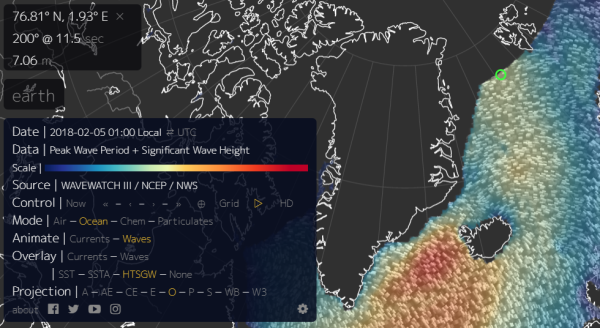
During this time, a powerful 950 to 960 mb low is expected to develop over Baffin Bay. Hurling hurricane force gusts running from the south and digging deep across the North Atlantic, Barents, and Arctic Ocean, the low is projected to drive a knife of 50-60 F above average temperatures toward the North Pole by February 5th.

(20-25 foot surf heading for the increasingly fragile sea ice in this February 4 wave model forecast. Note the 30-40 foot waves off Iceland and associated with the same storm system that is predicted to bring above freezing temperatures to the North Pole on February 5th. Image source: Earth Nullschool.)

These warm winds are predicted to bring above freezing temperatures to areas that typically see -20 to -30 F readings in February. They are expected to rage over a sea ice pack that is at record low levels. And if the storm emerges, it will hammer that same dwindling ice pack with 20 to 25 foot or higher surf.

Fragile Arctic Sea Ice Faces a Hammering

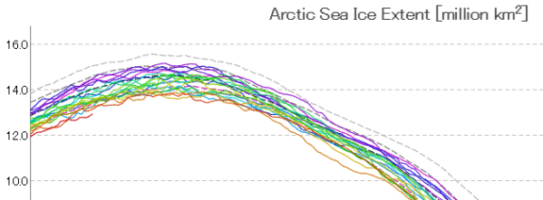
Presently, Arctic sea ice extent is trending about 200,000 square kilometers below record lows set just last year for the period of late February. And recent scientific research indicates that warm winter storms like the one that is now predicted to form can have a detrimental impact on sea ice.

(Arctic sea ice extent is presently at around 13 million square kilometers [bottom red line] — a new record low for this time of year. It should be around 15 million square kilometers and would be if the world hadn’t warmed considerably since the 1980s. Image source: JAXA.)

Not only do the storms bring warmer temperatures with them — a kind of heat wave that interrupts the typical period of winter freezing — they also drive heavy surf into a thinner and weaker ice pack. The surf, drawn up from the south churns warmer water up from the ocean depths. And the net effect can dissolve or weaken large sections of ice.

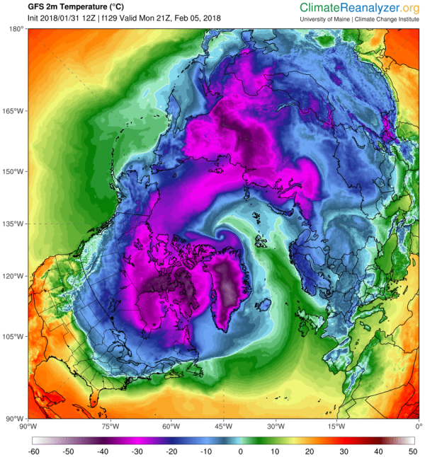
The presently developing event is expected to begin to take shape on February 4th, with warm gale and hurricane force winds driving above freezing temperatures near or over the North Pole on February 4th – 6th. To say that such an event, should it occur, would be practically unprecedented is the common understatement of our time. In other words, this is not typical winter weather for the North Pole. It is instead something we would expect to see from a global climate that is rapidly warming and undergoing serious systemic changes.

(February 5 GFS model run shows above freezing temperatures crossing the North Pole. Temperatures in this range are between 50 and 60 degrees [F] above average for this time of year. If the extremely warm cyclone event occurs as predicted, it will be a clear record-breaker. It will also further harm Arctic sea ice levels that are already in record low ranges. Image source: Climate Reanalyzer.)

Extreme Cyclone Beneath an Extreme Jet Stream

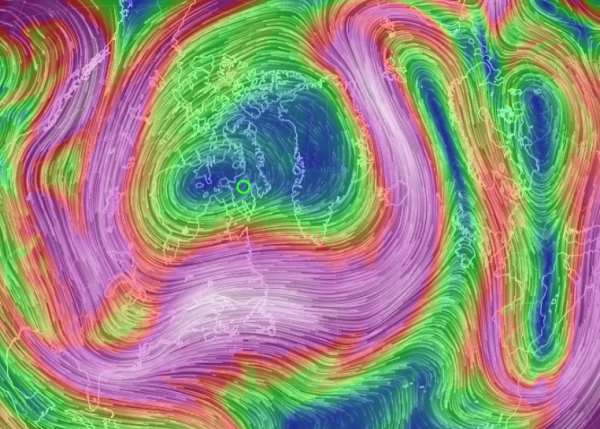
In the predicted forecast we see more of the extreme jet stream waves that Dr. Jennifer Francis predicted as an upshot of human-forced polar amplification (a condition where the poles warm faster than the rest of the globe under a larger warming regime). The particular wave in question for the present forecast involves a high amplitude ridge running very far to the north over Svalbard and knifing on into the high Arctic. The facing trough over Baffin Bay, Greenland, and North America is also quite pronounced and elongated. A feature that appears to want to become a cut off bubble of displaced polar air in a number of the model forecasts.

High amplitude Jet Stream waves during Northern Hemisphere winter as a signature of global warming are predicted by Francis and others to generate greater temperature and precipitation extremes in the middle latitudes. They are a feature of the kind of stuck and/or upside down weather we’ve been experiencing lately where temperatures in the Northeast have been periodically colder than typically frigid locations in Alaska. These flash freezes have, at times, faded back into odd balmy days in the 50s and 60s (F) before plunging back into cold. But the overall pattern appears to get stuck this way for extended periods of time.

(Very high amplitude ridge and trough pattern at the Jet Stream level of the circumpolar winds is thought by a number of scientists to be a feature of human caused global warming. One that is related to polar amplification in the Arctic. Image source: Earth Nullschool.)

Heat in the Arctic is driving sections of cold air south even as warm air invades through places like Alaska, Northeast Siberia, and the Barents Sea. But the main variables of this story are global heat, global warming, fixed extreme temperature and precipitation patterns, and warm air invasion. The winnowing streamers of cold air driven out over places like the U.S. Northeast are just a side effect of the overall warming trend. One that is starkly apparent in the very odd western warmth that has grown more and more entrenched with each passing year.

For Now, It’s Still Just a Forecast

As with any five day forecast, we can take this one with more than just a grain of salt at the present time. But such an extreme event is entirely possible during the present age of human-forced climate change. During late December of 2015, we identified a predicted major storm that ultimately drove North Pole temperatures to above freezing. At the time, that storm was considered unusual if not unprecedented. However, since February is typically a colder period for the North Pole region, a warm storm drawing above freezing air into that zone would be even more unusual. It would also be a feature of the larger trend of loss of typical seasonal winter weather that we’ve been experiencing for some time now.

5 FEB UPDATE: Storm and Heat a Bit Further South and East Than Predicted

A powerful warm storm in the 952 mb range did form and track across Greenland to exit over the Greenland Strait earlier today. The storm drove warm air far north, pushing above freezing temperatures past Svalbard and over the dark and frozen sea ice. It hurled gale force winds, hurricane gusts, and massive swells into the ice. But it did not push temperatures to above freezing at the North Pole as some models had earlier predicted.

(Warm cyclone hurls much warmer than normal temperatures across the Barents Sea and Arctic Ocean on 5 Feb, 2018. Image source: Earth Nullschool.)

It did, however crank temperature there up to -4.3 C or about 26 C above average for this time of year.

The storm is now predicted to drive above freezing temperatures across the Barents Sea, over Novaya Zemlya, through the Kara Sea and ultimately into Northern Siberia over the next 24-48 hours. In numerous regions, temperatures are already hitting near 30 C (54 F) above average. This extremely warm spike relative to typical conditions — associated with a high amplitude Jet Stream wave and related cyclone — will continue to ripple through the Arctic over the next few days.

Overall, total Arctic region temperature anomalies are predicted to range from 2.5 to 3.5 C above the 30 year average for the next few days. These are very warm departures. But not so warm as recent spikes in the range of 4 to 5 C above average for the region. In addition, there appears to be a tendency for powerful warm storms to continue to develop near Svalbard in the longer 5-15 day model runs. So the North Pole isn’t out of the woods yet for potential above freezing temperatures this February.

This is the Climate Pattern Scientists Warned Us About — Wildfires Approach 8 Million Acres in U.S. During Summer of Extreme Western Heat, Severe Eastern Storms

“If the same weather persists for weeks on end in one region, then sunny days can turn into a serious heat wave and drought, and lasting rains can lead to flooding.” — Dr. Stefan Rahmstorf.

“The warming of the Arctic, the polar amplification of warming, plays a key role here. The surface and lower atmosphere are warming more in the Arctic than anywhere else on the globe. That pattern projects onto the very temperature gradient profile that we identify as supporting atmospheric waveguide conditions.”Dr. Michael Mann.

******

To say that, for the U.S., it’s been hot out west and stormy in the east this summer is a bit of an understatement. For while the east has seen numerous storms producing local-to-national record rainfall amounts, the west has been baking under heatwaves that appear to have set off one of the worst years for wildfires nationally on record. This is an extreme summer weather pattern that recent scientific studies have linked to human-caused climate change.

(Severe western wildfires blanket northern U.S. under a massive plume of smoke. Image source: NASA Worldview.)

Last week, extreme heat baked the U.S. west coast. On Friday, San Francisco hit a record high of 106 degrees (F), striking up to 102 (F) on Saturday. Regions further inland near Eureka hit a Death Valley-like 115 F.  36 million Californians fell under a heat advisory as excessive heat warnings ranged on up the west coast through Oregon, Washington, and British Columbia.

The heat wave — which was just the most recent of many for the region this year — baked hills and valleys covered with new vegetation springing up after unusually heavy winter rains. Setting off a spree of wildfires that has seen very severe burn rates throughout summer.

Los Angeles County in Burbank experienced its largest fire on record Saturday as a massive blaze swept through the hills — igniting 7,000 acres before being tamped down by the oddly northward tracking remnants of a tropical storm drifting through the region on Sunday.

The fire spurred the response of 1,000 firefighters, forced 700 people to evacuate, closed route 210 for a time and consumed three homes. Assisted by the rains and moisture flowing off the remnants of Lidia, firefighters have now managed to contain 30 percent of this particular blaze. But with many more fires continuing to burn throughout the west, the region is far from out of the proverbial woods.

According to the National Interagency Fire Center, 70 large fires continue to burn in the western states of Montana, California, Oregon, and Washington. The vast majority of these fires remain uncontained. And at least two exceed 100,000 acres in size. Smoke from these fires has been cycling into the upper level winds for some time now — with most of the northern U.S. falling under a high altitude smoke plume (see top image above).

In total, more than 7,800,000 acres have burned so far in the U.S. this year. This represents the second worst fire year on record so far compared to the last ten years and may ultimately beat out 2006 as the second worst fire year ever recorded. By end 2006, 9 million total acres had burned. During the worst fire year for the U.S. — 2015 — 11 million acres burned in total. By this time during 2015, nearly 9 million acres had been consumed compared to 2017’s present total near 8 million acres.

These fires are occurring primarily in the west where a persistent high amplitude ridge in the Jet Stream has formed. This ridge keeps enabling heatwaves to bake the region and spike fire dangers. And it’s a weather feature that some scientists are saying is linked to human-caused climate change — which is causing the Arctic to warm, while pulling meridional south-to-north upper level winds into the polar zone and producing a wavier jet stream during extreme weather patterns.

(A study produced by a team of scientists including Dr. Michael Mann in March linked extreme summer weather patterns to polar warming and a wavier jet stream.)

The net effect is to create a kind of Halo of Storms and Heatwaves over the middle and upper latitude regions of the world. Earlier this year, The Scientific American noted:

What we think happens is that when there is a ridge forming in a location where Arctic warming can intensify it, that makes the ridge strong and builds it even farther northward. It creates an even bigger wave in the jet stream. You get a stronger ridge over western North America and a stronger southward dip that is farther toward eastern North America.

A subsequent scientific study lead by Dr. Michael Mann and presented in March of this year found that:

… analysis of both historical model simulations and observational surface temperature data, strongly suggests that anthropogenic warming is impacting the zonal mean temperature profile in a manner conducive to wave resonance and a consequent increase in persistent weather extremes in the boreal summer.

And this is exactly what we’ve seen over the U.S. this summer. A stronger than normal ridge in the west fueling record heatwaves and wildfires and a stronger than normal trough in the east fueling more extreme storms. This is a pattern of juxtapposed extremes. One that appears to be fueled by climate change related factors.

Links:

NASA Worldview

National Interagency Fire Center

Largest Wildfire in Los Angeles History Burns Amid Record-Setting Heat

The Arctic is Getting Crazy

Extreme Weather Events Linked to Climate Change’s Influence on the Jet Stream

A Halo of Storms and Heatwaves

Unprecedented Jet Stream Wave Sparks 120+ Degree Temps in the US Southwest and Tundra Fires in Extreme Northern Canada.

Canadian Tundra Fires June 29

(Tundra Fires Near Hudson Bay in Northern Canada on June 29, 2013. Image source: Lance-Modis)

Today, as temperatures rocketed to above 120 in the US Desert Southwest, temperatures hit 87 degrees on the shore of the frozen waters of the Canadian Archipelago. These were the south to north markers of a heatwave that spanned 3,000 miles from Death Valley, California to Cambridge Bay in extreme northern Canada.

Beneath the southern section of this vast and sprawling heat dome, US communities coped by setting up cooling centers and issuing heat warnings. But despite this agile preparedness, hospitals in the hardest hit areas were flooded with cases of heat injury.

In one instance, an outdoor concert in Las Vegas saw more than 200 persons treated for heat injuries while more than 36 were hospitalized. Sadly, an elderly man also passed away at one local hospital after suffering from heat stroke. Temperatures reached an extraordinarily hot 115 (Fahrenheit) in Sin City.

Elsewhere, across the region, Palm Springs hit 122, Death Valley hit 125, and Phoenix hit a scorching 119. Tomorrow is expected to bring another day of extreme record heat, so area cities and residents are still under the gun.

Further north, near 90 degree temperatures stretched all the way to the frozen shores of Cambridge Bay in extreme northern Canada. There, some locations on the ice choked waterway experienced 87 degree temperatures, which is nearly 40 degrees (Fahrenheit) above average for this time of year.

The extreme heat sparked numerous tundra fires across Northern Canada, some of which you can see in the NASA satellite image above. Note the smoke tails rising from two clusters of fires in the upper center portion of the image. That ice speckled area of blue to the right is the, usually frigid, Hudson Bay.

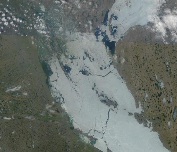
The heat also set off melt and fracturing of sea ice in Cambridge Bay, which you can see in the NASA shot below:

Ice melt Cambridge Bay June 29

(June 29 Ice Melt and Fracturing, Cambridge Bay. Image source: Lance-Modis)

Warming air temperatures typical for this region (high 40s to low 50s) usually result in a more gradual melt. But hot air temperatures at up to 55 degrees (Fahrenheit) above freezing tend to have a far more rapid effect. It is also worth noting the nearly complete lack of visible snow cover in this extreme northern region.

I’ve Never Seen A Rossby Wave Like This

The cause of this 3000 mile swath of heat is an extremely high amplitude wave in the Jet Stream that stretches from the Western US all the way up to the Arctic Ocean. This large bulge has allowed a powerful ‘heat dome’ high pressure system to build up beneath it, concentrating heat over the vast area affected.

Epic Rossby Wave June 30

(Image source: California Regional Weather Office)

Note the up-flow of Jet Stream winds rising up the coast of California, Oregon, Washington and British Columbia then lifting all the way up to the Arctic Ocean before diving back down through central Hudson Bay and into the US Midwest, before making another hairpin turn north again over the Appalachians.

Large Jet Stream waves of this kind are termed ‘Rossby Waves’ after the climate scientist who first identified them. They show extreme north-south and south-north elongation. In the time I’ve been tracking the extreme changes to the Northern Hemisphere Jet Stream brought about by human-caused warming, I’ve never seen a Rossby Wave quite so large as this. Nor have I seen one that is the result of so many large back and forth meanders. In fact, the entire Northern Hemisphere Jet is a mess of meanders, cut off upper level lows and blocking highs.

One of these upper level lows is expected to bring abnormally heavy rain with up to 3-5 inches for some parts of the US East Coast over the next couple of days. So as heat bakes a swath from Death Valley to the Arctic Ocean, the Eastern US braces for potential flooding. Similar Jet Stream loops and swirls spawned the European floods this June, a series of deadly floods that killed hundreds in India and Tibet, and multiple anomalous Arctic heatwaves occurring throughout the past month.

Extreme Jet Streams, like the one displayed above (for late Saturday, June 29), are far more likely to spawn extreme weather events than the usual, gently wavy Jet Stream that human civilization has been used to for much of the 20th Century and, probably, for most of the 10,000 year period since the last ice age. But a combination of eroding sea ice and record or near record low Northern Hemisphere snow cover contribute to both a slowing of the Jet Stream and in greater north-south and south-north flows. The result is large wave patterns in the Jet that tend to get stuck in the same configuration for long periods. Beneath the swells in the Jet, we get hotter temperatures, dryer conditions, and the risk of everything from extreme heatwaves to droughts and fires. In the dips, we get cooler temperatures and much, much stormier conditions resulting in a range of weather from extreme winters (Europe during winter/spring 2013), to floods (Europe summer 2013, India late June 2013), to record rainfall and powerful thunderstorms (US May-June 2013).

These are vivid examples of how human-caused climate change can result in extreme weather.

Heat Wave to Last For at Least a Week

The current record heat wave affecting both the US West and a large section of Canada is expected to last at least until the end of this week. Slow moderation, though, is expected for some regions after Sunday. However, the blocking pattern that spawned this particular heat wave shows little sign of changing position. So hotter, dryer conditions are expected to remain in place for the foreseeable future for much of the US South-West.

Meanwhile, Canada and regions along the Arctic coastline are still likely to see much warmer than usual conditions as periodic warm air invasions from the south are likely to continue.

Links:

Lance-Modis

California Regional Weather Office

Punishing Heat Hits Western US


Arctic Heatwave Sizzles Northeastern Europe With 92 Degree Temperatures, Mangled Jet Stream Hosts Record Canadian Floods, and the Persistent Arctic Cyclone is Coring Through the North Pole

It’s your typical abnormal summer day in the Arctic. The Arctic heatwave flares again, Canada tries to recover from violent record floods, and a Persistent Arctic Cyclone that began in late May is continuing to core a hole through the sea ice near the North Pole.

The Arctic Heatwave Moves to Eastern Europe

An Arctic heatwave that has skipped from Scandinavia to Alaska to Central Siberia, pushing temperatures in this polar region into the 80s and 90s (Fahrenheit), has now re-emerged to plague Eastern Europe. Temperatures in the middle 80s are once again emerging in Finland, an area that blazed with anomalous 80 degree temperatures in early June. But areas north of the Arctic Circle in nearby Russia are, this time, receiving the real baking. There, highs in the region of Archangel, near the Arctic Ocean, reached 92 degrees Fahrenheit. Out over the Kara Sea, just north of these record-hot conditions, an area still choked with sea ice experienced near 70 degree temperatures today.

Average temperatures for most of these regions range from the 40s to the 60s. So current conditions are about 20 to, in some cases, nearly 30 degrees above average.

Arctic Heatwave June 24

(Image source: Uni Koeln)

In the above weather map, provided by Uni Koeln, we can see today’s record high temperatures showing up in pink in the lower right-hand corner of the map. Note the instances of 32 and even 34 degree Celsius temperatures (which converts to 90 and 92 degrees Fahrenheit respectively).

We can also see that some of last week’s fires over Siberia, which I described here, have been put out by a massive rainstorm now dousing the region. The storm emerged as a trough surged down from the Arctic and over Siberia, setting off large storms.

Extreme Jet Stream Sets Off Floods in Canada, Forcing 100,000 to Evacuate

During the middle of last week, the convergence of two upper-level flows of the Jet Stream set off very unstable conditions over Alberta, Canada. A cut-off upper level low stalled, trapped beneath a long-period blocking pattern and dumped rain on Alberta and regions of Central Canada from Wednesday through Monday. Consistent moderate-to-heavy rainfall fell in some areas for up to 16 hours without stop. By the weekend, many places had set one day records as a swath of 2 to 7 inch rainfall blanketed a broad region. Many areas, including Calgary, received their highest rainfall totals ever recorded.

Contributing to the problem was hard, frozen ground and ongoing mountain melt filling up streams and rivers. This combination of impenetrable ground, snow melt, and ongoing, record rainfall resulted in massive floods that turned streams into torrents, roads into rapids, and stadiums into lakes. In total, more than 100,000 people were forced to abandon their homes.

This particular event is likely to see damages well in excess of 1 billion dollars and could rival the record 22 billion dollar floods that rocked Europe just last month. Jeff Masters, at WeatherUnderGround, speculates that the 2013 Canadian floods may be the most costly in that country’s history. Given the massive impact of this major flood, damage totals may exceed previous record flood impacts, at around 800 million, by well more than an order of magnitude.

Persistent Arctic Cyclone Cutting Through the Central Sea Ice

PAC 2013 June 24

(Image source: DMI)

Lastly, a Persistent Arctic Cyclone that began in late May, and has now composed numerous storms remaining in place over the Central Arctic for about a month, continues to cut a hole into the sea ice near the North Pole. The above image, provided by DMI, shows PAC composed of an old low near the Canadian Archipelago and a new, stronger low that just entered the Central Arctic.

Lowest pressures are now about 990 mb, which is somewhat stronger than the storm that lingered over the Arctic this weekend.

Impacts to central sea ice appear to be ongoing even as somewhat rapid edge melt continues. The latest model assessment and forecast from the US Navy shows a widening and thinning area of broken ice near the North Pole, one that displays much greater losses than those seen earlier in the month. A band of open or nearly open water has now emerged just on the Russian side of the 180 degree East line. As you can see, model forecasts show this area of open water continuing to widen over this coming week.

PAC2013modelforecastJul1

(Image source: US Navy)

Meanwhile, some of the thickest sea ice is also showing the corrosive impacts of these ongoing storms. In the image above, you can clearly see the invasion of ice thinner than 2 meters where 2.5, 3, and 3.5 meter ice previously dominated. In fact, in later sequences, it appears that a knife of much thinner ice begins to drive down through the relatively small pack of remaining thick ice.

The Central Arctic is extraordinarily cloudy today. So it is not possible to verify these Navy observations with visual shots. That said, the Navy projections have been both consistent and confirmed in the other monitors since early-to-mid June.

****

Any one of these extreme weather events — a heatwave in Arctic Europe, immense floods never before seen in Canada, and an anomalous storm coring through the thickest sea ice — would be evidence that human caused climate change has radically altered the weather. Instead, we have all three occurring over the span of as many days. It is a pace of extreme events that is both troubling and astounding. And each has been affected by the sea ice loss, ocean, ice sheet, and atmospheric warming, loss of summer snow cover, and extreme changes to the circum-polar Jet Stream brought about by human caused climate change.

We are in the age of extreme weather brought on by our fossil fuel use. If we are to have any hope of preventing the very worst impacts, we need to drastically begin reducing CO2 and related greenhouse gas emissions as soon as possible.

Links:

Calgary Flood May be Most Expensive In Canadian History

Uni Koeln

DMI

US Navy