If it seems we are doing a never-ending marathon of hottest posts, it’s simply because the world right now is ridiculously hot. Hotter than at any time ever seen before and being driven inexorably hotter by a combination of human greenhouse gas emissions and what appears to be a global warming weirdified El Nino that doesn’t look anything like a normal El Nino, but instead shows up as an intense blob of extreme heat sitting in a massive hot blob that makes up pretty much all of the Pacific Ocean from the Equator on north.
Busting the Top of the Global Temperature Graph
It’s in this rather crazy weather context that we find, according to NASA, October of 2015 set the bar for new hottest month in the global climate record for all of the past 135 years. That’s right, out of 1618 months in NASA’s global climate record, when comparing current readings to rolling baseline temperature averages, October of 2015 was the hottest one ever seen. A confirmation of the Japan Meteorological Agency’s findings from earlier this week. But one that, in true NASA fashion, also provides a boatload of additional data worth peeping at.

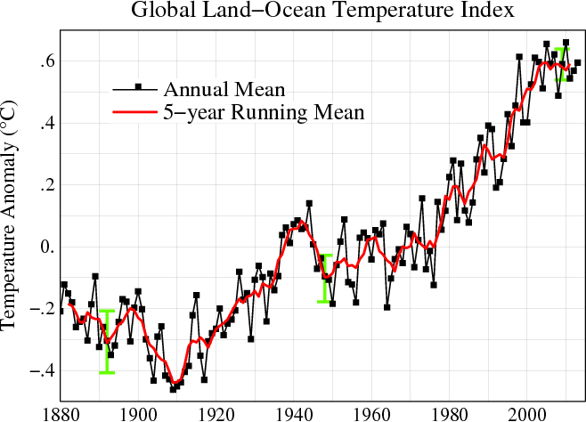
(With one month remaining in the December-through-November climate year, global temperature averages for the first 11 months of 2015 are now +0.819 C above the 1950-1981 NASA baseline. With November also likely to come in between +0.90 and +1.1 C hotter than normal, the 2015 yearly average is likely to come in well above the top of the chart. Image source: NASA GISS.)
Taking a glimpse at NASA’s Land-Ocean Temperature Index (LOTI), we find that October of 2015 came in at an extraordinary +1.04 C hotter than the 1950 to 1981 average or about 1.26 C hotter than 1880s averages. That’s an extreme temperature departure hitting within 0.74 C of the so-called safe limit of 2 C warming set by the UN. To put into perspective how weird and scary it is to hit such a high temperature departure, the last time temperatures were so high globally for any period of note, sea levels were between 10 and 30 feet higher than they are today. It’s another unfortunate passing of another bad climate marker on the way toward worse and worse to come if we can’t manage to stop emitting so much carbon into the atmosphere.
Overall, October of 2015 beat out the previous record hot month of January of 2007 (0.97 C above the NASA baseline) by 0.07 C. It is also the first month in the NASA monitor to exceed 1 C above the mid-to-late 20th Century range. In total, all of the top five hottest months in the global climate record have now occurred since 2007 with October 2015 (+1.04 C) coming in as hottest, January of 2007 (+0.97 C) coming in as second hottest, March of 2010 (+0.93 C) third hottest, March of 2015 (+0.90 C) fourth hottest, and September of 2014 (+0.89 C) as fifth hottest. But with the monster El Niño blowing up in the Pacific and with atmospheric greenhouse gasses pushing above 400 ppm CO2, it’s likely that many of these top five months could be replaced by new records into early next year. Moreover, the three month period of September, October, and November of 2015 now looks like it will be the first quarter year to exceed +0.9 C above the 1950-1981 baseline in the NASA record.
Warm Equator, Heating Poles
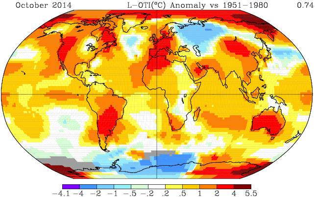
Moving on to NASA’s geospatial temperature anomalies map for the month of October, we see that much of the abnormal heat remains centered at the Poles. This despite a Godzilla El Nino belching hot air into the Equatorial region and pushing a strongly positive Arctic Oscillation. High polar temperature anomalies are an odd result during powerful El Nino periods due to the fact that warming at the Equator tends to strengthen the Polar wind field, locking cold into the upper and lower Latitudes. But over the past two months, Polar temperatures have remained extremely high despite what looks like the most powerful El Nino ever recorded tearing its way through the Pacific.

(This is what a record hot world looks like in NASA’s global temperature anomalies map. Note both the heat at the Poles and Equator along with the melt and ocean heat uptake related cool pools in the North Atlantic and Southern Ocean. Image source: NASA GISS.)
With such high polar temperatures giving what amounts to an atmospheric back-hand to the strongest El Nino on record, it’s a sign that a raging greenhouse gas driven polar amplification is becoming ever more heavily entrenched. The poles, in short, are more sensitive to global temperature swings and tend to amplify any overall warming or cooling trend. Such an additional sensitivity is due to a number of unique feedbacks that come into play in the upper Latitudes as greenhouse gas levels and global temperatures rise or fall. A circumstance that was predicted in even the earliest global climate model runs forecasting the impacts of a human forced heating of the Earth System. And it appears that this feedback-generated added warming is starting to take hold with a vengeance.
Overall, we find the highest temperature deltas in the Arctic Ocean just north of the Kara Sea, over various regions of the far South Antarctic, and over Central and Western Australia. These regions ranged into an extreme +4 to +5.1 C positive anomaly for the month. Broader warm regions featuring +2 to +4 C above average temperatures surrounded these hot zones. Strong warm temperature departures in this range also held sway over the Eastern Equatorial Pacific El Nino hot spot, over a band from North Africa through the Middle East, over the Lake Baikal region of Russia, and over South Africa.
Equator-to-Pole heat transport — another feature we really don’t like seeing — also remained plainly visible in the October NASA anomalies graphic. Two slots of warm air transport into the northern polar zone show up clear as day in the above graphic — one maintaining over Western North America and another holding sway over Northeastern Asia.
Somewhat cool regions include the heat sink zone in the Southern Ocean, the tip of South America, Eastern Europe, and the ominous Greenland melt related cool pool in the North Atlantic (something we also really don’t want to see). Overall, most of the world showed above average readings with cooler regions increasingly isolated on the NASA map.

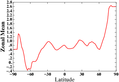
(Zonal anomalies map shows a strong polar amplification despite El Nino. Image source: NASA GISS)
At last coming to the zonal anomalies graphic, we again observe a very strong polar amplification for the month of October. Here we note that the highest global temperature anomalies occur at both the South and North Poles. These extreme temperature spikes in the range of +3.3 to +3.5 C above average for the month are plainly visible in the upward tilting ‘devils horns’ (another unfortunate climate change indicator) at both the left and right border of the graph. As we move toward lower Latitudes, temperature departures rapidly fall off into the global cool and stormy zones between 50 and 60 North and South Latitudes. Anomalies then steadily climb to an El Nino-warmed Equatorial region (+1.2 to +1.4 C).
November of 2015 Also Likely to Test New Records
Looking toward November, early indications are that both the record or near-record global surface temperatures and the tendency for polar amplification continue. Land and ocean temperatures appear to have extended their October jump into new record ranges. El Nino, which under the regime of human-forced warming has often nudged global temperatures toward ever-hotter extremes, likely pushed sea surface temperatures to new all-time highs in the Equatorial Pacific for the month. Such a huge amount of heat bleeding off this broad ocean zone will likely to continue to spike global surface temperatures. Given such a context, it appears that we’ll be under the gun for new global surface temperature records for a period of at least the next 4 months. So what we saw during October was almost certainly just the start of the current global temperature spike.
Links:
NASA GISS Surface Temperature Analysis
NASA Land Ocean Temperature Index
October of 2015 Shaping up to be Hottest Month Ever Recorded