Permafrost Thaw Triggers Anthrax Outbreak, Wrecks Roads, Generates Carbon-Spewing Peat Primed to Burn in the Heat of Human Warming

About 75 years ago, a reindeer fell sick to anthrax. Laying down to die upon the frozen ground of Siberia, the poor creature’s carcass froze in the Arctic climate. With it, the deadly infectious bacteria teeming in the deer’s body were stilled into an inert latency.

In the decades after, billions of tons of carbon bellowed out into the world’s air from fossil-fuel burning and carbon-spewing machines spreading around the globe. The heat-trapping properties of these carbon gasses subsequently warmed the Arctic and the frozen permafrost that was this ill-fated deer’s — and the anthrax’s — tomb.

Extent of Permafrost NSIDC

(Extent of Northern Hemisphere permafrost. Due to human-forced climate change, this permafrost zone is starting to thaw. At about 2 C worth of warming, a majority of this region will be under thaw pressure. Thawing permafrost releases carbon dioxide and methane, unearths ancient diseases, and causes the ground overlaying the permafrost to collapse. Image source: NSIDC and Google Earth.)

For the deer, there would be no second life, as rising temperatures bring decomposition 75 years after its death. But as the flesh of that deer warmed, the long-frozen anthrax bacteria began to revive. Over the past week, this climate-change-released anthrax spread back into the deer population, killing about 2,300 reindeer. It also leapt into humans, resulting in dozens of hospitalizations, with half the victims as children — and so far, one human death.

The Permafrost Tomb Opens to Release Undead Microbes

Permafrost, when boiled down to its basics, is primarily composed of frozen dead things. Much of the material is leaf litter, grass, wood, bark, flowers, or other frozen plant matter. But interspersed among what amounts to a many-meters-thick pile of frozen peat stretching for thousands of miles around the northern continental boundaries of our world, are millions and millions of entombed animal carcasses. Many of these are thousands of years old. Some have been there for almost two million years. And each of them may carry latent viruses or infectious bacteria.

Thawing Permafrost causes land to buckle and collapse

(Thawing permafrost causes the land to buckle and crack even as it releases ancient microbes long entombed in ice. Image source: NSIDC.)

Cold does not always kill these microbes, which are often resilient to harsh conditions. Viruses are famous for their ability to remain dormant in far-flung biological reservoirs for geological time periods. Meanwhile, bacteria are capable of sporification, the generation of a tough protective shell to ward off extreme conditions. As permafrost thaws due to human-forced climate change, these ancient, long-dormant pathogens can become active.

To this point, LiveScience states that:

Anthrax isn’t the only pathogen potentially biding its time in the permafrost. In 2015, researchers announced that a giant virus they’d discovered in the Siberian permafrost was still infectious — after 30,000 years. Fortunately, that virus infects only amoebas and isn’t dangerous to humans, but its existence raised concerns that deadlier pathogens such as smallpox, or unknown viruses thought extinct, might be lurking in permafrost.

Human activities such as oil drilling and mining in formerly frozen Siberia could disturb microbes that have been dormant for millennia (emphasis added).

As Bloomberg recently noted, the surprises coming from climate change can be similar to those hidden in a box of chocolates. But in this case, the nasty center happened to be anthrax.

Permafrost Thaw Crumples the Alaskan Highway

Thaw of the frozen, carbon-rich permafrost as the world is forced to warm not only poses an increasing risk for dangerous infectious disease outbreaks, it also results in weird changes to the land itself. Thaw causes permafrost to sag — sinking into pits, holes and bogs as the crystalline lattice of the old, melting ice collapses. Anything on top — be it buildings, highways, runways, animal paths, pipelines or telephone poles — can find its foundations undermined.

Such is the case with the Alaska Highway running from central Alaska southward through northwestern Canada. Constructed during World War II, this road has long been a critical 1,387-mile artery through which goods and traffic were delivered to the far north. With human-forced climate change causing the permafrost to thaw, the Highway and the communities it supports are in jeopardy. Every year, large cracks form in the road’s supporting structure — some of them wide enough for a grown man to walk in — as the permafrost beneath the road thaws and deflates.

Permafrost thaw causes roads to crack sag and buckle

(Permafrost thaw is causing northern roads like the Alaska Highway to crack, sag and buckle. Image source: NSIDC.)

Jeff Currey, materials engineer for the northern region of Alaska’s Department of Transportation, recently noted:

“The Romans built roads 2,000 years ago that people are still using. On the other hand, we have built roads that within a year or two, without any maintenance, look like a roller coaster because they are built over thaw-unstable permafrost.”

It now costs more than 50 million dollars every year just to maintain the Alaska Highway. That’s about seven times the average maintenance cost of a road of comparable length. Climate change’s impact on the permafrost is responsible for this increased cost. With so few roads running through the far north, the Alaska Highway is critical to the communities it feeds into. However, as climate change causes the road to break and buckle, the future stability of these communities is called into question.

About 1,800 Billion Tons of Flammable Carbon in the Thawing Permafrost

As if thawing, unearthing of disease-carrying carcasses, and sagging lands causing infrastructure to buckle and collapse weren’t enough, the permafrost itself contains enough carbon to significantly amplify human-forced warming. Some of this carbon will be released due to the process of warming-induced decay. In other cases, since much of that thawed permafrost is flammable peat-like material, direct burning becomes an even more rapid carbon-release mechanism. The vicious cycle can be summed up like this: warming = permafrost thaw = more fires = warming.

“You have this climate and fire interaction, and all of a sudden permafrost can thaw really rapidly,” Jon O’Donnell, an ecologist with the National Park Service’s Arctic Network, recently noted in Mother Jones.

In total, it’s estimated that between 1,300 and 1,600 billion tons of carbon is sequestered in just the top three meters of permafrost. Another 400 billion tons of carbon is estimated to be contained in the deep permafrost. To put these numbers in perspective, the atmosphere today holds about 850 billion tons of carbon. So if all the carbon in the permafrost were to hit the atmosphere as CO2, for example, we’d be sitting near 1,000 ppm of that heat-trapping gas, a truly catastrophic number. Thankfully, various inertia keep such a thing from happening all at once. Permafrost thaw takes time, and the process of transforming permafrost to atmospheric carbon does not occur instantly or completely even after the permafrost thaws. Nonetheless, the amount of heat-trapping gasses coming out of these thawing lands is expected to be significant.

As the Arctic is warming by about 0.6 degrees Celsius each decade, the permafrost thaws and some of the carbon that’s entombed there enters the Earth’s carbon cycle. This happens as the frozen lands heat up and are transformed into peat bogs or piles of dry, peat-like material. Methane and CO2 bubbles or wafts up from the newly-formed lakes and the decaying material below. The thawed peat starts to decay. If the decay is dry, then the carbon is released as CO2. If wet, it tends to release more as methane. At times, this gas blasts great holes in the surface or causes the topsoil and grass to ripple as a methane-filled blister rises beneath it. All that newly-thawed material becomes fuel added to the ever more numerous fires that continue to bloom and rage throughout the northern parts of the world.

Permafrost Burning

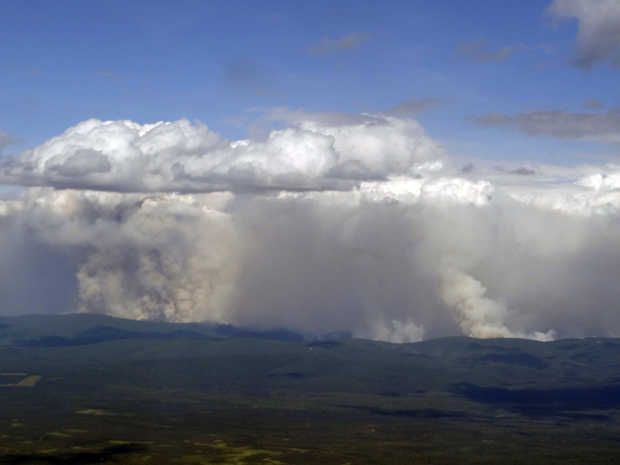
(Alaskan wildfire burns through a permafrost zone near a frozen river. Image source: National Park Service.)

In total, it’s estimated that around 160 billion tons of this carbon could hit the atmosphere by 2100. That would be like adding nearly two billion tons to the carbon emission from fossil-fuel burning every year. All told, such an emission would be enough to increase atmospheric CO2 concentrations by around 35-75 ppm (depending on the state of carbon sinks), if it all emitted as CO2.  The extra carbon in the air would then trap more heat, generating a self-reinforcing cycle that we call an amplifying feedback.

The frozen land therefore releases disease as it thaws, it crumbles infrastructure, and as it dries and melts and wettens and burns it releases still more heat-trapping gasses. All reasons why we should be very trepedacious about the now-thawing permafrost — embedded as it is with zombie anthrax — as well as the various and multiple other surprises human-forced climate change continues to serve up.

Links:

Anthrax Spewing Zombie Deer are The Least of Your Warming Planet Worries

NSIDC

The Alaskan Highway is Literally Melting

Alaska Sinks as Climate Change Thaws Permafrost

Climate Change and the Permafrost Carbon Feedback

The National Park Service

More Wildfires = More Warming = More Wildfires

5 Deadly Diseases Emerging From Global Warming

Hat tip to Colorado Bob (who has been warning about diseases due to thawing permafrost for some time now)

Hat tip to Greg

Hat tip to DT Lange

(UPDATED)

Canadian Fire Season Starts Far too Early as Fort St. John Residents are Forced to Flee the Flames

It’s been a ridiculously hot Winter and Spring for most of Western and Northern Canada. And in many locations, odd, Summer-like conditions are already starting to dominate. For these regions — areas sitting on piles of dry vegetation or thawing permafrost — a single hot day, thunderstorm, or even just the melting away of the Winter snow is now enough to spur the eruption of wildfires.

In Fort St. John, along the shores of Charlie Lake in Northeastern British Columbia and at about the same Latitude line as Ft. McMurray in Alberta, temperatures on Monday rocketed to 28 degrees Celsius (about 82 degrees Fahrenheit). These scorching readings were about 20 degrees C (36 degrees F) above average for the day. The excessive early-season heat sweltered an area that had seen extensive drying throughout a long, warm winter. And nearby grasses and crops became a ready fuel as Monday’s heat and winds sparked four sudden and severe blazes that swiftly leapt toward town.

Taylor Fire in Fort St John

(Taylor fire looms over fuel tanks on Monday evening. In total, excessive heat and dry conditions sparked 48 wildfires across Northern British Columbia on Monday — a number that had swelled to 53 by Wednesday morning. Image source: Destiny Ashdown/Facebook.)

By Monday evening, more than 48 fires had raged into existence throughout northeastern British Columbia — forcing the province to declare a state of emergency. By Wednesday morning, excess heat, thunderstorms and strong southerly winds had fanned a total of 96 wildfires across Canada.

In Fort St. John, two fires (The Taylor Fire and the Charlie Lake Fire) forced residents in the Baldonnel and Prince George communities to flee. The blazes cut power lines, generating outages for 2,700 customers, closed highway 29, consumed two homes, and threatened fuel storage tanks near Taylor. By early Wednesday (as of about two hours ago), these two fires had finally been contained and evacuation orders for Baldonnel and South Taylor were rescinded.

But as some fires came under control, other blazes swelled suddenly to more dangerous size. By Wednesday, the Beatton Airport Road Fire had grown to 4,500 hectares and a new evacuation alert had just been issued for that area. Meanwhile, the East Pine Fire, southwest of Fort St. John, had hit 500 acres even as it jumped the Pine River and continued to rage out of control.

Meanwhile, places along the thaw line in Northern Alberta began to erupt in plumes of smoke and flame.

Fire burning along the Freeze Thaw Line in Alberta April 19

(Satellite shot of fire burning along the freeze-thaw line in Northern Alberta on April 19th of 2016. During recent, and far warmer than normal, Northern Hemisphere Springs, Arctic wildfires have sprung up along thawing permafrost zones almost immediately after the snow line peels back. It appears that permafrost thaw provides a peat-like fuel that, in some places, continues to smolder throughout Winter, ready to erupt again during the increasingly early Spring thaw. A new Arctic fire hazard in a record hot world. Image source: LANCE MODIS.)

So as of April 18th, fire season had already begun in Canada. With record global heat stooping over the region, it’s a fire season that is likely to be very severe as some of the worlds’ swiftest rates of warming are adding a growing volume of potential fuels. Thawing permafrost in drought zones can become a peat-like fuel for fires sparked by recent excess heat and by the new lightning storms that are now starting to invade Canada’s central and northern tiers. Adding to the trouble is a great swath of vegetation lacking in much-needed fire resiliency due to the fact that most plants there have never had to deal with flames. It’s just a simple fact that a human-forced warming of the world has generated a new threat of burning that plants in Canadian provinces have never faced before.

The new Canadian fire season, the one that climate change is bringing on, now starts in April. And it will likely continue on through September of this year. Nearly a half year of wildfires burning in what should have been one of the coldest climate zones in the world. A place now wracked by dangerous and difficult changes. A place where billions of sparks will fly this year over one of the world’s greatest piles of sequestered carbon.

Links:

Early Wildfires Near Fort St. John Force Evacuations

Firefighters Make Progress on South Taylor and Charlie Lake Fires

Evacuation Alert Isuued for Beatton Airport Road Fire

City of Fort St. John Twitter Feed

Canadian Interagency Fire Center

Temperature Averages for Fort St John

LANCE MODIS

Hat tip to Andy in San Diego

Hat tip to Gordon Meacham


Alaska’s Epic 2015 Burning is One Month Ahead of Previous Worst Year; Canada Conflagration Continues, Eastern Siberia Wildfires Light Off

From Canada to Alaska to Siberia, an immense half-crescent of the Arctic is on fire. The hot spots along this zone include freakish fires with 50 mile fronts, fires that generate thunderstorms from the heat of their updrafts, and fires that paint smokescapes over the lake waters of Canada even as they light the sky red:

(Freakish lake fire burns in Saskatchewan, Canada on Monday, July 13. It’s just one of thousands of fires now raging through Arctic lands and 5,105 fires burning through Canada alone.)

Fires, overall, that have been vastly under-reported in the mainstream media. And, even when they are reported, they include often inaccurate qualifiers.

So what the heck is really going on? The human hothouse is generating an ever-greater burning potential throughout the Arctic. One that has erupted toward new levels of intensity this year. One that is plainly and painfully visible to any who care to look.

*   *   *   *   *

In Alaska, a massive area the size of one and one half Connecticuts (7,300 square miles) has already been consumed by fires. A zone of smoldering tundra, boreal forests turned to ash, smoking bogs, and smoldering, thawing permafrost.

But aside from a handful of responsible sources (see also here), the mainstream media just can’t get what is now likely to be the worst fire season ever to strike Alaska right. So let’s take a few moments to set the record straight on what is an unprecedented burning of Alaska’s warming tundra, forests and permafrost. A burning that is related to human greenhouse gas emissions-based heating of the atmosphere in that the thawing permafrost provides additional understory and methane fuels to fires even as it multiplies the number of fire-igniting lightning strikes.

A Failure to Accurately Report on an Ongoing Disaster Directly Linked to Humanity’s Greenhouse Gas Emissions

At first, a sudden, abnormal outbreak of hundreds of wildfires throughout the Arctic state during June was framed ‘not abnormal.’ That is until June shattered all previous records for worst wildfires ever and put all notions that anything normal was going on soundly to bed.

Next, the narrative ran on the false meme that most of the fires were caused by human hands (of the match tossing variety). Any journalist worth their salt, however, could simply check that pseudo factoid against the Alaska Interagency Coordination Center report to find that 377 fires were lightning-caused (well more than half) and that these lightning-caused fires, as of Tuesday, amounted to a whopping 4,675,000 acres burned. The human match, lighter, and campfire ignited fires? A piddly 30,000 acres. In other words, more than 99 percent of all the area burned was due to a warming-intensified proliferation of thunderstorm activity and related lightning strikes.

Alaska Pyrocumulous Clouds

(Pyrocumulus clouds have been popping up like hothouse amplifying daisies all over Alaska since mid June. This ridge fire appears to be in the process of building its own thunderstorm. Image source: ADN.)

Indirectly, we could certainly call this extra lightning human-caused — as the vehicle of greenhouse gas warming has resulted in a marked increase in lightning strikes to the thawing permafrost and heating forest and tundra fuels. But this particular human cause is certainly not of the typical match-throwing, arsonist variety. It’s another story entirely. A much more important story that far too many sources appear to be (unintentionally or deliberately) missing. A story of the plainly visible and worsening impacts of human-forced climate change.

To use any set of language other than to characterize the Alaska burning as unprecedented, freakish, record, and abnormal is vastly irresponsible. Any attempt to attribute the 4,675,000 acres ignited by warming induced lightning strikes to ‘arson’ is equally myopic and misleading. If you’re reading a source that makes these claims, that source is an invalid and untrustworthy reporting medium. One that can’t keep a handle on even the most basic of facts.

Alaska Burning is One Month Ahead of the Worst Fire Year Ever

And when all the dust of this mass misinformation over a critical issue directly related to human-caused climate change settles, we find that Alaska’s fires are now burning at a rate fully one month ahead of the previous all time record fire year of 2004. Tuesday’s total acres burned of 4,705,000 stood but 1,900,000 acres shy of that record. And at the current rate of burning, that total could be consumed within a mere 7-15 days — putting the current Alaska wildfire season, by late July or early August, at new record thresholds with more than a month left for forests, tundra and permafrost to continue to burn.

Alaska Wildfires July 14

(Hundreds mile long smoke plumes issuing from Wildfires in Alaska on July 14. Image source: LANCE-MODIS)

In the July 14 MODIS satellite shot we can clearly see massive smoke plumes billowing up from the still energetically burning fires in Central Alaska. Lightning laden cumulonimbus clouds ride overhead — a pattern refreshed by a continuous influx of warm storm moisture rising up over the Gulf of Alaska and deflected off the ridiculously resilient ridge (RRR) to the south. The storms are still setting off around 3-7 fires each day. A rate of new ignition that, though slower than June, is pushing total number of Alaska fires toward the unprecedented 700 line.

7.5 Million Acres Burn in Canada

Across the border in Canada a whopping 5,105 fires are now also consuming vast stretches of Arctic land. It’s an outbreak that resulted in the largest natural disaster evacuation in the history of Saskatchewan. One that has drawn firefighters from all over the world to combat an immense proliferation of blazes. Blazes that have burned about 7.45 million acres so far or an area about the size of 2.3 Connecticuts.

When combined with the Alaska fires, the total area now burned in Arctic sections of North America now equals about 12.1 million acres or more than 1 million acres burned since this time last week. Rates of burning for Canada are, like Alaska, in many cases unprecedented. Total acres burned for the Arctic nation are now at two times the five year average and three times the 25 year average. Specific regions, like British Columbia, are seeing as much as 10 to 20 times the typical area burned by mid July.

Vast Wildfire Eruption in Eastern Siberia

Moving on across the rapidly thinning ice of the Beaufort, Chukchi and East Siberian seas, we find that Eastern Siberia is also experiencing a massive wildfire outbreak. Reports from Russia on acres burned have tended to be spotty. But this zone near Lake Baikal has seen a persistent and then an expanding propagation of burn zones toward the north and east since April.

Vast burning in Eastern Siberia

(Vast swath burns through Eastern Siberia on Wednesday. Image source: LANCE-MODIS).

Today, the fire outbreak there could best be described as vast. Stretching from Lake Baikal to the Sea of Okhotsk, the fire zone now encompasses a region more than 1,000 miles across. Scores of large fires can be seen burning beneath a massive cloud of smoke that streams all the way down through China, combining with the nasty coal dust cloud stooping over that fossil fuel victimized state.

One cluster of these fires, visible in the upper left of the image frame above and zoomed in below features fires with fronts in excess of 50 miles long. These are truly immense fires. Individual blazes large enough to consume small states burning through the carbon rich boreal forests and permafrost zones:

Massive Siberian Wildfires

(Immense fires with fronts as long as 50 miles from end to end ballooned in Siberia today. Image source: LANCE-MODIS).

For reference, the above image’s lower frame edge covers more than 250 miles. This gives us a sense of the utterly huge fires burning away from lower right to center frame.

Conditions in Context — Human-Caused Warming Vastly Increases Arctic Wildfire Potential, Wildfires Make Climate Change Worse

The massive outbreaks of fires in Canada, Alaska and Eastern Siberia during 2015 are not occurring in a vacuum. They are not isolated disasters to simply report, confuse, forget, and then report again when the new record fires erupt in 2016, 2017, 2018 or 2019. They are instead symptoms of a larger trend of polar amplification in the Arctic.

The more than 1,400 billion tons of carbon in the permafrost is now being set to rapidly thaw. The permafrost, when unlocked from its primordial, thousands to millions year old, ice traps yields this carbon in solid, liquid, or gaseous form. The solid peats, the liquid organic carbons, and the methane seeps all provide new and highly volatile fuels for wildfires.

In addition, boreal forests are not fire resilient like their more southerly cousins. The trees there do not typically face flame or intense ignition sources. So when an atmosphere heated by human fossil fuel burning produces powerful, lightning flinging thunderstorms in the Arctic for the first time in thousands to millions of years, the trees there have no natural defense against the fires that inevitably ignite. Individual trees may as well be standing sticks of dynamite in the face of this warmth-driven barrage.

Other factors include tree killing pest invasions, the thin mat of flammable material that underlies most Arctic forests, and the drying tendency of the added heat itself.

So much forest, tundra soil and permafrost burning in the Arctic can eventually have its own sort of warming-amplifying effect. For the fires, fires that are likely not even natural to the slower periods of warming faced by Earth during past hothouse events, rapidly unlock the carbon stored in the forests as well as the rapidly thawing permafrost beneath. This release adds to the already extremely intense carbon emission from human beings and further heightens the danger of hitting climate points of no return.

This is the signal the media has lost in all its talk of ‘not abnormal’ and ‘arson.’ A warning cry from the Arctic. And one we had better not ignore.

Links:

Alaska Interagency Coordination Center

Canadian Interagency Fire Center

LANCE-MODIS

Alaska Wildfire Photos

Montreal Lake Wildfire at 250,000 Acres

Scary Statistics For Alaska Wildfire Season

Wildfires Set off Largest Evacuation in Saskatchewan History

How Climate Change Makes Wildfires Worse and How Wildfires Return the Favor

Hat Tip to Andy in San Diego

Hat Tip to Colorado Bob

Hat Tip to Alexander AC

Hat Tip to DT Lange

“Worst Fire Conditions On Record” — As Heatwaves, Drought Bake North American West, Wildfires Erupt From California to Alaska

There are 146 wildfires burning in Alaska today. A total that is likely to see at least another dozen blazes added to it by midnight. A total that has already absorbed the entire firefighting capacity of the State and has drawn hundreds of firefighters from across the country in places as far away as Pennsylvania.

For Alaska, it’s a case of record heat and dryness generating fuels for wildfires.

Alaska wildfires Sunday

(MODIS satellite shot of wildfires erupting over a sweltering Southwestern Alaska on Sunday, June 21. Wildfires in permafrost regions of the Arctic like Alaska are particularly concerning as they are one mechanism that returns ancient sequestered carbon to the Earth atmosphere. A sign of a feedback set off by human warming that will worsen with continued fossil fuel emissions. Image source: LANCE-MODIS.)

Deadhorse, at the center of North Slope oil fields above the Arctic Circle set an all time record high of 82 degrees Fahrenheit (28 Celsius) on Sunday. That’s 3 degrees hotter than the previous all time record high of 79 degrees (26 C) set on August 16, 2004. The hottest reading for June at that location was a 68 degree (20 C) measure set in 2007. So, basically, Deadhorse just shattered the all-time record for June by 14 degrees (F) and the globally record hot summer of 2015 has only now gotten started.

Other locations experiencing new records for just Sunday included Kotzebue, which set a new all time record highest low temperature of 62 degrees (17 C). This reading broke the previous all time high minimum mark of 56 degrees (14 C), set in 1987. Bethel and Yakutat both tied their daily high minimum temperature records at 54 and 52 degrees (12 and 11 C), respectively.

And yesterday was just one day in long period of record heat for the State. Last month’s NOAA analysis showed temperatures fully 7 degrees Fahrenheit (4 C) above average. It’s a record heating that is now setting off severe wildfires all over Alaska. According to the state’s Wildland Fire Information Center, the relentless heat and dryness has turned spruce, hardwoods, brush, and tundra into dry fuels vulnerable to any ignition source. Over the past week, ignition has come in the form of lightning — with most of Alaska’s 2015 wildfires set off by nature’s spark.

As a result we are seeing nearly double the number of fires during June compared to a typical year. Fires that have already destroyed 30 structures, forced evacuations, and tapped Alaska’s firefighting resources to its limits.

Wildfires Burning in the Rainforests of Washington as Major Heatwave Approaches

Record hot temperatures and wildfires, unfortunately, are not just an issue for Alaska. They’re a prevalent concern all up and down Western North America. A zone that has seen several years of record hot temperatures and dryness. Extreme weather events fueled by such global warming-linked phenomena as a Ridiculously Resilient high pressure Ridge over the Northeast Pacific that has kept heatwave and drought conditions firmly entrenched throughout much of the region for months and years. An atmospheric condition that is also linked to a hot ocean surface water ‘Blob’ in the Northeast Pacific (which is itself implicated in a growing number of marine species deaths).

Paradise-Fire-June-17

(Paradise Fire burning near a drought-shrunken creek in the rainforests of Olympia National Park, Washington. Image source: NPS and Wildfire Today.)

This week, the added heat also generated wildfires in unusual areas like the rainforests of Washington State’s Olympic Peninsula. Driest conditions since 1951 have resulted in a great deal of fire resiliency loss for forests in the region (1951 was the year of the historic Five Forks Fire, one of the worst ever to impact Washington State). Already, a rare early summer wildfire (called the Paradise Fire) has burned through 417 acres of forest.

Firefighters are doing their best to contain the blaze. But the record heat and dryness are multiplying fuel sources. Fires are enabled by dried lichens growing high up in the trees. When flames touch the lichens they rapidly ignite sending sparks to other lichen-covered tree tops. In this way, flames can leap rapidly from tree to tree under current conditions.

It’s very unusual to see fires in this rainforest zone. And when ignitions have occurred in those very rare cases, they have typically flared during late Summer and early Fall. So this June burning has fire officials very concerned — especially given the nearly unprecedented fire hazard conditions throughout the State. Conditions that are predicted to rapidly worsen as an extreme heatwave is expected to build through the coming weekend.

West Coast Heatwave Saturday

(A major heatwave is predicted to invade the US West and Northwest States this weekend. Washington and Oregon are predicted to experience temperatures more typical of desert sections of California and Arizona. Image source: Climate Reanalyzer.)

Temperatures over large stretches of Washington and Oregon are expected to climb into the 90s and 100s, possibly reaching the 110s (Fahrenheit — Celsius range from 33 to 45) by Sunday. For these typically cool, wet States, this brutal heat blow, should it emerge as predicted, will set off a spate of all time record high temperature readings, deepen drought conditions extending northward from California, and heighten fire conditions that are already in the range of worst ever experienced for sections of these States.

California Experiencing “Worst Fire Conditions On Record”

Moving further south along the U.S. West Coast we come at last to the drought hot zone that is California. A State that is now enduring its fourth year of drought. A drought that tree ring studies show is likely the worst such event in 1,000 years.

These harsh climate conditions were starkly highlighted this weekend as reports from State emergency planning officials now indicate that California is currently experiencing its worst fire conditions on record.

Ken Pimlott, Director of CAL FIRE noted:

We measure the fuel moisture content of all of the vegetation -the brush and the trees and we track that over the course of time and compare it month to month each year. And we put it through formulas and determine how much energy and how much heat it will put out when it’s burning. And we have seen -we saw it last year and we will see it again this year- we’ll be reaching records for potential heat output for times of the year that would normally not be burning in those conditions.

Wildfire nonexistent snowpack

(Large wildfire burns in forests along the slopes of Sierra Nevada Mountains whose peaks are now entirely devoid of snow cover. Note that remaining glaciers are shown turning a dull brown in the June 21 MODIS satellite shot.)

So far this year over 1,100 wildfires have already ignited throughout the State. That’s nearly twice the typical number of 650 blazes popping up by this time of year. Exacerbating this stark context is a state water resource crisis compounded by non-existent Sierra Nevada snowpacks and dead trees that now number in the millions.

This is not Normal, Nor Should We View Widespread, Related Events in Isolation

Record and unusual Alaska, Washington, and California wildfires this season are, thus, not occurring in isolation, but as an inseparable feature of ongoing climate trends related to human-caused global warming. In this case, heatwaves are related to visible and extreme record ocean and atmospheric temperatures that have been ramping both globally and in the regions affected over past years and decades. And the fact that 2015 is continuing as the hottest year on record globally should also not be viewed as separate from the events witnessed all up and down the North American West Coast. Events that were largely predicted in many global climate models assessing the impacts of human based greenhouse gas warming on this vital national and global region.

We’ll end here by considering this thought — it’s only June, yet up and down the North American West Coast we are experiencing some of the worst heat, drought, and fire conditions ever recorded. It’s only June…

*   *   *   *

UPDATE NOON EST, JUNE 23, 2015: Satellite Imagery confirms that, over the past 24-48 hours, the wildfire situation in Alaska has continued to worsen. Widespread and large fires running throughout southwestern, central, northeastern and eastern Alaska today expanded and multiplied:

Wildfires Alaska June 22

(Fires flared to dangerous size across Alaska on June 22nd and 23nd. Image source: LANCE-MODIS)

These rapidly proliferating fires cover a diagonal swath stretching about 800 miles from southwest to northeast across the state. The fires are burning through Alaska’s permafrost zone and current intensity in the satellite image is similar to some of the worst Arctic fires we’ve seen during recent years. A substantial number of these fires feature smoke footprints indicating 5-10 mile active burn fronts. Smoke plume size is now large enough to become caught up in the Jet Stream and impact visual features of skies across the Northern Hemisphere.

Based on these satellite shots, it appears that Alaska is experiencing a heightening and very severe fire emergency — one that shows little sign of abatement over the next few days.

Links:

Deadhorse Sets New All-Time Record High Temperature

NOAA Global Analysis May 2015

Alaska’s Wildland Fire Information Center

More Than 100 New Fires Spring Up Across Alaska

PA Firefighters Heading to Alaska to Battle Wildfires

Wildfires Burn in Olympic Rain Forest

Climate Reanalyzer

LANCE-MODIS

California Fire Says 2015 Fire Conditions are Worst on Record

Die-off of Millions of California Trees Centered in Sierra Nevada

Hat Tip to DT Lange

Hat Tip to Andy in San Diego

Permafrost Fires Advancing Toward Arctic Ocean Shores

Smoke from Siberian Tundra Fires August 1, 2014

(Smoke from Siberian permafrost fires entrained in wind pattern blowing over the East Siberian and Laptev seas. What can best be described as a synoptic pattern of smoke stretching for more than 2000 miles. For reference, we are looking at the heart of Siberia, the bottom edge of frame touches the Arctic Ocean. Total width of frame is more than 2000 miles. Image source: LANCE-MODIS.)

From the Northwest Territory of Canada to a broad central section of Russian Siberia called Yedoma, the permafrost fires this year have been vicious, powerful and colossal. They have burned deep into the basement soil and permafrost layer, casting out billows of dense, smokey material that, at times, has blanketed a majority of both Siberia and the North American Continent.

In Minnesota, two thousand miles away from the still raging Northwest Territory fires, James Cole, who comments here frequently, noted:

Forest fire smoke here in N.E. Minnesota was off the charts yesterday! I went out to watch the blazing red sun sink below the green hills. This almost invisible red ball brought back an old memory from watching a sun set in San Diego County during a very bad fire out break back when I was home ported with my ship there. These Alberta fires are a huge distance from here, but I can guess at their size by the thick gray haze, the smell and a sunset just like one in an active fire zone. (In confirmation to this eye-witness report, the Minnesota Star Tribune’s Meteorologist Paul Douglas reports Heat, Smoke, and Thunder)

Smoke Plume GOES

(GOES satellite shot of smoke plume from Arctic fires crossing Minnesota late yesterday evening. Image source: GOES.)

You can see the vast plume of filtering across Minnesota in the above GOES satellite shot.

Fires that Burn Soil

These fires aren’t anything normal. They burn the land as well as the trees. They cast off an inordinately high volume of smoke, such that they are far more visible in the satellite shot than more southerly fires of similar size. And they continue to burn for weeks and weeks — with lands that were lit nearly a month ago still casting off smoke and fire from the same locations.

The quantity of material necessary to keep such fires burning from the same location day in, day out, must be immense and it is becoming increasingly obvious to this observer that woodland as well as the soil and, likely, the thawing permafrost itself have become involved. It is a basement layer that, when fully thawed can be scores of feet deep. A set of peat-like material that, were it to be sequestered, would likely turn into a hundreds foot deep seam of coal over ages of heat and pressure. Instead, it is now being liberated as fuel for fires by human-caused warming.

Wildfire burning near Laptev Sea August 1, 2014

(Wildfire burning near Laptev Sea on August 1, 2014. The terrain in this region is tundra and tundra lakes, similar to the Yamal region where methane outburst sites where recently discovered. Wildfire is the comet like feature in upper center frame. The shoreline of the Laptev is visible along the lower frame border. Note the steely gray pallor of smoke running south to north [top to bottom] through the image frame. For reference, bottom edge of frame is about 150 miles, fire front is approximately three miles. Image source: LANCE-MODIS.)

On the Canadian side, the fires have primarily remained in the same region, simply continuing to burn from mostly the same sources or spreading only to local areas. But on the Russian side, the fires have leapt from their original cauldrons to ignite in massive blazes along regions both east and west, north and south.

Over recent days, fires have been creeping northward along a ridge line toward the Laptev Sea. Yesterday, a large fire ignited in the treeless tundra just 70 miles south of Arctic Ocean waters. You can see a close up image of this fire in the MODIS shot above.

So we have hard tundra burning just 70 miles south of the Arctic Ocean. No trees here, just an endless expanse of thawing ground.

Links:

LANCE-MODIS

Heat, Smoke, and Thunder

Hat tip to Colorado Bob (First Observation)

Hat tip to James Cole


Arctic Burning: 3/4 Mile Wide Fire Tornado Over Tetlin Junction, Alaska

(Hat tip to Peter Sinclair who thumbs his nose at the deniers stating, in reaction to this Fire Tornado: “sure, happens all the time.”)

The above is a film recorded on August 16th, 2013 of an explosive fire complex forming a massive fire and smoke tornado 3/4 of a mile across and towering thousands of feet into the air over a ridge line near Tetlin Junction Alaska. Close inspection of the video reveals trees and branches being sucked into the large fire ‘tornado’ caused by very strong inflow along the fire’s leading edge. Tim Whitesell, a firefighter at the scene noted:

“A picture probably is worth a thousand words, but there are indeed times when a picture just doesn’t do it justice. I’ve never seen anything like it until now.”

The terrain features in this region include boreal forest and soil that is mostly permafrost. The film shows both burning trees and ground along with a section involved in an episode of explosive outburst.

Reports from from The Alaska Fire Service are nothing short of stunning:

“This wildland fire footage was captured on August 16, 2013, on the southeast perimeter of the Tetlin Junction Ridge Fire (#414), burning east of Tok and Tetlin junctions, north of the Alaska Highway.

Fire behavior increased into the later part of the afternoon on August 16. At approximately 7:00 p.m., the Alaska Division of Forestry Aerial Supervision Module (consisting of Tim Whitesell and Doug Burts) reported the fire vortex to be about 3/4 of a mile wide; it lasted for about an hour. The extreme fire behavior uprooted trees, a scene that was captured by this footage- look for trees being blown around in the smoke column at the end of the clip.”

The blaze that sparked this massive fire tornado is arguably one of the smaller events to impact the Arctic this year, just a fraction of the size of larger infernos that have raged through areas of Canada and Russia since June. In ‘Russia Experiences Great Burning’ MODIS shots identified fire complexes and burn scars that covered 100 to 300 square miles or more (one fire burn scar measured a massive 30×70 miles). These events happened ‘off camera’ so there is no way to know if they also spawned very large fire tornadoes similar to the kind witnessed at Tetlin Ridge. What is clear from this fire and from fires across the Arctic this year and last is that the far north is burning like never before. As Russia’s eastern provinces experienced some of their worst flooding in 120 years, massive wildfires continued to burn even as the terrible rains and storm complexes advanced in an ominous Song of Flood and Fire. By now, the extent of Russian blazes has been somewhat lessened by these storms, although fire maps still show numerous active blazes.

A satellite picture of the blazing ridge-line on August 15 is given below.  The fire is located in the center of the image and spans about 5×10 miles of the affected ridge line. You can also see the burn scars of previous wildfires in the lands surrounding the August 15-16 blaze.

Tetlin Junction Fire Tornado

Tetlin Junction Fire Tornado

(Image source: NASA/Lance-Modis)

Thawing permafrost, warming forests, Arctic heatwaves and more energetic storms combine to provide massive volumes of warming fuel and increasingly powerful ignition events in the Arctic. Not only can trees burn, but the organic carbon stored in permafrost and sometimes bottled up as methane beneath the surface also provides fuel. In many cases, fires have burned three feet deep into what was the permafrost bed below consuming roots, stumps and soil.

Very large and energetic fire outbreaks have been increasing throughout the Arctic with recent years seeing some of the worst fires on record.

Links, Credits and Hat Tips:

The Alaska Fire Service

Climate Crocks

NASA/Lance-Modis

Colorado Bob

Robin Westenra