Alaska’s Epic 2015 Burning is One Month Ahead of Previous Worst Year; Canada Conflagration Continues, Eastern Siberia Wildfires Light Off

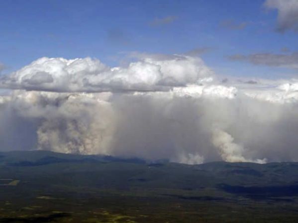
From Canada to Alaska to Siberia, an immense half-crescent of the Arctic is on fire. The hot spots along this zone include freakish fires with 50 mile fronts, fires that generate thunderstorms from the heat of their updrafts, and fires that paint smokescapes over the lake waters of Canada even as they light the sky red:

(Freakish lake fire burns in Saskatchewan, Canada on Monday, July 13. It’s just one of thousands of fires now raging through Arctic lands and 5,105 fires burning through Canada alone.)

Fires, overall, that have been vastly under-reported in the mainstream media. And, even when they are reported, they include often inaccurate qualifiers.

So what the heck is really going on? The human hothouse is generating an ever-greater burning potential throughout the Arctic. One that has erupted toward new levels of intensity this year. One that is plainly and painfully visible to any who care to look.

*   *   *   *   *

In Alaska, a massive area the size of one and one half Connecticuts (7,300 square miles) has already been consumed by fires. A zone of smoldering tundra, boreal forests turned to ash, smoking bogs, and smoldering, thawing permafrost.

But aside from a handful of responsible sources (see also here), the mainstream media just can’t get what is now likely to be the worst fire season ever to strike Alaska right. So let’s take a few moments to set the record straight on what is an unprecedented burning of Alaska’s warming tundra, forests and permafrost. A burning that is related to human greenhouse gas emissions-based heating of the atmosphere in that the thawing permafrost provides additional understory and methane fuels to fires even as it multiplies the number of fire-igniting lightning strikes.

A Failure to Accurately Report on an Ongoing Disaster Directly Linked to Humanity’s Greenhouse Gas Emissions

At first, a sudden, abnormal outbreak of hundreds of wildfires throughout the Arctic state during June was framed ‘not abnormal.’ That is until June shattered all previous records for worst wildfires ever and put all notions that anything normal was going on soundly to bed.

Next, the narrative ran on the false meme that most of the fires were caused by human hands (of the match tossing variety). Any journalist worth their salt, however, could simply check that pseudo factoid against the Alaska Interagency Coordination Center report to find that 377 fires were lightning-caused (well more than half) and that these lightning-caused fires, as of Tuesday, amounted to a whopping 4,675,000 acres burned. The human match, lighter, and campfire ignited fires? A piddly 30,000 acres. In other words, more than 99 percent of all the area burned was due to a warming-intensified proliferation of thunderstorm activity and related lightning strikes.

Alaska Pyrocumulous Clouds

(Pyrocumulus clouds have been popping up like hothouse amplifying daisies all over Alaska since mid June. This ridge fire appears to be in the process of building its own thunderstorm. Image source: ADN.)

Indirectly, we could certainly call this extra lightning human-caused — as the vehicle of greenhouse gas warming has resulted in a marked increase in lightning strikes to the thawing permafrost and heating forest and tundra fuels. But this particular human cause is certainly not of the typical match-throwing, arsonist variety. It’s another story entirely. A much more important story that far too many sources appear to be (unintentionally or deliberately) missing. A story of the plainly visible and worsening impacts of human-forced climate change.

To use any set of language other than to characterize the Alaska burning as unprecedented, freakish, record, and abnormal is vastly irresponsible. Any attempt to attribute the 4,675,000 acres ignited by warming induced lightning strikes to ‘arson’ is equally myopic and misleading. If you’re reading a source that makes these claims, that source is an invalid and untrustworthy reporting medium. One that can’t keep a handle on even the most basic of facts.

Alaska Burning is One Month Ahead of the Worst Fire Year Ever

And when all the dust of this mass misinformation over a critical issue directly related to human-caused climate change settles, we find that Alaska’s fires are now burning at a rate fully one month ahead of the previous all time record fire year of 2004. Tuesday’s total acres burned of 4,705,000 stood but 1,900,000 acres shy of that record. And at the current rate of burning, that total could be consumed within a mere 7-15 days — putting the current Alaska wildfire season, by late July or early August, at new record thresholds with more than a month left for forests, tundra and permafrost to continue to burn.

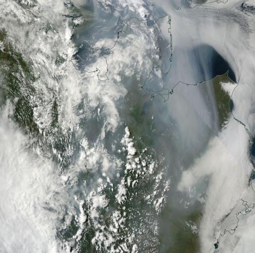
Alaska Wildfires July 14

(Hundreds mile long smoke plumes issuing from Wildfires in Alaska on July 14. Image source: LANCE-MODIS)

In the July 14 MODIS satellite shot we can clearly see massive smoke plumes billowing up from the still energetically burning fires in Central Alaska. Lightning laden cumulonimbus clouds ride overhead — a pattern refreshed by a continuous influx of warm storm moisture rising up over the Gulf of Alaska and deflected off the ridiculously resilient ridge (RRR) to the south. The storms are still setting off around 3-7 fires each day. A rate of new ignition that, though slower than June, is pushing total number of Alaska fires toward the unprecedented 700 line.

7.5 Million Acres Burn in Canada

Across the border in Canada a whopping 5,105 fires are now also consuming vast stretches of Arctic land. It’s an outbreak that resulted in the largest natural disaster evacuation in the history of Saskatchewan. One that has drawn firefighters from all over the world to combat an immense proliferation of blazes. Blazes that have burned about 7.45 million acres so far or an area about the size of 2.3 Connecticuts.

When combined with the Alaska fires, the total area now burned in Arctic sections of North America now equals about 12.1 million acres or more than 1 million acres burned since this time last week. Rates of burning for Canada are, like Alaska, in many cases unprecedented. Total acres burned for the Arctic nation are now at two times the five year average and three times the 25 year average. Specific regions, like British Columbia, are seeing as much as 10 to 20 times the typical area burned by mid July.

Vast Wildfire Eruption in Eastern Siberia

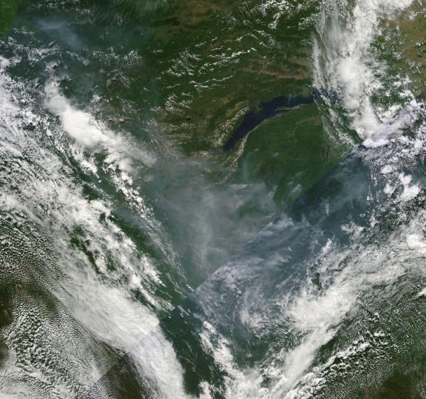
Moving on across the rapidly thinning ice of the Beaufort, Chukchi and East Siberian seas, we find that Eastern Siberia is also experiencing a massive wildfire outbreak. Reports from Russia on acres burned have tended to be spotty. But this zone near Lake Baikal has seen a persistent and then an expanding propagation of burn zones toward the north and east since April.

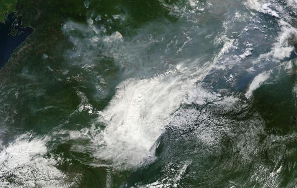
Vast burning in Eastern Siberia

(Vast swath burns through Eastern Siberia on Wednesday. Image source: LANCE-MODIS).

Today, the fire outbreak there could best be described as vast. Stretching from Lake Baikal to the Sea of Okhotsk, the fire zone now encompasses a region more than 1,000 miles across. Scores of large fires can be seen burning beneath a massive cloud of smoke that streams all the way down through China, combining with the nasty coal dust cloud stooping over that fossil fuel victimized state.

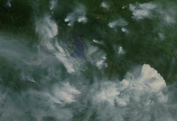
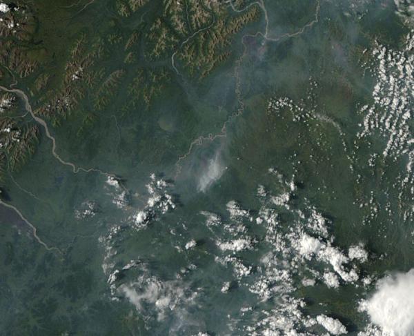
One cluster of these fires, visible in the upper left of the image frame above and zoomed in below features fires with fronts in excess of 50 miles long. These are truly immense fires. Individual blazes large enough to consume small states burning through the carbon rich boreal forests and permafrost zones:

Massive Siberian Wildfires

(Immense fires with fronts as long as 50 miles from end to end ballooned in Siberia today. Image source: LANCE-MODIS).

For reference, the above image’s lower frame edge covers more than 250 miles. This gives us a sense of the utterly huge fires burning away from lower right to center frame.

Conditions in Context — Human-Caused Warming Vastly Increases Arctic Wildfire Potential, Wildfires Make Climate Change Worse

The massive outbreaks of fires in Canada, Alaska and Eastern Siberia during 2015 are not occurring in a vacuum. They are not isolated disasters to simply report, confuse, forget, and then report again when the new record fires erupt in 2016, 2017, 2018 or 2019. They are instead symptoms of a larger trend of polar amplification in the Arctic.

The more than 1,400 billion tons of carbon in the permafrost is now being set to rapidly thaw. The permafrost, when unlocked from its primordial, thousands to millions year old, ice traps yields this carbon in solid, liquid, or gaseous form. The solid peats, the liquid organic carbons, and the methane seeps all provide new and highly volatile fuels for wildfires.

In addition, boreal forests are not fire resilient like their more southerly cousins. The trees there do not typically face flame or intense ignition sources. So when an atmosphere heated by human fossil fuel burning produces powerful, lightning flinging thunderstorms in the Arctic for the first time in thousands to millions of years, the trees there have no natural defense against the fires that inevitably ignite. Individual trees may as well be standing sticks of dynamite in the face of this warmth-driven barrage.

Other factors include tree killing pest invasions, the thin mat of flammable material that underlies most Arctic forests, and the drying tendency of the added heat itself.

So much forest, tundra soil and permafrost burning in the Arctic can eventually have its own sort of warming-amplifying effect. For the fires, fires that are likely not even natural to the slower periods of warming faced by Earth during past hothouse events, rapidly unlock the carbon stored in the forests as well as the rapidly thawing permafrost beneath. This release adds to the already extremely intense carbon emission from human beings and further heightens the danger of hitting climate points of no return.

This is the signal the media has lost in all its talk of ‘not abnormal’ and ‘arson.’ A warning cry from the Arctic. And one we had better not ignore.

Links:

Alaska Interagency Coordination Center

Canadian Interagency Fire Center

LANCE-MODIS

Alaska Wildfire Photos

Montreal Lake Wildfire at 250,000 Acres

Scary Statistics For Alaska Wildfire Season

Wildfires Set off Largest Evacuation in Saskatchewan History

How Climate Change Makes Wildfires Worse and How Wildfires Return the Favor

Hat Tip to Andy in San Diego

Hat Tip to Colorado Bob

Hat Tip to Alexander AC

Hat Tip to DT Lange

Dozens of Massive Wildfires in Central Siberia Belch 1,200 Mile Smoke Plume Over Hot Tundra

1,200 mile smoke plume

(Dozens of monstrous fires belch a 1,200 mile plume of dark smoke over Central Siberia. Image source: LANCE MODIS.)

Let’s just cut to the chase, it’s been hot in Siberia.

This winter, temperatures throughout large swaths of this typically frigid land of tundra and boreal forest ranged between 5 and 7 degrees Celsius above average. For brief periods spikes in the very extreme range of 20 degrees Celsius warmer than normal were not uncommon.

The unusual heat continued into spring igniting a mass of anomalous wildfires in April, a time when most of Siberia remains frozen. By May, more than a million acres had burned, all well before the typical peak of fire season in July and early August. But that was mere prelude to peak fire season, which we are starting to enter now.

Siberian Heatwave Spurs Massive Fires

The record heat this winter was simply the continuation of a long warming trend fueled by human greenhouse gas emissions. Each decade now has seen Siberia warm at a pace double the global average — more than 0.5 degrees Celsius every ten years. And this extra heat is fueling a terrifying intensification of wildfires, a trend that is expected to show at least a doubling of the annual acres burned in this far northern region by the end of this century.

This year’s early start to fire season may be setting the stage for a record or near record burning this year. And today we have a massive flare up of fires in Central Siberia under a broad heat dome over the region.

Temperatures beneath the dome earlier today were in the upper 80s and lower 90s, departures between 5 and 15 degrees Celsius above average for this time of year. This heat spike hit already warmed and dried lands. Lands filled with the added fuel of thawing tundra and the organic carbon and methane pockets beneath. Lands whose shallow surface layer is a tinder bed for flash fires.

Siberian Heat Dome

(Heat dome over Central Siberia in the upper right hand corner of this GFS based-temperature and weather graphic. Image source: University of Maine. Data source: NOAA/GFS.)

The result was the massive wildfire eruption seen in the satellite shot at the top of the page. A very intense set of enormous fires with fronts ranging from 3 to 34 miles burning through boreal forest and tundra land. This set of blazes is even more intense than those seen at this time during the record 2012 Siberian fire season, although it is worth noting that those fires hit extraordinary strength and size by early July and continued in a series of episodes through mid August. The result was massive smoke plumes eventually encircling the Arctic.

Typically, the fires fill the air with particulate and the moisture loading under the heat dome grows ever more intense. Often, and sooner rather than later, a frontal storm accompanied with intense rains sweeps in, catching up the smoke in its cloud mass even as the towering storms douse the raging fires. A song of flood and flame that has become all too common throughout the very rapidly changing Arctic.

In years of very extreme burning, the smoke-laden clouds darken, losing their white, reflective tops. This further amplifies warming over fire-prone areas, setting the stage for more fires. On the ground, the fires plunge ever deeper into the thawing tundra, seeking more and more fuel. In some cases, the fires are reported to have burned the ground to a depth of 3 feet or more, turning both Earth and Tundra into blackened soot while pumping heightening volumes of CO2 into the atmosphere. The dark smoke aloft lifts away, eventually finding a resting place on sea ice or glaciers. There the heating feedback continues over ominously Dark Snow.

The whole terrible process continues until the globe at last tilts away from the summer sun, shutting the whole dreadful feedback down. But each year, we fuel it more through our burning of fossil fuels. Each year, the global greenhouse gas heat forcing ratchets higher and more and more tundra land thaws as the burn line creeps north, providing ever more fuel for the Arctic flames.

Links:

Support the Dark Snow Project

A Song of Flood And Fire

Support and defend our scientists at:

NASA/LANCE MODIS

The University of Maine

NOAA/GFS


Arctic Burning: 3/4 Mile Wide Fire Tornado Over Tetlin Junction, Alaska

(Hat tip to Peter Sinclair who thumbs his nose at the deniers stating, in reaction to this Fire Tornado: “sure, happens all the time.”)

The above is a film recorded on August 16th, 2013 of an explosive fire complex forming a massive fire and smoke tornado 3/4 of a mile across and towering thousands of feet into the air over a ridge line near Tetlin Junction Alaska. Close inspection of the video reveals trees and branches being sucked into the large fire ‘tornado’ caused by very strong inflow along the fire’s leading edge. Tim Whitesell, a firefighter at the scene noted:

“A picture probably is worth a thousand words, but there are indeed times when a picture just doesn’t do it justice. I’ve never seen anything like it until now.”

The terrain features in this region include boreal forest and soil that is mostly permafrost. The film shows both burning trees and ground along with a section involved in an episode of explosive outburst.

Reports from from The Alaska Fire Service are nothing short of stunning:

“This wildland fire footage was captured on August 16, 2013, on the southeast perimeter of the Tetlin Junction Ridge Fire (#414), burning east of Tok and Tetlin junctions, north of the Alaska Highway.

Fire behavior increased into the later part of the afternoon on August 16. At approximately 7:00 p.m., the Alaska Division of Forestry Aerial Supervision Module (consisting of Tim Whitesell and Doug Burts) reported the fire vortex to be about 3/4 of a mile wide; it lasted for about an hour. The extreme fire behavior uprooted trees, a scene that was captured by this footage- look for trees being blown around in the smoke column at the end of the clip.”

The blaze that sparked this massive fire tornado is arguably one of the smaller events to impact the Arctic this year, just a fraction of the size of larger infernos that have raged through areas of Canada and Russia since June. In ‘Russia Experiences Great Burning’ MODIS shots identified fire complexes and burn scars that covered 100 to 300 square miles or more (one fire burn scar measured a massive 30×70 miles). These events happened ‘off camera’ so there is no way to know if they also spawned very large fire tornadoes similar to the kind witnessed at Tetlin Ridge. What is clear from this fire and from fires across the Arctic this year and last is that the far north is burning like never before. As Russia’s eastern provinces experienced some of their worst flooding in 120 years, massive wildfires continued to burn even as the terrible rains and storm complexes advanced in an ominous Song of Flood and Fire. By now, the extent of Russian blazes has been somewhat lessened by these storms, although fire maps still show numerous active blazes.

A satellite picture of the blazing ridge-line on August 15 is given below.  The fire is located in the center of the image and spans about 5×10 miles of the affected ridge line. You can also see the burn scars of previous wildfires in the lands surrounding the August 15-16 blaze.

Tetlin Junction Fire Tornado

Tetlin Junction Fire Tornado

(Image source: NASA/Lance-Modis)

Thawing permafrost, warming forests, Arctic heatwaves and more energetic storms combine to provide massive volumes of warming fuel and increasingly powerful ignition events in the Arctic. Not only can trees burn, but the organic carbon stored in permafrost and sometimes bottled up as methane beneath the surface also provides fuel. In many cases, fires have burned three feet deep into what was the permafrost bed below consuming roots, stumps and soil.

Very large and energetic fire outbreaks have been increasing throughout the Arctic with recent years seeing some of the worst fires on record.

Links, Credits and Hat Tips:

The Alaska Fire Service

Climate Crocks

NASA/Lance-Modis

Colorado Bob

Robin Westenra

Wildfires Burn More Than 1 Million Acres in Quebec, Canada; 121 Firefighters Called in For Help

On May 25th, a large thunderstorm ignited wildfires across Quebec. They have been burning ever since.

In total, more than 1 million acres (or about 1000 square miles) of forest had burned as of July 9th. The fires had become so severe that by July 5th, they’d shut off power to more than 500,000 residents (10% of the Quebec population), prompted Quebec to declare a state of emergency, and threatened many towns throughout the region. A vast pall of smoke hung over much of the area, stretching as far as Ontario, some 400 miles away, where severe smog resulted in air hazard, health warnings, and pleas from officials for residents to limit driving.

The following video provides an excellent description of this major fire-related smog event:

Temporary relief came when rains swept through the area on July 7th and 8th. But the fires quickly recovered causing Quebec to send out pleas for additional fire crews from the Northeastern US and broader Canada. So far, Maine, Massachusetts and British Columbia have responded by sending a total of 121 firefighters to battle the massive blazes.

Quebec Wildfires

(Quebec Wildfires on July 9th. Image source: Lance-Modis)

In the above Aqua satellite image provided by NASA, you can see a number of these large fires burning in the vicinity of southern Hudson bay in the northwest region of Quebec. The fires still raged after a number of rainstorms swept through the area on July 7th and 8th.

Adding insult to injury, a train carrying 72 cars laden with crude oil derailed and exploded in the Quebec town of Lac Megantic, likely killing 50 people and forcing over 2,000 to evacuate. The wildfires and oil train explosion formed a hot concoction of global warming and Canadian dependence on petroleum this week that made for a very volatile, damaging and deadly mixture.

Conditions in Context

Northern Quebec is yet one more Arctic region to experience large wildfires this summer. Northern Canada, Alaska and Siberia have all also seen large and powerful fires burning near or above the Arctic circle. Most fires have been ignited by dry or heat-wave conditions. In the case of Canada, Alaska and Siberia, temperatures surged from the high 80s to the mid 90s. One central Alaska location recorded an all-time record of 98 degrees Fahrenheit. Resulting thunderstorms in these areas sparked massive tundra, peat, and arboreal forest fires.

These Arctic wildfires and heat waves are particularly disturbing when you factor in a new Los Alamos study showing that soot from forest fires is a more powerful amplifying feedback to human warming than previously estimated. Soot generated from this burning is more local to remaining sea and land ice. Wind and weather can deposit this soot onto icy regions reducing their albedo and hampering their resilience to the 24 hour summer sun.

These fires also occur in a region that is, increasingly, emitting more and more methane and carbon dioxide into the atmosphere — additional amplifying feedbacks that contribute both to Arctic warming and to larger global warming. High volumes of methane in tundra, peat, and permafrost melt lakes may also provide trigger zones that ignite these kinds of Arctic fires. In these areas, methane concentrations are sometimes high enough to burn if ignited by a spark, lightning, or a wildfire raging in the area. Though it seems counter-intuitive, these combined conditions may make the Arctic one of the most vulnerable regions to burning from massive fires as the effects of human global warming progress.

The northwestern area of Quebec primarily features arboreal forest. But sporadic regions of permafrost dot the area and melt/decay of this permafrost has been particularly rapid as warmth has advanced northward over the past few decades. This year, the driest spring and early summer in 40 years led to conditions that would encourage the record burning from May to July. As of July 9th, three very large fires were still raging in the vicinity of James Bay, some of them devouring woodlands at a speed of near 20 miles per hour.

A strong low pressure system is forming over Quebec today and is predicted to deepen before moving northeast by Saturday. This storm may bring more rains to the fire stricken area. As of today, there were some reports of light rain, high humidity and fog. All conditions that are likely to aid firefighting and containment efforts. It is worth noting that, thus far, rainfall has not been enough to alleviate record dry conditions in the area. It is also worth pointing out that fires rapidly re-surged to dangerous levels after previous rains fell in early July. So firefighters and communities in Quebec may be in it for the long haul.

Links:

BC Sends 100 Firefighters to Quebec

Quebec Families told 30 Missing After Train Crash are Likely Dead

15 Massachusetts Firefighters Sent to Quebec to Battle Massive Blazes